

- •Table of Contents
- •Congratulations!
- •Scope
- •How to use this manual
- •Prerequisites
- •Conventions and Customer Service
- •What’s New!
- •Precise Point Positioning (PPP) processor
- •Software License
- •Warranty
- •Introduction and Installation
- •1.1 Waypoint Products Group Software Overview
- •1.2 Installation
- •1.2.1 What You Need To Start
- •1.2.2 CD Contents and Installation
- •1.2.3 Upgrading
- •1.3 Processing Modes and Solutions
- •1.4 Overview of the Products
- •1.4.1 GrafNav
- •1.4.2 GrafNet
- •1.4.3 GrafNav Lite
- •1.4.4 GrafNav / GrafNet Static
- •1.4.5 GrafMov
- •1.4.6 GrafNav Batch
- •1.4.7 Inertial Explorer
- •1.5 Utilities
- •1.5.1 Copy User Files
- •1.5.2 Download Service Data
- •1.5.3 GPS Data Logger
- •1.5.4 GPB Viewer
- •1.5.5 Mission Planner
- •1.5.6 Data Converter
- •GrafNav
- •2.1 GrafNav, GrafNav Lite and GrafNav / GrafNet Static Overview
- •2.2 Start a Project with GrafNav
- •2.3 File Menu
- •2.3.1 New Project
- •2.3.2 Open
- •2.3.3 Save Project
- •2.3.4 Save As
- •2.3.5 Print
- •2.3.6 Add Master Files
- •2.3.7 Add Remote Files
- •2.3.8 Alternate Precise / Correction Files
- •2.3.9 Show Master Files
- •2.3.10 Load
- •2.3.12 GPB Utilities
- •2.3.13 Remove Processing Files
- •2.3.15 Recent projects
- •2.3.16 Exit
- •2.4 View Menu
- •2.4.1 GPS Observations
- •2.4.2 Forward and Reverse Solutions
- •2.4.3 Processing History
- •2.4.4 Processing Summary
- •2.4.5 Return Status
- •2.4.6 Features
- •2.4.7 Objects
- •2.4.8 ASCII File (s)
- •2.4.10 Current CFG File
- •2.5 Process Menu
- •2.5.1 Process GNSS (differential)
- •2.5.2 Process PPP (single point)
- •2.5.3 Combine Solutions
- •2.5.4 Launch Batch Processor
- •2.5.5 Stop Auto Run
- •2.5.6 Load GNSS Solution
- •2.5.7 Load PPP Solution
- •2.5.8 Load Any Solution
- •2.5.9 Import Solutions and Setting
- •2.6 Settings Menu
- •2.6.1 GNSS Processing
- •2.6.2 PPP Processing
- •2.6.3 Coordinate
- •2.6.4 Individual
- •2.6.5 Datum
- •2.6.6 DEM Plotting
- •2.6.7 Photogrammetry
- •2.6.8 Manage Profiles
- •2.6.9 Compare Configuration Files
- •2.6.10 Preferences
- •2.7 Output Menu
- •2.7.1 Plot GPS Data
- •2.7.3 Plot Master / Remote Satellite Lock
- •2.7.4 Export Wizard
- •2.7.5 Write Coordinates
- •2.7.6 View Coordinates
- •2.7.7 Export Binary Values
- •2.7.8 Write Combined File
- •2.7.9 Build HTML Report
- •2.7.10 Export to Google Earth
- •2.7.11 Show Map Window
- •2.7.12 Processing Window
- •2.8 Tools Menu
- •2.8.1 Zoom In & Zoom Out
- •2.8.2 Distance & Azimuth Tool
- •2.8.3 Move Pane
- •2.8.4 Find Epoch Time
- •2.8.5 Datum Manager
- •2.8.6 Geoid
- •2.8.7 Grid/Map Projection
- •2.8.8 Convert Coordinate File
- •2.8.9 Time Conversion
- •2.8.10 Favourites Manager
- •2.8.11 Mission Planner
- •2.8.12 Download Service Data
- •2.9 Window Menu
- •2.9.1 Cascade
- •2.9.2 Tile
- •2.9.3 Next and Previous
- •2.9.4 Close Window
- •2.9.5 Close All Windows
- •2.10 Help Menu
- •2.10.1 Help Topics
- •2.10.2 www.novatel.com
- •2.10.3 About GrafNav
- •GrafNet
- •3.1 GrafNet Overview
- •3.1.1 Types of Networks
- •3.1.2 Solution Types
- •3.1.3 Computing Coordinates
- •3.2 Start a Project with GrafNet
- •3.2.1 Fix Bad Baselines
- •3.2.2 Unfixable Data
- •3.3 File
- •3.3.1 New Project
- •3.3.2 Open Project
- •3.3.3 Save Project
- •3.3.4 Save As
- •3.3.5 Print
- •3.3.6 Add / Remove Observations
- •3.3.7 Add / Remove Control Points
- •3.3.8 Add / Remove Check Points
- •3.3.9 Alternate Ephemeris / Correction Files
- •3.3.10 Remove Processing Files
- •3.3.11 Import Project Files
- •3.3.12 View
- •3.3.13 Convert
- •3.3.14 GPB Utilities
- •3.3.15 Recent projects
- •3.3.16 Exit
- •3.4 Process Menu
- •3.4.1 Processing Sessions
- •3.4.2 Rescanning Solution Files
- •3.4.3 Ignore Trivial Sessions
- •3.4.4 Unignore All Sessions
- •3.4.5 Compute Loop Ties
- •3.4.6 Network Adjustment
- •3.4.7 View Traverse Solution
- •3.4.8 View Processing Report
- •3.4.9 View All Sessions
- •3.4.10 View All Observations
- •3.4.11 View All Stations
- •3.5 Options Menu
- •3.5.1 Global Settings
- •3.5.3 Datum Options
- •3.5.4 Grid Options
- •3.5.5 Geoid Options
- •3.5.6 Preferences
- •3.6 Output Menu
- •3.6.1 Export Wizard
- •3.6.2 Write Coordinates
- •3.6.3 View Coordinates
- •3.6.4 Export DXF
- •3.6.5 Show Map Window
- •3.6.6 Show Data Window
- •3.6.7 Baselines Window
- •3.6.8 Processing Window
- •3.7 Tools Menu
- •3.8 Help Menu
- •GrafNav Batch
- •4.1 Overview of GrafNav Batch
- •4.1.1 Getting Started with GrafNav Batch
- •4.2 File Menu
- •4.2.1 New Project
- •4.2.2 Open Project
- •4.2.3 Save Project
- •4.2.4 Save As
- •4.2.5 Print
- •4.2.6 Add Baselines
- •4.2.8 Add Combined Baselines
- •4.2.9 Import CFG Files
- •4.2.10 Edit Selected Baseline Settings
- •4.2.11 Removing Selected Baselines
- •4.2.12 View ASCII Files
- •4.2.13 View Raw GPS Data
- •4.2.14 Convert GPS Data
- •4.2.15 GPB Utilities
- •4.2.16 Remove Process Files
- •4.2.17 Recent Projects
- •4.2.18 Exit
- •4.3 Process Menu
- •4.3.1 Process All Baselines
- •4.3.2 Process Selected
- •4.3.3 GrafNav on Selected Baselines
- •4.3.4 View Selected Processing Summary
- •4.3.5 Load All Solutions
- •4.3.6 Load Selected Solutions
- •4.4 Settings Menu
- •4.4.1 Global
- •4.4.2 Selected
- •4.4.3 Copy Processing Options
- •4.4.4 Load into Selected From
- •4.4.5 Manage
- •4.4.6 Preferences
- •4.5 Output Menu
- •4.5.1 Plot Selected GPS Data
- •4.5.2 View Selected Map
- •4.5.3 Export All
- •4.5.4 Export Selected
- •4.6 Tools Menu
- •4.7 Windows
- •4.8 Help Menu
- •GrafMov
- •5.1 Overview of GrafMov
- •5.2 Getting Started with GrafMov
- •5.3 File Menu
- •5.3.1 Add Master File
- •5.4 View Menu
- •5.5 Process Menu
- •5.6 Setting Menu
- •5.6.1 Moving Baseline Options
- •5.7 Output Menu
- •5.7.1 Plot GPS Data
- •5.8 Tools Menu
- •5.9 Interactive Windows
- •5.10 Help Menu
- •AutoNav
- •6.1 Overview of AutoNav
- •6.2 Getting Started with AutoNav
- •6.3 Base Station Files
- •6.4 Remote Files
- •6.5 Interactive Windows
- •File Formats
- •7.1 Overview of the File Formats
- •7.2 CFG File
- •7.3 GPS Data Files
- •7.3.1 GPB File
- •7.3.2 STA File
- •7.3.3 Old Station File Format
- •7.3.4 EPP File
- •7.4 Output Files
- •7.4.1 FML & RML Files
- •7.4.2 FSS & RSS Files
- •7.4.3 FWD & REV Files
- •7.4.4 FBV & RBV Files
- •Utilities
- •8.1 Utilities Overview
- •8.2 GPB Viewer Overview
- •8.2.1 File
- •8.2.2 Move
- •8.2.3 Edit
- •8.3 Concatenate, Splice and Resample Overview
- •8.3.1 Concatenate, Splice and Resample GPB Files
- •8.4 GPS Data Converter Overview
- •8.4.1 Convert Raw GPS data to GPB
- •8.4.2 Supported Receivers
- •8.5 GPS Data Logger Overview
- •8.5.1 Getting Started with WLOG
- •8.5.2 File
- •8.5.3 Display
- •8.5.4 Plot
- •8.5.5 Zoom Menu
- •8.5.6 Events Menu
- •8.6 WinCE Data Logger Overview
- •8.6.1 Installing CELOG
- •8.6.2 Getting Started with CELOG
- •8.6.3 Variable Display File
- •FAQ and Tips
- •9.1 Overview of FAQ and Tips
- •9.2 General FAQ and Tips
- •9.2.1 How can I store Master Station Coordinates?
- •9.2.2 How can I obtain Master Station Coordinates?
- •9.2.3 How can I customize output formats?
- •9.2.4 How can I download base station data?
- •9.3 Kinematic Processing FAQ and Tips
- •9.3.2 Should I combine forward and reverse solutions?
- •9.3.3 How can I use static / kinematic flags?
- •9.3.4 How do I eliminate problem satellites?
- •9.3.5 How do I set the measurement standard deviations?
- •9.3.6 How do I control bad data?
- •9.3.7 How do I avoid missing epochs?
- •9.3.8 Should I avoid using RINEX for kinematic data?
- •9.3.9 How do I process kinematic data logged during an ionospheric storm?
- •9.3.10 How do I process long kinematic baselines?
- •9.4 Integer Ambiguity Determination Tips
- •9.4.1 How can I detect and fix incorrect integer fixes?
- •9.4.2 How can I help KAR/ARTK find a solution?
- •9.4.3 How can I use KAR and ARTK to improve poor combined separations?
- •9.5 Static Processing FAQ and Tips
- •9.5.1 Can I use GrafNet for static batch processing?
- •9.5.2 Can I use kinematic processing on static baselines?
- •9.5.3 Using KAR or ARTK in GrafNet
- •9.5.4 How can I optimize the fixed static solution?
- •9.5.5 How can I refine L1/L2 integer solutions?
- •9.5.6 Can I use a larger interval for static processing?
- •9.5.7 How do I process static data logged during ionospheric storms?
- •9.5.8 How do I process long static baselines?
- •9.6.1 How should I choose a processing mode?
- •9.6.2 How important are base station coordinates?
- •9.6.3 How can I use the MB Plots?
- •9.6.4 How do I select a data interval?
- •9.6.6 How should I decide which base stations to use?
- •9.6.7 How do I deal with problematic baselines?
- •9.6.9 How can I use the fixed static solution?
- •9.6.10 What is the best way to process data with large base to rover separations?
- •9.6.11 How can I speed up processing?
- •9.7 PPP (Precise Point Positioning)
- •9.7.1 What is Precise Point Positioning?
- •9.7.2 How does PPP differ from differential processing?
- •9.7.3 How accurate is PPP?
- •9.7.4 What is PPP used for?
- •9.7.5 Who should use PPP?
- •9.7.6 Are there any limitations to PPP?
- •9.8 Common Inquiries
- •9.8.1 How can I determine the quality of a final solution?
- •9.8.2 How do I copy user files?
- •9.8.3 How do I update manufacturer files?
- •9.8.4 How do I produce local coordinates?
- •9.8.5 How do I define a local cartesian coordinate system?
- •9.8.6 How do I define a local coordinate grid?
- •9.8.7 How do I process an aerial survey with camera event marks?
- •9.9 Digital Elevation Models (DEM) FAQ and Tips
- •9.9.1 Why would I use a DEM?
- •9.9.2 What are the DEM sources?
- •9.9.3 What DEM formats are supported by GrafNav?
- •9.9.4 How do I handle large DEMs?
- •9.10 Datum FAQ and Tips
- •9.10.1 What are the available datums - related features?
- •9.10.2 How are datums handled within the software?
- •9.10.3 How do I make additional datums available?
- •9.10.4 How do I enter a 7-parameter transformation?
- •9.10.6 How do I use NADCON conversion files?
- •9.10.7 How do I prevent corruption from conversion errors?
- •9.11 Projections FAQ and Tips
- •9.11.1 What features are available with map projections?
- •9.12 Geoid FAQ and Tips
- •9.12.1 What are the available geoid - related features?
- •9.12.2 How can I create a WPG file?
- •A: Output Variables
- •B: Antenna Measurements Diagram
- •C: Summary of Commands
- •Index
Appendices
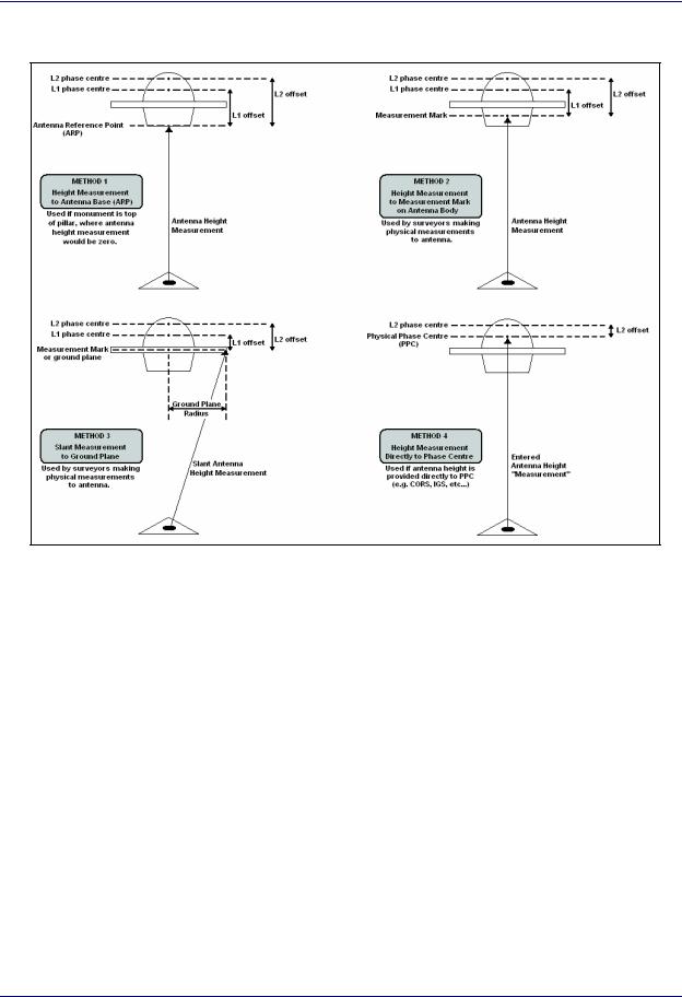
B: Antenna Measurements Diagram
Figure 9: Antenna Measurements
GrafNav / GrafNet 8.10 User Guide Rev 4 |
295 |

Appendices
C: Summary of Commands
The following lists the available commands and a short description of their usage. The required format, status, and a description of each command is given. Any subset of the following may be used for the user’s particular input file. User commands can also be observed via Settings | Individual | User Defined in GrafNav. Note that any spaces in file names, datum names, and so on, are substituted in the configuration file with an asterisk (*).
ALT_FILE = fname EPP/SP3/CLK/IONEX ENABLE/DISABLE
This specifies the alternate ephemeris file (.epp file), or precise ephemeris (.sp3), or IONEX file (.yyI), or Satellite Clock file (.clk). They are set to ENABLE once added to the project. DISABLE will disable the processor from using the file.
APPLY_ANT = ON/OFF |
Set to ON if elevation based antenna corrections are to be |
|
employed. Note that an antenna profile must also be specified for |
|
master and/or remote receivers. This is ON by default; use OFF |
|
to disable antenna correction.AZ_DETERM = ON/OFF Dist |
|
DistSDGrafMov only. Used to enable azimuth computation |
|
using an antenna distance constraint. Distance and standard devi- |
|
ation are in meters. Typical standard deviations are 2-3 cm. |
BASE_SAT = sv_num |
Satellite PRN number of base satellite used for differenced com- |
|
putations. Normally, this value should be left at 99, which will |
|
cause the program to automatically choose the best satellite using |
|
a number of criteria. The default value is 99. |
CYCLE_TEST = mode |
This can be LOCKTIME, DOPPLER, or BOTH, and determines |
|
the manner in which cycle slips are detected in kinematic mode. |
|
In general, either BOTH or DOPPLER should be used. Basically, |
|
using DOPPLER will disable LOCKTIME check. |
CYCLE_TOL = tol |
Tolerance used to detect cycle slips on the L1 phase in kinematic |
|
mode. These tolerances generally vary from 1 - 500 cycles, and |
|
depend on receiver type, vehicle dynamics and type of Doppler. |
|
Numerous cycle slips reported may indicate that CYCLE_TOL is |
|
too low. A value of 0.0 will cause cycle slip tolerance to be com- |
|
puted automatically from data interval. This value is also subse- |
|
quently multiplied by 30 [default is 0.0]. |
DATUM = ProcDatum [Wgs84Conv] |
This is the datum that processing is to be performed in, and the |
|
satellite coordinates are transformed into this datum. See |
|
GrafNav for a list of available datums. WGS84Conv is the con- |
|
version to be used. Use WGS84Conv=AUTO to allow |
|
NGPS32.DLL to select the best datum. Note that datums are read |
|
from manufact.dtm and user.dtm located in the same directory as |
|
the DLL. |
DETAILED_SUM = ON/OFF |
ON if detailed parameter info is to be printed at the start of the |
|
static/kar summary (.fss/rss) file. |
GrafNav / GrafNet 8.10 User Guide Rev 4 |
296 |

|
Appendices |
|
|
|
|
DOP_TOL = dd_dop_tol |
Epochs with DD_DOP above this value are not printed to .FWD/ |
|
|
REV files as the geometry is deemed too poor. Default value is |
|
|
100.0. |
|
DOPPLER_TOL = tol |
No longer supported. |
|
DUAL_FREQUENCY = on/off on/off off/relative/free on/off/smoothed OFF/ON
Use P-code for long baseline processing. No longer used; see USE_PCODE command.
OFF/ON - Use L2 phase for ambiguity resolution (should be ON).
OFF/RELATIVE/FREE – Use relative ionospheric correction or long baseline L3 iono-free baseline processing ON/OFF/SMOOTHED – Apply ionospheric correction to C/A. SMOOTHED applies a low pass filter to the raw ionospheric corrections before implementing them.
DYNAMICS = EnableFlag DynFlag |
This parameter controls the vehicle dynamics model that can be |
|
employed in the Kalman filter. EnableFlag=ON/OFF/AUTO, |
|
while DynFlag=LOW/MEDIUM/HIGH. Generally AUTO |
|
should be used, which means that dynamics constraint is off if |
|
Doppler is employed or ON if no Doppler is used. If ON, HIGH |
|
dynamics is used. If ON, use DynFlag to set vehicle dynamics. |
ELEV_MASK = angle |
Cut-of elevation for excluding satellites from the computations. |
|
This value is expressed in degrees. This elevation mask value |
|
may have to be increased to 15 degrees or more in high multi- |
|
path environments or during ionospheric storms. Some data |
|
tracked under 10 degrees may exhibit noise characteristics. |
|
Default value is 10.0. |
FF_DOP_TOL = dop_tol |
DD_DOP Tolerance over which a fixed integer solution is |
|
deemed “float”. Allows user to control how easily a fixed |
|
changes to a float solution. Does not affect processing. Default is |
|
25. |
FIX_AUTO = Min DtL2 MaxLenL2 MinDtL1 MaxDtL1 ON/OFF
Controls automatic fixed static solution usage on static sessions. Use ‘ON’ to enable, or “OFF’ to always use. Note that fixed static must also enabled in processing settings. MinDt is minimum time length in seconds while MaxLen is maximum allowable distance in km.
FIX_CORRECT_SLIP = ON/OFF |
ON if whole cycle slips are to be corrected forming a continuous |
|
phase in fixed solution. By default this option is ON. |
FIX_CUBE = mode L1User L2User |
Mode is AUTOREDUCE, NORMAL, or USER. Sets the search |
GrafNav / GrafNet 8.10 User Guide Rev 4 |
297 |

|
Appendices |
|
|
|
|
|
region size for fixed solution. L1User and L2User are the sizes of |
|
|
the search are to be used for USER mode. Default is NORMAL. |
|
|
AUTOREDUCE often works very well. |
|
FIX_INTERVAL = DataInterval |
Data interval in seconds to use for fixed static processing. |
|
|
Default is 15 seconds. |
|
FIX_IONO_DIST = dist |
Used in the AUTO fixed solution L2 model for deciding between |
|
|
IONO and NORMAL L2 noise models. dist is in kilometers. |
|
|
Default is 5 km. |
|
FIX_L2_NOISE = IONO/NORMAL/AUTO
Selects L2 noise model for processing fixed solution. IONO performs iono correction, NORMAL does not, AUTO selects between the two based on the FIXED_IONO_DIST command.
HGT_MODEL = EstFlg KalFlg KarFlg ZOff/USEHI HgtSd [KarTol]
Controls DEM height constraint (Sportvision version only!) EstFlag = NAV / ALL / OFF
Kar/KalFlag = ON / OFF
INITEX = type time snap dir windowsize stdev anthgt phi lamda ht [[staname or ss_index] anthgt ELL/ORTHO]
Used to set the remote position at a given location. See GrafNav user interface.
INTERVAL = DataInterval |
This specifies the processing interval in seconds. It should be |
|
equal to or greater than the recording interval for proper time |
|
length computations. If this value is larger than the recording |
|
interval, then this new value will be used for processing. Use 0.0 |
|
to process all epochs. The default value is 0.0. |
IONO_DIST = dist_in_km |
Baseline distance in km at which relative iono-free processing |
|
will begin. Default is 5 km. |
IONO_PPM_TOL = tol |
Reject KAR or fixed static solutions if computed ionospheric |
|
error is greater than tol in PPM. Default value is 10 PPM. This |
|
setting is not in GrafNav’s dialogue boxes. |
ISSUE_KAR_DIST = ON/OFF DistKm1 DistKm2
This will engage KAR on first occurrence of dist < dist1 and reset the distance check when dist > dist2.
ISSUE_KAR_DOP = ON/OFF doptol Engage KAR every time DD_DOP goes above doptol.
ISSUE_KAR_TIME = ON/OFF NumMin Engage KAR every ‘NumMin’ minutes.
KAR_COV_L2 = ON/OFF sf offset Determines KAR search area using ambiguity variances. Search
GrafNav / GrafNet 8.10 User Guide Rev 4 |
298 |

Appendices
area is computed to be SearchArea=+/- sf*AmbVar + offset. This option only works for dual frequency processing.
KAR_CUBE = cube_size_l1 cube_size_l2
Size of kinematic ambiguity resolution (KAR) search cube in meters. A cube +/- cube_size/2 will be searched from the initial approximate position, which is obtained from the program following the loss of lock. The default value is 2.0 m. This value should be increased if it is suspected that the remote position is outside of the search cube. However, larger values increase the possibility of an incorrect intersection found.
KAR_DISTANCE = l1_dist l2_dist |
Do not engage KAR if distance is greater than value. Distances |
|
are defined in km. After KAR is engaged, it will search farther. |
|
Use KAR_USE_DIST to prevent KAR from utilizing data past a |
|
certain distance. |
KAR_ELEV_MODEL = ON/OFF |
Default is ON. KAR uses the KAR_TWOSTAGE_SAT highest |
|
satellites for its ambiguity search. |
KAR_EPOCH_FILTER = epoch_size |
Interval between storing epochs for KAR. epoch_size specified |
|
in seconds. This controls how much data KAR will use. |
KAR_EPOCH_SIZE = epochs_l1 epochs_l2
Number of epochs between KAR ambiguity searches if L1 only or L1/L2. This controls how often KAR will search.
KAR_EXACT_INTERVAL = ON/OFF |
Only use epochs exactly on KAR_EPOCH_FILTER in KAR. |
KAR_FAST = ON/OFF |
ON to enable ‘Fast KAR’ |
KAR_IONO_DIST = dist_in_km |
Used in auto L2 noise model for choosing between HIGH and |
|
IONO. |
KAR_L2_NOISE = AUTO/HIGH/IONO/MEDIUM/LOW
Model used for KAR L1/L2 ambiguity search. Default is AUTO.
KAR_MAX_DOP = 7.0 |
Tolerance for allowable DOP during a KAR solution. Default is |
|
9.0. |
KAR_MAX_TIME = 30 |
After this number of minutes, KAR will restart searching |
KAR_MB_NEAREST = ON/OFF |
If this option is turned ON, KAR will use the nearest base station |
|
to engage (Multi-baseline processing only). |
KAR_MIN_ADD = NumMinutes |
Minutes added to the minimum KAR time for every 10 km in |
|
baseline length. Default is 1.5 minutes. |
GrafNav / GrafNet 8.10 User Guide Rev 4 |
299 |

|
Appendices |
|
|
|
|
KAR_MIN_TIME = L1time L2time |
Minimum number of minutes for single and dual frequency pro- |
|
|
cessing before KAR is searching begins. |
|
KAR_OUTPUT = ON/OFF |
TRUE if KAR is to output additional information for FWD/REV |
|
|
files. |
|
KAR_RELTOL = tol |
Reliability is calculated by dividing the lowest intersection RMS |
|
|
by that of the second lowest. Reliable intersections should have |
|
|
values of 1.5 or higher and preferably greater than 2.0. Default is |
|
|
1.5. |
|
KAR_RMS_TOL = 0.075 |
Tolerance for KAR statistical test on the RMS phase. Default is |
|
|
0.065 cycles. |
|
KAR_RMSKEEPTOL = tol |
If the RMS from a KAR solution is higher than this tolerance |
|
|
(cycles), then a warning will result. If there are still 4 good satel- |
|
|
lites (see KAR_MAXSV), this solution will not be used. Default |
|
|
value is 0.06 cycles. |
|
KAR_RMSUSETOL = tol |
This is the tolerance (cycles) with which intersections will be |
|
|
kept in the list. This value should be 0.20 or higher. The default is |
|
|
0.20 cycles. |
|
KAR_SEP_TOL = 2.0 |
Tolerance for allowable separation between the float and fixed |
|
|
KAR solutions. This option can be used to “kick out” solutions |
|
|
with large float/fixed separations. |
|
KAR_STATIC = ON/OFF |
Turn ON to engage KAR in static mode. By default this option is |
|
|
OFF. |
|
KAR_STRICT_TOL = rmsflag relflag |
rmsflag=ON/OFF and enables stricter RMS tolerance for reject- |
|
|
ing bad KAR solutions. relflag=ON/OFF and it enables stricter |
|
|
reliability tolerance. |
|
KAR_TWOSTAGE_SATS = 6 |
Use this maximum number of satellites in the KAR ambiguity |
|
|
search routines. |
|
KAR_USE_DIST = ON/OFF MaxL1Dist MaxL2Dist
ON to prevent KAR from using long baseline data. Tolerances for single and dual frequency processing are in km. Normally computed automatically from KAR_DISTANCE.
KAR_USE_FAR = ON/OFF |
ON if KAR to use all data less than distance tolerances. OFF will |
|
just use data until maximum distance exceeded. Default is off. |
L2_LOCKTIME = ON/OFF |
ON to use L2 locktime for cycle slip detection. For some receiv- |
GrafNav / GrafNet 8.10 User Guide Rev 4 |
300 |
|
Appendices |
|
|
|
|
|
ers (for example, Ashtech), this can lead to more cycle slips |
|
|
being detected than really do occur. |
|
L2_MAIN = ON/OFF |
If turned ON, GrafNav will only use P2/L2 for single frequency |
|
|
processing (special applications only). |
|
L2_SLIP_TOL = 0.20 |
Tolerance in L2 cycles at which an L2 cycle slip will be assumed. |
|
|
Default is 0.4 cycles. |
|
LOCKTIME_CUTOFF = 8 |
Phase data will be ignored for the first 8 seconds after locking |
|
|
onto the satellite. Change this value to 0 to process all phase data |
|
|
or a large value to ignore the first n seconds of lock. This gives |
|
|
the phase lock loop a chance to stabilize. |
|
MB_MASTER_ANT = L1VertHgt [L2Corr MeasDist SlantFlag(1/0) ProfileName] MeasToPC
This is the extended version of the antenna height for a multibase master station. Only first two parameters and ProfileName used by processing engine.
MB_MASTER_DISABLE = ON/OFF |
ON if the master station is to be disabled from processing. |
MB_MASTER_FILE = Filename |
The name of the multi-base master file (.GPB file). Use * as |
|
spaces. |
MB_MASTER_INDEX = iIndex |
Index of the master file in the project. Note that this starts at 0. It |
|
must proceed MB_MASTER_??? commands which refer to this |
|
location. |
MB_MASTER_NAME = StaName |
This is the name of the master station used in multi-baseline pro- |
|
cessing for identification and baseline settings matching. This |
|
name is also displayed on the map and used to refer to station/ |
|
baseline specific settings. |
MB_MASTER_POS = LatDeg LatMin LatSec LonDeg LonMin LonSec Ht(m)
These are the coordinates of a master station. The latitude and longitude must be entered in degrees minutes seconds with spaces in between. Latitude is positive in the Northern Hemisphere and negative in the southern. Longitude is positive in the Eastern Hemisphere and negative in the western (Americas).
MOVING_BASE = ON/OFF |
Moving Baseline Option Only. If ON, this indicates to the Graf- |
|
Mov module that the base station is in dynamic mode as well as |
|
the remote. If MOVING_BASE=OFF, conventional processing |
|
is performed. |
MOVING_BASE_FILE = Filename |
No longer supported. |
GrafNav / GrafNet 8.10 User Guide Rev 4 |
301 |

|
Appendices |
|
|
|
|
NAV_TOL = dist_in_m |
Distance before using DGPS based navigation approximation. |
|
|
Affect Kalman filter convergence for slowly moving objects. |
|
NOWRITE_HIGH = ON/OFF |
Does not export epochs to the .FWD/.REV if statistics are too |
|
|
poor (if ON used). |
|
OMIT = KAR/PROC $name/ALL sv#/ALL RANGE/ALL [start end]
This controls omitted objects (such as baselines and satellites) from GrafNav processing. KAR = remove from KAR/fixed static; PROC = remove from all processing; $name is baseline name (or use ALL); use start end to define RANGE of times to omit.
OUTPUT_MODE = NORMAL/EXTENDED
Determines output format for the ASCII FWD and REV files. EXTENDED includes velocity and ambiguity values.
POS_DENSITY = 1.0 This is the spectral density of the position states. The user may want to increase this value to 10 or more under high dynamics. This value should be left at 1.0 (default).
PPP_SP3_DATUM = Datum Conversion
|
Datum used for SP3 precise ephemeris and associated conver- |
|
sion to local datum. |
PPP_PROCDESC = Description |
Description of processing run. Used by Processing History fea- |
|
ture. |
PPP_PROCTIME = Time Date |
Time, in HH:MM:SS format, and date, in MM/DD/YY format. |
PPP_PROCUSER = Name |
Name or initials of user. Used by Processing History feature. |
PPP_PROCESS_MODE = PPP/SFCA/DFCA/AUTP |
|
|
Specifies the single point processing mode. Dual frequency car- |
|
rier phase [PPP], single frequency C/A code (SFCA), dual fre- |
|
quency C/A code (DFCA), automatic (AUTO). |
PPP_USEP1OVERCA = ON/OFF |
Turn ON to use P1 measurements in place of C/A code measure- |
|
ments. Requires new GPB format. |
PPP_USESOLVEDCLOCK = ON/OFF |
|
|
ON to use solved clock bias, or OFF to use corrected receive |
|
time from GPB file. |
PPP_PRECISEONLY = ON/OFF |
ON if only satellites with precise ephemeris and clock values are |
|
to be used. |
GrafNav / GrafNet 8.10 User Guide Rev 4 |
302 |

Appendices
PPP_PROCESS_DIR = FORWARD/REVERSE SINGLE/BOTH
First value indicates processing direction, while second is used by the interface to implement both directions.
PPP_SLIP_TOL = dCoarse dFine Coarse and fine cycle slip tolerances, in cycles.
PPP_LOCKTIME = ON/OFF ON/OFF
Determines whether or not to use L1 and/or L2 locktime counters.
PPP_USE_DOPPLER = ON/OFF |
ON if Doppler observable is to be used during processing. |
PPP_DYN_MODE = LOW/MEDIUM/HIGH
If Doppler not used, this command determines level of dynamics modeling.
PPP_OUTPUT = NORMAL/EXTENDED ON/OFF
Determines whether to use standard or extended (with covariance information) output, and whether or not to include bad data.
PPP_TROPO = ON/OFF dDensity |
Turns on/off tropospheric error state. If ON, specify the spectral |
|
density. |
PPP_STD_MODE = Mode |
Automatic [AUTO], elevation-based [ELEV], C/N0-based |
|
[CN0], or STANDARD. |
PPP_STD_REJECT = Type CedeRej PhaseRej DopRej CedeReset PhaseReset
TYPE=MANUAL/NORMAL/STRICTALL/STRICTPHASE/
STRICTCODE/LOOSEALL/LOOSECODE/LOOSEPHASE, values are nSD that is, number of standard deviations. If type is MANUAL, the user needs to enter the rejection and reset tolerances.
PPP_STD_SKIP = MaxRejSec nSkipCodeEpochs nSkipPhaseEpochs
These are the advanced reset settings.
PPP_STD_RELTOL = Value PPP_ETCOFF = ON/OFF PPP_PWOFF = ON/OFF
This is the reliability tolerance for rejecting outliers.
Enables or disables Earth tide corrections.
Turns on/off phase wind-up correction.
GrafNav / GrafNet 8.10 User Guide Rev 4 |
303 |

Appendices
PPP_NOECLIPSE = ON/OFF PPP_EPHRELCORR = ON/OFF
PPP_SEPARATECLKS = ON/OFF
PPP_CODEONLY = ON/OFF PPP_NODCB = ON/OFF PROCESSDESC = Description
OFF to account for satellite eclipse.
ON to use the relativity correction derived from the SV ephemeris instead of from the SP3.
Enables or disables the use of separate clock states for the phase and code. Should be ON for Trimble users.
ON to for code-only processing.
ON to apply DCB correction for C/A – P1 bias.
This is the processing description. By default it uses Run(1) and increments after each processing run. The information is stored in the processing history. Use * for spaces.
PROCTIME = Time Date |
Time (hh:mm:ss) and date (mm/dd/yy) of processing. |
PROCUSER = Name |
User’s name or initials stored before processing. It is stored in the |
|
processing history (by GrafNav) and is outputted in ASCII and |
|
binary files. |
PROCESS_DIR = direction |
Processing direction is either FORWARD or REVERSE. Reverse |
|
processing can be useful if there are a major series of (fatal) cycle |
|
slips during a kinematic run. All features supported under for- |
|
ward processing are supported under reverse processing. |
REMOTE_ANT = L1AntHgt [L2Offset …
Vertical offset from ground location to L1 phase centre. Second value is offset from L1 to L2 phase centre. Additional values used by GrafNav for internal use (see MB_MASTER_ANT).
REMOTE_FILE = [path]file_prefix[.gpb]
This is the name and location of the remote station binary GPS data file. This data must be in the .GPB format. If the data is not in this format, use one of the conversion utilities supplied. If this value is not entered, the program will prompt for it. Make sure to replace all spaces with ‘*’ characters.
REMOTE_POS = lat long ht |
These are the coordinates of the remote station. The latitude and |
|
longitude must be entered in degrees minutes seconds with |
|
spaces between. The processing engine now computes a differen- |
|
tial pseudo-range solution at the start of the program if |
|
REMOTE_SD is greater than 1.0 meters. This means that this |
|
position can be many kilometers out and still work. Entering the |
|
position is not necessary. Latitude is positive in the Northern |
|
Hemisphere and negative in the Southern. Longitude is positive |
GrafNav / GrafNet 8.10 User Guide Rev 4 |
304 |

|
Appendices |
|
|
|
|
|
in the Eastern Hemisphere and negative in the Western Hemi- |
|
|
sphere (for example, Americas). See also INITEX command. |
|
RMS_MODE = NEW/OLD |
No longer supported. |
|
SAVE_AMB = ON/OFF |
ON if ambiguities are to be saved if a satellite drops out in the file |
|
|
but it’s locktime is not reset. Disable if too many filter resets are |
|
|
occurring because of missed cycle slips. |
|
SF_IONO_MODE = OFF/ON/BROADCAST/IONEX
Turned ON for automatic selection between IONEX and ICD200 broadcast ephemeris corrections to be applied when processing single frequency data, or select type of correction manually. Such corrections will only help on very long baselines.
SHOTGUN = ON/OFF |
No longer supported. |
SKIP_NOREPAIR = CaVal L1Val |
Maximum number of seconds of skip if bad data observed and |
|
could not be corrected on either L1 or C/A. Defaults are 10 s for |
|
C/A and 0.0 s for L1. Values are in seconds. |
SPLIT_SS = ON/OFF dt |
Set ON to break up static sessions if a time gap of greater than dt |
|
is observed. Dt is in seconds. By default, this setting is OFF. |
SP_??? |
Single point processing settings. Ignored by NGPS32.dll. |
STANAME = name |
Used by GrafNet to set the station name for display in output |
|
files. |
STATIC_SLIP_TOL = val |
Static cycle slips are declared if greater than val, which is in |
|
cycles. |
STATICSESS = ID AntHgt StartTime EndTime IsSec80 UseFix 0
Define information about a static session. For instance, ID gives it’s name (use ‘*’ for spaces); AntHgt allows the antenna height to be changed (value in m); Start/EndTime define time range in TOW or seconds since 1980 (see IsSec80 flag); IsSec80=on/off; UseFix indicates whether fixed static solution is to be used (0=off, 1=use, 2=check distance and time, see FIX_AUTO command)
STD_MODE = AUTO/ELEV/CN0/STANDARD
This is the type of weighting mode that the measurements will use in terms of statistical handling.
STD_REF = REFCN0 REFELEV CN0_V These are the reference values that the measurement standard deviation’s refer to. V in SD = V+10-cno/10 (note: scaled by
GrafNav / GrafNet 8.10 User Guide Rev 4 |
305 |

Appendices
REF_CN0)
STD_DIST = LOW/MEDIUM/HIGH/OFF/MANUAL [ManHzPPM ManVPPM]
This is the magnitude of distance dependent errors. The distance effect can be low, medium, high, or off. The user can override these settings and enter their own horizontal and vertical PPM manually.
STD_PPM = RejectPPM This is only used if the user command STD_DIST = OFF above.
STD_REJECT = Type CedeRej PhaseRej DopRej CedeReset PhaseReset
|
TYPE=MANUAL/NORMAL/STRICTALL/STRICTPHASE/ |
|
STRICTCODE/LOOSEALL/LOOSECODE/LOOSEPHASE, |
|
values are nSD that is, number of standard deviations. If type is |
|
MANUAL, the user needs to enter the rejection and reset toler- |
|
ances. |
STD_SKIP = MaxRejSec nSkipCodeEpochs nSkipPhaseEpochs |
|
|
These are the advanced reset settings. |
STD_PHASE = SD_m ON/OFF |
This is the standard deviation for the carrier phase. ON/OFF |
|
refers to if the standard deviation will be adjusted for additional |
|
ionospheric noise. |
STD_CODE = SD_m |
This is the standard deviation for the C/A code and P code. |
STD_DOPPLER = SD_m/s ON/OFF |
This is the standard deviation for the Doppler. ON/OFF refers to |
|
the auto-doppler flag (used in GrafNav only). |
STD_BL = Name UseMain(ON/OFF) [CodeSD phaseSD dopplerSD]
These are baseline specific values. Name refers to master; values in m or m/s.
STD_RELTOL = Value |
This is the reliability tolerance for rejecting outliers. |
STD_PHASE = SD_m ON/OFF |
This is the standard deviation for the carrier phase. ON/OFF |
|
refers to if the standard deviation will be adjusted for additional |
|
ionospheric noise. |
STD_CODE = SD_m |
This is the standard deviation for the C/A code and P code. |
STD_DOPPLER = SD_m/s ON/OFF |
|
|
This is the standard deviation for the Doppler. ON/OFF refers to |
|
the auto-Doppler flag (used in GrafNav only). |
TIME_CORR = 0.0 0.0 |
seconds. Time correction to master and remote files. This may be |
|
useful if a receiver has logged data in UTC time rather than GPS |
|
time. It is not suggested that this command be used unless there |
|
are errors in the GPS data timing. |
GrafNav / GrafNet 8.10 User Guide Rev 4 |
306 |

Appendices
TIMERANGE = ALL/RANGE StartSec EndSec Flag ShowHmsMdy
Processing time range. Replaces START_TIME and END_TIME commands. ALL processes entire data set. StartSec is time at beginning (regardless of forward or reverse processing). EndSec is time at end of processing period. Times can either be seconds of the GPS week or seconds since 1980 (see Flag). Flag is 0 for time not valid, 1 for seconds of the week, and 2 for seconds since 1980. ShowHmsMdy is only used by GrafNav for display purposes (1=show H:M:S …).
TROPO_MODEL = OFF/SAAS |
Default is SAAS, which is the Saastamoinen model. OFF can be |
|
used with GPS simulators that have tropospheric correction dis- |
|
abled. |
USE_DOPPLER = ForCarrier ForCode ForCarrier uses Doppler for carrier phase (ON/OFF); ForCode uses Doppler for code only processing (ON/OFF).
USE_PCODE = P1forCA(ON/OFF) P2(ON/OFF)
This will enable P-code and requires dual frequency processing.
USERKAR = gpstime FORWARD/REVERSE/BOTH
Engage KAR at this time for the direction(s) specified, may be multiple entries. gpstime is in seconds of the GPS week.
VEL_DENSITY = density |
Spectral density for velocity states (m2/s2). |
VERBOSE = ON/OFF |
ON prints additional information to FWD/REV/FML/RML files. |
VERSION = #.#.# |
Ignored by .dll. It is used by GrafNav to indicate version number |
|
producing CFG file. |
WRITE_BAD_EPOCHS = OFF/ON |
Default is OFF. Use ON to write bad data to the .FWD/.REV |
|
files. This option is useful if the user wishes to view data at |
|
epochs where the RMS_TOL values are exceeded. Normally, |
|
data which is greater than RMS_TOL is not written to file. |
WRITE_RESIDUALS = ON/OFF |
Default is OFF. If ON, then write out each L1 phase and CA-code |
|
residual for each satellite to a .RL1 and .RCA file. |
WRITE_SLIP_MSG = ON/OFF |
ON if cycle slip and other satellite rising/falling warning |
|
messages to be written to message log. |
GrafNav / GrafNet 8.10 User Guide Rev 4 |
307 |

Appendices
308 |
GrafNav / GrafNet 8.10 User Guide Rev 4 |

Glossary
Observation
A raw measurement file collected from a receiver set up over a stationary point. GrafNet only accepts GPB files and, thus, other formats must be converted first. See Table 3 for supported formats. GrafNet also requires single frequency carrier phase data as a minimum, and accepts dual frequency if available. Users wishing to perform code-only processing should use GrafNav.
Station
A point where the GPS receiver was setup over and there might be multiple observation files for a single station. However, one set of position values will be produced for each station as a final product of GrafNet. There are several types of stations.
Ground Control Point (GCP)
A reference station with known latitude, longitude and height coordinates. The user may also assign horizontal and vertical standard deviations for these values. There can be horizontal, vertical or 3-D points, and there must always be at least one 3-D point or else one horizontal and one vertical point per project.
Check Point
A station with known coordinates, but these coordinates are only used as a check against GrafNet’s computed coordinates.
Tie Point
Such a point may also be called a loop tie closure and is formed when two or more sessions "point" to it. Thus, there is a redundant determination at this point.
Traverse Station
This is a point with no tie or control information. It might have two stations connected to it, but one is pointing to it and the other is pointing from it.
Session
Concurrent period of time between two observation files at two different stations. One of the two stations will be the remote, and the other will be the master. The arrow on the screen will be pointing from the master to the remote. The direction is determined by GrafNet in order to form loop closures as well as to minimize the number of legs from a control point. Each session will be processed individually and combined in either a network adjustment or traverse solution. A session can have different statuses and colours depending on whether certain tests passed or failed.
Baseline
Connection between two stations with one or more sessions. Normally, a session and a baseline can be considered the same. However, in some cases there may be more than one session per baseline. This is called a duplicate session baseline, and it is plotted yellow on the screen.
Control Point
See Station or GCP.
GrafNav / GrafNet 8.10 User Guide Rev 4 |
309 |

Glossary
310 |
GrafNav / GrafNet 8.10 User Guide Rev 4 |