

GrafNav |
Chapter 2 |
|
|
|
|
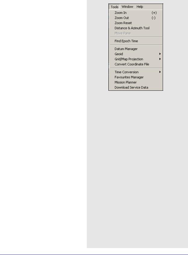
2.8 Tools Menu
2.8.1Zoom In & Zoom Out
The Zoom In and Zoom Out tools adjusts the viewing scope of the map, while the Zoom Reset brings the map back into the default view.
If you have a scroll-wheel on your mouse, you can use it to zoom in and out by scrolling forwards and backwards over the area of interest.
Right-clicking on the Map Window provides you with several options, including the ability to load a specific solution and to open the Feature Editor.
The Save to HTML option generates an HTML file containing a bitmap version of the Map Window. These HTML and BMP files are saved to the HTML folder contained within the project folder.
2.8.2Distance & Azimuth Tool
The first six options available all pertain to the
Map Window. The Distance & Azimuth tool allows for certain calculations to be made between epochs or stations. Click on the feature or epoch that you wish to measure from and then right-click on the feature or epoch that you want to measure to. The Distance and Azimuth window appears and shows the horizontal, surface, grid and spatial distances between the selected points. The azimuth and scale factor information are also displayed.
2.8.3Move Pane
This tool is only accessible once the map zooms in. This tool allows you to scroll the different parts of the map. To use this tool, click on the map and drag it in the desired direction.
2.8.4Find Epoch Time
This feature allows you to search the map for the epoch corresponding to a GPS time. Once found, the map zooms in and the epoch time is circled in red.
GrafNav / GrafNet 8.10 User Guide Rev 4 |
129 |

Chapter 2 |
GrafNav |
|
|
How to solve for a transformation or datum conversion
1.Isolate the ToDatum and the FromDatum to be used. Normally, one of the two will be WGS84, but ITRF is also common. This feature can be used to convert between any two datums and it does not matter which datum is which (From or To), as long as the coordinate files correspond.
2.Create a text file that contains the geographic coordinates of the points in the FromDatum. Examples include NAD83 and ED50.
Coordinate systems other than geographic (degrees minutes seconds) are not supported. The format for the coordinate file is as follows:
PointID [Ref Year] Lat_deg Lat_min Lat_sec Lon_deg Lon_min Lon_sec EllHgt Flag
Continued on the following page.
The PointID may not contain any spaces. The Lat_deg (latitude) term is positive for the Northern hemisphere and negative for the Southern. The Lon_deg (longitude) is positive for the Eastern hemisphere and negative for the Western. The EllHgt is in meters and is the height above the ellipsoid.
The Flag term is optional and indicates whether this point should be used for computing the transformation. Valid values are either 1 or 0, with 1 being assigned if the Flag is not present. Use the Flag to either prevent suspect points from corrupting the solution or to use some points as an independent check.
2.8.5Datum Manager
See Section 2.6.5, on Page 97 for information regarding the first three tabs. The two remaining tabs are discussed here.
Transform Coordinates
This tool transforms point coordinates from one datum to another. This is often used to transform base station coordinates of a project to another processing datum. You can select a point that is stored in the Favourites Manager to be converted and save any transformed point to Favourites.
Specifying the week number of the coordinate effects the final result if the conversion 14-parameter.
Solve Conversion
GrafNav can solve for a 3-, 7-, or 14parameter transformation. The 7-parameter can have the scale constrained to unity resulting in a 6- parameter transformation with 3 translations and 3 rotations. The 14-parameter transformation allows scale, scale rate, translation, velocity, rotation, and rotational rate to be solved. You can enable or disable individual parameters. Use this if you have a list of control points with coordinates in both datums. From these point pairs, a locally best-fitting datum transformation can be computed for the region or project area. The two lists must be in ASCII format and all points in each file must be common to both files, with identical point names. The order the points appear in each file is not important and ellipsoidal height values are required.
7 and 14-parameter transformations should only be used for areas greater than 300 km across because solving transformations over small areas makes the parameters very sensitive to coordinate errors.
14-parameter transformations require coordinates from the epochs in time, which is specified as epoch year in the second parameter.
In some cases, 7-parameter transformations are necessary due to a slope in the local datum. This is considered a very localized datum. See Section 9.10, on Page 285 for more information on datums.
130 |
GrafNav / GrafNet 8.10 User Guide Rev 4 |
GrafNav |
Chapter 2 |
|
|
|
|
Advanced Settings
Add computed conversion to Datum Conversion List
Adds the computed conversion to the list under the Datum Conversions tab. This allows the conversion to be used by the software.
Force scale factor to 1.0
Constrains the PPM scale to zero
(scale factor = 1). This is only applicable for the 7-.
Compare against existing conversion
Computes residuals for an another existing conversion in the Datum Conversions list. This is useful for determining if the newly computed conversion fits better than the existing one.
Processing Report
The following are contained in the processing report:
Parameters
Reflects the input options used for the computation.
Raw Differences
These are the raw differences between the ECEF coordinates of the matched points in the two files. Only points that have a match found are processed. The USED column indicates if points are to be used in the solution or not and refers to the Flag in the FromDatum file.
Transformation Parameters
Shows the parameters computed by the solve process. If a comparison is made, then this shows the parameters from the datum conversion. If the transformation needs to be inverted due to opposite From and To datums, then the reversed values are shown.
Residuals using …
Shows difference between raw FromDatum coordinates and the ToDatum coordinates transformed into the FromDatum. Root-mean- square values are shown at the bottom. Note that the residual values are oriented to local level (east, north and up).
Raw Differences
These are the raw differences between the ECEF coordinates of the matched points in the two files. Only points that have a match found are processed. The USED column shows if points are to be used in the solution or not and refers to the Flag in the FromDatum file.
How to solve for a transformation or datum conversion (cont.)
3.Create a text file corresponding to the ToDatum. The format for this file is the same as for the FromDatum, except that the Flag term is ignored. Be sure that the PointIDs match those in the ToDatum file that was created in the previous step.
4.Select Tools | Datum Manager. Click on the
Solve Conversion tab
5.Press Browse to select the coordinates file corresponding to the FromDatum.
6.Select the datum from the list. If the datum is not present, enable or add it. See Section 2.6.5, on Page 97 for more information.
7.Browse for the file corresponding to the
ToDatum.
8.Select the corresponding datum.
9.Select the transformation parameter type. Enter a meaningful Info string to appear in the datum conversion. It is helpful to put a comment in order to be able to distinguish this transformation from others later one.
10.Select an output file name. This file is a report that is generated from the computation process. It contains the computed transformation parameters along with the residuals.
11.(Optional) Click the Advanced Settings button. parameter transformation and effectively causes a 6-parameter transformation to be solved.
12.Select the Compute Transformation button. A message proclaiming success should appear afterwards. If not, act on the message. For some failures, a partial report file may be created.
13.Press the View button to view the processing report.
GrafNav / GrafNet 8.10 User Guide Rev 4 |
131 |

Chapter 2 |
GrafNav |
|
|
2.8.6 Geoid
Waypoint software supports the use of geoid files for orthometric heights. Waypoint’s software supports geoids in three different formats including the U.S. National Geodetic Survey’s GEO format, the Geodetic Survey of Canada’s BIN/SLV format, and Waypoint’s own WPG format.
When correcting ellipsoidal heights to produce orthometric heights, it is very important that the geoid and processing datums match. For example, if EGM-96 is used, then the base station coordinates should be in WGS84. This datum should also be used for processing. Use the same geoid model as used on the control sheets because it decreases differential.
The geographic boundaries are displayed within the applicable geoid. The number of rows and columns present in the grid used to define the geoid are also shown.
In some cases, you might want to process in a datum different than the one the geoid uses. To do this, use the geoid model in a relative fashion. The slope should be roughly the same between ellipsoids. Between NAD27 and NAD83, there is up to 200-metre difference in geographic coordinates. In areas with very high relief, this might result in a few centimeters of orthometric height error. The same can be said for other datums with large shifts like TOKYO and ED50.
In GrafNav, conversion to ellipsoidal height can be performed when entering the master coordinates. When exporting with Export Wizard, the geoid undulation is subtracted.
For GrafNet, the process is similar. This is because you can convert orthometric heights to ellipsoidal as you enter the control/check point coordinates.
Be sure to set the ellipsoidal/orthometric height flag correctly.
Elevations are always stored as ellipsoidal inside GrafNet. Conversion to orthometric only take place at time of coordinate export. In many cases, the default output is ellipsoidal height, so care should be taken when exporting elevation values.
132 |
GrafNav / GrafNet 8.10 User Guide Rev 4 |