

GrafNet |
Chapter 3 |
|
|
|
|
3.4Process Menu
3.4.1Processing Sessions
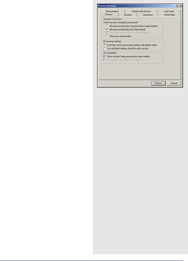
This option brings up the Process Sessions window, where a number of options pertaining to processing are available.
Process
Sessions to Process
Allows you to decide which session to process. The options are listed in the shaded box.
Processing Settings
Determines which processing settings to use for each baseline. The options are listed in the shaded box.l
On Completion
Defines actions to be taken when processing is completed. The following two settings are available:
Show sessions being processed in data window
Displays all processed sessions in the Data Manager window.
Run network adjustment on completion
Will automatically bring up the Network Adjustment window. See Section 3.4.6, on Page 165 for more information.
General Options
Process Direction
The direction can be set to Forward, Reverse, or Both directions. GrafNet uses the most recently created solution file. The forward and reverse solution should provide roughly the same solution but in some circumstances, a reverse solution passes when a forward has failed, or solutions may differ because of different base satellite selections. If both directions are selected, the combination of the two solutions will be used. See Section 2.5.3, on Page 91 for more information.
Sessions to process
All unprocessed
Processes all session listed as either Unprocessed or Approximate that is, blue or purple in Map Window.
All unsuccessful
Processes sessions that do not have a Good status that is, not green in the Map Window. Processing will start nearest to the control points and move outward. For processing problem sessions, it may be better to process through GrafNav.
Only those session shown in Data Manager
Will only process the sessions that are presently listed in the Data Manager window.
Reprocess entire project
Reprocesses all solutions, regardless of status. It is a good idea to reprocess all sessions after changing the global options.
Processing settings
Overwrite session processing settings with global values
Will apply the options set under Options | Global Settings to all baselines being processed. Any individual baselines whose settings were changed will have their settings overwritten.
Use individual settings stored for each session.
Will use the options as individually set for each baseline for processing.
GrafNav / GrafNet 8.10 User Guide Rev 4 |
159 |

Chapter 3 |
GrafNet |
|
|
Table 12: Processing Modes
|
|
|
Minimum |
Maximum |
Approximate |
|
Mode |
Freq. |
Observation |
Distance |
|
|
Accuracy |
||||
|
|
|
Time (min) |
(km) |
|
|
|
|
|
||
|
|
|
|
|
|
|
Fixed |
Single |
15 |
15 |
5mm + 1ppm |
|
Dual |
5 |
50 |
5mm + 1ppm |
|
|
|
||||
|
|
|
|
|
|
|
Float |
Single |
See Note 2 |
See Note 3 |
10mm + 2ppm |
|
|
|
|
|
|
|
Iono-free |
Dual |
See Note 2 |
See Note 3 |
10mm + 0.5ppm |
|
|
|
|
|
|
|
|
Single |
Chooses between Fixed and Float depending |
||
|
Auto |
on baseline distance. |
|
||
|
Dual |
Chooses between Fixed and Iono-free |
|||
|
|
||||
|
|
|
depending on baseline distance. |
||
|
|
|
|
|
|
|
|
|
|
|
|
1. Observation times should be increased for longer baselines. For single frequency, a good rule of thumb is 10 min + 1 min / km. For dual frequency, these times can be halved. Observation times should also be increased during poor satellite geometries that is, high PDOP.
2.No minimum time is given, but accuracy improves with observed time. A few minutes of observation will only achieve sub-metre accuracies under very good operating conditions.
3.For dual frequency receivers, use fixed or float solutions for baselines less than 50 km, and iono-free solutions for more than 50 km.
4.Accuracies are given for average occupation time. Accuracies will increase for longer times, and degrade with poor geometry or bad measurement quality.
5.Use precise ephemeris for baselines longer than 150 km. See Section 3.3.9, on Page 157 for information.
Static Solution Type
See Table 11 on Page 148 for information
Frequency
Defines the type of data used for processing. The following settings are available:
Single frequency
Forces single frequency (L1 only) processing
Dual frequency
Forces dual frequency processing. L1 / L2 data must be present in all observation files.
Automatic
Auto-detects single or dual frequency processing for each baseline. This is the default mode and should be used under most circumstances.
GPS / GLONASS Mode
Applies to data logged using GLONASSenabled receivers. The following settings are available:
Automatic
Enables the use of GLONASS data.
GPS only
Disables GLONASS processing. This option may be useful if GLONASS data is causing problems.
GPS+GLONASS
Forces the use of available GLONASS data. Should be used if automatic detection fails.
Elevation Mask
Satellites below this mask angle will be ignored. The default value is 15°. Lowering this value will allow more satellites to be used, possibly improving a solution with poor geometry.
Time Range
This option is only available for individual baselines by right-clicking on the session in the
Data Manager and selecting Options.
Interval
Allows you to choose the processing interval. The default interval is the interval at which the data was logged. If the logged data rate is high (1 Hz), override this interval with 15 seconds. Processing static data at intervals shorter than 15 seconds is not beneficial, will not improve accuracies and could result in overly optimistic accuracy estimates due to the high time correlation of carrier phase data.
160 |
GrafNav / GrafNet 8.10 User Guide Rev 4 |
GrafNet |
Chapter 3 |
|
|
|
|
Advanced Options
Satellite Omissions
See Satellite / Baseline Omissions in the Advanced Tab on Page 65 for more information.
Cycle Slip Settings
The settings are listed in the shaded box.
GrafNav / GrafNet Interface Settings
If you export baselines to GrafNav, the choices in the shaded box are available to specify how changes made to the processing settings in GrafNav affect those in GrafNet.
If you decide to have the processing settings in GrafNet updated to match those used in GrafNav, they will only be stored for the individual baseline that was exported. The global processing options for the GrafNet project are unaffected.
Fixed Static Options
See Section 2.5, on Page 61 for information regarding all the settings on this tab.
Measurement Options
See Section 2.5, on Page 61 for information regarding all the settings on this tab.
Cycle slip settings
Ignore satellite if tracked less than
See L1 carrier locktime cut-off in the Advance 1options tab on on Page 66 for more information.
L1 / Iono-free static cycle slip tolerance
See Static cycle slip tolerance in the Advance 1options tab on on Page 68 for more information.
L2 static cycle slip tolerance
See Small L2 cycle slip tolerance in the Advance 1 options tab on on Page 68 for more information.
Display cycle slip messages during processing
See Write cycle slips to message log in the Advance 1options tab on on Page 66 for more information.
Write individual satellite residuals to binary value file
See Write MB binary values / satellite residuals in the
Advance 1options tab on on Page 66 for more information.
GrafNav / GrafNet Interface Settings
Always update session settings
Any changes made to the processing settings in GrafNav will be saved to that baseline’s processing settings in GrafNet.
Never update
Any changes made in GrafNav will not be saved in GrafNet. As such, GrafNet will retain the settings that were used at the time of export.
Prompt user before update
You will be prompted after every processing run in GrafNav as to whether or not the processing settings used should be saved to GrafNet.
GrafNav / GrafNet 8.10 User Guide Rev 4 |
161 |
Chapter 3 |
GrafNet |
|
|
Minimum observation time for forming a session
Controls the minimum number of seconds necessary to declare concurrent observation files as a session. The default value is three minutes. For dual frequency data, this time can be reduced, while for single frequency data, this value may have to be lengthened to avoid short / low accuracy baselines.
Minimum time span for breaking up observations into periods
Controls the time required between sessions in order to have them recognized as two separate sessions. The default is three minutes. This gets used when observations are added to the project with the Break-up multiple occupations into periods option enabled in the Add Observations window. See Section 3.3.6, on Page 155 for more information.
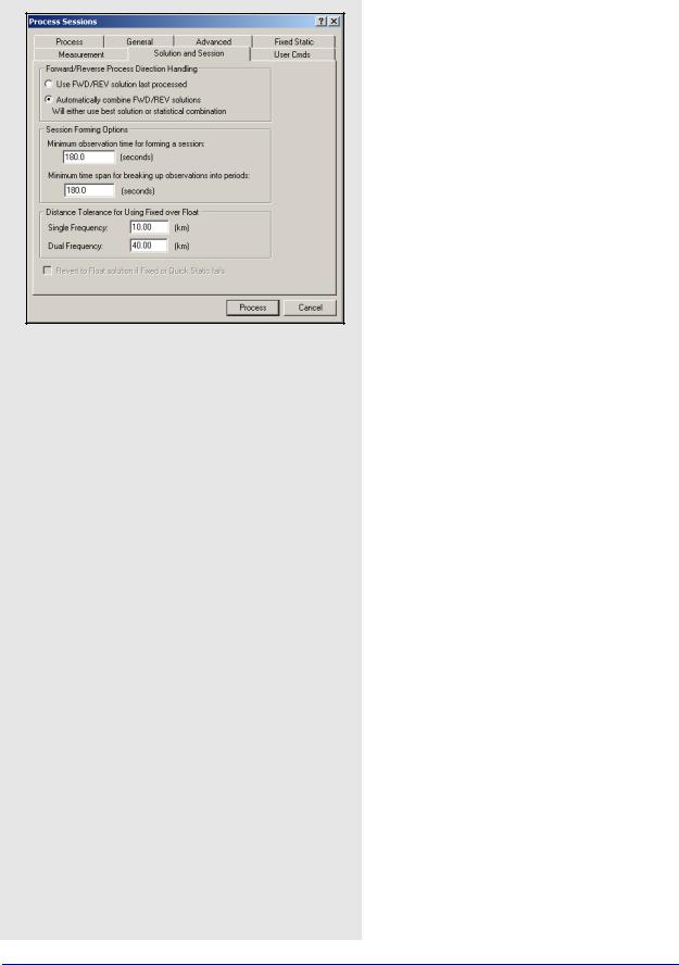
Solution and Session Options
Forward / Reverse Process Direction Handling
Allows you to change the way forward and reverse solutions are chosen for use in the network. By default, GrafNet will load the latest solution (most recently processed). However, if you want to use a combined solution, select the Automatically combine FWD / REV solutions option.
Session Forming Options
There are two settings available here:
Distance Tolerance for Using Fixed Over Float
This tolerance is used when you select Automatic for the Static Solution Type under the General tab. If the baseline distance is longer than the tolerance, then a float solution will be used for single frequency, while an iono-free solution will be used for dual frequency. Otherwise, the fixed static solution is used.
User Command Options
See User Cmds on Page 84 for more information on this tab. The list of available commands can be found in Appendix A on Page 296.
3.4.2 Rescanning Solution Files
This option rescans the FSS (forward static solution) or RSS (reverse static solution) files. When deciding between the forward or reverse, it will use the one most recently created. Under normal circumstances, solution scanning is automatic, but there are a few instances when you may want to rescan manually, such as when using GrafNav in conjunction with GrafNet.
3.4.3 Ignore Trivial Sessions
GrafNet defines trivial baselines as those that are unnecessary and result from multiple receivers simultaneously running. The problem with this is that the baseline solutions computed by GrafNet are correlated, and so they are dependent. Removing trivial baseline reduces these dependencies, while still maintaining a closed loop. It also creates a network where the standard deviations reflect the actual errors more accurately.
162 |
GrafNav / GrafNet 8.10 User Guide Rev 4 |
GrafNet |
Chapter 3 |
|
|
|
|
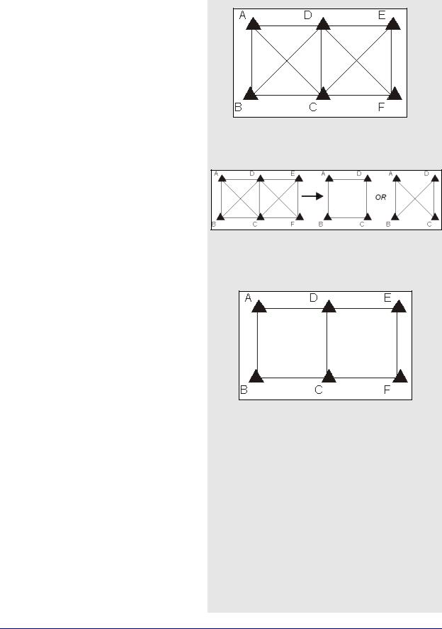
Consider the network in Figure 3. The six stations are surveyed with four receivers during two one-hour sessions. During the first session, stations A, B, C, and D are observed. During the second session, the points C, D, E, and F are observed.
This network can be divided in two sub-networks, formed by the first and second time periods. Before the trivial baseline removal, every baseline in these two sub-networks is dependent on the other baselines. These dependencies cause the loop ties to be low.
With four receivers or more collecting data at the same time, a sub-network is very over-determined. Using three GPS receivers, the network is still overdetermined, but all baselines need to be included to form a closed loop. GrafNet removes these dependent or trivial baselines by creating a single loop that connects all of the points in the sub-network. Figure 5, in the shaded box, illustrates that it is easy to remove these baselines.
With four receivers, there are two dependent baselines in each sub-network. GrafNet removes these trivial baselines for each sub-network. Figure 4 shows two possibilities of what GrafNet might do with the first sub-network.
GrafNet removes the trivial baseline by setting their session status to Ignore. It is possible to un-ignore any session by simply changing its status back to Unprocessed. GrafNet tries to keep the sessions that are of best quality. The following criteria is considered:
•The amount of time the baseline was surveyed
•The frequencies used in the surveying of the session
•The length of the baseline
•The number of connecting baselines to the two end-points
As shown in Figure 5, GrafNet automatically excluded AC, BD, CE, and DF. It then forms a single loop for each of the time periods. DC is a baseline with a duplicate session.
Figure 3: Trivial Baselines
Figure 4: Removal of Trivial Baselines
Figure 5: Network with Trivial Baselines Removed
GrafNav / GrafNet 8.10 User Guide Rev 4 |
163 |