

- •Table of Contents
- •Congratulations!
- •Scope
- •How to use this manual
- •Prerequisites
- •Conventions and Customer Service
- •What’s New!
- •Precise Point Positioning (PPP) processor
- •Software License
- •Warranty
- •Introduction and Installation
- •1.1 Waypoint Products Group Software Overview
- •1.2 Installation
- •1.2.1 What You Need To Start
- •1.2.2 CD Contents and Installation
- •1.2.3 Upgrading
- •1.3 Processing Modes and Solutions
- •1.4 Overview of the Products
- •1.4.1 GrafNav
- •1.4.2 GrafNet
- •1.4.3 GrafNav Lite
- •1.4.4 GrafNav / GrafNet Static
- •1.4.5 GrafMov
- •1.4.6 GrafNav Batch
- •1.4.7 Inertial Explorer
- •1.5 Utilities
- •1.5.1 Copy User Files
- •1.5.2 Download Service Data
- •1.5.3 GPS Data Logger
- •1.5.4 GPB Viewer
- •1.5.5 Mission Planner
- •1.5.6 Data Converter
- •GrafNav
- •2.1 GrafNav, GrafNav Lite and GrafNav / GrafNet Static Overview
- •2.2 Start a Project with GrafNav
- •2.3 File Menu
- •2.3.1 New Project
- •2.3.2 Open
- •2.3.3 Save Project
- •2.3.4 Save As
- •2.3.5 Print
- •2.3.6 Add Master Files
- •2.3.7 Add Remote Files
- •2.3.8 Alternate Precise / Correction Files
- •2.3.9 Show Master Files
- •2.3.10 Load
- •2.3.12 GPB Utilities
- •2.3.13 Remove Processing Files
- •2.3.15 Recent projects
- •2.3.16 Exit
- •2.4 View Menu
- •2.4.1 GPS Observations
- •2.4.2 Forward and Reverse Solutions
- •2.4.3 Processing History
- •2.4.4 Processing Summary
- •2.4.5 Return Status
- •2.4.6 Features
- •2.4.7 Objects
- •2.4.8 ASCII File (s)
- •2.4.10 Current CFG File
- •2.5 Process Menu
- •2.5.1 Process GNSS (differential)
- •2.5.2 Process PPP (single point)
- •2.5.3 Combine Solutions
- •2.5.4 Launch Batch Processor
- •2.5.5 Stop Auto Run
- •2.5.6 Load GNSS Solution
- •2.5.7 Load PPP Solution
- •2.5.8 Load Any Solution
- •2.5.9 Import Solutions and Setting
- •2.6 Settings Menu
- •2.6.1 GNSS Processing
- •2.6.2 PPP Processing
- •2.6.3 Coordinate
- •2.6.4 Individual
- •2.6.5 Datum
- •2.6.6 DEM Plotting
- •2.6.7 Photogrammetry
- •2.6.8 Manage Profiles
- •2.6.9 Compare Configuration Files
- •2.6.10 Preferences
- •2.7 Output Menu
- •2.7.1 Plot GPS Data
- •2.7.3 Plot Master / Remote Satellite Lock
- •2.7.4 Export Wizard
- •2.7.5 Write Coordinates
- •2.7.6 View Coordinates
- •2.7.7 Export Binary Values
- •2.7.8 Write Combined File
- •2.7.9 Build HTML Report
- •2.7.10 Export to Google Earth
- •2.7.11 Show Map Window
- •2.7.12 Processing Window
- •2.8 Tools Menu
- •2.8.1 Zoom In & Zoom Out
- •2.8.2 Distance & Azimuth Tool
- •2.8.3 Move Pane
- •2.8.4 Find Epoch Time
- •2.8.5 Datum Manager
- •2.8.6 Geoid
- •2.8.7 Grid/Map Projection
- •2.8.8 Convert Coordinate File
- •2.8.9 Time Conversion
- •2.8.10 Favourites Manager
- •2.8.11 Mission Planner
- •2.8.12 Download Service Data
- •2.9 Window Menu
- •2.9.1 Cascade
- •2.9.2 Tile
- •2.9.3 Next and Previous
- •2.9.4 Close Window
- •2.9.5 Close All Windows
- •2.10 Help Menu
- •2.10.1 Help Topics
- •2.10.2 www.novatel.com
- •2.10.3 About GrafNav
- •GrafNet
- •3.1 GrafNet Overview
- •3.1.1 Types of Networks
- •3.1.2 Solution Types
- •3.1.3 Computing Coordinates
- •3.2 Start a Project with GrafNet
- •3.2.1 Fix Bad Baselines
- •3.2.2 Unfixable Data
- •3.3 File
- •3.3.1 New Project
- •3.3.2 Open Project
- •3.3.3 Save Project
- •3.3.4 Save As
- •3.3.5 Print
- •3.3.6 Add / Remove Observations
- •3.3.7 Add / Remove Control Points
- •3.3.8 Add / Remove Check Points
- •3.3.9 Alternate Ephemeris / Correction Files
- •3.3.10 Remove Processing Files
- •3.3.11 Import Project Files
- •3.3.12 View
- •3.3.13 Convert
- •3.3.14 GPB Utilities
- •3.3.15 Recent projects
- •3.3.16 Exit
- •3.4 Process Menu
- •3.4.1 Processing Sessions
- •3.4.2 Rescanning Solution Files
- •3.4.3 Ignore Trivial Sessions
- •3.4.4 Unignore All Sessions
- •3.4.5 Compute Loop Ties
- •3.4.6 Network Adjustment
- •3.4.7 View Traverse Solution
- •3.4.8 View Processing Report
- •3.4.9 View All Sessions
- •3.4.10 View All Observations
- •3.4.11 View All Stations
- •3.5 Options Menu
- •3.5.1 Global Settings
- •3.5.3 Datum Options
- •3.5.4 Grid Options
- •3.5.5 Geoid Options
- •3.5.6 Preferences
- •3.6 Output Menu
- •3.6.1 Export Wizard
- •3.6.2 Write Coordinates
- •3.6.3 View Coordinates
- •3.6.4 Export DXF
- •3.6.5 Show Map Window
- •3.6.6 Show Data Window
- •3.6.7 Baselines Window
- •3.6.8 Processing Window
- •3.7 Tools Menu
- •3.8 Help Menu
- •GrafNav Batch
- •4.1 Overview of GrafNav Batch
- •4.1.1 Getting Started with GrafNav Batch
- •4.2 File Menu
- •4.2.1 New Project
- •4.2.2 Open Project
- •4.2.3 Save Project
- •4.2.4 Save As
- •4.2.5 Print
- •4.2.6 Add Baselines
- •4.2.8 Add Combined Baselines
- •4.2.9 Import CFG Files
- •4.2.10 Edit Selected Baseline Settings
- •4.2.11 Removing Selected Baselines
- •4.2.12 View ASCII Files
- •4.2.13 View Raw GPS Data
- •4.2.14 Convert GPS Data
- •4.2.15 GPB Utilities
- •4.2.16 Remove Process Files
- •4.2.17 Recent Projects
- •4.2.18 Exit
- •4.3 Process Menu
- •4.3.1 Process All Baselines
- •4.3.2 Process Selected
- •4.3.3 GrafNav on Selected Baselines
- •4.3.4 View Selected Processing Summary
- •4.3.5 Load All Solutions
- •4.3.6 Load Selected Solutions
- •4.4 Settings Menu
- •4.4.1 Global
- •4.4.2 Selected
- •4.4.3 Copy Processing Options
- •4.4.4 Load into Selected From
- •4.4.5 Manage
- •4.4.6 Preferences
- •4.5 Output Menu
- •4.5.1 Plot Selected GPS Data
- •4.5.2 View Selected Map
- •4.5.3 Export All
- •4.5.4 Export Selected
- •4.6 Tools Menu
- •4.7 Windows
- •4.8 Help Menu
- •GrafMov
- •5.1 Overview of GrafMov
- •5.2 Getting Started with GrafMov
- •5.3 File Menu
- •5.3.1 Add Master File
- •5.4 View Menu
- •5.5 Process Menu
- •5.6 Setting Menu
- •5.6.1 Moving Baseline Options
- •5.7 Output Menu
- •5.7.1 Plot GPS Data
- •5.8 Tools Menu
- •5.9 Interactive Windows
- •5.10 Help Menu
- •AutoNav
- •6.1 Overview of AutoNav
- •6.2 Getting Started with AutoNav
- •6.3 Base Station Files
- •6.4 Remote Files
- •6.5 Interactive Windows
- •File Formats
- •7.1 Overview of the File Formats
- •7.2 CFG File
- •7.3 GPS Data Files
- •7.3.1 GPB File
- •7.3.2 STA File
- •7.3.3 Old Station File Format
- •7.3.4 EPP File
- •7.4 Output Files
- •7.4.1 FML & RML Files
- •7.4.2 FSS & RSS Files
- •7.4.3 FWD & REV Files
- •7.4.4 FBV & RBV Files
- •Utilities
- •8.1 Utilities Overview
- •8.2 GPB Viewer Overview
- •8.2.1 File
- •8.2.2 Move
- •8.2.3 Edit
- •8.3 Concatenate, Splice and Resample Overview
- •8.3.1 Concatenate, Splice and Resample GPB Files
- •8.4 GPS Data Converter Overview
- •8.4.1 Convert Raw GPS data to GPB
- •8.4.2 Supported Receivers
- •8.5 GPS Data Logger Overview
- •8.5.1 Getting Started with WLOG
- •8.5.2 File
- •8.5.3 Display
- •8.5.4 Plot
- •8.5.5 Zoom Menu
- •8.5.6 Events Menu
- •8.6 WinCE Data Logger Overview
- •8.6.1 Installing CELOG
- •8.6.2 Getting Started with CELOG
- •8.6.3 Variable Display File
- •FAQ and Tips
- •9.1 Overview of FAQ and Tips
- •9.2 General FAQ and Tips
- •9.2.1 How can I store Master Station Coordinates?
- •9.2.2 How can I obtain Master Station Coordinates?
- •9.2.3 How can I customize output formats?
- •9.2.4 How can I download base station data?
- •9.3 Kinematic Processing FAQ and Tips
- •9.3.2 Should I combine forward and reverse solutions?
- •9.3.3 How can I use static / kinematic flags?
- •9.3.4 How do I eliminate problem satellites?
- •9.3.5 How do I set the measurement standard deviations?
- •9.3.6 How do I control bad data?
- •9.3.7 How do I avoid missing epochs?
- •9.3.8 Should I avoid using RINEX for kinematic data?
- •9.3.9 How do I process kinematic data logged during an ionospheric storm?
- •9.3.10 How do I process long kinematic baselines?
- •9.4 Integer Ambiguity Determination Tips
- •9.4.1 How can I detect and fix incorrect integer fixes?
- •9.4.2 How can I help KAR/ARTK find a solution?
- •9.4.3 How can I use KAR and ARTK to improve poor combined separations?
- •9.5 Static Processing FAQ and Tips
- •9.5.1 Can I use GrafNet for static batch processing?
- •9.5.2 Can I use kinematic processing on static baselines?
- •9.5.3 Using KAR or ARTK in GrafNet
- •9.5.4 How can I optimize the fixed static solution?
- •9.5.5 How can I refine L1/L2 integer solutions?
- •9.5.6 Can I use a larger interval for static processing?
- •9.5.7 How do I process static data logged during ionospheric storms?
- •9.5.8 How do I process long static baselines?
- •9.6.1 How should I choose a processing mode?
- •9.6.2 How important are base station coordinates?
- •9.6.3 How can I use the MB Plots?
- •9.6.4 How do I select a data interval?
- •9.6.6 How should I decide which base stations to use?
- •9.6.7 How do I deal with problematic baselines?
- •9.6.9 How can I use the fixed static solution?
- •9.6.10 What is the best way to process data with large base to rover separations?
- •9.6.11 How can I speed up processing?
- •9.7 PPP (Precise Point Positioning)
- •9.7.1 What is Precise Point Positioning?
- •9.7.2 How does PPP differ from differential processing?
- •9.7.3 How accurate is PPP?
- •9.7.4 What is PPP used for?
- •9.7.5 Who should use PPP?
- •9.7.6 Are there any limitations to PPP?
- •9.8 Common Inquiries
- •9.8.1 How can I determine the quality of a final solution?
- •9.8.2 How do I copy user files?
- •9.8.3 How do I update manufacturer files?
- •9.8.4 How do I produce local coordinates?
- •9.8.5 How do I define a local cartesian coordinate system?
- •9.8.6 How do I define a local coordinate grid?
- •9.8.7 How do I process an aerial survey with camera event marks?
- •9.9 Digital Elevation Models (DEM) FAQ and Tips
- •9.9.1 Why would I use a DEM?
- •9.9.2 What are the DEM sources?
- •9.9.3 What DEM formats are supported by GrafNav?
- •9.9.4 How do I handle large DEMs?
- •9.10 Datum FAQ and Tips
- •9.10.1 What are the available datums - related features?
- •9.10.2 How are datums handled within the software?
- •9.10.3 How do I make additional datums available?
- •9.10.4 How do I enter a 7-parameter transformation?
- •9.10.6 How do I use NADCON conversion files?
- •9.10.7 How do I prevent corruption from conversion errors?
- •9.11 Projections FAQ and Tips
- •9.11.1 What features are available with map projections?
- •9.12 Geoid FAQ and Tips
- •9.12.1 What are the available geoid - related features?
- •9.12.2 How can I create a WPG file?
- •A: Output Variables
- •B: Antenna Measurements Diagram
- •C: Summary of Commands
- •Index

Utilities |
Chapter 8 |
|
|
|
|
8.5GPS Data Logger Overview
All of Waypoint’s software packages include WLOG, a WIN95/98/2000/XP/NT data logger that supports various receivers from NovAtel, Ashtech/Thales, Trimble, CMC, Rockwell Jupiter, Javad/Topcon, Parthus, CSI, Navcom, Garmin, and Ublox. See Table 2 on Page 29 for more information on supported receivers.
WLOG configures the GPS receivers, logs the measurement data, and converts it into Waypoint’s proprietary format. Adjunct features include waypoint navigation, as well as satellite and scatter plotting capabilities. In addition, stations and events can be marked and written to STA files, which are compatible for post-processing in Waypoint’s software.
8.5.1Getting Started with WLOG
This section examines all the steps required to begin logging data through WLOG by analyzing each screen encountered when creating a new project.
How to log data with WLOG
1.Select File | New Project and give the project a name. Click Next.
2.Select the appropriate receiver type.
3.Select an interval at which to record the data.
4.Specify the COM port that is being used on the receiver to send the data.
5.For camera marks, enable the Request Camera Marks option.
This option is only available for use with NovAtel, Ashtech and Javad receivers
6.Enable the Re-compute Position option to force WLOG to output positions at the interval specified in Step 3. This alleviates the issue concerning receivers that only output position records on specific intervals.
Users of NovAtel and Ashtech receivers have the option to send ASCII commands to the receiver. This feature can be used to either disable commands or over-ride various receiver commands. Refer to the receiver manual for information on such commands.
7.Click Next.
8.If the GPS receiver is sending the data directly to the COM port of the computer, select Serial Port under Receive Data by and proceed to Step 9. If the data is being received over a network, select TCP/IP Network and proceed to Step 12.
GrafNav / GrafNet 8.10 User Guide Rev 4 |
247 |

Chapter 8 |
Utilities |
|
|
|
|
|
|
|
|
|
|
How to log data with WLOG cont.
9.If using serial communication to obtain data from the GPS receiver, specify the computer COM port to which the receiver is connected to.
Choose an appropriate baud rate from the list. The baud rate must be compatible with that of the receiver, and must take into account the amount of data being received that is, size of data records, data logging rate, and so on. Consult the receiver’s manual.
10.Select the parity. For most receivers, None should be selected. Consult the receiver’s manual.
11.Select the bits. For most receivers, Eight should be selected. Consult the receiver’s manual. Click Next. Proceed to Step 15.
12.If receiving the data by TCP/IP, specify the network protocol and the port number to be used.
13.If using MultiCast protocol, type in the group IP address.
UDP and MultiCast protocols are ideal for communication over local networks that are within the same office, while TCP is recommended for widearea communication. Be sure to select a port number that does not conflict with those reserved for standard network purposes. In general, numbers starting at 1024 are usually safe. For MultiCast groups, both the sender and the receiver must have the same IP address. For Win32, MultiCast IP addresses range from 224.00.00.00 to 240.00.00.00.
14. Click Next.
248 |
GrafNav / GrafNet 8.10 User Guide Rev 4 |
Utilities |
Chapter 8 |
||
|
|
|
|
|
|
|
|
|
|
|
|
How to log data with WLOG cont.
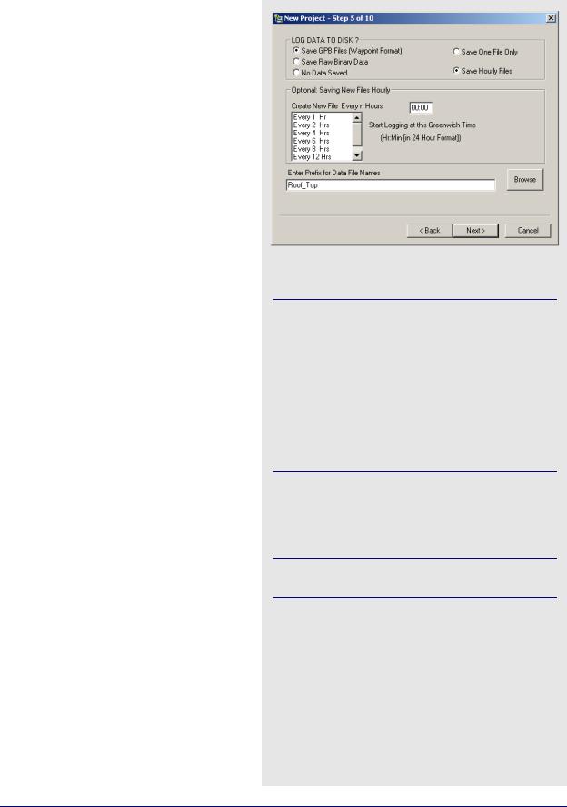
15. Select how the data will be saved.
Data can be saved byte-by-byte into a binary file. The entire session will be saved into one LOG file, which will have to be converted into GPB format before being post-processed.
Most users will find it preferable to log directly into Waypoint’s proprietary format, because it saves the trouble of converting the data later on when it is time for post-processing. This option also allows for the flexibility of breaking up the data into separate files of n hours.
16.Any data being saved to disk will be given the filename specified under Enter Prefix for Data File Names. The file extension is dependent on the selection made in Step 15.
Files being created every n hours will be given unique suffixes.
17. Click Next.
GrafNav / GrafNet 8.10 User Guide Rev 4 |
249 |

Chapter 8 |
Utilities |
|
|
|
|
|
|
|
|
|
|
How to log data with WLOG cont.
18.You have the option to select Output RTCM-104 Corrections, which are the updated differential corrections. This option must be enabled for the corrections to be displayed.
19.Select the desired type of RTCM output and the interval for each of the following:
Type 1: includes time, PRN, δρ and δρ rate.
Type 2: has the last IODE (issue of data ephemeris).
Type 3: gives position
Select the COM port to use for the RTCM output, and enter the coordinates at the base station antenna. Finally, select the baud rate.
20. Click Next.
250 |
GrafNav / GrafNet 8.10 User Guide Rev 4 |
Utilities |
Chapter 8 |
||
|
|
|
|
|
|
|
|
|
|
|
|
How to log data with WLOG cont.
21.Enable the RE-Broadcast Data over Network to rebroadcast GPS data collected by direct link to the GPS receiver over a local or wide-area network.
This allows two different computers in different locations can collect data from one GPS receiver and view that data in real-time, even though only one computer is directly linked to the receiver. This technique can be used to re-broadcast data using TCP protocol over existing internet connections.
22.Click Next.
23.Enter a port number to send out NMEA strings from a secondary serial port of the computer.
This would be useful in the case where some external device, such as an echo sounder, requires position input from GPS on its serial port.
24. Click Next.
GrafNav / GrafNet 8.10 User Guide Rev 4 |
251 |
Chapter 8 |
Utilities |
|
|
|
|
|
|
|
|
|
|
How to log data with WLOG cont.
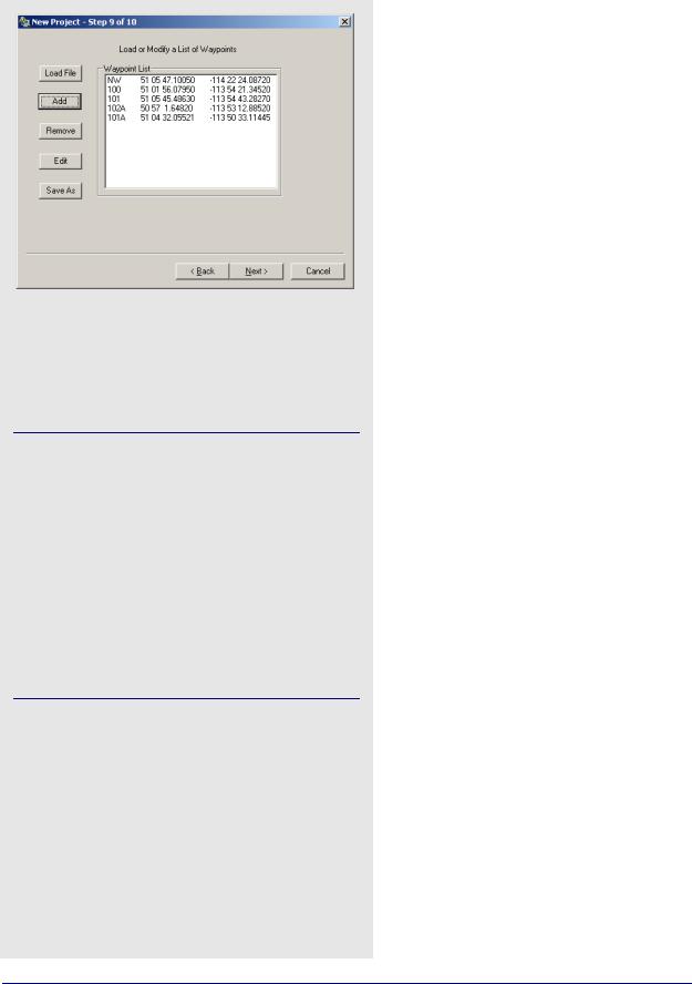
25.If navigating with a roving receiver, input a list of waypoints for navigation is useful because WLOG will provide a text and graphical display of the distance and bearing from the current GPS location to the selected waypoint.
WLOG also displays across and along-track information for navigation between any two selected waypoints.
Waypoints can be added in the following two ways:
1.An ASCII file can be loaded, as long as it is formatted correctly. The first element is a station name, followed by latitude and longitude, both in degrees minutes seconds. These fields must be space-delimited.
2.Waypoints can be added the Add button. These waypoints can be edited, removed, or saved to a file of their own for later use.
26.Click Next.
252 |
GrafNav / GrafNet 8.10 User Guide Rev 4 |