

Chapter 6 |
AutoNav |
|
|
6.4 Remote Files
AutoNav also requires that the remote files be specified before processing can begin.
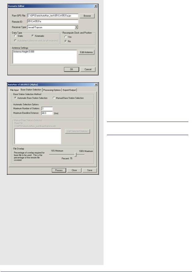
The entire remote file will be used for processing, as a time range cannot be specified. The Remote Files box provides a way of adding or removing remote files, or editing any existing ones.
When adding remote files with the Browse button, you are not limited to GPB files. AutoNav will automatically convert data from any of the supported receivers before processing. If the receiver type is known, it should be specified under
Receiver Type. Otherwise, select Unknown/ AutoDetect to have the program attempt to identify the receiver type automatically. If the file has already been converted to Waypoint’s proprietary format, select WAYPOINT GPB.
If raw data files are being added, indicate whether the file is of static or kinematic nature. There is also an option available for the recomputing of clock and position records.
Remote positions are required for automatic base selection.
Regardless of the data type, the antenna settings should be provided if possible. See Section 2.3.6, on Page 36 for information regarding antenna models.
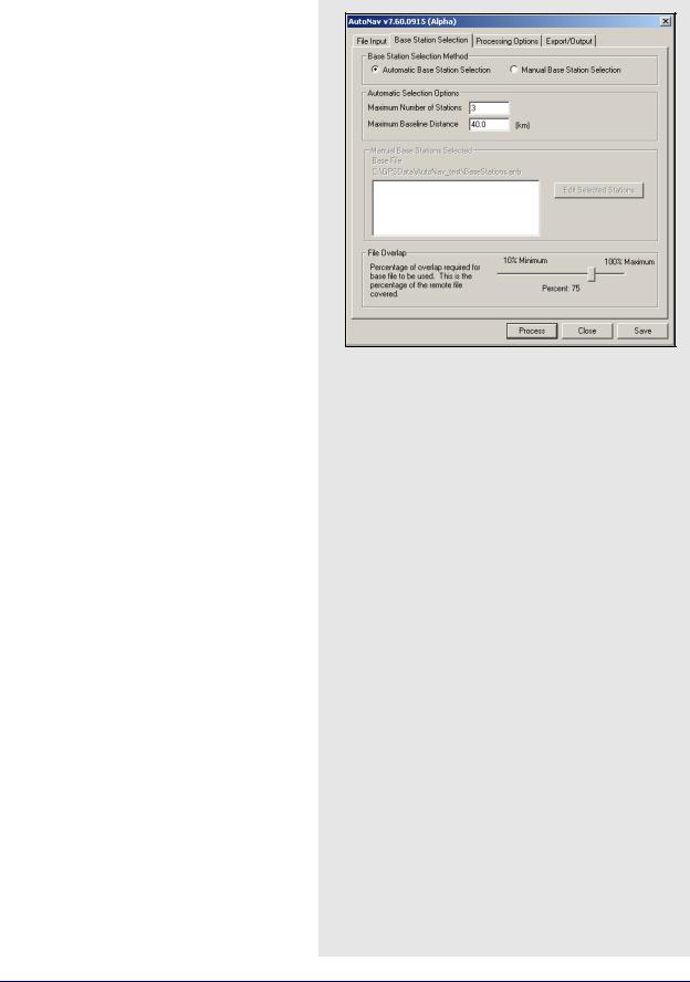
Base Station Selection
This tab contains settings to determine which of those stations within the previously selected ANB file are used for processing.
Base Station Selection Method
You have the choice between allowing the program to automatically select which base stations to use, or choosing them manually.
Automatic Base Station Selection
When this option is chosen, the software will use the constraints in the Automatic Selection Options box to determine which stations to include. Priority is given to those stations which are closest to the averaged coordinates of the remote file.
Manual Base Station Selection
This option gives you the power to enable or disable any base stations in the ANB file you see fit.
202 |
GrafNav / GrafNet 8.10 User Guide Rev 4 |
AutoNav |
Chapter 6 |
|
|
|
|
In either case, if an Internet base station is chosen from the ANB file, the software will automatically download the data for the day(s) of interest and concatenate and/or splice it, keeping only the data required for overlap with the remote file. Furthermore, the program will also resample any Internet or file base station data to the same interval as the remote file.
Automatic Selection Options
These settings are only available for those users who have opted for Automatic Base Station Selection. The values entered here govern the program’s choice of base stations for processing. Limit the total number of base stations allowed in the project with the Maximum Number of Stations setting.
A maximum of eight base stations can be included in any given project. However, only those stations that are within the Maximum Baseline Distance are included.
Manual Base Stations Selected
This box is only available if you have selected the
Manual Base Station Selection option. The currently loaded ANB file is displayed above the window, and the Edit Selected Stations button gives you access to the list of base stations included within it. From here, enable or disable base stations, as deemed necessary. All enabled base stations appear in the window.
File Overlap
This setting acts as an additional constraint in the base station selection process. It requires that any given base station overlap with the remote by the specified percentage before being allowed in the project. This setting applies primarily to file base stations since Internet base station data is automatically downloaded to overlap the entire remote file. This setting acts as a safety check to help ensure that the bulk of the remote file’s data will be processed.
GrafNav / GrafNet 8.10 User Guide Rev 4 |
203 |
Chapter 6 |
AutoNav |
|
|
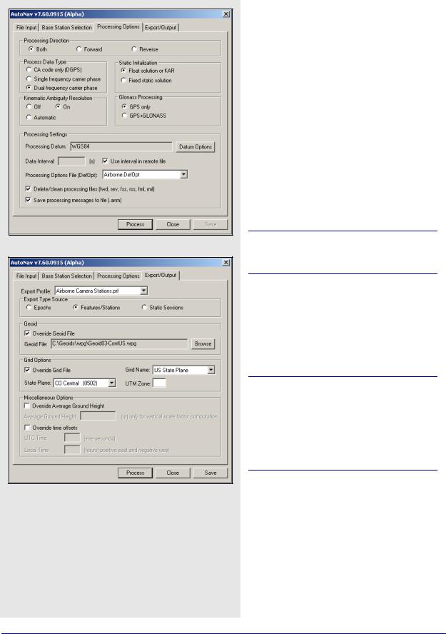
Processing Options
The options available on this tab pertain to the differential processing of the data. Only those options not previously discussed in Section 2.5, on Page 61 will be described here.
Processing Settings
Delete/clean processing files
This option forces the program to delete all of the listed file types upon completion of processing.
Save processing messages to file
This option ensures that the ANM file is stored to disk once processing is finished. This file contains all the messages displayed in the AutoNav Processing window. The ANM file can be very useful for troubleshooting any problems which may occur.
You cannot specify a time range for processing and, therefore, the entire remote file will be used.
Export/Output
The Export/Output tab allows you to control the parameters pertaining to the creation of the output file that is written once processing is complete.
See Section 2.7.4, on Page 111 for information regarding the settings available here.
The output file created will be given the same name as the project. The file extension, however, is dependent on the Export Profile selected.
The Geoid, Grid and Miscellaneous Options must be set if the selected profile requires these parameters for input.
204 |
GrafNav / GrafNet 8.10 User Guide Rev 4 |

AutoNav |
Chapter 6 |
|
|
|
|
6.5Interactive Windows
AutoNav Processing
Once the project has been successfully set up, and the Process button clicked, the AutoNav Processing window appears to keep you informed on the status of the program.
Processing Information
The Remote field in this box indicates which remote file is currently being processed. The Stage field indicates which step the program is at. The Information field indicates how many base stations are being used for processing.
The Messages window contains information being relayed from the program. Before processing begins, this window displays messages to inform you the current stage of the program is at. For example, if data is being obtained from the Internet, the percentage of data downloaded will be displayed.
Once downloading is complete, additional messages appear regarding the decompression and interpolation of the data. Once processing has started, this window echoes all the messages appearing in the Processing Window, called from GrafNav. All the messages displayed here are stored in the ANM file, and can be saved to disk under the Processing Options tab. This file should be consulted if any problems arise during processing.
Processing List of Remotes
This window displays the list of remote files to be processed, along with a status indicator to inform you whether or not processing has been successfully completed.
GrafNav / GrafNet 8.10 User Guide Rev 4 |
205 |

Chapter 6 |
AutoNav |
|
|
206 |
GrafNav / GrafNet 8.10 User Guide Rev 4 |