


Chapter 2 |
GrafNav |
|
|
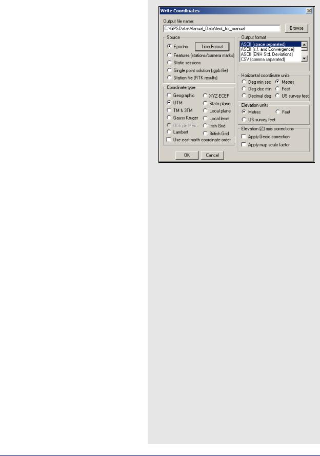
2.7.5 Write Coordinates
Write Coordinates is the old way of exporting coordinates and is retained only for backward compatibility. You are urged to use the Export Wizard, as it has more grid, datum and transformation options and is much more user-friendly.
Output File Name
Type in a name for the file that stores the output.
The program automatically assigns the extension.
Source
The following options are available:
Epochs
Outputs information for every epoch gathered by the GPS receiver.
Features
Only outputs information for stations or features, as marked in the STA file.
Static sessions
Outputs the final solution for each individual static occupation separated by kinematic occupation.
Single point solution
No longer supported.
Station file (RTK results)
Time Format - define the format of the time output. The format used for the time and time zone correction output can be adjusted in the window. If you are looking for UTC time, you can enter the offset here.
Correct time for receiver clock bias - applies the receiver clock bias to the GPS time. This corrects the time to the actual time that the receiver made the measurement. This correction can be as high as 1 millisecond and can be very significant in applications that require time synchronization between various instruments and devices.
Missing Epochs - linearly interpolates positions for missing epochs based on existing epochs.
122 |
GrafNav / GrafNet 8.10 User Guide Rev 4 |
GrafNav |
Chapter 2 |
|
|
|
|
Coordinate Type
Allows you to choose which grid to use for coordinate output. Depending on the selection made, you might be prompted for supplementary information. See Section 2.8.7, on Page 133 for details.
Output Format
The following formats are available:
ASCII
Data will be delimited by spaces. Scale factor and convergence information pertaining to the projection selected is available for output in this format. The standard deviations for the ENH positions can also be outputted, as well as the position with the distant-dependent component.
CSV (for EXCEL)
Data delimited by commas.
Waypoint OutRec (.CMB)
Prints a standard combined solution file. Also available via the Output menu.
INS/GPS Integrator
Produces a file with all data that would be useful in the integration of GPS with INS.
Itres Research data format
GeoRearch’s MSS
Data specially configured to be read by
GEOLINKTM.
Epoch Statistics (.dat file)
The epoch statistics generates a comma separated DAT file, containing the following information:
•Time
•Quality Factor
•DD_DOP
•L1 Phase RMS
•CA Code RMS
•Ambiguity Drift
•Standard Deviation
•PPM Trace
•Number of Satellites
Local Level Vector
Outputs local level positions and velocities, standard deviation and quality factor.
GrafNav / GrafNet 8.10 User Guide Rev 4 |
123 |
Chapter 2 |
GrafNav |
|
|
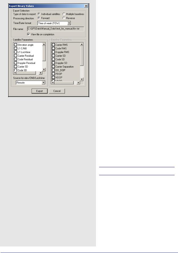
Export Selection options
Type of data to export: Select whether values for each satellite should be exported or for each baseline (MB processing only).
Processing direction: For processing values, forward or reverse values can be exported. For GPB values, forward or reverse produce the same result.
Time/Date format: A number of time outputs are possible. See Section 2.7.4, on Page 111 for more information on each format
File name: Displays the name of the file.
For GPB based values like L1 C/N0 and L1 Locktime, select whether to export the data from the base or rover files.
See Section 2.7.4, on Page 111 for a description of the available individual export values.
Horizontal Coordinate Unit
The units available for horizontal output will be dependent on the selection made under Coordinate Type.
Elevation Coordinate Units
The units available for elevation output, ellipsoidal or orthometric, are listed here.
Elevation Axis Corrections
See Section 2.7.5, on Page 122 for information on the two options available here.
2.7.6 View Coordinates
This allows you to view the coordinate files created by the Write Coordinates or Export Wizard features. If several output files have been created, this feature loads the most recent.
2.7.7 Export Binary Values
For GPS processing, the binary value (FBV/RBV) files contain additional statistics about each satellite and/or baseline. For MB processing, these files are automatically created. For single baseline processing, their creation requires that the Write MB binary value/satellite residuals option be enabled under the Advanced 1 tab of the processing options. See Advanced 1 Options on Page 66 for more information. Plot these values with the MultiBase Statistics and Individual Satellite Statistics plots under Output | Plot GPS Data. To work further with these values, use this option to convert FBV/RBV files to ASCII. Satellite locktime and C/ N0 values can also be exported from a GPB file in this way.
A solution must be loaded.
Export Selection
The options available are listed in the shaded box.
2.7.8 Write Combined File
This feature writes the combined trajectory to disk in a format similar to that described in Section 7.4.3, on Page 219 . This combined file represents the weighted combination of the two solutions currently loaded in the project, usually the forward and reverse. It can, in turn, be loaded directly by the software, allowing for the comparison of solution files obtained using varying processing options.
124 |
GrafNav / GrafNet 8.10 User Guide Rev 4 |
GrafNav |
Chapter 2 |
|
|
|
|
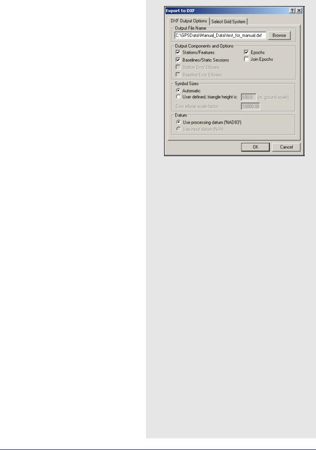
Export DXF
DXF is a file format read by various CAD packages. This utility outputs your project into DXF format.
Output File Name
Specify the name and path of the DXF to be created.
Output Components and Options
The following options are available:
Stations/Features
Outputs any stations or features loaded.
Baselines/Static Sessions
Outputs baselines between all the static sessions. The colour of the baselines will be the same as it appears in GrafNav and is determined by the quality factor.
Epochs
Outputs the trajectory and is only useful for kinematic data. Colour is determined by the quality factor.
Join Epochs
Joins a line between epochs.
Symbol Sizes
These settings govern the size of the features and stations in the DXF file. Automatic is suggested for a trial.
Datum
Allows you to choose between the processing datum or the input datum.
The grid options are available under the Select Grid System tab. For UTM, State Plane or any other zone-dependent grid, check that the zone number is correct because the default is likely wrong.
2.7.9Build HTML Report
Creates an HTML file containing a bitmap version of any plot that is currently open, including the Map Window. These HTML and BMP files are saved to the HTML folder contained within the project folder. The HTML file also contains information regarding the processing run(s) used to generate the plots.
2.7.10 Export to Google Earth
These options are listed in the shaded box.
Export to Google Earth Options
Export and View
Writes out a KML/KMZ file and loads it into Google Earth. This feature opens Google Earth.
Export Only
Writes out a KML/KMZ file to disk, but does not load it into Google Earth. If an auto-update entry has been previously created, then the newly written KML/KMZ records are updated in Google Earth.
Create Auto-Update Entry
Creates a network link within Google Earth which scans the project KML/KMZ file every 15 seconds for changes. This option can be used along with the
Export Google Earth file option under Settings | Preferences to completely automate the writing and loading of KML/KMZ files. See Section 2.6.10, on Page 102 for more information.
For additional customization of the Google Earth output files produced by the software, please see
Section 2.6.10, on Page 102 .
GrafNav / GrafNet 8.10 User Guide Rev 4 |
125 |