


GrafNet |
Chapter 3 |
|
|
|
|
3.3File
3.3.1New Project
To process a network for the first time, you must start a new project, which is done via File | New Project. GrafNet’s project configuration files carry a GNT extension.
3.3.2Open Project
To open an existing project, follow the steps in the shaded box.
3.3.3Save Project
The program automatically saves the project file (GNT), the Session Report (REP) and Traverse Solution (TRV) files before processing. Any changes made to the observations like name or antenna height are also saved.
3.3.4Save As
Use the Save As command under the File menu to create a new project that has identical processing options as the current project. This allows you to change the options in the new project and process the data without losing the solution computed by the original configuration.
3.3.5Print
This option allows you to print different windows.
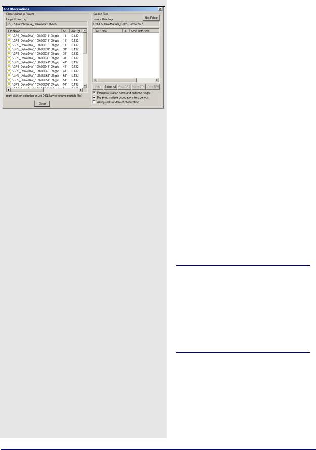
3.3.6Add / Remove Observations
This feature adds observation files to GrafNet projects. These files must be converted to GPB files using File | Convert | Raw GPS to GPB. GPB files are already created if you used Waypoint's data logging software and choose to log into GPB format.
GrafNet extracts the station name and antenna height values from the STA file, which is created during the conversion process.
How to open a project
1.Choose Open Project from the File menu.
2.Choose the name of the project from the dialogue box that appears asking you to select the name of an existing project (GNT file).
3.Click Open.
GrafNav / GrafNet 8.10 User Guide Rev 4 |
155 |
Chapter 3 |
GrafNet |
|
|
Station Name and Antenna Height
Verify that these values are correct and disable the option Prompt for station name and antenna height to add observations without user input. Double-check station names and antenna heights in the
Observations in Project list. Correct errors by rightclicking the observation and selecting Edit.
Antenna Profiles
GrafNet lets you select an antenna profile. Because additional offsets to the L1 and L2 phase centres are added, when using profiles other than Generic, match up the antenna height measurement to the expected measuring mark on the antenna. See Section 2.3.6, on Page 36 for help. If a slant measurement is selected, then a correction is applied based upon the size of the antenna ground plane. Be sure that the origin, know as the measuring mark, is defined.
Observation Files
Adding observations breaks observation files into multiple periods if a gap of 3 minutes or more is detected. This is controlled with Break-up multiple occupations into periods. Some RINEX files have gaps but are observed over the same point for the entire observation period so disable this option. For cases where the time gap is very short because the station-to-station movement is very fast, control the minimum time gap for breaking up periods with the
Solution and Session tab, under Options | Global Settings. Look for the Minimum time span for breaking up observations into periods.
Station IDs must match those of all observations for a given station and those of matching ground control points. Reprocess sessions associated with an observation if the antenna height has been changed. This is performed by right-clicking on the station for that observation and selecting Remove Processing Files. Then, select Reprocess entire project under Process | Process Sessions.
156 |
GrafNav / GrafNet 8.10 User Guide Rev 4 |
GrafNet |
Chapter 3 |
|
|
|
|
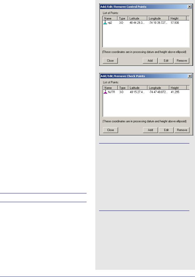
3.3.7Add / Remove Control Points
Add at least one horizontal ground control point before processing. Sessions will not be processed unless they are connected to a control point. The three types of control points include the following:
•3D: constrained horizontally and vertically
•2D: constrained horizontally
•1D: constrained vertically
After selecting Add / Remove Control Points from the
File menu, click Add to enter a new control point or Edit to adjust the station, position or Datum of a control point. The station ID should match that of the corresponding station.
Standard deviations can be entered at this stage. The default values are 5mm for horizontal and 5mm for vertical. You can change them to more realistic values. Standard deviations are only taken into account in the network adjustment. They are useful for combining high and low accuracy control points.
3.3.8Add / Remove Check Points
Check points are useful for gauging how well the network fits the existing control fabric. They are added in the same manner as control points, except that standard deviations cannot be defined. It is important that the processing datum matches the coordinates' datum.
3.3.9Alternate Ephemeris / Correction Files
Adds additional precise or broadcast ephemeris files (SP3 / SP3c and EPP files). See Section 2.3.8, on Page
38for more information.
Be sure that the entire span is covered.
The latitude and longitude coordinates should be in the same datum as the selected datum. The height can be entered as meters above the ellipsoid or above mean sea level. If height above mean sea level is used, you will have to select a geoid file. If a mean sea level, or orthometric, height is entered here, then only an approximate geoid correction is applied. As stations become more distant from the control point, orthometric height errors will increase. If more than one control point is present, and orthometric heights are entered, the height ties may be poorer as well.
GrafNav / GrafNet 8.10 User Guide Rev 4 |
157 |

Chapter 3 |
GrafNet |
|
|
Two conversion utilities available with File | Convert
Raw GPS to GPB
Users who have logged their data without using Waypoint’s logging software will have to convert their files to GPB format in order to process them with the software. More information on this utility is available in Chapter 7.
GPB to RINEX
Users who wish to produce a RINEX file from their GPB files may do so using this utility. This utility supports the creation of Version 2.0 and 2.1 of the RINEX format. For additional information, see Chapter 7 on Page 207.
3.3.10 Remove Processing Files
This feature can be used to clean up a directory by removing the session-dependent files. Solutions for static sessions are stored in the FSS for forward and RSS for reverse processed files. The FWD / REV and FML / RML files are unnecessary and can be removed. Selecting All Files removes all files including the solution files. You must reprocess for further analysis. See Section 2.3.13, on Page 51 for details.
3.3.11 Import Project Files
See Section 2.5.9, on Page 93 for information regarding this feature.
3.3.12 View
ASCII File
See Section 2.4.8, on Page 60 for information regarding this feature.
Raw GPS Data
See Section 2.4.9, on Page 60 for information regarding this feature.
3.3.13 Convert
The two conversion utilities that are available with this option are listed in the shaded box.
3.3.14 GPB Utilities
A number of utilities are available for use with GPB files. See Chapter 8 on Page 221 for information regarding any of these utilities.
3.3.15 Recent projects
Displays recent projects.
3.3.16 Exit
Exits program.
158 |
GrafNav / GrafNet 8.10 User Guide Rev 4 |