


GrafNav |
Chapter 2 |
|
|
|
|
The Geoid Information tool gives you details concerning the selected geoid. This tool will only read WPG files.
The Compute Geoid Height tool calculates the geoid height for any given point. Be sure that the horizontal coordinates entered correspond to the datum upon which the geoid is based. If you are uncertain, click the Geoid Info button.
2.8.7Grid/Map Projection
GrafNav supports grid/map projections in several ways including the following:
•You can enter their horizontal master station coordinates using any grid definition.
•You can output final coordinates in a map projection of your choice. See
Section 2.6.10, on Page 102 and Section 2.7.11, on Page 126 for additional information.
•Several grids, like UTM, TM, Gauss Kruger, US State Plane and Lamber, have been pre-defined in the software but you can also add your own. The directions to do this are in the shaded box.
•Use the Transform Coordinates tool under Tools | Grid/Map Projection to convert between geographic coordinates and grid coordinates.
Transform Coordinates
This tool quickly transforms coordinates for a single point from geographic to grid, or vice versa. When transforming TM projections, make note of the Point is in Southern Hemisphere option; it is disabled by default.
After a conversion from grid coordinates to geographic coordinates has been made, you may add them to your Favourites.
How to define a new grid
1.Go to Tools | Grid/Map Projection | Define.
2.Click on the New button.
3.Choose a grid from the many types including Transverse Mercator and Lambert Conformal.
Chapter 9 on Page 261 provides additional help concerning the definition of local grids.
GrafNav / GrafNet 8.10 User Guide Rev 4 |
133 |
Chapter 2 |
GrafNav |
|
|
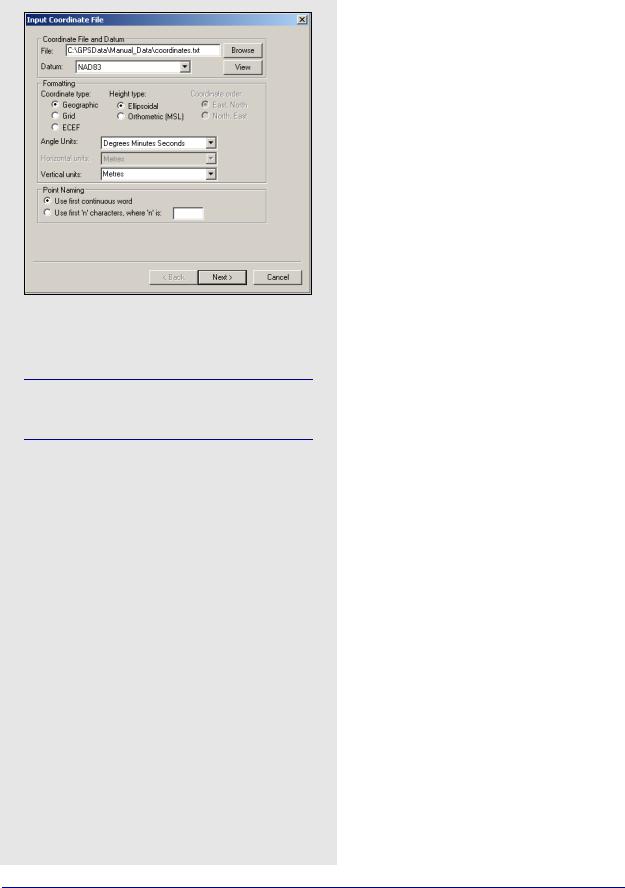
How to convert a coordinated file
1.Identify the name, datum and format of the input file.
Each line of the input file should be formatted to contain the station name followed by the coordinates.
2.Press Next. You are prompted for grid definition settings if grid coordinates were selected earlier. If not, the next step is to specify the name, datum and format desired for the output file. The Point Naming options are disabled as the program simply copies the names as read in from the input file.
3.Specify the datum transformation to be used if the input and output datums are different. You can also specify a geoid file if orthometric height is required. This is useful if you output orthometric heights because datum transformations are not applied.
2.8.8Convert Coordinate File
This tool converts large lists of coordinates. If you already have the list of coordinates in ASCII, use it because all the files can be converted easily. It can be used for converting datums, changing the height system used (ellipsoidal, orthometric) or changing to grid or ECEF coordinates. This tool can also be used to change a list of coordinates to another format, for example, from decimal degrees to DMS.
The Use first continuous word option is the default. If the station names do contain spaces, select Use first ‘n’ characters to specify a width of n characters. The software reads the first n characters as the station name, including any spaces that may be present. Geographic coordinates use positive/ negative signs to show the hemisphere. For example, latitude is positive in the Northern hemisphere and negative in the Southern, while longitude is positive for East and negative for West.
Additional options include the following:
Include column header
Conserves the header information from the input file.
View output files after conversion
Automatically opens the output file after pressing
Finish.
Input grid coordinates in southern hemisphere
Only necessary if the input data has grid coordinates from a project area that is in the southern hemisphere.
Do not apply datum transformation to height
This option is useful for outputting orthometric heights because no datum transformation are applied in this case.
134 |
GrafNav / GrafNet 8.10 User Guide Rev 4 |
GrafNav |
Chapter 2 |
|
|
|
|
2.8.9Time Conversion
This tool converts GPS into HMS (hours, minutes, seconds) and vice versa.
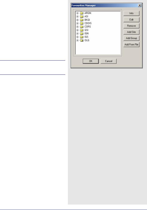
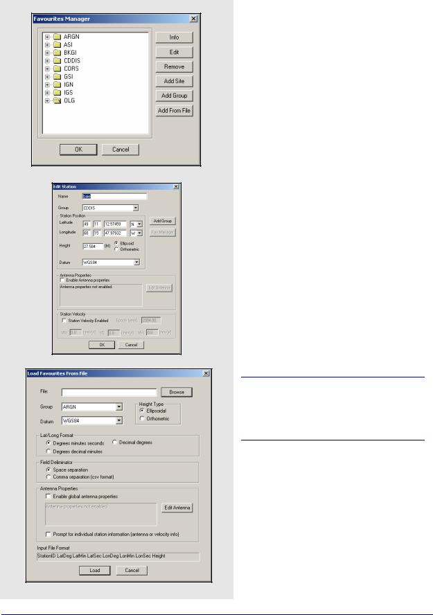
2.8.10 Favourites Manager
Use this feature to avoid retyping coordinates that are used often. Access it via the Tools menu in all Waypoint software.
Upon loading the Favourites Manager, a list of favourite groups appears. If this feature has never been used before, nine or, possibly, ten groups should appear as shown in the screen shot in the shaded box.
Previous_Fav also exists if you have Favourites from an earlier installation of the software (pre - version 6.03).
These groups contain a list of control points that continuously collect GPS data that can be downloaded free of charge via the download program (Tools | Download Service Data).
During the installation of the software, you are prompted to find the directory where any previous version of the software was installed. This automatically copies all of your files (including any previously stored Favourites) into the new version.
Follow the steps in the shaded box to manually copy your Favourites into the new version.
How to convert from a previous version to 8.10
1.Copy the file user.fvt from the 6.03 installation directory.
2.Paste it into the new 8.10 installation directory.
3.Load the Favourites Manager in version 8.10.
4.Upon loading the Favourites Manager, the Favourites from version 6.03 loads into the new version.
GrafNav / GrafNet 8.10 User Guide Rev 4 |
135 |
Chapter 2 |
GrafNav |
|
|
The following options are available in the Favourites Manager via the buttons on the righthand side:
Info
If clicked while a group is highlighted, this returns the total number of sites contained within the group. If clicked while an individual site is highlighted, the position, velocity and datum are displayed.
Edit
You can modify the information related to a station through this option, including coordinates, antenna information, and station velocities.
Remove
May be used to removed an individual site or an entire group.
Add Site
Allows for the addition of a new site into any group.
Add Group
Allows for the addition of a new group.
Add from File
Using this feature, a list of station coordinates can be directly loaded from an ASCII file, eliminating the need for manual entry. The file must contain the station names and coordinates in a commaor space-delimited format. The Input File Format box at the bottom of the window provides a useful reference for those users who are unsure as to what their input file should look like.
Southern latitudes and Western longitudes should be denoted by a negative sign. You should also take care to properly flag the inputs heights as being "Ellipsoidal" or "Orthometric".
Information regarding the stations' antennas can also be specified here. If the antenna model and/or heights are common to all the stations being added, then the Enable global antenna properties setting can be enabled to specify this information. If the information varies from station to station, then the
Prompt for individual station information option should be enabled. This latter option is also needed if you wish to specify station velocities.
136 |
GrafNav / GrafNet 8.10 User Guide Rev 4 |