

- •Table of Contents
- •Congratulations!
- •Scope
- •How to use this manual
- •Prerequisites
- •Conventions and Customer Service
- •What’s New!
- •Precise Point Positioning (PPP) processor
- •Software License
- •Warranty
- •Introduction and Installation
- •1.1 Waypoint Products Group Software Overview
- •1.2 Installation
- •1.2.1 What You Need To Start
- •1.2.2 CD Contents and Installation
- •1.2.3 Upgrading
- •1.3 Processing Modes and Solutions
- •1.4 Overview of the Products
- •1.4.1 GrafNav
- •1.4.2 GrafNet
- •1.4.3 GrafNav Lite
- •1.4.4 GrafNav / GrafNet Static
- •1.4.5 GrafMov
- •1.4.6 GrafNav Batch
- •1.4.7 Inertial Explorer
- •1.5 Utilities
- •1.5.1 Copy User Files
- •1.5.2 Download Service Data
- •1.5.3 GPS Data Logger
- •1.5.4 GPB Viewer
- •1.5.5 Mission Planner
- •1.5.6 Data Converter
- •GrafNav
- •2.1 GrafNav, GrafNav Lite and GrafNav / GrafNet Static Overview
- •2.2 Start a Project with GrafNav
- •2.3 File Menu
- •2.3.1 New Project
- •2.3.2 Open
- •2.3.3 Save Project
- •2.3.4 Save As
- •2.3.5 Print
- •2.3.6 Add Master Files
- •2.3.7 Add Remote Files
- •2.3.8 Alternate Precise / Correction Files
- •2.3.9 Show Master Files
- •2.3.10 Load
- •2.3.12 GPB Utilities
- •2.3.13 Remove Processing Files
- •2.3.15 Recent projects
- •2.3.16 Exit
- •2.4 View Menu
- •2.4.1 GPS Observations
- •2.4.2 Forward and Reverse Solutions
- •2.4.3 Processing History
- •2.4.4 Processing Summary
- •2.4.5 Return Status
- •2.4.6 Features
- •2.4.7 Objects
- •2.4.8 ASCII File (s)
- •2.4.10 Current CFG File
- •2.5 Process Menu
- •2.5.1 Process GNSS (differential)
- •2.5.2 Process PPP (single point)
- •2.5.3 Combine Solutions
- •2.5.4 Launch Batch Processor
- •2.5.5 Stop Auto Run
- •2.5.6 Load GNSS Solution
- •2.5.7 Load PPP Solution
- •2.5.8 Load Any Solution
- •2.5.9 Import Solutions and Setting
- •2.6 Settings Menu
- •2.6.1 GNSS Processing
- •2.6.2 PPP Processing
- •2.6.3 Coordinate
- •2.6.4 Individual
- •2.6.5 Datum
- •2.6.6 DEM Plotting
- •2.6.7 Photogrammetry
- •2.6.8 Manage Profiles
- •2.6.9 Compare Configuration Files
- •2.6.10 Preferences
- •2.7 Output Menu
- •2.7.1 Plot GPS Data
- •2.7.3 Plot Master / Remote Satellite Lock
- •2.7.4 Export Wizard
- •2.7.5 Write Coordinates
- •2.7.6 View Coordinates
- •2.7.7 Export Binary Values
- •2.7.8 Write Combined File
- •2.7.9 Build HTML Report
- •2.7.10 Export to Google Earth
- •2.7.11 Show Map Window
- •2.7.12 Processing Window
- •2.8 Tools Menu
- •2.8.1 Zoom In & Zoom Out
- •2.8.2 Distance & Azimuth Tool
- •2.8.3 Move Pane
- •2.8.4 Find Epoch Time
- •2.8.5 Datum Manager
- •2.8.6 Geoid
- •2.8.7 Grid/Map Projection
- •2.8.8 Convert Coordinate File
- •2.8.9 Time Conversion
- •2.8.10 Favourites Manager
- •2.8.11 Mission Planner
- •2.8.12 Download Service Data
- •2.9 Window Menu
- •2.9.1 Cascade
- •2.9.2 Tile
- •2.9.3 Next and Previous
- •2.9.4 Close Window
- •2.9.5 Close All Windows
- •2.10 Help Menu
- •2.10.1 Help Topics
- •2.10.2 www.novatel.com
- •2.10.3 About GrafNav
- •GrafNet
- •3.1 GrafNet Overview
- •3.1.1 Types of Networks
- •3.1.2 Solution Types
- •3.1.3 Computing Coordinates
- •3.2 Start a Project with GrafNet
- •3.2.1 Fix Bad Baselines
- •3.2.2 Unfixable Data
- •3.3 File
- •3.3.1 New Project
- •3.3.2 Open Project
- •3.3.3 Save Project
- •3.3.4 Save As
- •3.3.5 Print
- •3.3.6 Add / Remove Observations
- •3.3.7 Add / Remove Control Points
- •3.3.8 Add / Remove Check Points
- •3.3.9 Alternate Ephemeris / Correction Files
- •3.3.10 Remove Processing Files
- •3.3.11 Import Project Files
- •3.3.12 View
- •3.3.13 Convert
- •3.3.14 GPB Utilities
- •3.3.15 Recent projects
- •3.3.16 Exit
- •3.4 Process Menu
- •3.4.1 Processing Sessions
- •3.4.2 Rescanning Solution Files
- •3.4.3 Ignore Trivial Sessions
- •3.4.4 Unignore All Sessions
- •3.4.5 Compute Loop Ties
- •3.4.6 Network Adjustment
- •3.4.7 View Traverse Solution
- •3.4.8 View Processing Report
- •3.4.9 View All Sessions
- •3.4.10 View All Observations
- •3.4.11 View All Stations
- •3.5 Options Menu
- •3.5.1 Global Settings
- •3.5.3 Datum Options
- •3.5.4 Grid Options
- •3.5.5 Geoid Options
- •3.5.6 Preferences
- •3.6 Output Menu
- •3.6.1 Export Wizard
- •3.6.2 Write Coordinates
- •3.6.3 View Coordinates
- •3.6.4 Export DXF
- •3.6.5 Show Map Window
- •3.6.6 Show Data Window
- •3.6.7 Baselines Window
- •3.6.8 Processing Window
- •3.7 Tools Menu
- •3.8 Help Menu
- •GrafNav Batch
- •4.1 Overview of GrafNav Batch
- •4.1.1 Getting Started with GrafNav Batch
- •4.2 File Menu
- •4.2.1 New Project
- •4.2.2 Open Project
- •4.2.3 Save Project
- •4.2.4 Save As
- •4.2.5 Print
- •4.2.6 Add Baselines
- •4.2.8 Add Combined Baselines
- •4.2.9 Import CFG Files
- •4.2.10 Edit Selected Baseline Settings
- •4.2.11 Removing Selected Baselines
- •4.2.12 View ASCII Files
- •4.2.13 View Raw GPS Data
- •4.2.14 Convert GPS Data
- •4.2.15 GPB Utilities
- •4.2.16 Remove Process Files
- •4.2.17 Recent Projects
- •4.2.18 Exit
- •4.3 Process Menu
- •4.3.1 Process All Baselines
- •4.3.2 Process Selected
- •4.3.3 GrafNav on Selected Baselines
- •4.3.4 View Selected Processing Summary
- •4.3.5 Load All Solutions
- •4.3.6 Load Selected Solutions
- •4.4 Settings Menu
- •4.4.1 Global
- •4.4.2 Selected
- •4.4.3 Copy Processing Options
- •4.4.4 Load into Selected From
- •4.4.5 Manage
- •4.4.6 Preferences
- •4.5 Output Menu
- •4.5.1 Plot Selected GPS Data
- •4.5.2 View Selected Map
- •4.5.3 Export All
- •4.5.4 Export Selected
- •4.6 Tools Menu
- •4.7 Windows
- •4.8 Help Menu
- •GrafMov
- •5.1 Overview of GrafMov
- •5.2 Getting Started with GrafMov
- •5.3 File Menu
- •5.3.1 Add Master File
- •5.4 View Menu
- •5.5 Process Menu
- •5.6 Setting Menu
- •5.6.1 Moving Baseline Options
- •5.7 Output Menu
- •5.7.1 Plot GPS Data
- •5.8 Tools Menu
- •5.9 Interactive Windows
- •5.10 Help Menu
- •AutoNav
- •6.1 Overview of AutoNav
- •6.2 Getting Started with AutoNav
- •6.3 Base Station Files
- •6.4 Remote Files
- •6.5 Interactive Windows
- •File Formats
- •7.1 Overview of the File Formats
- •7.2 CFG File
- •7.3 GPS Data Files
- •7.3.1 GPB File
- •7.3.2 STA File
- •7.3.3 Old Station File Format
- •7.3.4 EPP File
- •7.4 Output Files
- •7.4.1 FML & RML Files
- •7.4.2 FSS & RSS Files
- •7.4.3 FWD & REV Files
- •7.4.4 FBV & RBV Files
- •Utilities
- •8.1 Utilities Overview
- •8.2 GPB Viewer Overview
- •8.2.1 File
- •8.2.2 Move
- •8.2.3 Edit
- •8.3 Concatenate, Splice and Resample Overview
- •8.3.1 Concatenate, Splice and Resample GPB Files
- •8.4 GPS Data Converter Overview
- •8.4.1 Convert Raw GPS data to GPB
- •8.4.2 Supported Receivers
- •8.5 GPS Data Logger Overview
- •8.5.1 Getting Started with WLOG
- •8.5.2 File
- •8.5.3 Display
- •8.5.4 Plot
- •8.5.5 Zoom Menu
- •8.5.6 Events Menu
- •8.6 WinCE Data Logger Overview
- •8.6.1 Installing CELOG
- •8.6.2 Getting Started with CELOG
- •8.6.3 Variable Display File
- •FAQ and Tips
- •9.1 Overview of FAQ and Tips
- •9.2 General FAQ and Tips
- •9.2.1 How can I store Master Station Coordinates?
- •9.2.2 How can I obtain Master Station Coordinates?
- •9.2.3 How can I customize output formats?
- •9.2.4 How can I download base station data?
- •9.3 Kinematic Processing FAQ and Tips
- •9.3.2 Should I combine forward and reverse solutions?
- •9.3.3 How can I use static / kinematic flags?
- •9.3.4 How do I eliminate problem satellites?
- •9.3.5 How do I set the measurement standard deviations?
- •9.3.6 How do I control bad data?
- •9.3.7 How do I avoid missing epochs?
- •9.3.8 Should I avoid using RINEX for kinematic data?
- •9.3.9 How do I process kinematic data logged during an ionospheric storm?
- •9.3.10 How do I process long kinematic baselines?
- •9.4 Integer Ambiguity Determination Tips
- •9.4.1 How can I detect and fix incorrect integer fixes?
- •9.4.2 How can I help KAR/ARTK find a solution?
- •9.4.3 How can I use KAR and ARTK to improve poor combined separations?
- •9.5 Static Processing FAQ and Tips
- •9.5.1 Can I use GrafNet for static batch processing?
- •9.5.2 Can I use kinematic processing on static baselines?
- •9.5.3 Using KAR or ARTK in GrafNet
- •9.5.4 How can I optimize the fixed static solution?
- •9.5.5 How can I refine L1/L2 integer solutions?
- •9.5.6 Can I use a larger interval for static processing?
- •9.5.7 How do I process static data logged during ionospheric storms?
- •9.5.8 How do I process long static baselines?
- •9.6.1 How should I choose a processing mode?
- •9.6.2 How important are base station coordinates?
- •9.6.3 How can I use the MB Plots?
- •9.6.4 How do I select a data interval?
- •9.6.6 How should I decide which base stations to use?
- •9.6.7 How do I deal with problematic baselines?
- •9.6.9 How can I use the fixed static solution?
- •9.6.10 What is the best way to process data with large base to rover separations?
- •9.6.11 How can I speed up processing?
- •9.7 PPP (Precise Point Positioning)
- •9.7.1 What is Precise Point Positioning?
- •9.7.2 How does PPP differ from differential processing?
- •9.7.3 How accurate is PPP?
- •9.7.4 What is PPP used for?
- •9.7.5 Who should use PPP?
- •9.7.6 Are there any limitations to PPP?
- •9.8 Common Inquiries
- •9.8.1 How can I determine the quality of a final solution?
- •9.8.2 How do I copy user files?
- •9.8.3 How do I update manufacturer files?
- •9.8.4 How do I produce local coordinates?
- •9.8.5 How do I define a local cartesian coordinate system?
- •9.8.6 How do I define a local coordinate grid?
- •9.8.7 How do I process an aerial survey with camera event marks?
- •9.9 Digital Elevation Models (DEM) FAQ and Tips
- •9.9.1 Why would I use a DEM?
- •9.9.2 What are the DEM sources?
- •9.9.3 What DEM formats are supported by GrafNav?
- •9.9.4 How do I handle large DEMs?
- •9.10 Datum FAQ and Tips
- •9.10.1 What are the available datums - related features?
- •9.10.2 How are datums handled within the software?
- •9.10.3 How do I make additional datums available?
- •9.10.4 How do I enter a 7-parameter transformation?
- •9.10.6 How do I use NADCON conversion files?
- •9.10.7 How do I prevent corruption from conversion errors?
- •9.11 Projections FAQ and Tips
- •9.11.1 What features are available with map projections?
- •9.12 Geoid FAQ and Tips
- •9.12.1 What are the available geoid - related features?
- •9.12.2 How can I create a WPG file?
- •A: Output Variables
- •B: Antenna Measurements Diagram
- •C: Summary of Commands
- •Index
Chapter 8 |
Utilities |
|
|
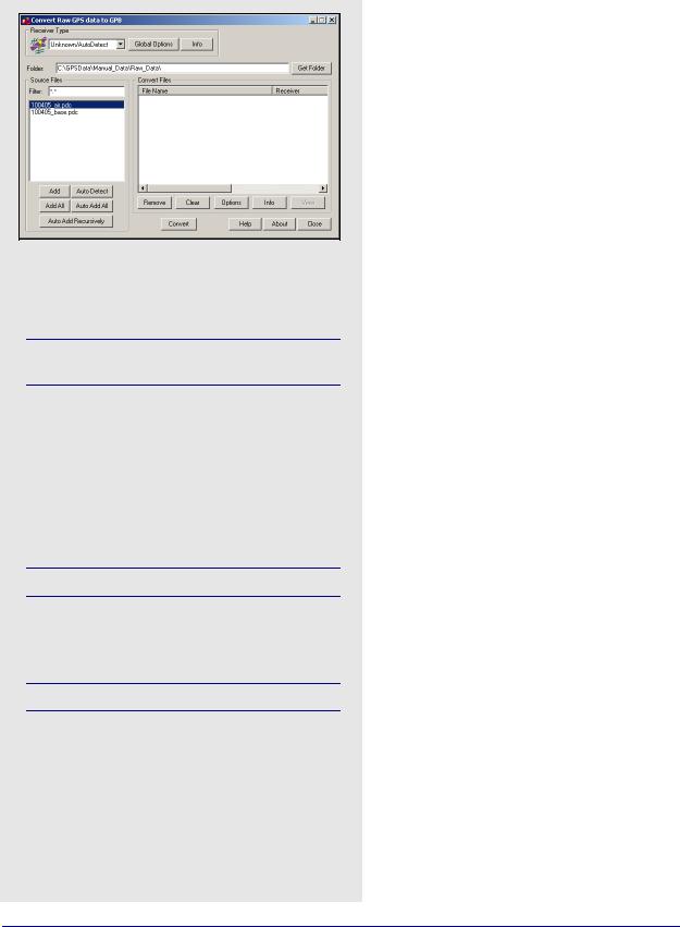
8.4GPS Data Converter Overview
Source file options
Add
Adds the selected file in the Source Files window to the Convert Files list.
If a receiver type has not been specified, the utility will attempt to perform auto-detection.
Add All
If a receiver is selected, it adds all files in the Source Files list to the Convert Files list as data files. Otherwise, it performs auto-detection on every file in the Source Files list.
Auto Detect
Auto-detects the selected file in the Source Files window for conversion.
Not all receivers are automatically detected.
Auto Add All
Auto-detects all the files showing in the Source Files list for conversion.
Not all receiver types are automatically detected
Auto Add Recursively
Auto-detects all files in the immediate folder and its subfolders. 128 files can be added.
If you logged data with any logging utility other than Waypoint’s, this utility converts data into GPB format. If you logged data with Waypoint’s logging software and saved it to a binary LOG file, also convert this data. This tool decodes raw GPS data from numerous receivers and is available in all of Waypoint’s programs. The supported receivers are listed in Section 8.4.2, on Page 229 .
8.4.1 Convert Raw GPS data to GPB
Receiver Type
Choose the receiver used to collect the data. Otherwise, leave the selection at Unknown/ AutoDetect.
Global Options
These options depend on the type of receiver and are applied the raw data files in the Convert Files window that were logged using that receiver type and are retained as future values.
Info
Provides information on the version and status of the DLL file used for the conversion, including whether it is loaded and allows for auto-detection.
Folder
Specifies the folder to look for data in. Type the directory in manually, or browse for it with the Get Folder button.
Source Files
Lists the files in the folder with filtered extensions matching those specified in the Filter field. The options available here are listed in the shaded box.
Convert Files
This lists all the files waiting to be converted and has icons corresponding to their associated receiver type. Once the Convert button is pressed, these icons indicate whether or not conversion was successful. Options available here including the following:
Remove
Removes the selected file from the Convert Files window.
Clear
Remove all files from the Convert Files window.
Options
Displays the options associated with the receiver type of the selected file. Any change are only applied to the selected file and will not be retained.
228 |
GrafNav / GrafNet 8.10 User Guide Rev 4 |
Utilities |
Chapter 8 |
|
|
|
|
Info
Displays file path, receiver type, and conversion status of the selected file.
View
Available after conversion to open the selected file in GPBView.
8.4.2Supported Receivers
This section discusses the receivers that are currently supported by the Raw GPS Data to GPB converter. This information includes the conversion options, as well as the supported formats and records for each receiver.
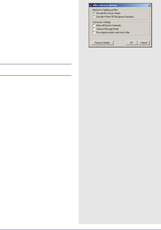
Allen Osborne Associates (AOA)
The converter for this receiver is only available in the AOA version of the software.
Convert Turbo Binary (TB) files to GPB using this utility. Normally, one TB file contains data from many sessions (or even days) so the decoder must split the files up to be compatible with the software and look at the Begin Session and End Session marks in the TB file. These are created when you mark the beginning and end of a session. The session name in the receiver are used to name the file, with the Julian day number appended to it.
Method for Splitting Up File
The two choices are listed in the shaded box.
Conversion Settings
The three options are listed in the shaded box.
Conexant Jupiter
This is a code-only receiver. Ephemeris measurements are in record #1102, use record #1000 for position measurements. The general options are in the shaded box.
Time Skewing
The following options are available:
Leave measurements raw
Use time data as it is found in the raw data.
Skew to whole second using linear interpolation
Shift to integer second.
Skew to whole second using polynomial
Shift to integer second.
Ephemeris Options
The options are in the shaded box.
AOA methods for splitting up files
Decode my Session Name
Decodes the TB file based on session marks inputted into the receiver.
Decode Whole TB File
Decodes the entire TB file with the assumption that all the data collected was from one session
AOA conversion settings
Make All Epochs Kinematic
Sets file to kinematic mode.
Verbose Message Mode
Alerts you of additional warnings and errors that have occurred.
Re-compute position and clock offset
Enable this option if the clock shift data is corrupt, or positions records are not present.
Conexant Jupiter general options
Make all epochs Kinematic
Entire file will be set to kinematic mode.
Re-compute position and clock offset
Enable this option if the clock shift data is corrupt, or if positions records are not present.
Keep epochs where recalculation failed
If time recalculation failed, the measurements may cause problem. Enable to ignore records in this case.
Do not check data record checksum
Enable to ignore record integrity checks.
Conexant Jupiter ephemeris options
Use alternate ephemeris file
Use EPP file from another source.
Ignore Jupiter ephemeris records
If many corrupted records exist, the ephemeris record, #1102 might be unusable.
GrafNav / GrafNet 8.10 User Guide Rev 4 |
229 |
Chapter 8 |
Utilities |
|
|
Table 16: Records Supported for CSI SLX and DGPSMax
Record |
Type |
Comment |
|
|
|
96 |
Measurements |
Required. |
|
|
|
95 |
Ephemeris |
Required. |
|
|
|
1 |
Position |
Recommended for GrafNet users. |
|
|
|
Table 17: Records Supported for Javad & Topcon
Record |
Type |
Comment |
|
|
|
|
|
RC, rc |
C/A Code |
RC suggested. |
|
Measurement Block |
|||
|
|
||
|
|
|
|
R2, r2, |
L2 P-Code |
2R suggested. |
|
2R, 2r |
Measurement Block |
||
|
|||
|
|
|
|
PC, pc, |
L1 Phase |
CP suggested. |
|
CP, cp |
Measurement Block |
||
|
|||
|
|
|
|
P2, p2, |
L2 Phase |
2P suggested. |
|
2P. 2p |
Measurement Block |
||
|
|||
|
|
|
|
DC |
L1 Doppler |
Strongly recommended. |
|
Measurements |
|||
|
|
||
|
|
|
|
GE |
GPS Ephemeris |
Required. |
|
|
|
|
|
NE |
GLONASS |
Required. |
|
Ephemeris |
|||
|
|
||
|
|
|
|
TO |
Clock Offset |
|
|
|
|
|
|
TC |
Locktime |
|
|
|
|
|
|
PO |
Position |
Recommended for GrafNet |
|
Users. |
|||
|
|
||
|
|
|
|
SI |
PRN List |
|
|
|
|
|
|
RD |
Receiver Date |
|
|
|
|
|
|
OEM |
Measurements |
Compressed record; more |
|
robust. |
|||
|
|
||
|
|
|
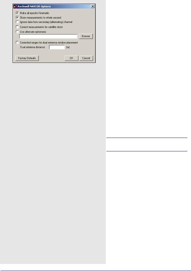
Conexant NAVCOR
Make all epochs Kinematic
Entire file will be set to kinematic mode.
Skew measurements to whole second
Shift to whole second.
Ignore data from secondary (alternating) channel
Fifth channel on this receiver alternates between remaining satellites. Enable this to ignore.
Correct measurements for satellite clock
Should be disabled.
Use alternate ephemeris
Enable if ephemerides data missing.
Corrected ranges for dual antenna window placement
For CSSI users only.
CSI SLX and DGPS-MAX
Table 16 describes the supported records.
Make all epochs kinematic
Enabling this option sets the entire output GPB file to kinematic mode. Otherwise, it will be set entirely to static mode.
Javad & Topcon
This converter supports GLONASS-enabled receivers.
Table 17 describes the supported records.
The following describes the options available for this converter:
Decode GPS Only
This option forces the decoder to ignore all GLONASS data.
Make all epochs kinematic
The entire file will be set to kinematic mode.
Use code and carrier from P1 instead of C/A
Measurements from P1 can be used instead, but this is not recommended.
Use JPS locktimes for cycle slip detection
Locktimes from the Javad receiver are used instead of those computed by the decoder. Enabled this if Javad locktimes are problematic.
230 |
GrafNav / GrafNet 8.10 User Guide Rev 4 |
Utilities |
Chapter 8 |
|
|
|
|
Ignore entire epoch if check failed on element
Ignores GPS data for the entire epoch when a checksum error is reported for incoming records. Otherwise, only the affected data is ignored.
Use SAVE marker to store sites to.sta file
Markers are saved to an STA file.
Reject entire record if L2 phase is missing
Enable if logging rate is high.
Verbose messaging mode
Alerts of warnings and errors that have occurred.
Write new GPB format
Converts data into the new GPB format.
Re-compute position and clock offset
GrafNav requires valid clock shift data, while GrafNet requires position records. Enable this option if the clock shift data is corrupt, or if positions records are not present.
Re-compute Doppler
Forces the decoder to re-compute all Doppler values using the C/A code. Enable if the Doppler measurements are missing or unstable.
If GRIL and OEM Format are Mixed
Allows you to choose which format should be used in the event that both are mixed.
Leica SR and MX
Leica raw GPS measurement data comes in two types of formats. The MX series data files are produced by the MX 4200 and 9200 receivers while the SR series data formats are produced by the SR-299, 399, 9400, 9500 sensors. The SR files usually start with DS. The decoder detects if the files are from the SR or MX series.
The Table 18 describes the files supported for the SR series and Table 19 describes the records and files supported for the MX series.
Make all epochs kinematic
Sets file to kinematic. Applies to MX format.
Reject measurements that Leica declares bad
Leica’s rejection flags are very sensitive, and better results can often be obtained by ignoring them. If bad measurements are a problem, this option should be enabled. Applies to SR series.
Breakup chains into separate files
For SR files that contain more that one static session (chain) per file, this option splits the chains up into separate GPB files.You will be prompted for IDEX file. See the note in the shaded box.
Table 18: Files Supported for Leica SR
File |
Type |
Comment |
|
|
|
|
|
DS*.obs |
Measurements |
Required. |
|
|
|
|
|
DS*.eph |
Ephemeris |
Required. |
|
|
|
|
|
DS*.cmp |
Position |
Recommended for GrafNet users. |
|
|
|
|
|
DS*.ttp |
Station |
See Notes. |
|
|
|
|
|
DS*.evt |
Event Mark |
|
|
|
|
|
|
DS*.chn |
Static Chains |
|
|
|
|
|
|
*.TDU |
Event Mark |
Produced by TDU units running with SR |
|
series; read in directly by software. |
|||
|
|
||
|
|
|
Table 19: Records and Files Supported for Leica MX
|
Record/File |
Type |
Comment |
|
|
|
|
|
2 |
Measurements |
Required for 6 channels. |
|
|
|
|
|
3 |
Measurements |
Required for 12 channels. |
|
|
|
|
|
8 |
Position |
Recommended for GrafNet |
|
|
|
users. |
|
|
|
|
|
200 |
|
|
|
201 |
Ephemeris |
One of these |
|
202 |
records is required. |
|
|
|
||
|
203 |
|
|
|
|
|
|
|
*.EV0 |
Event Mark |
Produced by ASCOT system with |
|
MX series; read in directly by |
||
|
|
|
software. |
|
|
|
|
|
|
|
|
One limitation of the SR decoder is the inability to copy alphanumeric station names properly since only the numeric index is retained. This occurs in Version 3.0 and on. The value retained is in an index of a list of station names that are contained in the Leica file system. To circumvent this, load an IDEX file into GrafNav for kinematic processing, or else into the decoder directly for static chains. See Leica IDEX file on Page 46 for help creating an IDEX file.
GrafNav / GrafNet 8.10 User Guide Rev 4 |
231 |

Chapter 8 |
Utilities |
|
|
Table 20: Records Supported for Leica 500
Record |
Type |
Comment |
|
|
|
|
|
19 |
Measurements |
One of these records is |
|
(compressed) |
|||
|
required; |
||
|
|
record #20 needed if |
|
|
Measurements |
||
20 |
Doppler data is of interest. |
||
(expanded) |
|||
|
|
||
|
|
|
|
15 |
Ephemeris |
Required. |
|
|
|
|
|
10 |
Position |
Recommended for GrafNet |
|
users. |
|||
|
|
||
|
|
|
|
13 |
Station/Event |
Written to STA file. |
|
Mark |
|||
|
|
||
|
|
|
|
9 |
Antenna |
Written to STA file. |
|
Height |
|||
|
|
||
|
|
|
Table 21: Records Supported for Leica 1200
Record |
Type |
Comment |
|
|
|
|
|
120 |
Measurements |
Required. |
|
|
|
|
|
115 |
Ephemeris |
Required. |
|
|
|
|
|
110 |
Position |
Recommended for |
|
GrafNet users. |
|||
|
|
||
|
|
|
|
109 |
Antenna Height |
Written to STA file. |
|
|
|
|
|
113 |
Event Mark |
Written to STA file. |
|
|
|
|
Leica System 500
This decoder handles data from the System 500 or SR530 receivers.
Table 20 describes the supported records.
Re-compute position and receiver clock
Enable this option if the clock shift data is corrupt, or if positions records are not present.
Combine multiple (.o00,.o01…) files into single GPB file
Leica SR530 receivers write all data into separate files from one session with different extensions. Enabling this option will combine files from one session into one GPB file
Use P1 carrier instead of CA carrier for L1 phase
Measurements from P1 can be used instead, but this is not recommended. Only available if Record #20 was logged.
Verbose message information output
Alerts you of additional warnings and errors that have occurred.
Scale L1 Doppler to L1 cycles
Recalculates Doppler to correct early Leica firmware bug.
Insert kinematic markers after gaps and stations
Ensures that static sessions are properly created.
Use new station format for output
Utilizes a more-detailed format.
Use new GPB format
Converts data into the new GPB format.
Leica System 1200
Table 21 describes the supported records.
Re-compute position and receiver clock offset
Enable this option if the clock shift data is corrupt, or if positions records are not present.
Make all epochs kinematic
Entire file will be set to kinematic mode.
Use new GPB format
Converts data into the new GPB format.
Combine multiple observation files
Leica receivers write data into separate files from one session with different extensions. This option combines files from one session into one GPB file
Verbose message information output
Alerts you of additional warnings and errors that have occurred.
232 |
GrafNav / GrafNet 8.10 User Guide Rev 4 |
Utilities |
Chapter 8 |
|
|
|
|
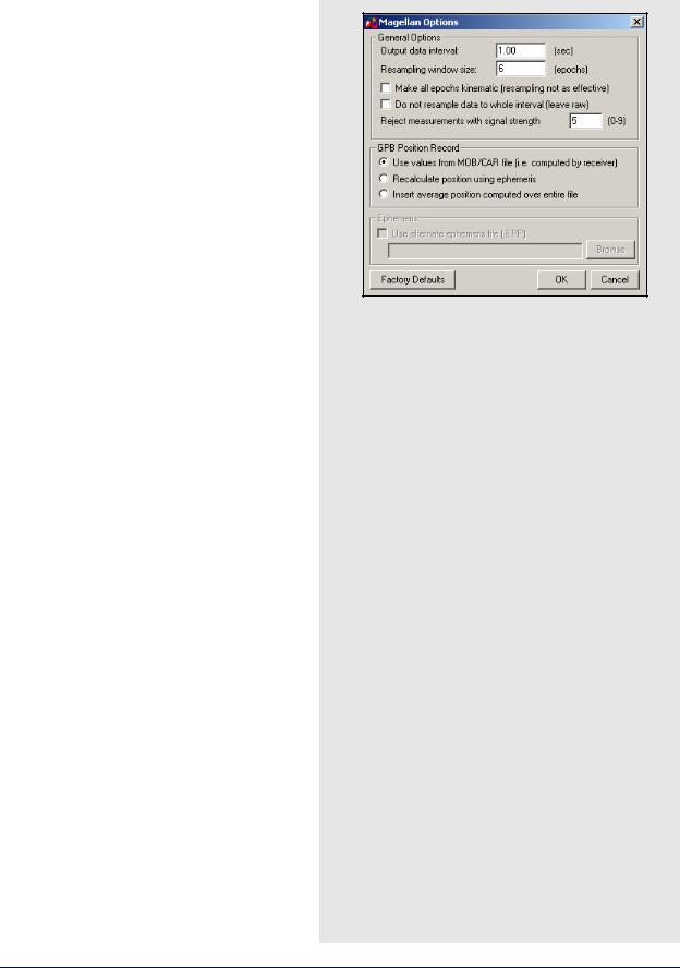
Magellan ProMark
General Options
Output data interval
Resample data to specified interval.
Resampling window size
Number of epochs used for resampling operation. Not recommended for use with kinematic data.
Make all epochs kinematic
Sets file to kinematic mode.
Do not resample data to whole interval
If data is kinematic, use the Concatenate, Splice and Resample utility to resample the data using the base station interval. See Section 8.3, on Page 226 for help.
Reject measurements with signal strength
Reject very poor measurements. Users should consult receiver documentation.
GPB Position Record
The following options are available:
Use values from MOB/CAR file
Utilize position computed by receiver.
Recalculate position using ephemeris
Recompute position by decoder.
Insert average position computed over entire file
Use average of values compiled by receiver.
Ephemeris
If ephemerides are missing or incomplete in the raw data, enable the Use alternate ephemeris file (.EPP) option to specify an outside source.
NavCom
Table 22 describes the supported records.
Make all epochs kinematic
Entire file will be set to kinematic mode.
Re-compute position and clock offset
Enable this option if the clock shift data is corrupt, or if positions records are not present.
Report L2 cycle slips
Print message if L2 cycle slip encountered.
Verbose messaging mode
Allows you to see additional warning messages.
Use new GPB format
Converts data into the new GPB format.
Table 22: Records Supported for NavCom
Record |
Type |
Comment |
|
|
|
|
|
0xB0 |
Measurements |
Required. |
|
|
|
|
|
0x81 |
Ephemeris |
Required. |
|
|
|
|
|
0xB1 |
Position |
Recommended for |
|
GrafNet users. |
|||
|
|
||
|
|
|
|
0xB4 |
Event Marker |
Written to STA file. |
|
|
|
|
GrafNav / GrafNet 8.10 User Guide Rev 4 |
233 |

Chapter 8 |
Utilities |
|
|
Table 23: Records Supported for NovAtel CMC
Record |
Type |
Comment |
|
|
|
|
|
ID #23 |
Measurements |
|
|
|
|
|
|
ID #13 |
Measurements |
|
|
(old style) |
|
||
|
One of these records is |
||
|
|
||
|
Measurements |
||
ID #14 |
required, but |
||
(old style) |
ID #23 is strongly |
||
|
|||
|
|
recommended |
|
ID #15 |
Measurements |
over the others. |
|
(old style) |
|
||
|
|
||
|
|
|
|
ID #16 |
Measurements |
|
|
(old style) |
|
||
|
|
||
|
|
|
|
ID #20 |
Position |
Recommended for GrafNet |
|
users; |
|||
|
|
should be requested last. |
|
|
|
|
|
ID #22 |
Ephemeris |
Required. |
|
|
|
|
NovAtel CMC
This decoder handles data from the NovAtel CMC AllStar and SuperStar receivers. Table 23 describes the supported records.
Make all epochs Kinematic
Sets file to kinematic mode.
Verbose messaging mode
Displays additional warning messages.
Reject satellites with low CNO
Satellites with low CNO will not be decoded.
Write new GPB format
Converts data into the new GPB format.
234 |
GrafNav / GrafNet 8.10 User Guide Rev 4 |
Utilities |
Chapter 8 |
|
|
|
|
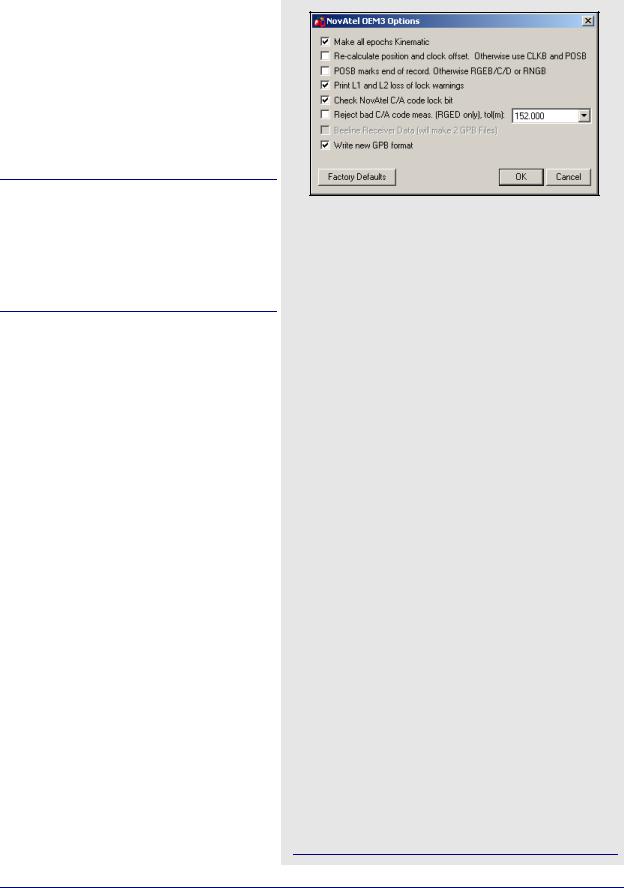
NovAtel OEM2, OEM3 and SoftSurv
This decoder handles data from the NovAtel OEM2/Softsurv and the NovAtel OEM3 receivers. Table 24 describes the supported records and files.
Make all epochs Kinematic
Sets the entire file to kinematic mode.
Re-calculate position and clock offset
If there is no POSB record, this option to recalculates the position and time.
The REPB record must be present, any epochs collected before the first REPB are not re-calculated. Section 8.2.3.2, on Page 224 for help correcting this.
To ensure enough ephemerides, the REPB record should be requested ONCE on start-up and ONCHANGED afterwards.
POSB marks the end of record
If the POSB record is requested after the measurement record, this option ensures that their time records match. Otherwise, request the measurement record last. This is only used when RTK or DGPS positions are to be preserved.
Print L1 and L2 loss of lock warnings
Alerts you of the losses of lock on carrier phase.
Check NovAtel C/A code lock bit
If the receiver flags a C/A code measurement as being bad, the entire measurement record is ignored.
Reject bad C/A code meas.
Applies only to the RGED record, where a code is used to indicate the range of values that the standard deviation of the pseudorange measurement falls under. This option uses this code to reject bad C/A code measurements.
Beeline Receiver Data
Splits Beeline data into two files for primary and secondary antennas.
Write new GPB format
Converts data into the new GPB format.
Table 24: Records and Files Supported for NovAtel OEM2, OEM3 and SoftSurv
|
Record/File |
Type |
Comment |
|
|
|
|
|
RGEB (ID #32) |
Measurements |
|
|
(expanded) |
|
|
|
|
|
|
|
|
|
One of these records is |
|
|
Measurements |
|
|
RGEC (ID #33) |
required, but RGED is |
|
|
(compressed) |
||
|
|
recommended. |
|
|
|
|
|
|
RGED (ID #65) |
Measurements |
|
|
(compressed) |
|
|
|
|
|
|
|
|
|
|
|
REPB (ID #14) |
Ephemeris |
Required. |
|
|
|
|
|
POSB (ID# 01) |
Position |
Recommended for |
|
GrafNet users. |
||
|
|
|
|
|
|
|
|
|
MKTB (ID# 04) |
Event Mark (time |
Written to STA file. |
|
only) |
||
|
|
|
|
|
|
|
|
|
MKPB (ID # |
Event Mark (time |
Written to STA file. |
|
05) |
and position) |
|
|
|
||
|
|
|
|
|
CLKB (ID# 02) |
Clock Information |
See Notes. |
|
|
|
|
|
*.orb |
Ephemeris |
Required for SoftSurv. |
|
|
|
|
|
|
|
|
1. If using receivers with standard correlators, you should either request the CLKB record, or else recalculate the position and clock information. See the description of the decoder options on this page. The clock correction (offset) is needed for processing. This record is also suggested for users logging data right from power-up. Request the CLKB record before the measurement record.
2.Ensure that the baud rate is set high enough to properly handle 12 channels worth of measurement records, as well any additional records.
3.The GPS/GLONASS MiLLennium receiver has 24 channels.
4.Log MKTB or MKPB, but not both.
GrafNav / GrafNet 8.10 User Guide Rev 4 |
235 |

Chapter 8 |
Utilities |
|
|
Table 25: Records Supported for Novatel OEM4
Record |
Type |
Comment |
|
|
|
|
|
RANGEB (ID #43) |
Measurements |
|
|
(expanded) |
One of these |
||
|
|||
|
|
records is required |
|
RANGECMPB (ID #140) |
Measurements |
||
|
|||
(compressed) |
|
||
|
|
||
|
|
|
|
UCRANGE (ID #64000) |
Measurements |
This is a non- |
|
(Waypoint Ultra |
standard log. See |
||
|
Compressed) |
Note 1 |
|
|
|
|
|
RAWEPHEMB (ID #41) |
Ephemeris |
Required |
|
|
|
|
|
GLOEPHEMERISB (ID |
GLONASS |
Required for |
|
#723) |
Ephemeris |
OEMV-3 |
|
|
|
|
|
ALMANACB (ID# 73) |
Decoded |
|
|
Almanac |
|
||
|
|
||
|
|
Written to EPP file; |
|
RAWALMB (ID #74) |
Raw Almanac |
||
see Note 2 |
|||
|
|
||
GLOALMANACB (ID #718) |
GLONASS |
|
|
Almanac |
|
||
|
|
||
|
|
|
|
BESTPOSB (ID #42) |
Position |
Recommended for |
|
GrafNet users |
|||
|
|
||
|
|
|
|
MARKTIMEB (ID #231) |
Event Mark |
Written to STA file |
|
Time |
|||
|
|
||
|
|
|
|
PRPCLKMODELB (ID #71) |
Propagated |
This is a non- |
|
Clock Model |
standard log |
||
|
|||
|
|
|
|
TIMEB (ID #101) |
Receiver Time |
|
|
Information |
|
||
|
|
||
|
|
|
|
IONUTCB (ID #8) |
Ionospheric |
|
|
Parameters |
|
||
|
|
||
|
|
|
|
|
GLONASS |
Recommended for |
|
GLOCLOCKB (ID #719) |
Clock |
||
OEMV-3 |
|||
|
Information |
||
|
|
||
|
|
|
|
RAWIMUSB (ID #325) |
IMU |
SPAN Technology |
|
Measurements |
users only |
||
|
|||
|
|
|
|
MARK2TIMEB (ID #616) |
Event Mark |
Written to -2.STA |
|
Time |
file |
||
|
|||
|
|
|
|
BESTLEVERARMB |
IMU to GPS |
SPAN Technology |
|
(ID #674) |
Lever Arm |
users only |
|
|
|
|
|
BESTGPSPOSB (ID #423) |
Best GPS |
SPAN Technology |
|
Position |
users only |
||
|
|||
|
|
|
|
SETIMUTYPE (ID #569) |
IMU Type |
SPAN Technology |
|
users only |
|||
|
|
||
|
|
|
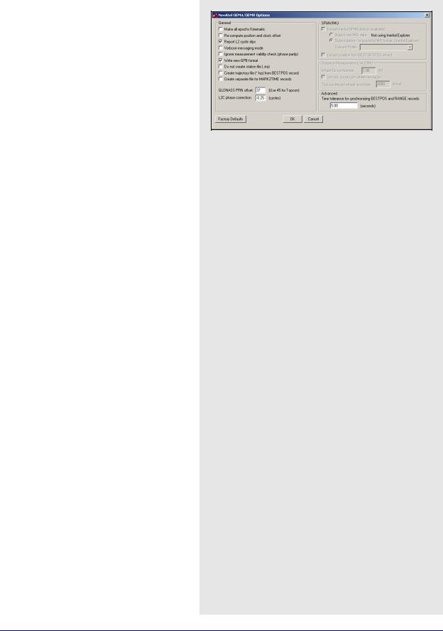
NovAtel OEM4 / OEMV
Table 25 describes supported files.
1. Contact Waypoint to obtain the OEM4 onboard program. See on Page 15 for information.
2.Almanac data can be used in Mission Planner. See Section 2.8.11, on Page 137 for help.
Make all epochs Kinematic
Entire file will be set to kinematic mode.
Re-compute position and clock offset
GrafNav requires valid clock shift data, while GrafNet requires position records. Enable this option if the clock shift data is corrupt, or if positions records are not present.
Report L2 cycle slips
Alerts you of L2 phase lock problems.
Verbose messaging mode
Displays additional warning messages.
Ignore measurement validity check
Utilizes more measurements by ignoring NovAtel data validity checks.
Write new GPB format
Converts data into the new GPB format.
Do not create station file (.sta)
You can enable this option if you have not logged any events to avoid the creation of a blank STA file.
236 |
GrafNav / GrafNet 8.10 User Guide Rev 4 |
Utilities |
Chapter 8 |
|
|
|
|
Create trajectory file (*.fsp) from BESTPOS record
Enable this option if you wish to have your realtime solutions, as recorded by the BESTPOSB record, written into an FSP file which can be read in by the software.
L2C phase correction
This correction value is inserted into the GPB header and can be used by the post-processing engine. OEMV firmware versions 3.0 and 3.1 use a correction of 0.50, while firmware versions 3.2 and later will use either -0.25 or 0.00. Generally, this value should occur on the ¼ cycle. See
Ionosphere/L2 Options on Page 79.
Inertial Decoding Options
Extract inertial SPAN data
This option is only for users of NovAtel’s SPAN Technology, and is only available in Inertial Explorer. Refer to Inertial Explorer Version 7.70 Manual for details.
Time tolerance for synchronizing BESTPOS and RANGE records
Assigns position to GPB record if time difference between measurement and position records is less than tolerance.
GrafNav / GrafNet 8.10 User Guide Rev 4 |
237 |
Chapter 8 |
Utilities |
|
|
Table 26: Files Supported for RINEX
|
File |
Type |
Comment |
|
|
|
|
|
*.yyo, |
Measurements |
|
|
*.obs, |
|
|
|
*.rxo |
|
One of these |
|
|
|
files is required. |
|
*.yyd |
Measurements |
|
|
|
||
|
(compressed) |
|
|
|
|
|
|
|
|
|
|
|
*.yyn, |
GPS Ephemeris |
|
|
*.nav, |
|
|
|
*.rxn |
|
Required. |
|
|
|
|
|
.yyg |
GLONASS |
|
|
Ephemeris |
|
|
|
|
|
|
|
|
|
|
|
|
|
|
The yy in the file extensions found in the table above designate the last two digits of the year that the observations were collected in.
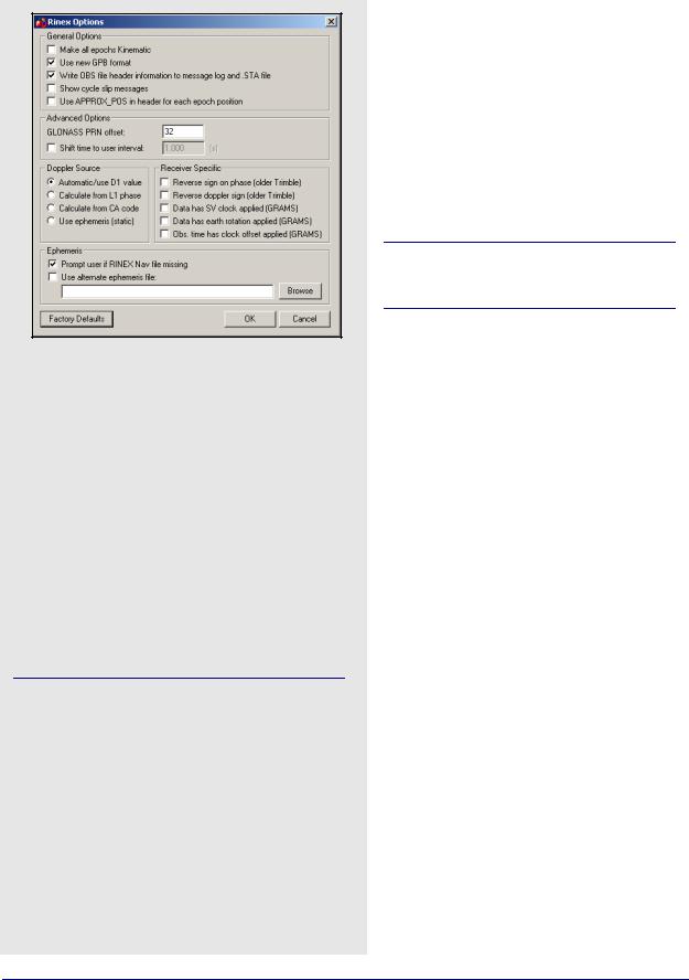
RINEX
Receiver Independent Exchange (RINEX) data consists of two ASCII files. The first is referred to as the observation file and contains the measurement data. The second file is the navigation file and contains ephemeris data.
RINEX is a very flexible format. It is interpreted differently by receiver manufacturers, software developers and government agencies. For this reason, RINEX data occasionally causes problems, and the use of options is necessary to convert the data properly to GPB.
This decoder also supports Hatanaka (compressed) RINEX data. It also supports GLONASS measurements and ephemerides.
Table 26 describes the supported files.
The following describes the options available for this converter:
General Options
Make all epochs Kinematic
Entire file will be set to kinematic mode.
Use new GPB format
Converts data into the new GPB format.
Write OBS file header information to message log and .STA file
Saves header information from observation file to message log and station file. Can be useful for determining receiver and antenna type.
Show cycle slip messages
Prints L1 and L2 cycle slip messages.
Use APPROX_POS in header for each epoch position
Uses approximate position from header in observation file for each epoch's position.
Advanced Options
The following options are available:
GLONASS PRN offset
Shifts PRN number for GLONASS satellites. Offset must be greater than 32 to avoid conflict with GPS constellation.
Shift time to user interval
The decoder will attempt to determine the data interval by reading the header or scanning the observation file. If this fails, enable this option to force an interval.
238 |
GrafNav / GrafNet 8.10 User Guide Rev 4 |
Utilities |
Chapter 8 |
|
|
|
|
Doppler Source
This options allows you to choose a method of obtaining Doppler measurements. The following choices are available:
Automatic/use D1 value
Uses D1 value, if present, from RINEX file for Doppler. Otherwise, it uses Calculate from CA code for data intervals of 10 seconds or less, and
Use ephemeris (static) for anything else.
Calculate from L1 phase
Should be selected if the Doppler signal is missing or unstable.
Calculate from CA code
If the Doppler signal is missing or unstable, using the CA code will create fewer problems than using L1 phase, but velocity accuracies may be worse.
Use ephemeris (static)
Assumes static data and computes Doppler from satellite velocities.
Receiver Specific
The following settings are available:
Reverse sign on phase (Trimble)
Some older versions of the Trimble software created RINEX files with incorrect signs on the phase measurements.
Reverse Doppler sign (Trimble)
Some older versions of the Trimble software created RINEX files with incorrect signs on the Doppler measurements.
Data has SV clock applied (GRAMS)
Data has earth rotation applied (GRAMS)
Obs. time has clock offset applied (GRAMS)
Ephemeris
The following settings are available:
Prompt user if RINEX Nav file is missing
If a navigation file is either missing or has a different name than the observation file, you will be prompted to select a navigation file.
Use alternative ephemeris file
User may define path to navigation file manually.
This will override the previous option.
GrafNav / GrafNet 8.10 User Guide Rev 4 |
239 |
Chapter 8 |
Utilities |
|
|
Table 27: Records Supported for Rockwell PLGR/MPE12
|
Record |
Type |
Comment |
|
|
|
|
|
1102 |
Measurements & |
Required. See |
|
Ephemeris |
Notes. |
|
|
|
||
|
|
|
|
|
1000 |
Position & Clock |
Recommended. |
|
Offset |
||
|
|
|
|
|
|
|
|
|
|
|
|
In order to extract the ephemeris from record #1102, it must be logged at 1Hz.
Table 28: Records Supported for Septentrio SBF
|
Record |
Type |
Comment |
|
|
|
|
|
|
|
5889 |
Measurements |
One of these |
|
|
|
|
|
|
|
5890 |
Measurements |
records is required. |
|
|
(compressed) |
|
|
|
|
|
|
|
|
|
|
|
|
|
|
5891 |
Ephemeris |
Required. |
|
|
|
|
|
|
|
5904 |
Position |
Recommended for |
|
|
GrafNet users. |
|
||
|
|
|
|
|
|
|
|
|
|
|
5924 |
Event |
Written to STA file |
|
|
|
|
|
|
|
|
|
|
|
|
|
|
|
|
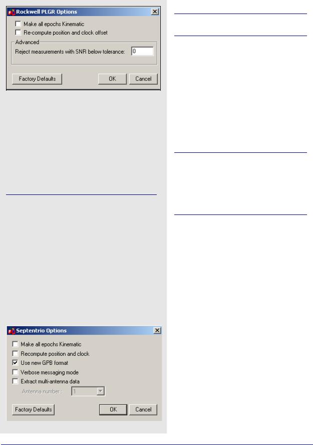
Rockwell PLGR/MPE12
This converter is available only in the Rockwell version of the software.
Table 27 describes the supported records.
Make all epochs Kinematic
Entire file will be set to kinematic mode.
Re-compute position and clock offset
GrafNav requires valid clock shift data, while GrafNet requires position records. Enable this option if the clock shift data is corrupt, or if positions records are not present.
Advanced
Reject measurements with SNR below tolerance
Satellites with low CNO will not be decoded.
Older versions of Rockwell Jupiter firmware did not make measurements on the even second. In order to make the data usable, the measurements need to be skewed to the even second by using Doppler measurements. Newer versions of the firmware have corrected this issue.
Septentrio SBF
Table 28 describes the records supported.
Make all epochs Kinematic
Entire file will be set to kinematic mode.
Re-compute position and clock
GrafNav requires valid clock shift data, while GrafNet requires position records. Enable this option if the clock shift data is corrupt, or if positions records are not present.
Use new GPB format
Converts data into NEW GPB format.
Verbose messaging mode
Allows you to see additional warning messages.
Extract multi-antenna data
For multi-antenna applications only.
240 |
GrafNav / GrafNet 8.10 User Guide Rev 4 |
Utilities |
Chapter 8 |
|
|
|
|
SiRF Binary
Table 29 describes the records supported.
General Options
Make epochs Kinematic
Entire file will be set to kinematic mode.
Verbose messaging mode
Allows you to see additional warning messages.
Reject satellite measurements with low C/No
Satellites with low C/No will not be decoded.
Re-compute receiver position and clock offset
GrafNav requires valid clock shift data, while GrafNet requires position records. Enable this option if the clock shift data is corrupt, or if positions records are not present.
Reject epoch if receiver clock offset is missing
Data is unusable if clock offset is missing. Clock offset can be re-computed using GPBView.
New firmware version with different representation of double precision
Time Alignment
Leave time raw
Enable for kinematic or single point processing. Master data can be interpolated on to remote using
Concatenate, Splice and Resample utility. See Section 8.3.1, on Page 226 for help.
Adjust time to nearest interval
Kinematic/code-only shift to interval equal to base data interval.
Interpolate to data interval
Enabled for static only. Interpolates data onto regular data interval.
Advanced Options
The following options are available:
Move Point/Attribute to start and end of static
Links Point only.
Use alternate ephemeris file
If ephemeris data is missing, select an alternate EPP file.
SiRF receivers do not make measurements on the whole epoch. Either master or remote data must be interpolated onto the other in order to process. See Section 8.3.1, on Page 226 for help.
Table 29: Records Supported for SiRF Binary
Record |
Type |
Comment |
|
|
|
|
|
28 |
Measurements |
Required. |
|
|
|
|
|
15 |
Ephemeris |
Required. |
|
|
|
|
|
7 |
Clock Offset |
Recommended. |
|
|
|
|
|
2 |
Position |
Recommended for |
|
GrafNet users. |
|||
|
|
||
|
|
|
GrafNav / GrafNet 8.10 User Guide Rev 4 |
241 |
Chapter 8 |
Utilities |
|
|
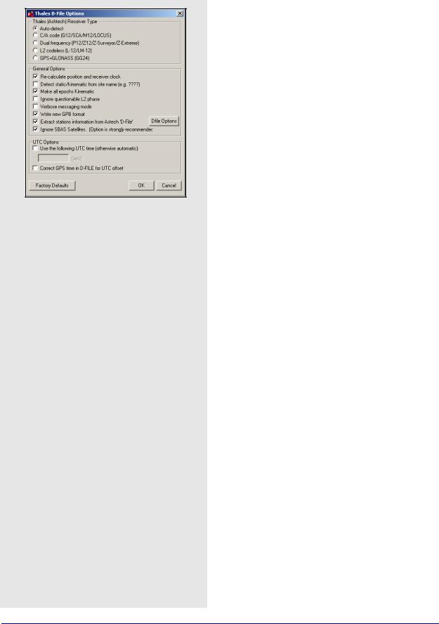
Thales B-File
This decoder handles Thales data that has been downloaded using the Thales utility. Log this data into internal receiver memory. Table 32 describes the supported files.
Thales (Ashtech) Receiver Type
Selects the receiver used to collect the data. If auto-detect does not work, then select the receiver manually.
General Options
Re-calculate position and clock offset
Thales receivers occasionally compute incompatible clock corrections. Enable this option if the clock shift data is corrupt, if positions records are not present or if many cycle slips exist.
Detect static/kinematic from site name
Looks in B-file for data tagged as static or kinematic, using ???? site ID.
Make epochs Kinematic
Entire file will be set to kinematic mode.
Ignore questionable L2 phase
Allows for processing of highest quality L2 data only.
Should be enabled if KAR is having difficulties.
Verbose messaging mode
Allows you to see additional warning messages.
Write new GPB format
Converts data into the new GPB format.
Extract stations information from Ashtech 'D-File'
Various Thales hand-held controllers output a D-file containing features and antenna height information. Enable this checkbox to utilize this information.
Ignore SBAS Satellites
Newer versions of Thales firmware have resulted in the logging of raw data from SBAS satellites, which are not supported by the software. As such, this option should be left enabled to ensure the data is not written to the GPB file.
UTC Options
Use the following UTC time
Changes the GPS to UTC time offset from the current nominal value to user-defined value. Normally used for GLONASS processing if no UTC is contained in the data.
Correct GPS time in D-FILE for UTC offset
D-files can have GPS or UTC time. This option changes time from UTC to GPS.
242 |
GrafNav / GrafNet 8.10 User Guide Rev 4 |

Utilities |
Chapter 8 |
|
|
|
|
Dfile Options
Chain Repeated Station Marks into 1 Static Session
Combines sessions that are repeated in the Seismark software into one session.
Do NOT Chain Marks that are more than n seconds apart
This value controls the time tolerance used in the previous setting. If two static periods are marked less than the amount apart, they will be combined.
Table 30: Files Supported for Thales B-File
|
File |
Type |
Comment |
|
|
|
|
|
BssssAyy.jjj |
Measurements |
Required. |
|
|
|
|
|
EssssAyy.jjj |
Ephemeris |
Required. |
|
|
|
|
|
SssssAyy.jjj |
Static Station |
Written to STA file. |
|
Information |
||
|
|
|
|
|
|
|
|
|
DssssAyy.jjj |
Kinematic Station |
Written to STA file. |
|
Information |
||
|
|
|
|
|
|
|
|
|
PHOTO.DAT |
Event Mark |
Read in directly by |
|
software. |
||
|
|
|
|
|
|
|
|
|
|
|
|
Thales files follow a strict naming convention. In the table above, ssss is the site name, yy is the last two digits of the year, and jjj is the day of the year.
Antenna heights may need to be edited within the feature editor if not kept constant, as the Thales format only allows for one value.
You might need to select receiver type manually.
GrafNav / GrafNet 8.10 User Guide Rev 4 |
243 |

Chapter 8 |
Utilities |
|
|
Table 31: Records Supported for Thales Real-Time
|
Record |
Type |
Comment |
|
|
|
|
|
MBN |
Measurements |
|
|
|
|
|
|
MCA |
Measurements |
|
|
|
|
|
|
MPC |
Measurements |
|
|
|
|
|
|
MCL |
Measurements |
|
|
|
|
|
|
MACM |
Measurements |
|
|
|
|
|
|
ITA |
Measurements |
One of these |
|
(C/A Code Only) |
||
|
|
records is required; |
|
|
|
|
see Note 1 |
|
CT1 |
Measurements |
|
|
|
||
|
(C/A Code Only) |
|
|
|
|
|
|
|
|
|
|
|
CT2 |
Measurements |
|
|
(C/A Code and |
|
|
|
|
L1 Phase) |
|
|
|
|
|
|
|
Measurements |
|
|
CT3 |
(C/A Code, L1 |
|
|
Phase and C/A |
|
|
|
|
|
|
|
|
Code) |
|
|
|
|
|
|
SNV |
Ephemeris |
Required. |
|
|
|
|
|
SNG |
Ephemeris |
Required for GLONASS |
|
(GLONASS) |
users. |
|
|
|
||
|
|
|
|
|
PBN |
Position |
See Note 2. |
|
|
|
|
|
|
|
|
1.The MBN or MACM records are recommended for G12 receivers. The MACM record is designed for high-speed data output that is, 10Hz or 20Hz, under limited bandwidth conditions. The ITA record is for G8 receivers, while the MPC is for dual frequency receivers, such as those in the Z-series. The MCL record is an L2 codeless record.
2. Marks the end of the record. Recommended for GrafNet users.
Thales Real-Time
This decoder converts Thales Real-Time (DG16, G12, or Super C/A) data. The real-time data forms when data is logged externally from the receiver using a utility such as WLOG or another custom data logger. Table 31 describes the supported records.
General Options
Make all epochs Kinematic
Entire file will be set to kinematic mode.
Recompute position and time
Enable this option if the clock shift data is corrupt, or if positions records are not present.
Write new GPB format
Converts data into the new GPB format.
Decode MACM messages and ignore others
If both MBN/MCA and MACM records exist, only the MACM will be decoded.
Decode old-style MBN locktime
Some older units (for example, Sensor II) output locktimes with a different resolution. Enable this option to output the locktime value.
Parthus MACM Settings
These settings are for logging MACM records:
Decode Parthus style MACM record
Parthus units (NS100, GSU-1, and GSU-2) utilize the MACM record. However, due to timing differences, its implementation is not compatible. Therefore, enable this option.
Data interval adjustment
The GSU-1 benefits greatly by having the correct data interval entered, while the GSU-2 is best processed using the raw time and having the base interpolated onto these times. See
Section 8.3.1, on Page 226 for help.
UTC Offset for GLONASS decoding
The following option is available for those users logging GLONASS measurements:
Use the following UTC offset for decoding
Allows you to define your own UTC offset rather than using the nominal or detected value. Important for GLONASS processing.
Alternate Ephemeris
The following option is available:
Use alternate ephemeris
Enable this option if ephemeris data is missing (for example, Parthus, GSU-2) to specify an outside EPP file.
244 |
GrafNav / GrafNet 8.10 User Guide Rev 4 |

Utilities |
Chapter 8 |
|
|
|
|
Thales DNSP
Table 32 describes the supported records.
The Measurement Q record includes the receiver time record, while the Measurement R record includes the satellite time record. As such, the former is recommended.
Make all epochs Kinematic
Entire file will be set to kinematic mode.
Write new GPB format
Converts data into the new GPB format.
Trimble DAT
This decoder converts data from Trimble 4000-5800 receivers. The Trimble data files (DAT) are formed when data is logged internally in the receiver.
The Table 33 describes the supported files.
Make all epochs Kinematic
Entire file will be set to kinematic mode.
Write new GPB format
Converts data into the new GPB format.
Recompute position and clock offset
Enable this option if the clock shift data is corrupt, or if positions records are not present.
The antenna height extracted by the decoder may be the slant distance.
Trimble SSF files cannot be directly decoded using this utility. As such, they must be converted to DAT or RINEX format first.
Trimble Real-Time
Data captured directly from a Trimble 4000-5800 receiver can also be converted to GPB using this decoder.
The Table 34 describes the records supported.
Make all epochs Kinematic
Sets file to kinematic mode.
Verbose messaging mode
Displays additional warning messages.
Write new GPB format
Converts data into the new GPB format.
Table 32: Records Supported for Thales DNSP
Record |
Type |
Comment |
|
|
|
|
|
Measurement Q |
Measurements |
|
|
(hex 51) |
One of these |
||
|
|||
|
|
records is required; |
|
Measurement R |
Measurements |
see Notes. |
|
(hex 52) |
|
||
|
|
||
|
|
|
|
Measurement E |
Ephemeris |
Required. |
|
(hex 45) |
|||
|
|
||
|
|
|
Table 33: Files Supported for Trimble DAT
File |
Type |
Comment |
|
|
|
*.dat |
Measurements, |
Required. |
Ephemeris and |
||
|
Event Marks |
|
|
|
|
Table 34: Records Supported for Trimble RealTime
Record |
Type |
Comment |
|
|
|
|
|
0x0 |
Measurement |
Required. |
|
|
|
|
|
0x1 |
Position |
Recommended for |
|
GrafNet users. |
|||
|
|
||
|
|
|
|
0x2 |
Ephemeris |
Required. |
|
|
|
|
GrafNav / GrafNet 8.10 User Guide Rev 4 |
245 |

Chapter 8 |
Utilities |
|
|
Table 35: Records Supported for Trimble TSIP
Record |
Type |
Comment |
|
|
|
|
|
0x9A |
Measurements |
One of these records |
|
|
|
||
0x6t |
Measurements |
is required, but 0x9A |
|
|
|
is recommended. |
|
0x5A |
Measurements |
||
|
|||
|
|
|
|
0x58 |
Ephemeris |
Required. |
|
|
|
|
|
0x4A |
Position |
Single precision. |
|
|
|
|
|
0x8A |
Position |
Double precision. |
|
|
|
|
Table 36: Records Supported for Trimble TIPY
Record |
Type |
Comment |
|
|
|
|
|
0xAE |
Measurements |
Required. |
|
|
|
|
|
0x84 |
Position |
Recommended for |
|
GrafNet users. |
|||
|
|
||
|
|
|
|
0x99 |
Ephemeris |
Required. |
|
|
|
|
|
0x44 |
Dilution of |
Not used in post- |
|
Precision |
processing. |
||
|
|||
|
|
|
Table 37: Records Supported for U-Blox
Record |
Type |
Comment |
|
|
|
|
|
ID #10 |
Measurements |
Required. |
|
|
|
|
|
ID #31 |
Ephemeris |
Required. |
|
|
|
|
|
ID #02 |
Position |
Recommended for |
|
GrafNet users. |
|||
|
|
||
|
|
|
|
ID #22 |
Clock Information |
Recommended. |
|
|
|
|
Trimble TSIP
Data in Trimble's TSIP format is converted with this decoder. Receivers that support this format include Ag20, MS-750 and MD-950. Table 35 describes the supported records.
Make all epochs Kinematic
Entire file will be set to kinematic mode.
Verbose messaging mode
Allows you to see additional warning messages.
Reverse sign on receiver clock bias
Opposite sign will be applied to receiver clock bias.
Trimble TIPY
This decoder converts data from Trimble’s Force 5 receiver. Carrier phase measurements may not be usable. Table 36 describes the supported records.
Make all epochs Kinematic
Entire file will be set to kinematic mode.
Skew measurements to top of second
Shifts times to whole second to make differential possible. However, you may also wish to consider leaving the times raw and interpolating the master file onto the remote. See
Section 8.3.1, on Page 226 for help.
Re-compute position and clock offset
GrafNav requires valid clock shift data, while GrafNet requires position records. Enable this option if the clock shift data is corrupt, or if positions records are not present.
Verbose messaging mode
Displays additional warning messages.
Input alternate ephemeris
If ephemeris missing or incomplete, enable this setting to specify an outside EPP file.
Shift (corrected) measurement time
Apply time correction to measurements. This is used to correct a bug in older versions of the Trimble firmware.
U-Blox
Table 37 describes the supported records.
Make all epochs kinematic
Entire file will be set to kinematic mode.
Recompute position and time
GrafNav requires valid clock shift data, while GrafNet requires position records. Enable this option if the clock shift data is corrupt, or if positions records are not present.
Use new GPB Format
Converts data into new GPB format.
Verbose messaging mode
Displays additional warning messages.
246 |
GrafNav / GrafNet 8.10 User Guide Rev 4 |