

Требования к операционной системе
Поддерживаемые операционные системы |
Windows 8.1 Basic, Professional и Enterprise (32-разрядная и 64разрядная [EM64T]) Поддержка Windows 8.1 and Windows Server 2012 R2 начинается с версии ArcGIS 10.2.1. |
Windows 8 Basic, Professional и Enterprise (32-разрядная и 64разрядная [EM64T]) |
Windows 7 Ultimate, Enterprise, Professional, Home Premium (32разрядная и 64-разрядная [EM64T]) SP1 |
Microsoft Windows Server 2003, 2003 R2, Vista и XP не поддерживаются, начиная с версии ArcGIS 10.2.2.
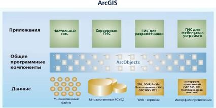
Семейство программных продуктов ArcGis
ArcGIS for Desktop, ArcGIS Pro – настольные ГИС
ArcGIS for Server – серверные ГИС
ArcGIS for Online – web ГИС
ArcGIS for Mobile Devices – ГИС для мобильных устройств
ArcGIS for Developers – ГИС для разработчиков
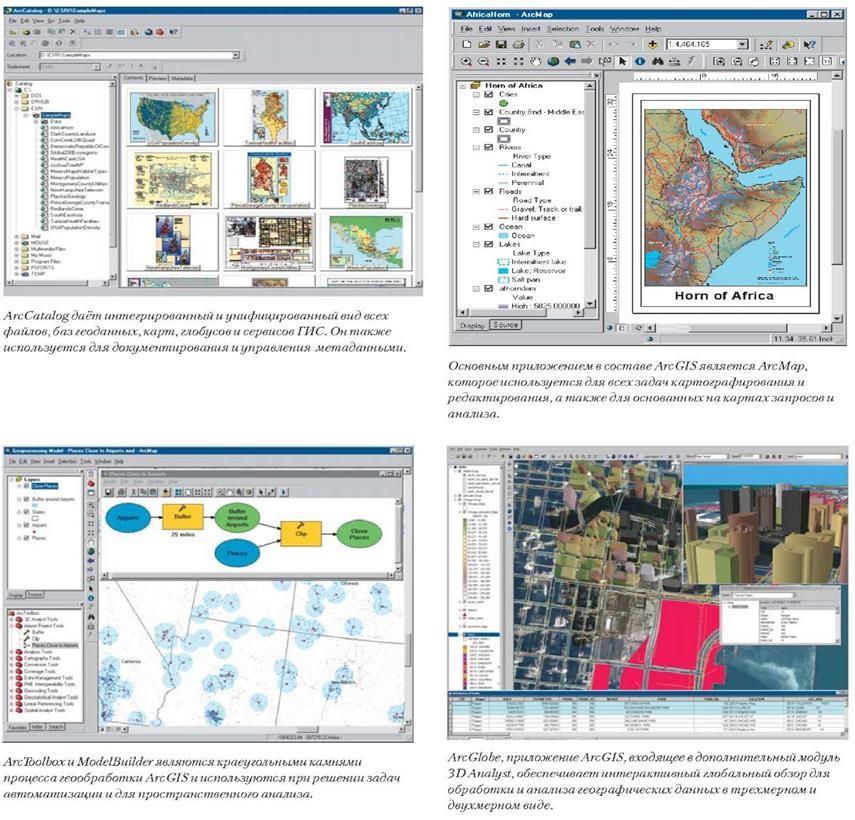
ArcGIS for Desktop
ArcGIS for Desktop Basic – базовая версия для работы с цифровыми картами и их анализом.
ArcGIS for Desktop Standard – добавлены возможности по созданию и редактированию баз геоданных.
ArcGIS for Desktop Advanced – полнофункциональная профессиональная версия с большими возможностями ГИС-анализа и обработки пространственных данных.
Дополнительные модули
Название модуля |
Функциональные возможности модуля |
ArcGIS 3D Analyst extension |
ArcGlobe: Interactive 3D scenes Globe views in ArcCatalog Globe publishing in ArcGIS Publisher 3D raster and TIN modeling tools Publish globe services Lidar and terrain datasets |
ArcGIS Business Analyst |
Customer and store prospecting Market penetration analysis Drive-time analysis Business and demographic data |
ArcGIS Data Interoperability |
Directly read, transform, and export any data format Tools for data transformation and direct use |
ArcGIS Data Reviewer |
Analyze and validate data using checks Store and interact with validation and analysis results in the Reviewer table Generate reports based on check results |
ArcGIS Geostatistical Analyst |
Advanced kriging and surface modeling Exploratory spatial data analysis tools Probability, threshold, and error mapping |
ArcGIS Network Analyst extension |
Network and transportation analysis Minimum path, closest facility, allocate, and traveling salesman Advanced network data modeling and simulation |
ArcGIS Publisher |
Publish Map and Globe documents for use with the free ArcReader application Package and compress data Optional data compression and locking Developer SDK for customizing ArcReader |
ArcScan |
Perform raster-to-vector conversion tasks on scanned documents Raster editing, snapping, and tracing tools |
ArcGIS Schematics |
Database-driven schematic rendering and display Schematic views of GIS networks and tabular information Multiple schematic representations |
ArcGIS Spatial Analyst extension |
Advanced raster and vector tools Spatial modeling Map Algebra |
Esri Aeronautical Solution |
Create features based on inputs such as airspace Tools for ICAO-compliant chart creation Data sharing with the aeronautical information exchange model (AIXM) |
Esri Defense Mapping |
Data models, topologies, and business rules for production of defense data Streamline data publication with standardized symbology and map templates Support for several data specifications |
Esri Nautical Solution |
Generate electronic, hard-copy, and raster navigational products that are compliant with hydrographic organization standards Integrated S-58 checks Use predefined symbology and grids to create nautical charts |
Esri Production Mapping |
Data creation, maintenance, and validation tools Tools to create complex feature templates with multiple geometry types Data validation and analysis with checks Cartographic production tools |
ArcGIS Tracking Analyst |
Time-based map displaying and rendering Playback tools (play, pause, forward, and rewind) Work with time-based data (features whose geometry or attributes move and change) |
ArcGIS Workflow Manager |
Create and manage workflows for an enterprise environment Track workflow progress across multiple servers Define workflows based on areas of interest |