
- •Textbook Series
- •Contents
- •1 Definitions
- •Introduction
- •Abbreviations
- •Definitions
- •2 International Agreements and Organizations
- •The Chicago Convention
- •International Law
- •Commercial Considerations
- •Customs and Excise, and Immigration
- •International Obligations of Contracted States
- •Duties of ICAO Member States
- •Status of Annex Components
- •The International Civil Aviation Organization (ICAO)
- •The Organization of ICAO
- •Regional Structure of ICAO
- •Regional Structure and Offices
- •ICAO Publications
- •Other International Agreements
- •The Conventions of Tokyo, the Hague and Montreal
- •The Warsaw Convention
- •The Rome Convention
- •IATA
- •ECAC
- •EASA
- •Eurocontrol
- •World Trade Organization
- •Geneva Convention
- •EU Regulation 261/2004
- •Questions
- •Answers
- •3 Airworthiness of Aircraft
- •Introduction
- •Airworthiness
- •Questions
- •Answers
- •4 Aircraft Nationality and Registration Marks
- •Introduction
- •Nationality and Registration Marks
- •Certification of Registration
- •Aircraft Markings
- •Classification of Aircraft
- •Questions
- •Answers
- •5 Flight Crew Licensing
- •Introduction
- •Definitions
- •General Rules Concerning Licensing
- •Licences and Ratings for Pilots
- •Multi-crew Pilot Licence (MPL)
- •Instrument Rating (Aeroplane) (IR(A))
- •Instructor and Examiner Rating
- •JAR-FCL 3 Medical Requirements
- •Pilot Proficiency
- •EASA Theoretical Knowledge Examinations
- •Questions
- •Answers
- •6 Rules of the Air
- •History
- •Applicability of the Rules of the Air
- •General Rules
- •Visual Flight Rules
- •Instrument Flight Rules
- •Semi-circular Flight Level Rules and RVSM
- •Special VFR
- •Distress and Urgency Signals
- •Restricted, Prohibited or Danger Areas
- •Signals for Aerodrome Traffic
- •Marshalling Signals
- •Flight Deck Signals
- •Questions
- •Answers
- •Instrument Procedures
- •PANS OPS
- •Instrument Departure Procedures
- •Questions
- •Answers
- •8 Approach Procedures
- •Procedure Basics
- •Approach Procedure Design
- •Obstacle Clearance Altitude/Height
- •Operating Minima
- •Descent Gradients
- •Track Reversal and Racetracks
- •Missed Approach Segment and Procedure
- •Published Information
- •RNAV Approach Procedures based on VOR/DME
- •Questions
- •Answers
- •9 Circling Approach
- •Circling Approach
- •Questions
- •Answers
- •10 Holding Procedures
- •Holding Procedures
- •Entry Sectors
- •ATC Considerations
- •Obstacle Clearance
- •Questions
- •Answers
- •11 Altimeter Setting Procedure
- •Altimeter Setting Objectives
- •Transition
- •Phases of Flight
- •Questions
- •Answers
- •12 Parallel or Near-parallel Runway Operation
- •Safety
- •Runway Spacing
- •Questions
- •Answers
- •13 SSR and ACAS
- •Airborne Collision Avoidance System (ACAS)
- •Questions
- •Answers
- •14 Airspace
- •Introduction
- •Control Areas and Zones
- •Classes of Airspace
- •Required Navigation Performance (RNP)
- •Airways and ATS Routes
- •Questions
- •Answers
- •15 Air Traffic Services
- •Introduction
- •Air Traffic Control
- •ATC Clearances
- •Control of Persons and Vehicles at Aerodromes
- •The Flight Information Service
- •The Alerting Service
- •Procedures
- •Questions
- •Answers
- •16 Separation
- •Concept of Separation
- •Vertical Separation
- •Horizontal Separation
- •Radar Separation
- •Procedural Wake Turbulence Separation
- •Radar Wake Turbulence Separation
- •Visual Separation in the Vicinity of Aerodromes
- •Stacking
- •Questions
- •Answers
- •17 Control of Aircraft
- •Procedural ATC
- •Radar Control
- •Radar Identification
- •Radar Service
- •Aerodrome Control
- •Approach Control Service
- •Air Traffic Advisory Service
- •Aircraft Emergencies
- •Questions
- •Answers
- •18 Aeronautical Information Service (AIS)
- •Introduction
- •General
- •The Integrated Aeronautical Information Package
- •The Aeronautical Information Publication (AIP)
- •Notices to Airmen (NOTAM)
- •SNOWTAM
- •ASHTAM
- •Aeronautical Information Circulars (AICs)
- •Pre-flight and Post-flight Information
- •Questions
- •Answers
- •Introduction
- •Aerodrome Reference Code
- •Glossary of Terms
- •Aerodrome Data
- •Runways
- •Taxiways
- •Aprons
- •Questions
- •Answers
- •Requirements
- •Visual Aids for Navigation
- •Runway Markings
- •Taxiway Markings
- •Signs
- •Markers
- •Visual Docking Guidance Systems
- •Questions
- •Answers
- •21 Aerodrome Lighting
- •Aerodrome Lights
- •Approach Lighting Systems
- •Runway Lighting
- •Taxiway Lighting
- •Questions
- •Answers
- •22 Obstacle Marking and Aerodrome Services
- •Introduction
- •Visual Aids for Denoting Obstacles
- •Visual Aids for Denoting Restricted Use Areas
- •Emergency and Other Services
- •Other Aerodrome Services
- •Questions
- •Answers
- •23 Facilitation
- •Entry and Departure of Aircraft
- •Questions
- •Answers
- •24 Search and Rescue
- •Definitions and Abbreviations
- •Establishment and Provision of SAR Service
- •Co-operation between States
- •Operating Procedures
- •Questions
- •Answers
- •25 Security
- •Introduction
- •Objectives
- •Organization
- •Preventative Security Measures
- •Management of Response to Acts of Unlawful Interference
- •Further Security Information
- •Questions
- •Answers
- •26 Aircraft Accident and Incident Investigation
- •Introduction
- •Objective of Investigation
- •Investigations
- •Serious Incidents
- •EU Considerations
- •Questions
- •Answers
- •27 Revision Questions
- •Revision Questions
- •Answers
- •EASA Specimen Examination
- •Answers to Specimen EASA Examination
- •28 Addendum – EASA Part-FCL & Part-MED
- •Chapter Five. Flight Crew Licensing
- •European Aviation Safety Agency (EASA)
- •Licences
- •Ratings
- •Certificates
- •EASA Part-MED
- •29 Index
Separation 16
16.10Same Destination. If practicable, cruising levels of aircraft bound for the same destination will be assigned to facilitate the correct approach sequence at the destination.
16.11Priority. An aircraft at a cruising level will have priority over aircraft requesting that level. When two or more aircraft are at the same level, the preceding aircraft will have priority
16.12Allocation Separation. An aircraft may be assigned a level previously occupied by another aircraft after the latter has reported vacating it. In the case of severe turbulence or cruise climb, the assignment will be withheld until the other aircraft has reported at another level separated by the required minimum.
16.13Vertical Separation During Ascent or Descent. Pilots in direct communication with each other may, with their concurrence, be cleared to maintain a specified vertical separation between their aircraft during ascent or descent.
16.14Clearance to Maintain Own Separation in VMC. If requested by the pilot of an aircraft and it is agreed by the pilot of the other aircraft and authorized by ATC, a flight operating in classes D and E airspace in VMC during daylight, may be cleared to climb or descend maintaining own separation from one other aircraft providing:
•The clearance is specifically for the portion of flight below 10 000 ft;
•Alternative instructions are passed to the pilot to cover loss of VMC;
•If conditions deteriorate to the limits of VMC, the pilot is to inform ATC that he/she is complying with the alternative instructions.
Horizontal Separation
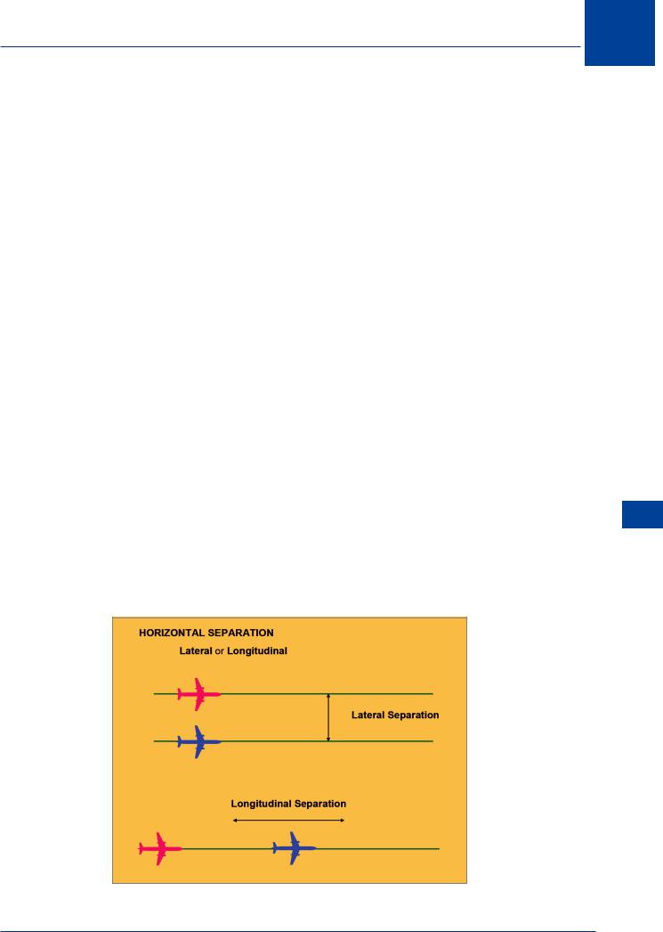
16.15 Definition. Horizontal separation relates to the distance between aircraft in the horizontal plane. This may be:
•Longitudinal (aircraft following the same route), where the separation standard is based on time (or distance) along track between aircraft, or
•Lateral.
Separation 16
Figure 16.2
293
16 Separation
Separation 16
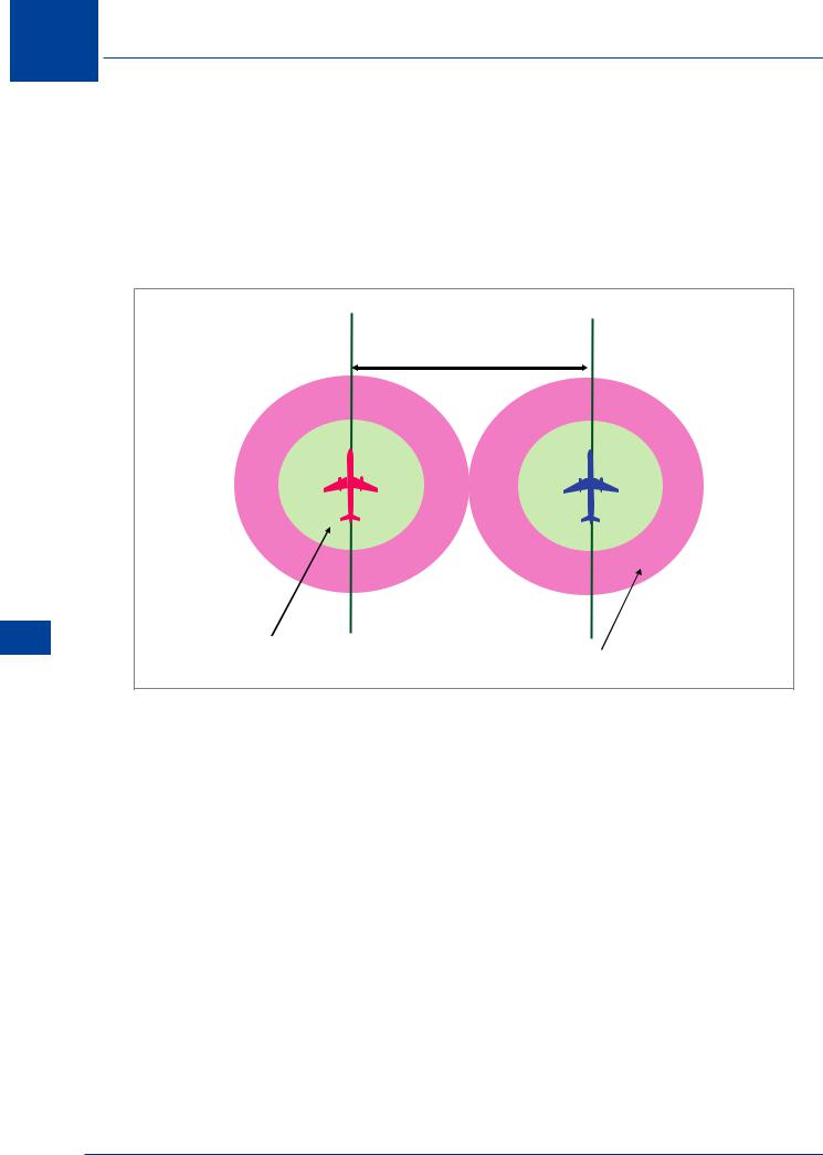
16.16 Lateral Separation. Lateral separation shall be applied so that the distance between those portions of the intended routes for which the aircraft are to be laterally separated is never less than an established distance to account for navigational inaccuracies plus a specified buffer. This buffer shall be determined by the appropriate authority and included in the lateral separation minima. Lateral separation of aircraft at the same level is obtained by requiring operation on different routes or in different geographical locations as determined by visual observation, by use of navigation aids or by use of area navigation (RNAV) equipment. The ‘buffer’ concept is applied to all methods of separation.
Minimum lateral separation
Position accuracy ‘area’ |
Safety “BUFFER” area |
|
Figure 16.3
16.17 Lateral Separation Criteria and Minima. Means by which lateral separation may be achieved include the following:
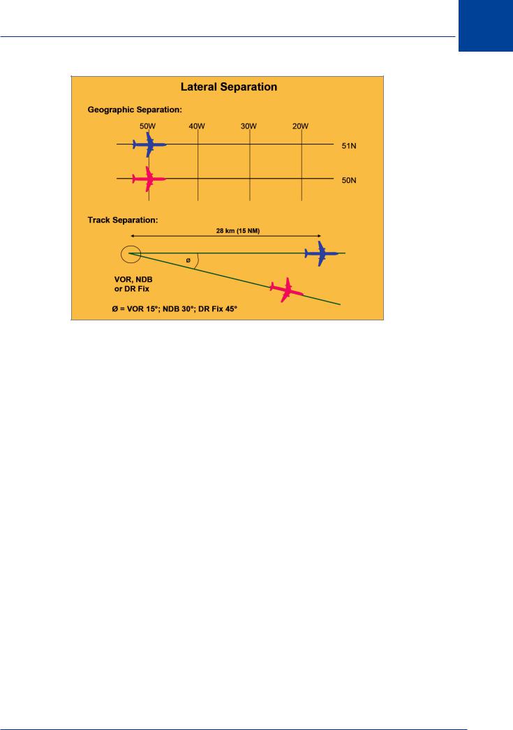
•Geographical Separation. Separation positively indicated by position reports over different geographical locations as determined visually or by reference to a navigation aid.
•Track Separation. This can be achieved between aircraft using the same navigation aid or method. It is achieved by requiring aircraft to fly on specified tracks which are separated by a minimum amount (angle and distance) appropriate to the navigation aid or method employed as follows. For the three cases specified the distance required is 15 NM from the common position with track divergence as follows:
•VOR: Track divergence 15°
•NDB: Track divergence 30°
•DR Fix: Track divergence 45°
294
Separation 16
|
Figure 16.4 Lateral separation |
|
16.18 |
Different Navigation Aids. Lateral separation between aircraft using different |
|
navigation aids, or where one aircraft is using RNAV equipment, is to be established by ensuring |
|
|
that the derived protected airspaces (buffer areas) do not overlap. |
|
|
16.19 |
RNAV Operations. Within designated airspace or on parallel routes where RNP is |
|
16 |
||
specified, lateral separation between RNAV aircraft may be obtained by requiring aircraft to |
|
|
Separation |
||
be established on the centre lines of parallel tracks or ATS routes spaced at a distance which ensures that the protected airspaces do not overlap. This is the policy that determines the spacing of the NAT tracks employed in the NAT MNPSA.
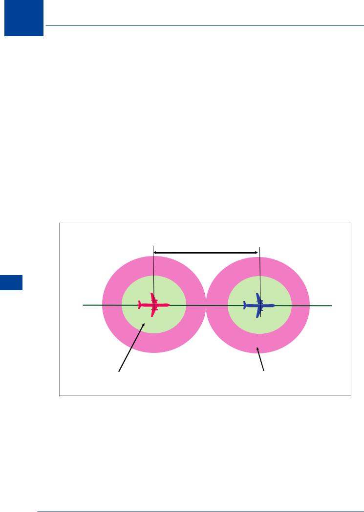
16.20 Longitudinal Separation. Longitudinal separation is the most complex application of separation standards. In procedural ATC (not radar control) the position of the aircraft is that which is reported by the pilot. The positions reported are usually specified reporting points, radio navigation facilities, or geographic points for routes not specified by navigation aids. In any event, the position known to the ATCO is only as good as that reported by the pilot. In applying procedural separation, all possible errors must be allowed for and then a safety margin (buffer) applied. The only situation in which the safety margins may be relaxed is where the pilots of aircraft to which separation should be applied have (and confirmed) that they have visual contact with each other and that they can maintain visual contact during the necessary manoeuvre to which separation would otherwise be applied. Clearly, the separation standards assume operations in IMC. The accuracy of pilot position reporting relies on the accuracy of the navigation system in use. In remote areas (over the oceans and desert regions) where RNAV procedures may be used, greater protection needs to be applied. Longitudinal separation applied is either in terms of time or distance.
295
16 Separation
16.21 Application. Longitudinal separation is applied so that the spacing between the estimated positions of the aircraft being separated is never less than a prescribed minimum. Longitudinal separation between aircraft following the same or diverging tracks may be maintained by application of the Mach number technique, when so prescribed on the basis of RAN agreement. Longitudinal separation is established by requiring aircraft to depart at a specific time, to lose time, to arrive over a geographical location at a specified time, or to hold over a geographical location until a specified time. For the purpose of the application of longitudinal separation, the following terms are defined:
•Same track. The same track case applies when the tracks of two aircraft that require separation, converge or diverge by an angular difference less than 45°, or more than 315° and whose protection areas overlap.
•Reciprocal track. The reciprocal track case applies when the tracks of two aircraft that require separation, converge or diverge by an angular difference more than 135° but less than 225° and whose protection areas overlap.
•Crossing tracks. When there is an angular difference between tracks of 45° or more but not exceeding 315° (ie : 045 to 135 degrees or 225 to 315 degrees).
Minimum longitudinal separation |
|
16 |
|
Separation |
|
Position accuracy ‘area’ |
Safety “BUFFER” area |
|
|
Figure 16.5 Longitudinal separation |
|
16.22Time Based Longitudinal Separation. The separation standards applied depend upon whether the aircraft concerned are maintaining the same level, or are climbing/descending.
16.23Same Level. In this situation the separation is dependent upon the track case:
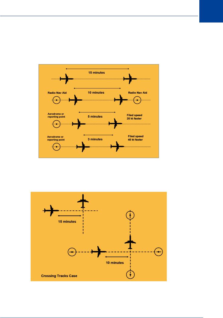
•Same track case. The basic standard is that aircraft should be at least 15 minutes apart. If, however, navigation aids for the route being flown permit frequent determination of position and speed, the basic standard may be reduced to 10 minutes. The standard my be further reduced to 5 minutes providing the aircraft have departed from the same aerodrome, or
296
Separation 16
passed over the same en route reporting point, or reported over a fix that is located relative to the departure point, to ensure that 5 minutes separation can be established at the point the departing aircraft will join the route, with the overriding proviso that the preceding aircraft has TAS 20 kt or more faster than the succeeding aircraft. If the speed difference is increased to 40 kt, the standard may be further reduced to 3 minutes.
Figure 16.6
• Crossing tracks case. The basic standard is 15 minutes. If, however, the frequent |
16 |
|||
determination of position and speed caveat applies, the standard may be reduced to 10 |
||||
|
||||
minutes. |
Separation |
|||
|
|
|
||
|
|
|
||
|
|
|
|
|
Figure 16.7
297
16 Separation
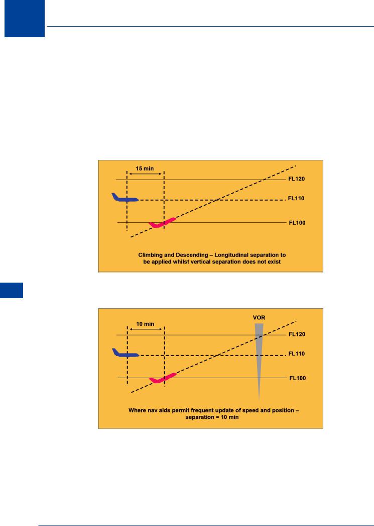
16.24 Climbing or Descending. This is a more complex case. The problem only exists when vertical separation does not exist (the aircraft are within the vertical separation standard of each other). Again it depends upon the relative tracks of the aeroplanes but now also involves the reciprocal track case.
•Same track. When an aircraft will pass through the level of another aircraft on the same track, the separation applied is 15 minutes, but may be reduced to 10 minutes provided that navigation aids permit frequent update of position and speed (and approved by the authority); or 5 minutes provided that the level change is commenced within 10 minutes of the time that the second aircraft has reported over an exact reporting point.
Figure 16.8
Separation 16
Figure 16.9
298
Separation 16
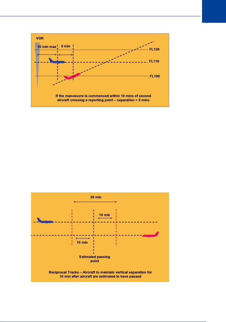
Figure 16.10
Note: If the level change involved is considerable, an intermediate level just above or just below (depending on the case - climb or descend) may be allocated to the manoeuvring traffic. Once at that level, separation will be assessed and if applied, the level crossing manoeuvre approved and executed.
• |
Crossing tracks. The applicable standard is 15 minutes unless frequent update of position |
|
||
|
and speed is available, in which case the minimum is reduced to 10 minutes. |
|
||
• |
Reciprocal tracks. Where lateral separation is not provided, vertical separation shall be |
|
||
|
provided for at least 10 minutes prior to and after the time the aircraft are estimated to |
|
||
|
have passed. Once it has been established (usually visually) that the aircraft have indeed |
16 |
||
|
passed, this minimum need not then further apply. |
|||
|
|
|||
|
Separation |
|||
|
|
|
|
|
|
|
|
|
|
|
|
|
|
|
Figure 16.11
299

16 Separation
Separation 16
16.25 Longitudinal Separation Based on DME. Where DME information is available, separation can be established by maintaining not less than the specified distances between aircraft positions. In this case it is a requirement that direct pilot - controller communication is maintained.
Note: in the NAT region using HF, communication is via a radio operator not direct to the controller.
16.26 Aircraft at the Same Level. The previously defined same and crossing track situations apply:
•Same track. The normal standard is 20 NM provided each aircraft uses on-track DME stations and separation is checked by obtaining simultaneous DME readings from the aircraft at frequent intervals. The standard may be reduced to 10 NM provided the leading aircraft maintains a TAS 20 kt or more, faster than the succeeding aircraft.
•Crossing tracks. The same track standards apply to crossing traffic providing that each aircraft reports distance from the station located at the crossing point and that the relative angle of the tracks is less than 90°.
•Climbing or descending. The standard separation is 10 NM whilst vertical separation does not exist, providing each aircraft uses ‘on-track’ DME stations; one aircraft maintains a level whilst vertical separation does not exist, and separation is established by simultaneous DME readings from the aircraft.
•Reciprocal tracks. Aircraft using on-track DME may be cleared to climb or descend to or through levels occupied by other aircraft using on-track DME, provided it has been positively established that the aircraft have passed each other and are at least 10 NM apart (or such other value as the authority specifies).
16.27 Longitudinal Separation with Mach Number Technique Based on Time. The Mach number technique requires turbojet aircraft to fly at the Mach number approved by ATC, and to request approval before making any speed changes. If it is essential to make immediate temporary changes to speed (e.g. due to turbulence), ATC is to be informed as soon as possible. If it is not feasible due to aircraft performance to maintain the last assigned Mach number during en route climbs and descents, pilots are to advise ATC at the time clearance to climb or descent is requested. Separation will be deemed to exist when the required time interval exists providing:
•The aircraft concerned have reported over the same reporting point and follow the same track or continuously diverging tracks until some other form of separation is provided, or
•It is possible to ensure, by radar or other means, that the appropriate time interval will exist at the common point from which they will either follow the same track or continuously diverge, if the aircraft have not already reported over the same point.
16.28 Time Intervals. When the Mach number technique is applied, minimum longitudinal separation between turbojet aircraft on the same track, whether in level, climbing or descending flight is:
•10 minutes providing the preceding aircraft maintains a Mach speed equal to or greater than that maintained by the following aircraft, or
300

Separation 16
•Between 9 and 5 minutes inclusive, providing the preceding aircraft is maintaining a Mach number greater than the following aircraft in accordance with the following:
Mach No. difference |
Longitudinal Separation |
|
between preceding and |
||
standard |
||
following |
||
|
||
|
|
|
0 |
10 minutes |
|
|
|
|
0.01 |
10 minutes |
|
|
|
|
0.02 |
9 minutes |
|
|
|
|
0.03 |
8 minutes |
|
|
|
|
0.04 |
7 minutes |
|
|
|
|
0.05 |
6 minutes |
|
|
|
|
0.06 |
5 minutes |
|
|
|
Figure 16.12 Mach number separation
16.29 Longitudinal Separation Based on RNAV. This is applicable to RNAV aircraft operating along RNAV routes or ATS routes defined by VOR. In this case, separation is established by maintaining the specified distance between aircraft positions reported by reference to the RNAV equipment. It is a requirement that direct controller/pilot communications are maintained. RNAV positions are defined as standard way points common to both aircraft subject to separation. The minimum is 150 km (80 NM) distance based separation instead of the normally required 10 minutes. It is also essential that the Mach number technique is applied. In the event of equipment failure reducing the navigation capability to less than the RNAV requirement, the normal longitudinal separation will be applied. The specific separation requirements are:
•Same cruising level. 150 km (80 NM) providing each aircraft reports position from same point and separation is checked by obtaining simultaneous RNAV distance readings from the aircraft at frequent intervals.
•Climbing or descending on same track. 150 km (80 NM) whilst vertical separation does not exist, provided each aircraft reports distance from same way point, one aircraft maintains level flight whilst vertical separation does not exist, and separation is established by obtaining simultaneous RNAV distance readings from the aircraft.
•Reciprocal tracks. Aircraft may be permitted to climb or descend through levels occupied by other aircraft providing it has been positively established by simultaneous RNAV distance readings to or from the same on-track way point that the aircraft have passed each other by at least 150 km (80 NM).
Separation 16
301

16 Separation
Separation 16
16.30 Longitudinal Separation Based on RNAV where RNP is Specified. For aircraft cruising, climbing or descending on the same track in an RNP RNAV environment, the separation standards detailed in the table below may be used. During the application of the 50 NM minimum, if an aircraft fails to report its position, the controller is to take action within 3 minutes to establish communications. If communication has not been established within 8 minutes, alternative separation is to be applied. An aircraft may climb or descend through an occupied level once it has been established that the aircraft concerned have passed.
|
Communication |
Surveillance |
Distance |
|
|
RNP Type |
Verification |
Separation |
|||
Requirement |
Requirement |
||||
|
Requirement |
|
|||
|
|
|
|
||
20 |
Direct pilot/controller |
Procedural |
At least every 60 |
80 NM |
|
communications |
Position Reports |
minutes |
|||
|
|
||||
|
|
|
|
|
|
10 |
Direct pilot/controller |
Procedural |
At least every 30 |
50 NM |
|
communications |
Position Reports |
minutes |
|||
|
|
||||
|
|
|
|
|
Figure 16.13 RNP RNAV separation
16.31 Reduction in Separation Minima. The separation minima may be reduced as determined by the appropriate ATS authority, after prior consultation with the aircraft operators, as appropriate, in the following circumstances:
•When special electronic or other aids enable the pilot-in-command of an aircraft to determine accurately the aircraft’s position and when adequate communication facilities exist for that
position to be transmitted without delay to the appropriate air traffic control unit; or
•When, in association with rapid and reliable communication facilities, radar-derived information of an aircraft’s position is available to the appropriate air traffic control unit; or
•When special electronic or other aids enable the air traffic controller to predict rapidly and accurately the flight paths of an aircraft and adequate facilities exist to verify frequently the actual aircraft positions with the predicted positions; or
•When RNAV-equipped aircraft operate within the coverage of electronic aids that provide the necessary updates to maintain navigational accuracy.
•In accordance with RAN agreements, after prior consultation with the aircraft operators, when:
•Special electronic, area navigation and other aids enable the aircraft to closely adhere to their current flight plans; and
•The air traffic situation is such that the conditions regarding communications between pilots and the appropriate ATS unit or units need not necessarily be met to the degree specified therein, in order to maintain an adequate level of safety.
302
