

Airspace
Control Areas and Zones
14.6CTAs and CTRs. Air Traffic Control is only provided inside what is known as controlled airspace (CAS). It is generally accepted that the upper limit of CAS is defined as FL660. CAS comprises CTAs and CTRs. The primary function of CTAs/CTRs is to facilitate ATC to IFR traffic.
14.7CTAs. A CTA is airspace within which ATC is provided to controlled flights (see definition) which are ‘en route’ (i.e. not in the departure or approach phases of a flight). The service provided in a CTA is Area Control and is discussed in detail in Chapter 17. CTAs are usually established in the vicinity of major aerodromes and at the confluence of airways. As already mentioned, the linking corridors of airspace (airways) are also CTAs. CTAs are defined to exist from a level above ground level (AGL) to an altitude or FL. Where the limit of a CTA is defined as a FL, it will be a VFR FL. The lowest level of a CTA must be at least 200 m (700 ft) AGL. The airspace within a CTA may be sub-divided to allow different types of operation to exist. The upper portion of a CTA will be predominantly for traffic that is in transit whilst the lower levels will be dedicated to aircraft entering the ‘manoeuvring ‘ airspace from above or leaving it. The lower part of the CTA will be used to route aircraft arriving to the individual IAFs for instrument approaches, and to separate departing aircraft from one aerodrome from arriving traffic to another.
14.8CTRs. CTRs are established in the vicinity of aerodromes to provide ATC to arriving and departing controlled traffic. Within a CTR the ATC service is provided by Approach controllers and is mandatory. A CTR may serve more than one aerodrome. Because a CTR is a zone, the base of any zone is defined as ground level or MSL. Where the upper limit is defined as a FL it would always be a VFR FL. A CTR should be big enough to encompass the airspace required to provide the service and will usually extend at least 5 NM from the aerodrome reference position in the direction from which approaches are made. If established within the lateral limits of a CTA, the CTR must extend upwards to the lower limit of the CTA.
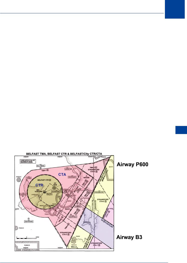
Figure 14.3
14
Airspace 14
259

14 Airspace
14.9 Upper Control Areas. Where a CTA extends above FL195, the rules applicable may be those pertaining to the lower airspace.
14.10 Control Units. The provision of ATC to flights in CAS is the responsibility of the air traffic control units (ATCUs) within the designated airspace. Area Control Centres provide ATC within CTAs and Approach Control Units and Aerodrome Control Towers provide the service required in CTRs.
|
Classes of Airspace |
|
|
14.11 Introduction. In 1980, ICAO introduced a uniform system of classification of airspace |
|
|
to replace the disparate systems of airspace reservations throughout the world. The ICAO |
|
|
system classifies airspace in 7 categories from A to G each class dependent upon the rules |
|
|
applicable, the ATC service provided, separation standards applicable and the utilization of the |
|
|
airspace. |
|
|
14.12 Controlled Airspace (CAS). Classes A - E are classified as controlled airspace within |
|
|
which air traffic control is provided to controlled flights. In these classes, IFR flights are always |
|
|
controlled flights. In classes A and B all permitted flights are controlled whereas in classes C and |
|
|
D, ATC is provided to VFR traffic only when conflicting with IFR traffic. CAS is defined as CTAs |
|
|
(including airways) and CTRs. ICAO states that class E airspace cannot be used as a CTR. |
|
|
14.13 Advisory Airspace. Class F airspace is defined as advisory airspace in which advisory |
|
14 |
ATC is provided to IFR traffic which requests the service (participating traffic). All IFR traffic |
|
flying in class F airspace is required to file a FP but no ATC clearance will be issued. The service is |
||
|
||
Airspace |
||
Class F airspace is considered to be temporary, established during a trial period whilst it is |
||
|
limited to the provision of advice and information and only participating flights are separated. |
|
|
determined if a full ATC service is applicable. |
|
|
14.14 SVFR. All classes of airspace which support the establishment of a CTR permit flight |
|
|
under SVFR. SVFR is covered in detail in chapter 6 - Rules of the Air. |
|
|
14.15 Non-radio. Classes E - G permit VFR traffic to fly without VHF 2-way RTF communications. |
|
|
In areas where the ATC authority consider that the provision of the alerting service is essential |
|
|
(over remote areas or over expansive areas of sea), routes may be established along which |
|
|
(at the appropriate altitude) 2-way RTF communications will be available and traffic will be |
|
|
advised to maintain radio contact with an air traffic services unit. |
|
|
14.16 Speed Limit. A speed limit of 250 kt IAS is applied to VFR traffic in class C and all traffic |
|
|
in classes D - G. The limit is applicable to traffic flying below 10 000 ft (FL100) only. |
|
|
14.17 Flight Information Service (FIS). In classes C - G, a Flight Information Service is |
|
|
available to aircraft that either request the service, or are otherwise known to ATC. This service |
|
|
provides collision alerts but leaves it to the pilot to take the necessary (as per the rules of the |
|
|
air) avoiding action. Information considered necessary relating to collision avoidance is known |
|
|
as traffic information. In classes A and B airspace, FIS is available but is of a lesser priority to |
|
|
the provision of ATC. Where the provision of traffic information is considered to be of the |
|
|
same priority as ATC, the traffic concerned is known as ‘essential traffic,’ and the information |
|
|
relating to such traffic is called ‘essential traffic information.’ |
|
|
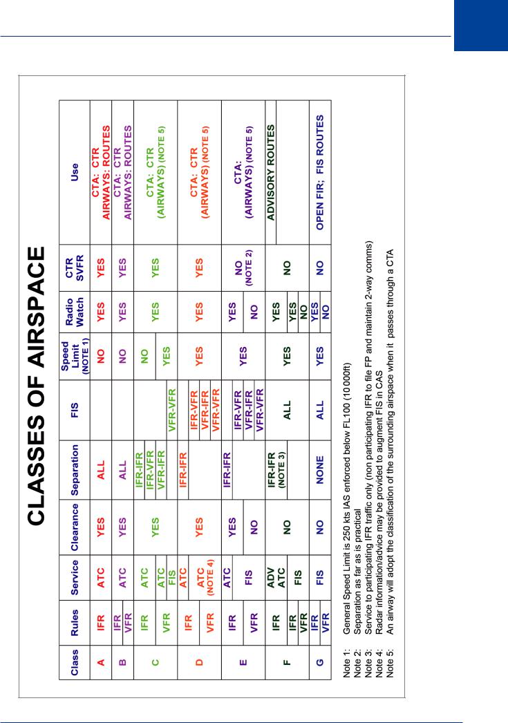
14.18 Airspace Summary. The table below summarizes the requirements and restrictions of |
|
|
the 7 classes of airspace. |
260
Airspace 14
|
14 |
Figure 14.4 |
|
Airspace |
261

14 Airspace
|
Required Navigation Performance (RNP) |
|
|
14.19 Definition. RNP is a numerical representation of the navigational accuracy required |
|
|
within ATS airspace of a State, and is prescribed on the basis of regional air navigation |
|
|
agreements (RANs). It is based on a 95% containment factor, implying that an aeroplane |
|
|
will be within the required RNP for a period of not less than 95% of the time the aircraft is |
|
|
within the airspace concerned. Alternatively, it can be implied that not less than 95% of the |
|
|
aircraft flying in a given airspace will be navigated within the stated RNP factor. The state is |
|
|
responsible for specifying the RNP value for its airspace. |
|
|
14.20 Theory. The RNP factor relates to navigational accuracy relating to the aircraft plotted |
|
|
position in nautical miles. For instance, RNP4 implies that the aircraft will be within 4 NM of |
|
|
the plotted position for 95% of the time the aircraft is within the airspace concerned. The |
|
|
applicable RNP factors are: RNP1; RNP4; RNP10; RNP12.6; RNP20. All ATS airspace is classified |
|
|
for RNP. Where VOR/DME is used for airways or RNAV navigation, the RNP specified is RNP5. |
|
|
Within the classification of RNP however, RNP5 does not exist. It was envisaged that VOR/ |
|
|
DME would cease to be used for RNAV by the year 2005 and be replaced by more accurate |
|
|
systems offering at least RNP4. This has proved not to be the case and VOR/DME at RNP5 will |
|
|
continue for the foreseeable future. The use of radar permits RNP1 whereas GPS theoretically |
|
|
offers a relative value of RNP0.3. The value of RNP12.6 is derived from the historical accuracy |
|
|
of multiple IRS used for transatlantic navigation. |
|
|
14.21 Application. A good example of how RNP is used is the track spacing used for the NAT |
|
14 |
||
tracks in the MNPSA of the North Atlantic Oceanic regions. The airspace is classified as RNP20 |
||
|
therefore the aircraft flying the routes will be within 20 NM of the plotted position for not less |
|
Airspace |
||
than 95% of the flight time. This means that the airspace reserved to a NAT track must be 20 |
||
|
||
|
NM either side of the specified route. The additional safety ‘buffer’ will be equal to the RNP so |
|
|
the track spacing will be 20 + 20 + 20 = 60 NM. |
RNP20 |
20 NM |
|
|
20 NM |
60 NM |
RNP20 |
20 NM |
|
Figure 14.5
Airways and ATS Routes
14.22 Establishment. The corridors linking CTAs are called airways. These have evolved by a process of demand as has the road structure in the UK. The airways carry the en route traffic and are therefore primarily concerned with traffic in the cruise rather than manoeuvring traffic. The ATC problem is relatively simple and involves separating traffic heading in opposite
262

Airspace 14
directions, and the allocation of FLs to same direction traffic. Whilst the upper limit of an airway may be defined as the lower limit of the UIR, the lower limit will be dictated by airspace restrictions, terrain avoidance considerations and the needs of other air users (e.g. the military).
Historically, airways served the purpose of linking CTAs with CAS, but in the modern environment of increasing traffic density, airways create as many problems as they solve. They create choke points, reduce flexibility, create delays, increase transit times and reduce fuel efficiency. With the use of smaller aeroplanes and many regional airports the use of airways is declining and a considerable amount of traffic (especially in the UK) now flies off-route making use of military radar facilities. Under the ‘open skies’ policy in Europe and the ‘gate-to-gate’ operations philosophy encouraged by Eurocontrol, the use of airways will continue to decline effectively making all airspace above about 6000 ft CAS.
14.23 Designation. Historically, airways are ‘beacon hopping’ routes (from VOR to VOR). During the 70s and 80s advances were made in area navigation (RNAV) techniques and RNAV airways using waypoints based on VOR/DME information, were established. Whilst beacon hopping routes (non-RNAV routes) still exist, nearly all the airways introduced in the latter part of the 20th century were RNAV routes. Routes are also classified as being regional (routes which exist between states in one ICAO region) or non-regional (routes which do not extend beyond the borders of a state). The options are therefore:
•Regional non RNAV routes
•Regional RNAV routes
•Non-regional non RNAV routes
•Non-regional RNAV routes
14.24Other ATS Routes. Other ATS routes also include SIDs, STARs and low level helicopter routes. All these are given specific designators which can be referred to in ATC communications and in FPs.
14.25Route Designators. Airways are given a ‘designator’ which defines the type of airway, gives it a unique number and provides additional information about the type of route. The specific route designator indicates what type of route is defined and, in addition, a unique number (1 - 999).
A prefix can be added from the following list:
• |
U |
= |
Upper air route |
• |
S |
= |
Supersonic transport route |
• |
K |
= |
Helicopter low level route |
Additionally suffixes may be applied from the list:
• |
F |
= |
Advisory route (Class F airspace) |
• |
G |
= |
FIS route (Class G airspace) |
• |
Y |
= |
RNP1 route at and above FL200 where turns between 30° and 90° are to be |
|
|
|
made within the allowable RNP tolerance of a tangential arc defined by a radius |
|
|
|
of 22.5 NM. |
• |
Z |
= |
RNP1 route at and below FL190 where turns between 30° and 90° are to be |
|
|
|
made within the allowable RNP tolerance of a tangential arc defined by a radius |
|
|
|
of 15 NM |
Airspace 14
263