

Altimeter Setting Procedure
Transition
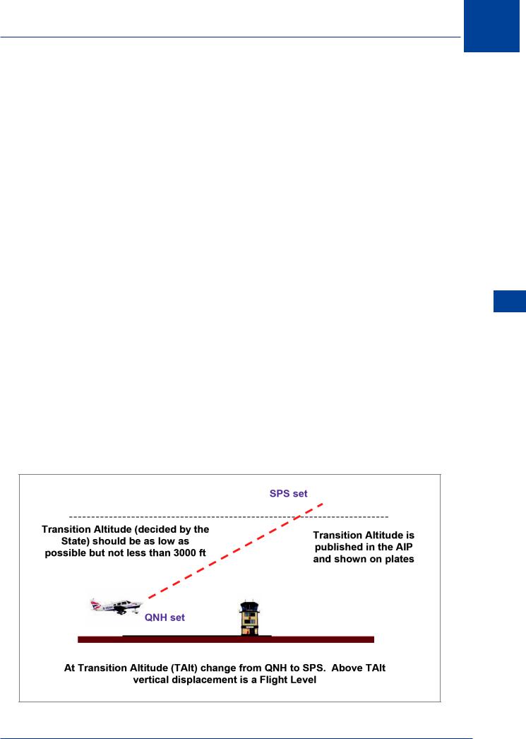
11.10Definition. After take-off, the altimeter setting will be changed from QNH to SPS at some point. Likewise in the descent to land, the altimeter will be set to QNH from SPS at some point. The process that allows this to be done safely and at a logical point is called transition. This requires the altitude (or FL) at which this is done to be specified. The altitude above the aerodrome for change from QNH to SPS is called the transition altitude, and from SPS to QNH is the transition level. When flying below the transition altitude, the aircraft is flown at altitudes determined with reference to sea level pressure (QNH) and the vertical position is expressed in terms of altitude. Above the transition altitude, the vertical position is expressed in terms of flight levels. During a climb upon reaching the transition altitude, SPS is set and the climb continued to the desired flight level. In the descent, upon reaching the transition level, the QNH is then set and descent continued to the desired altitude. An exception to the above is when, on descent, the pilot is passed the QNH whilst still above the transition level in which case the pilot would refer to vertical position as an altitude.
11.11Flight Levels. A flight level (FL) is defined as the vertical displacement of the aircraft above a constant level of barometric pressure related to 1013 hPa. Flight Level Zero (FL0) is located at the atmospheric pressure level of 1013 hPa. Subsequent flight levels are separated by a pressure interval corresponding to 500 ft in standard atmosphere. Flight levels are numbered as follows:
FL30; FL35; FL40; FL45 etc…. and FL100; FL105; FL110 etc….
11.12 Transition Altitude. This is the altitude (with QNH set) above the aerodrome at which the altimeter subscale is reset to SPS and vertical position above that is then reported as a flight level. The transition altitude is specified for every aerodrome by the Authority of the State in which the aerodrome is located. The transition altitude shall be as low as possible but normally not less than 3000 ft. Transition altitudes are published in the AIP and shown on charts and instrument plates. A state may specify a general transition altitude (as in the USA, 18 000 ft).
Figure 11.2 Transition altitude
11
Altimeter Setting Procedure 11
223
11 Altimeter Setting Procedure
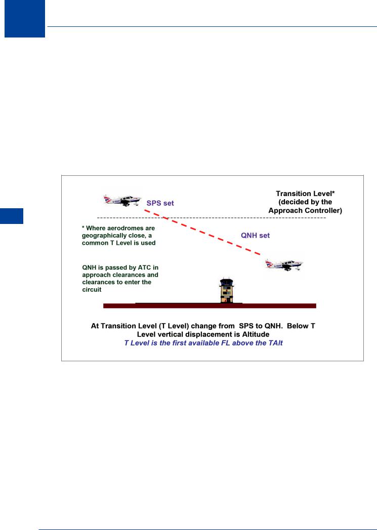
11.13 Transition Level. The transition level is the flight level at which the altimeter is reset to the aerodrome QNH and subsequent flight is reported with reference to altitude. The transition level changes with the QNH. It is calculated by the Approach Controller at regular intervals and also when QNH changes. It is defined as the first available flight level above the transition altitude. This will be a ‘rounding up’ from what the altimeter is reading at the transition level with SPS set. Calculation of transition level is not required by the learning objectives.
The flight crew shall be provided with the transition level :
a.prior to reaching the level during the descent
b.in the approach clearance
c.when requested by the pilot
Procedure Setting Altimeter 11
Figure 11.3 Transition level
11.14 Transition Layer. This is the airspace between the transition altitude with SPS set and the transition level. It is usually insignificant but some states require a minimum depth to the transition layer. When ascending through the transition layer (with SPS set) vertical position is reported as a flight level and when descending through the layer with QNH set, as an altitude.
224
Altimeter Setting Procedure 11
Figure 11.4 Transition layer
Phases of Flight
11.15What Should be Set? The QNH should be passed to an aircraft in the taxi clearance prior to take-off. When flying en route below the transition altitude, the vertical position of the aircraft is reported as altitude (QNH set). When outside of the ‘vicinity’ of the departure aerodrome, QNH from another (closer) aerodrome will be required and set. In the UK we have a system of regional pressure settings (RPS) which cover this case without reference to en route aerodrome QNH. In the USA when flying cross-country, the pilot will need to contact ATC at ‘local’ aerodromes and update the altimeter setting regularly. This will allow determination of terrain clearance with an acceptable degree of accuracy. When en route and above the transition altitude, the aircraft level is reported as a flight level. When approaching an aerodrome to land, the QNH will be passed to aircraft in clearances to enter the traffic circuit. Normally, vertical position is reported as a flight level until reaching the transition level in the descent, however, after an approach clearance has been issued, reference should then be made in terms of altitude with the QNH set. This is intended to apply primarily to turbine aircraft for which an uninterrupted descent from high altitude is desirable.
11.16Use of QFE. If a pilot decides to remain in the aerodrome traffic circuit (the visual circuit) throughout the flight, then the altimeter may be set to QFE.
Altimeter Setting Procedure 11
225

11 Altimeter Setting Procedure
Procedure Setting Altimeter 11
11.17 Pilot/Operator Procedures. Pilots and operators are required to plan the route and, complying with the rules of a state and the general flight rules, are to select an appropriate IFR or VFR flight level for the flight. In selecting flight levels for a flight, those selected:
•Should ensure adequate terrain clearance at all points along the route;
•Should satisfy ATC requirements and
•Should be compatible with the table of cruising levels in Chap. 6
The serviceability and accuracy of the altimeter should be confirmed prior to the commencement of a flight. With knowledge of the aerodrome elevation in the case of QNH, the altimeter should be set to either QNH or QFE. The instrument should then be vibrated (avoiding tapping the glass) to ensure that the instrument has reacted to the mechanical adjustment of setting the subscale. A serviceable altimeter will indicate:
•The height of the altimeter above the reference point (QFE) or
•The elevation of the position of the aeroplane plus the height of the altimeter above the ground (QNH);
11.18 Altimeter Accuracy. Altimeters are to be checked for correct operation within the following tolerances:
•Plus or minus 60 ft (20 m) for a test range between 0 - 30 000 ft or
•Plus or minus 80 ft (28 m) for a test range between 0 - 50 000 ft
11.19Approach and Landing. Before commencing an approach to an aerodrome, the pilot is to obtain the transition level. Before descending below the transition level, the latest QNH for the aerodrome is to be obtained. (This does not preclude a pilot using QFE for terrain clearance purposes during the final approach to a runway.) ATC may clear an aircraft to be operated using QNH when above the transition level if so required for the purpose of descent in accordance with a prescribed procedure (i.e. not for level flight). When an aircraft which has been given clearance as number one to land is using QFE to complete the approach, OCH is to be established with reference to height above the aerodrome datum for that portion of the flight. On approach plates all vertical displacement is shown as both AMSL and AGL in the following form: 2000 (1485) with the AMSL figure in bold type and the AGL figure in parenthesis. This is a standard format and is used in all publications.
11.20Minimum Flight Altitudes. Minimum flight altitudes are determined and promulgated by the State for each ATS route and Control Area (CTA) over its territory. They are published in the national Aeronautical Information Publication (AIP).
226