GIS For Dummies
.pdfChapter 22: Ten Questions to Ask Potential Vendors 331
What Hardware Expertise Do You Have?
Your computer and its operating system are the lifeblood of your GIS. Additionally, you need peripherals such as monitors, input devices, plotters, printers, and even components such as storage and memory. A vendor that has expertise in finding solutions for a wide variety of hardware configurations provides yet another level of security and reliability for your GIS operations.
Ask the potential vendor for specific services and expertise regarding different platforms, operating systems, and peripherals under differing implementation circumstances. If, for example, you need to use your GIS in hazardous environments, you might ask about what hardened equipment (equipment that can withstand rough treatment encountered in field or even battlefield conditions) you might need.
What Does the Price Include?
You absolutely need to know exactly what you get from the vendor for the price you pay. If, for example, the vendor fails to include all the GIS parts and services when bidding the job, who’s going to pay for any cost overruns that may occur? Does the price include hardware, software, installation, database development, upgrades, technical support, or other services?
How Long Until the System
Is Operational?
If your tasks are time-critical, be very specific about when you need final delivery of the product. More importantly, perhaps, you want to know when the system will be fully implemented and operational. Just because the hardware and software are in place doesn’t mean that you’re ready to use them. You may need to go through training and data conversion, or even module creation and testing, which require additional time. Ask for a schedule of progress reports, as well as some formal agreed-upon procedures if the vendor doesn’t complete the project on time.


Chapter 23
Ten GIS Data Sources
In This Chapter
Getting data from government sources
Exploring clearinghouses
Finding commercial sources
The driving force behind all GIS analysis is data. GIS data come in many forms, from many sources, for many uses, with many scales and levels of
accuracy, in different datums and projections, and at a huge variety of prices. Depending on your application and your specific needs, you may want to develop your own datasets. Developing your own datasets allows you to have total control over the content and accuracy, not to mention the ownership, of your data. Industry experts have claimed that data conversion (creating digital databases) often accounted for as much as 60 percent of the cost of system development. Large operations faced an enormous cost. Although these percentages have decreased over the years, they are still a substantial portion of the cost of operating a GIS. And so you might want to examine the possibility of obtaining datasets that already exist.
The sections in this chapter give you an overview of some handy GIS data sources, and Table 23-1 outlines their important features. While you’re evaluating sources, here are some questions that you can ask yourself to help you determine which tool you want to use:
Does your GIS have metadata management tools?
Do you need a tool that supports content standards (specifically the Content Standard for Digital Geospatial Metadata, or CSDGM)?
Do you need document data resource beyond what your GIS does?
Do you need a distributable tool for your partners?
What features are most important to you? For example, you may consider auto-capture of information, bundling metadata with data, creation and use of templates, user interface, or robust help menus and tutorials important features.

334 Part VI: The Part of Tens
Table 23-1 |
Features of GIS Data Sources |
|
||
Data Source |
Type / Format |
Data origin / |
Access / |
Coverage |
|
|
Compliance |
Price |
|
GIS Data |
General |
Original |
Download |
Worldwide |
Depot |
Various themes |
datasets (for |
from user |
|
|
and scales / |
example, U.S. |
account / |
|
|
Industry- |
Geological |
Free or |
|
|
standard |
Survey) and |
priced per |
|
|
formats |
value-added |
data block / |
|
|
|
translations / |
Data on |
|
|
|
SDTS* |
CD-ROM at |
|
|
|
compliant |
a fee |
|
Environ- |
General |
Government |
Direct |
Worldwide |
mental |
Various themes |
and commer- |
download |
|
Systems |
and scales / |
cial providers |
or on DVD / |
|
Research |
Shapefiles, |
compiled |
free, |
|
Institute (ESRI) |
export files, |
in-house / |
free with |
|
|
ArcGIS |
FGDC**/SDTS |
software |
|
|
compatible, |
compliant; |
purchase, |
|
|
and image data |
metadata |
or separate |
|
|
|
conform to |
purchase |
|
|
|
ISO*** 19115 |
|
|
National |
General |
Government |
Online |
United |
Geospatial |
Various themes |
and some |
search and |
States |
Data Clearing- |
and scales / |
third-party / |
download / |
|
house |
Typical image, |
SDTS |
free or at |
|
|
export, and |
compliant |
cost |
|
|
shapefiles |
|
|
|
Center for |
General to |
Government, |
Online |
Worldwide |
International |
specific |
commercial, |
search and |
|
Earth Science |
Various themes |
and academic |
download / |
|
Information |
and scales / |
providers, |
free or |
|
Network |
ESRI shape- |
as well as |
restricted |
|
(CIESIN) |
files, grid data, |
value-added |
for specific |
|
|
and other |
products / |
datasets; |
|
|
industry- |
SDTS |
policy doc- |
|
|
standard |
compliant |
uments and |
|
|
formats |
|
metadata |
|
|
|
|
catalog |
|
|
|
|
search also |
|
|
|
|
online |
|


336 Part VI: The Part of Tens
Table 23-1 (continued)
Data Source |
Type / Format |
Data origin / |
Access / |
Coverage |
|
|
Compliance |
Price |
|
Geoscience |
Geodetic, |
Government- |
Online |
Australia |
Australia |
topographic, |
generated |
search and |
|
|
thematic data- |
datasets / |
download / |
|
|
sets / ArcInfo, |
Compliant |
Free with |
|
|
ArcView and |
with |
registration |
|
|
MapInfo |
Australian |
or at cost |
|
|
|
standards |
for optical |
|
|
|
organization |
formats |
|
|
|
|
|
|
Canada |
General to |
U.S. and |
Online |
Canada |
Geospatial |
specific Atlas |
Canadian |
search and |
|
Data Infra- |
and land-use |
government |
download / |
|
structure |
Various themes |
agencies / |
Free |
|
|
and scales / |
SDTS |
|
|
|
Raster and |
compliant |
|
|
|
vector datasets |
|
|
|
|
with separate |
|
|
|
|
metadata files |
|
|
|
|
(XML and |
|
|
|
|
HTML) |
|
|
|
*SDTS: Spatial Data Transfer Standard **FGDC: Federal Geographic Data Committee
***ISO: International Standards Organization
++CGIAR: Consultative Group on International Agricultural Research
Whichever tool you choose, remember that metadata are essential for maintaining your own databases and obtaining compatible data from external sources.
GIS Data Depot
GIS Data Depot (http://data.geocomm.com) provides free spatial data, as well as spatial data that you can purchase. The Web site makes it clear right from the start that you need to be proficient in GIS and have access to GIS software. You can download datasets, or for a charge, the data provider can produce datasets as CD-ROM media.
In addition to data, GIS Data Depot also provides an array of utilities, translators, viewers, and scripts to assist you in your purchase and subsequent use of the data.

Chapter 23: Ten GIS Data Sources 337
Contact Info: MindSites Group, LLC, 1161 John Sims Pkwy. E., Niceville, FL 32578. Phone: 850-897-1002. Fax: 850-897-1001. Web: http://data. geocomm.com (you can find an e-mail form on the Web site).
Environmental Systems
Research Institute
Environmental Systems Research Institute (ESRI), besides being a huge player in the GIS software and consulting industry, also provides a wide array of spatial data for use with its many products. ESRI provides the data on DVDs that include HTML help systems that have information about redistribution and a complete set of metadata. ESRI also has an ArcGIS Online Content Sharing Program to allow organizations to share spatial data.
ESRI provides its own ArcGIS data appliance with pre-rendered U.S. and worldwide data residing on its own ArcGIS Server. These data appliances are already optimized for publishing with ArcGIS Server and include imagery, street maps, shaded relief, and elevation data. You can add your own data to this pre-formatted server to reduce computation time and optimize workflow.
Contact Info: Environmental Systems Research Institute, 380 New York St., Redlands, CA 92373-8100. Phone: 909-793-2853. Fax: 909-793-7070. Web: www. esri.com (access the e-mail form on the Web site).
National Geospatial Data Clearinghouse
A direct outcome of the United States’ Federal Geographic Data Committee’s (FGDC) collaborative activity was the establishment of a group of about
250 cooperating government bodies in the United States called the National Geospatial Data Clearinghouse (NGDC). Organizations must apply for membership in the network and satisfy the FGDC standards to belong. The EROS Data Center (a USGS-run geospatial data facility) and the FGDC host the clearinghouse data.
The NGDC provides well-organized and complete metadata. You can easily access that metadata — but NGDC doesn’t commonly offer additional tools.
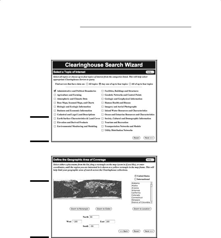
You can choose from several user interfaces to search for data to download. One really nice feature of this interface is the search wizard that allows you to search for geospatial data by category, as shown in Figure 23-1. After you select the category of data that you’re looking for, you can narrow the search by selecting a state from a drop-down menu, graphically choosing an area on the search window, or defining the latitude and longitude extent (see Figure 23-2).

Chapter 23: Ten GIS Data Sources 339
Center for International Earth Science Information Network (CIESIN)
CIESIN, housed and operated by Columbia University’s Earth Institute, provides data, education, support, and research on data integration. Its interests focus primarily on human and environment interactions, which give CIESIN a decidedly more focused perspective on the datasets it provides and on
its mission. The primary goals include examining the human dimensions of global change.
Beyond performing its own research and providing valuable data, CIESIN also specializes in digital archiving, metadata systems, and customer relations management, including usability outreach. It has metadata specialists available to ensure that the metadata are complete and correct.
Contact Info: Center for International Earth Science Information Network (CIESIN), 61 Rte. 9W, P.O. Box 1000, Palisades, NY 10964. Phone: 845-365-8988. Fax: 845-365-8922. E-mail: ciesin.info@ciesin.columbia.edu. Web: www.ciesin.org.
Go-Geo!
Go-Geo! is a United Kingdom (U.K.) geospatial data port that focuses predominantly on the academic community, but also serves many others. Funded by the Joint Information Systems Committee (JISC) and operated by the University of Essex and the University of Edinburgh, Go-Geo! provides an opportunity to discover, locate, and retrieve data that would otherwise be difficult to find. Moreover, this initiative also supports the concept of maintaining high spatialdata standards and quality through metadata development.
Go-Geo! provides a number of helpful resources, including terminology, explanations of data types, and descriptions of data standards. In addition, it links to other resources that you can use to conduct data searches. As a soft-funded project (funded by research grants that may not last), Go-Geo! is a trial database provider and may be temporary.
Contact Info: Contact with Go-Geo! is limited to the Internet: www.gogeo. ac.uk. It does have a log-in function for members of U.K. higher education.