


GPS NAVIGATION
5.14 NEAREST VOR (MFD)
VOR Identifier, Symbol, Bearing, Distance (within 200 nm of current position)
Reference VOR
Name,
Closest City, Type,
Mag Variation,
Position
Selected VOR
Frequency
Figure 5-52 Nearest VOR Page
Selecting a nearest VOR:
1)Select the NRST Page Group.
2)Select the fourth rectangular page icon, the Nearest VOR Page.
3)Press the FMS Knob to activate the cursor.
4)Turn the FMS Knob to select the desired nearest VOR.
OR:
1)Press the VOR Softkey to place the cursor in the ‘NEAREST VOR’ window.
2)Turn the FMS Knob to select a VOR.
3)Press the FMS Knob to remove the flashing cursor.
190-00498-02 Rev.A |
Garmin G1000 Pilot’s Guide for Cessna Nav III |
5-57 |
GPS NAVIGATION
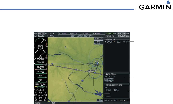
5.15 NEAREST USER WAYPOINT (MFD)
Nearest User
Waypoint
Name, Symbol,
Bearing,
Distance
Nearest User
Waypoint
Information
Reference
Waypoints
Figure 5-53 Nearest User Waypoint Page
The Nearest User Waypoints Page (Figure 5-53) displays a list of up to the 25 nearest user waypoints that are within 200 nm of the aircraft’s present position. Each list item includes the identifier, icon, bearing, and distance totheuserwaypointfromthecurrentposition. Anarrowbeforetheidentifierindicatestheselecteduserwaypoint. Up to eleven user waypoints are visible at a time. If more than eleven are available, a scroll bar is available. If there are no user waypoints in the list, text indicating that there are no nearest user waypoints is displayed.
Information about the selected user waypoint includes the user comment and location (latitude and longitude). Reference waypoints for the selected user waypoint are those specified when the user waypoint was created. If there is only one valid reference waypoint, the bearing and distance from the reference waypoint is stated and the second reference waypoint information is dashed. If there are no user waypoints or no valid reference waypoints, the reference waypoint fields are dashed. If there are two valid reference waypoints, the bearings from the reference waypoints are stated and the first reference waypoint’s distance field is dashed.
A map of the currently selected user waypoint and surrounding data is displayed which at a minimum shows the selected user waypoint and the current aircraft position. A line is drawn between the current position and the selected user waypoint.
Selecting a nearest user waypoint:
1)Select the NRST page group. Select the fifth rectangular page icon, the Nearest User Waypoints Page.
2)With the Nearest User Waypoint Page displayed, press the FMS Knob to activate the cursor. If any previously entered User Waypoints are within 200 nm, these will be displayed with the closest waypoint listed first.
3)Turn the FMS Knob to select the desired waypoint. The remaining information on the Nearest User Waypoint Page pertains to the selected Nearest User Waypoint.
4)Press the FMS Knob to remove the flashing cursor.
5-58 |
Garmin G1000 Pilot’s Guide for Cessna Nav III |
190-00498-02 Rev.A |
GPS NAVIGATION
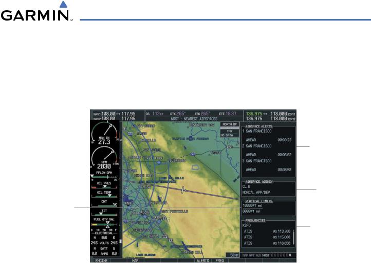
5.16 NEAREST AIRSPACES
The G1000 alerts the pilot to as many as nine controlled or special use airspaces (up to three at one time) near or in the flight path. The airspace name, class, controlling agency, vertical limits, and associated frequencies are displayed for the selected airspace.
Airspace Alerts
Note: At most, three airspace alerts are shown at any given time
Airspace Type
and Controlling The Ceiling and Agency Floor Altitudes
(vertical limits)
Associated Frequencies for the Currently Selected Airspace Alert
Figure 5-54 Nearest Airspaces Page
Selecting and viewing an airspace alert and associated information:
1)Select the Nearest Airspace Page by selecting the NRST Page Group and then select the seventh page in the group.
2)Press the ALERTS Softkey to place the cursor in the ‘AIRSPACE ALERTS’ Box (Figure 5-54).
3)Select the desired airspace.
4)Press the FMS Knob to remove the flashing cursor.
190-00498-02 Rev.A |
Garmin G1000 Pilot’s Guide for Cessna Nav III |
5-59 |

GPS NAVIGATION
OR:
1)With the Nearest Airspace Page displayed, press the MENU Key.
2)Highlight ‘Select Alerts Window’.
3)Press the ENT Key. The cursor is placed in the ‘AIRSPACE ALERTS’ Box.
4)Select the desired airspace.
5)Press the FMS Knob to remove the flashing cursor.
OR:
1)With the Nearest Airspace Page displayed, press the FMS Knob. The cursor is placed in the ‘AIRSPACE ALERTS’ Box.
2)Select the desired airspace.
3)Press the FMS Knob to remove the flashing cursor.
Once an airspace alert has been selected, associated information concerning the specific airspace is provided. The information includes Airspace Name, Status, and Time to Entry. The status and time to entry (if applicable) are based on the following conditions:
•If the projected course will take the aircraft inside an airspace within the next ten minutes, the status field shows the airspace as ‘Ahead’.
•If the aircraft is within 2 nm of an airspace and the current course will take the aircraft inside, the status field shows the airspace as ‘Ahead < 2 nm’.
•If the aircraft is within 2 nm of an airspace and the current course will not take the aircraft inside, the status field shows ‘Within 2 nm’.
•If the aircraft has entered an airspace, the status field shows ‘Inside’.
The airspace alerts are based on three-dimensional data (latitude, longitude, and altitude) to avoid nuisance alerts. The alert boundaries for controlled airspace are also sectored to provide complete information on any nearby airspace. Once the described conditions exists, the status and time of entry is shown if the airspace alert messages are enabled on the System Setup Page (Auxiliary Page Group; see the System Overview Section).
At most three airspace alerts are displayed at any given time. The user can change the airspace alerts that are currently visible. For each airspace alert the name of the airspace, the proximity status (Inside, Ahead < 2 nm, Ahead, Within 2 nm), and the time until the current path of the aircraft will intercept the airspace (only when the airspace is Ahead, or Ahead < 2 nm, otherwise “__:__:__” is used) is displayed. If there are more than three airspace alerts they are displayed in a scrollable list box with only three visible at one time.
All airspace alerts, except for prohibited areas, may be turned on or off from the System Setup Page. An altitude buffer is also provided on the System Setup Page to provide an extra margin of safety above or below the published limits. See the System Overview Section for additional details.
5-60 |
Garmin G1000 Pilot’s Guide for Cessna Nav III |
190-00498-02 Rev.A |
GPS NAVIGATION
The following types of airspaces (information shown in the Airspace Agency Box, Figure 5-46) are on the Nearest Airspaces Page:
•ICAO control area
•Mode C tower area
•Alert area
•Caution area
•Danger area
•Prohibited area
•Restricted area
•Training area
•Unknown area
•Warning area
•Class C, ICAO terminal control area, Terminal radar service area (TRSA), Mode C area, and Military operations area (MOA)
•Military operations area (MOA), Warning area, Alert area, Caution area, Danger area, Prohibited area, Restricted area, Training area, and Unknown area
•Class B airspaces
•Class C airspaces
•Class D airspaces
•MOA airspaces
The Vertical Limits Box displays the floor and ceiling limits of the airspace alert. The following are examples of what may appear as vertical limits for an airspace:
•5000 ft MSL (5,000 feet mean sea level)
•5000 ft AGL (5,000 feet above ground level)
•MSL (at mean sea level)
•NOTAM (see Notice to Airmen)
•Unknown
•Unlimited
•See Chart
•Surface
190-00498-02 Rev.A |
Garmin G1000 Pilot’s Guide for Cessna Nav III |
5-61 |