

GPS NAVIGATION
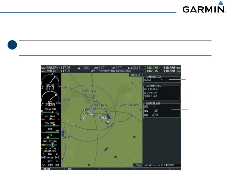
5.7 INTERSECTION INFORMATION (MFD)
 NOTE: The VOR displayed on the Intersection Information Page is the nearest VOR, not necessarily the VOR used to define the intersection.
Intersection
Name and
Symbol
Intersection
Information
Nearest VOR
Figure 5-45 Intersection Information Page
Selecting an intersection:
1)Select the WPT Page Group.
2)Select the second rectangular page icon which is the Intersection Information Page.
3)Press the FMS Knob to activate the cursor.
4)Enter the name of the identifier.
5)Press the ENT Key.
6)Press the FMS Knob to remove the flashing cursor.
5-46 |
Garmin G1000 Pilot’s Guide for Cessna Nav III |
190-00498-02 Rev.A |

GPS NAVIGATION
5.8 NDB INFORMATION (MFD)
NDB Name Symbol,
and Location
General
Location
NDB Frequency
Nearest Airport; identifier, symbol, bearing, distance
Figure 5-46 NDB Information Page
Selecting a specific NDB:
1)Select the WPT Page Group.
2)Select the third rectangular page icon, the NDB Information Page.
3)Press the FMS Knob to activate the cursor.
4)Highlight the desired selection field (identifier, name, or closest city).
5)Enter an identifier, name, or city.
6)Press the ENT Key.
7)Press the FMS Knob to remove the flashing cursor.
AnNDBdesignatedasacompasslocator(LOM)isalowpower,lowormediumfrequencyradiobeaconinstalled in conjunction with the instrument landing system. When LOM is used, the locator is at the Outer Marker; when LMM is used, the locator is at the Middle Marker.
If duplicate identifiers occur, a Duplicate Waypoints Menu pops up, from which the desired waypoint can be selected. When scrolling through the closest cites list to select an NDB, a city may appear more than once, depending on the number of NDBs near it.
190-00498-02 Rev.A |
Garmin G1000 Pilot’s Guide for Cessna Nav III |
5-47 |

GPS NAVIGATION
5.9 VOR INFORMATION (MFD)
VOR Name,
Symbol, and
Location
VOR
Information
VOR Frequency
Nearest Airport; identifier, symbol, bearing, distance
Figure 5-47 VOR Information Page
Selecting a VOR:
1)Select the WPT Page Group.
2)Select the fourth rectangular page icon, the VOR Information Page.
3)Press the FMS Knob to activate the cursor.
4)Highlight the desired selection field (identifier, name, or closest city).
5)Enter an identifier, name, or city.
6)Press the ENT Key.
7)Press the FMS Knob to remove the flashing cursor.
5-48 |
Garmin G1000 Pilot’s Guide for Cessna Nav III |
190-00498-02 Rev.A |

GPS NAVIGATION
5.10 USER WAYPOINT INFORMATION (MFD)
User Waypoint
Name and Symbol
Information
Reference
Waypoints
User Waypoint List
Number of
Waypoint Slots
Used/Avaialble
Figure 5-48 User WPT Information Page
User waypoints may be created from the User Waypoint Information Page or the Navigation Map Page. To create a new user waypoint from the User Waypoint Information Page, enter the name (identifier) and position, or reference another waypoint by radial and distance.
Creating a new user waypoint:
1)Select the WPT Page Group.
2)Select the fifth rectangular page icon.
3)With the User Waypoint Information Page displayed, press the FMS Knob to activate the cursor.
4)Enter a name for the new waypoint.
5)Press the ENT Key. The message ‘Are you sure you want to create the new user waypoint’ is displayed.
6)With ‘YES’ highlighted, press the ENT Key.
7)Highlight the latitude/longitude field or the ReferenceWaypoints field, depending on how the waypoint is to be defined.
8)Enter the position coordinates or the radial and distance from the reference waypoint.
9)Press the ENT Key to accept the new waypoint.
10)Press the FMS Knob to remove the flashing cursor.
190-00498-02 Rev.A |
Garmin G1000 Pilot’s Guide for Cessna Nav III |
5-49 |

GPS NAVIGATION
OR:
1)With the User Waypoint Information Page displayed, press the NEW Softkey to activate the cursor.
2)Enter a name for the new waypoint.
3)Press the ENT Key. The message ‘Are you sure you want to create the new user waypoint’ is displayed.
4)With ‘YES’ highlighted, press the ENT Key.
5)Highlight the latitude/longitude field or the ReferenceWaypoints field, depending on how the waypoint is to be defined.
6)Enter the position coordinates or the radial and distance from the reference waypoint.
7)Press the ENT Key to accept the new waypoint.
8)Press the FMS Knob to remove the flashing cursor.
Creating user waypoints from the Navigation Map Page:
1)With the Navigation Map Page displayed, press the Joystick to activate the panning function. The Map Pointer is displayed at the present aircraft position.
2)After placing the pointer at the desired position,press the ENT Key. The UserWaypoint Information Page is now displayed with the captured position.
3)Enter a waypoint name.
4)Press the ENT Key to accept the selected name. The first reference waypoint field is highlighted.
5)If desired, enter the identifier of the reference waypoint and the radial and distance to the reference waypoint.
6)Press the ENT Key to accept.
7)Press the FMS Knob to remove the flashing cursor.
Modifying a user waypoint:
1)With the User Waypoint Information Page displayed, press the FMS Knob to activate the cursor.
2)Move the cursor to the desired user waypoint in the list at the bottom of the screen.
3)Press the ENT Key to select the desired user waypoint.
4)Use the small FMS Knob to make changes.
5)Press the ENT Key to accept the changes.
6)Press the FMS Knob to remove the flashing cursor.
5-50 |
Garmin G1000 Pilot’s Guide for Cessna Nav III |
190-00498-02 Rev.A |
GPS NAVIGATION
‘Present Position’ when selected will move the currently selected user waypoint to the present position of the aircraft. The user waypoint is set to the airplane’s position at the time when the option was selected.
Moving the currently selected user waypoint to the present position of the aircraft:
1)Select the User Waypoint Information Page and press the MENU Key.
2)Ensure the desired user waypoint is selected.
3)Select ‘Use Present Position’.
4)Press the ENT Key.
5)Highlight the position and press the ENT Key.
‘Auto Comment’, when selected, will overwrite the currently selected user waypoint comment with an automatically generated comment. Auto comments are in the same format as comments that are generated for user waypoints that have no specified user comments. The auto comment can be one of three styles:
•REF1BRG1 / DIS1 - if the user waypoint position is defined by a reference 1 waypoint radial and distance (this is generally the default case, but the comment could be left blank if there are no reference waypoints near the user waypoints position.
•REF1BRG1 / REF2BRG2 - if the user waypoint position is defined by a reference 1 waypoint radial and a reference 2 waypoint radial
•BLANK - if no reference waypoints are near the user waypoints position
Overwriting the currently selected user waypoint’s comment with an automatically generated comment:
1)Select the desired waypoint on the User Waypoint Information Page.
2)Press the MENU Key. Select ‘Auto Comment’.
3)Press the ENT Key.
‘Rename User Waypoint’ renames a user waypoint.
Renaming a user waypoint using the options menu
1)Select the User Waypoint Information Page.
2)Press the MENU Key. Select ‘Rename user Waypoint’.
3)Rename the waypoint. Press the ENT Key.
4)The message ‘Would you like to rename the user waypoint’ is displayed. Select ‘YES’ to rename the new user waypoint.
190-00498-02 Rev.A |
Garmin G1000 Pilot’s Guide for Cessna Nav III |
5-51 |

GPS NAVIGATION
OR:
1)Select the User Waypoint Information Page.
2)Press the RENAME Key. The name field is blank.
3)Enter the new name.
4)Press the ENT Key. A confirmation window is displayed.
5)With ‘YES’ highlighted, press the ENT key.
Deleting a user waypoint:
1)Select the User Waypoint Information Page.
2)Press the MENU key to display the User Waypoint Information Page options.
3)Select ‘Delete User Waypoint’ or press the DELETE Softkey.
4)Press the ENT Key. The message ‘Would you like to delete the user waypoint’ is displayed.
5)With ‘YES’ highlighted, press the ENT key.
Deleting all user waypoints:
1)Select the User Waypoint Information Page.
2)Press the MENU Key.
3)Select ‘Delete All User Waypoints’
4)Press the ENT key. A confirmation windows is displayed.
5)Press the ENT Key to accept ‘YES’ or highlight ‘NO’.
6)Press the ENT Key.
5-52 |
Garmin G1000 Pilot’s Guide for Cessna Nav III |
190-00498-02 Rev.A |