

11 Mapping Agricultural Terraces in Italy. Methodologies Applied … |
191 |
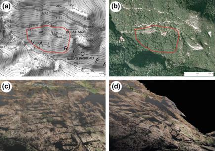
Fig. 11.5 UAV survey and mapping in Rio Freddo Valley, (Prealps of Vicenza Province) in the area bounded in red. In a, it is to note the 1:10,000 map edited in 1997, and so in the orthophotos of the year 2007 (b) a “cartographic desertification” of the abandoned, but still persisting, anthropic terraces. In c and d, a 3D drape of drone photos over the drone photogrammetric DTM. These terraces were cultivated with beans, potatoes, and corn until about 1960
11.4Conclusion
The MAPTER project tested different methodologies and approaches to map and to extract different typologies of terraced systems widely distributed along the Italian territory. Terraced systems are extremely heterogeneous in relation to their physical conservation status, morphology, natural vegetation. They are shaped by the climate (arid or semi-arid in south and center of Italy, versus a continental climate in north Italy) and/or by the morphology of flank slope (inclination, bedrock, soil). By collecting and processing all the geospatial data we estimated, in Italy, a total surface of agricultural terraced systems of about 169,127 ha, and a total length of dry-stone walls of about 180,000 linear kilometers.
Mapping survey at a regional scale with the presence of vegetation canopy, LiDAR technology seems to give the most performance in terms of terrace risers features extraction; however, management of such big geospatial data requires suitable hardware/software resources and it may be time-consuming. Moreover, LiDAR data may be affected by technical problems, such as striping, during to the flight acquisition phase or to the elaboration techniques during the DTM production. According to recent DTM LiDAR analysis, two of the three regions with wider
192 |
F. Ferrarese et al. |
terraced systems (42,636 ha in Liguria and 22,730 ha in Toscana) appear to be underestimated by the traditional survey. Sicily Region, according to the MAPTER comparative analyses, seems to have the widest extension showing 63,554 ha of terraced systems (Barbera et al. 2010), even if an integrated analysis, at very large scale, combining LiDAR data with high-resolution satellite images showed a different extension in the study case of the Filicudi Island in the Aeolian Archipelagos of Sicily (Terranova 2016).
Considering that LiDAR data are becoming widely accessible, in the next years we could continue and maybe complete the LiDAR features extraction of terrace risers. The coastal landscape, for example, where there are some of the widest terraced systems, it is completely surveyed by LiDAR topography, but DTMs were interpolated for 2 m cell size, which are not very suitable for very narrow terrace steps (less than 5 m). Moreover, for some areas the use of UAV survey could provide high-resolution DTMs and pictures, useful data to monitor the state of terrace risers and the risk of landslide. At the same time, the development of lightweight LiDAR suitable for UAV systems can improve the availability of data in densely vegetated landscapes.
Geographic information supplied by Web Map Services and Geobrowsers has opportunities to be improved by participatory approaches, voluntary geography crowdsourcing of georeferenced information. The UAV survey of Rio Freddo Valley was planned after information collected by hikers of the valley. Involvement of hikers, trekkers, and local people shows a possible huge development in mapping terraced systems.
However, mapping terraced system showed some limitations in geospatial data management due to the high degree of complexity and variety of the Italian terraced systems. Hence, an exhaustive geographical survey, integrating different methodologies and techniques, should be implemented to carry out a more detailed map of terraced systems in Italy.
Acknowledgements The MAPTER project was realized thanks to the contribution of many universities, research institutes, public institutions, organizations, and individuals. We wish to thanks G. Brancucci (University of Genova), L. Bonardi, R. Madoi (University of Milan), G. Mauro, A. Giadrossi (University of Trieste), F. Lucchesi, C. A. Garzonio (University of Florence), E. Bonari, D. Rizzo (Scuola Superiore Sant’Anna—Pisa), A. Riggio, S. Modugno (University of Cassino and Southern Lazio), L. Fusco Girard, A. Gravagnuolo, M. Ronza (University of Naples Federico II), S. Di Fazio, G. Modica, S. Praticò (University of Reggio Calabria), G. Barbera, S. Cullotta (University of Palermo), G. Sistu, A. Pirinu (University of Cagliari), G. Tecilla, A. Cosner, G. Altieri (Autonomous Province of Trento), F. Alberti, U. Trivelloni (Veneto Region), M. Baldo, P. Giostrella, D. Giordan, D. Godone (CNR-Irpi, Turin), S. Costetti, D. Genovese, F. Laganà, E. Micati, M. Micheletti, T. Saggiorato (Italian Alpine Club).
Moreover, we are grateful to the “Ministero dell’Ambiente e della Tutela del Territorio e delle Acque, Geoportale Nazionale” for the availability of LiDAR data of many areas of the Italian coasts and islands and to the Department of “Regione Veneto, Ambiente e Territorio” for the regional LiDAR data.
11 Mapping Agricultural Terraces in Italy. Methodologies Applied … |
193 |
References
Agnoletti M, Conti L, Frezza L, Monti M, Santoro A (2015) Features analysis of dry stone walls of Tuscany (Italy). Sustainability 7:13887–13903
Barbera G, Cullotta S, Rossi-Doria I, Rühl J, Rossi-Doria B (2010) I paesaggi a terrazze in Sicilia: metodologie per l’analisi, la tutela e la valorizzazione. In: Collana studi e ricerche dell’Arpa Sicilia, vol 7. ARPA Sicilia, Agenzia Regionale Protezione Ambiente
Bonardi L, Varotto M (2016) Paesaggi terrazzati d’Italia. Eredità storiche e nuove prospettive. Franco Angeli
Brancucci G, Masetti M (2008) I sistemi terrazzati: un patrimonio, un rischio. In: Scaramellini G, Varotto M (eds) Paesaggi terrazzati dell’arco alpino. Atlante. Marsilio, Venezia, pp 46–54 Brancucci G, Paliaga G (2006) The hazard assessment in a terraced landscape: the Liguria (Italy)
study case in Interreg III Alpter project. In: ECI conference on geohazards, Lillehammer, Norway
Brandolini P (2010) I versanti delle Cinque Terre: un patrimonio ambientale e paesaggistico a rischio. Sopra il livello del mare. La Rivista dell’Ente Italiano della Montagna. Numero speciale: il paesaggio costruito. Salvaguardia e valorizzazione dei terrazzamenti artificiali 36:54–56
Brandolini P, Faccini F, Pescetto C (2008) I paesaggi terrazzati d’Italia. I Terrazzamenti della Liguria: un bene culturale e del paesaggio a rischio. L’Universo 88(2):206–221
Brugnaro S (2016) Estrazione mediante approccio Semi Automatico da dati LiDAR, per la quantificazione dei terrazzamenti agricoli: il caso di Amalfi. Unpublished thesis of the ‘II level Master in GISscience and Unmanned Aerial Vehicle’, University of Padova
Gravagnuolo A, Di Martino F (2015) GIS tools for mapping and classification of agricultural areas at risk of abandonment in terraced cultural landscapes. In: Sessa S, Di Martino F, Cardone B (eds) GIS DAY 2015. Il GIS per il governo e la gestione del territorio. Aracne Editrice, Roma Hengl T, Reuter HI (eds) (2009) Geomorphometry: concepts, software, applications. In:
Developments in soil science, vol 33. Elsevier
ISPRA (Istituto Superiore Per la Ricerca Ambientale) (2013) Linee guida per la valutazione del dissesto ecologico e la sua mitigazione attraverso misure e interventi in campo agricolo e forestale. Manuali e linee guida, 85. Ministero dell’Ambiente e della tutela del territorio e del mare, Ministero delle politiche agricole, alimentari e forestali
Jasiewicz J, Zwoliński Z, Mitasova H, Hengl T (eds) (2015) Geomorphometry for geosciences. Adam Mickiewicz University in Poznań—Institute of Geoecology and Geoinformation, International Society for Geomorphometry, Poznań
Lillesand T, Kiefer RW, Chipman J (2015) Remote sensing and image interpretation, 7th edn. Wiley
Minar J, Evans IS (2008) Elementary forms for land surface segmentation: the theoretical basis of terrain analysis and geomorphological mapping. Geomorphology 95:236–259
Modica G, Merlino A, Solano F, Mercurio R (2015) An index for the assessment of degraded mediterranean forest ecosystems. For Syst 24:2171–9845
Ninfo A (2008) Valutazione della pericolosità in aree terrazzate nel Canale di Brenta: un approccio su base LiDAR. In: Fontanari E, Patassini D (eds) Paesaggi terrazzati dell’arco alpino. Esperienze di Progetto. Marsilio, Venezia, pp 28–30
Ore G, Bruins HJ (2012) Design features of ancient agriculture terrace walls in the Negev Desert: human-made geodiversity. Land Degrad Dev 23:409–418
Passalacqua P, Tarolli P, Foufoula-Georgiou E (2010) Testing space-scale methodologies for automatic geomorphic feature extraction from lidar in a complex mountainous landscape. Water Resour Res 46:W11535
Rizzo D, Galli M, Sabbatini T, Bonari E (2007) Terraced landscapes characterization. Developing a methodology to map and analyze the agricultural management impacts (Monte Pisano, Italy). Rev Int Géomat 17:431–447
194 |
F. Ferrarese et al. |
Ronza M (2006) Versanti terrazzati tra tufi e calcari: valenze ambientali, destinazioni agronomiche, scale di osservazione. Geotema 29:83–99. Patròn Editore, Bologna
Rühl J, Pasta S, La Mantia T (2005) Metodologia per lo studio delle successioni secondarie in ex-coltivi terrazzati: il caso di studio di Pantelleria (Canale di Sicilia). Forest@ 2(4):388–398 Sas RJ, Yu JP, Pau CYY, Styles KA (2012) Detection of old agricultural terraces in steep, vegetated terrain using airborne LiDAR: case study from Hong Kong. In: Proceedings of the 33rd Asian conference of remote sensing, vol I, Pattaya, Thailand, 26–30 Nov 2012,
pp 408–417
Sofia G, Marinello F, Tarolli P (2014) A new landscape metric for the identification of terraced sites: the Slope Local Length of Auto-Correlation (SLLAC). ISPRS J Photogram Remote Sens 96:123–133
Tarolli P, Sofia G, Calligaro S, Prosdocimi M, Preti F, Dalla Fontana G (2015) Vineyards in terraced landscapes: new opportunities from LiDAR data. Land Degrad Dev 26:92–102 Terranova L (2016) Estrazione e valutazione dei terrazzamenti agricoli nel contesto eoliano: il caso
di Filicudi. Unpublished thesis of the ‘II level Master in GISscience and Unmanned Aerial Vehicle’, University of Padova
Tres M, Zatta E (2006) Paesaggi terrazzati nel Canale di Brenta. Unpublished dissertation thesis in Landscape Planning, IUAV—University of Architecture of Venice
Varotto M (2004) Geografie dell’abbandono. Valstagna e la fine della civiltà del tabacco. In: Perco D, Varotto M (eds) Uomini e paesaggi del Canale di Brenta. Cierre Edizioni, Sommacampagna (VR), pp 213–226
Varotto M, Ferrarese F (2008) Mapping and geographical classification of terraced landscapes: problems and proposals. In: Scaramellini G, Varotto M (eds) Terraced landscapes of the Alps. Atlas. Marsilio, Venezia, pp 38–45

Chapter 12
Terraced Landscapes: Land
Abandonment, Soil Degradation,
and Suitable Management
Paolo Tarolli, Davide Rizzo and Gerardo Brancucci
Abstract Agricultural terraces are among the most visible and extensive human signatures on different landscapes of the world. Terraces are generally built to retain soil and water, to reduce erosion, and to support irrigation. They reduce slope gradient and length, and facilitate the infiltration of water in areas with a moderate to low soil permeability by controlling the overland flow velocity. Thereby, they create positive effects on agricultural activities. Since ancient times, agricultural terraces have been built in different topographic conditions (e.g. coastal area, hilly, and steep slope mountain landscapes) and used for the cultivation of various crops (e.g. vineyards, fruit and olive groves, cereals, tea). Their management however arises relevant critical issues. Historical terraces are often of the bench type with stone walls and require adequate maintenance. Poorly designed and controlled terraces can lead to slope failures, often due to walls collapsing, increasing potential soil water erosion. Also, terraced areas are often served by agricultural roads that can profoundly influence surface hydrologic processes and erosion. Land abandonment and ageing of the local population, which affected several regions of the world during the last decades, are among the main reasons for the poor maintenance of terraced landscapes. As a consequence, a progressive increase of land degradation and loss of soil functions (e.g. food production, environmental interaction such as water storage, filtering and transformation, biological habitat, physical and cultural heritage) is observed. The purpose of this chapter is to highlight the main critical issues of terraced landscapes, providing a few case studies, and a possible solution for proper long-term management.
P. Tarolli (&)
Department of Land, Environment, Agriculture and Forestry, University of Padova, Legnaro (PD), Italy
e-mail: paolo.tarolli@unipd.it
D. Rizzo
UP 2018.C102 INTERACT, UniLaSalle, Beauvais, France
G. Brancucci
Department of Architecture and Design, Polytechnic School,
University of Genova, Genoa, Italy
© Springer Nature Switzerland AG 2019 |
195 |
M. Varotto et al. (eds.), World Terraced Landscapes: History, Environment, Quality of Life, Environmental History 9, https://doi.org/10.1007/978-3-319-96815-5_12