

162 |
J. M. Pérez Sánchez |
10.3The Agricultural Terraces
In Mexico, terraces were implemented by the ancient inhabitants and developed throughout the Mesoamerican area. Agricultural terraces are a technique for conserving water and preventing soil erosion (Donkin 1979; García Cook 1986; Rojas 2001; Pérez and Juan 2016; González 2016). Terraces are part of the intensive rainfed system and are associated with the moisture system, because they collect enough water to maintain the humidity of the farmland (Palerm 2008). This system was important for the development of the great pre-Hispanic cultures of Mexico, with high population densities and urban centers (Palerm and Wolf 1972; Pérez 2006).
Terraces dominate sloping mountainsides. They are constructed with support walls of stone or adobe, protect the soil from erosion, retain rainwater, and allow the accumulation of alluvial soil (Palerm 2008; Doolittle 2004). Also classified as earth embankments, the terraces can combine borders and canals constructed perpendicularly to the mountainside, whose vertical slopes are of stone, lime, tepetate, or blocks of wall (Trautmann 1981; Martínez et al. 1999). The terraces are artificial, staggered or vertical, constructions with walls of different materials, canals to capture water, and a surface to cultivate.
These, however, are not all the characteristics of terraces. They also increase water infiltration into the soil, diminish the volume of runoff downstream, evacuate excess water at “non-erosive velocities,” reduce sediments in the runoff, and refurbish lands for agriculture. The terraces have been adapted to different environments where climate, soil, topography, and stoniness play an important role in their construction and operation (Martínez et al. 1999).
10.4Terrace Distribution
In 1979, R. A. Donkin first documented the distribution of terraced landscapes in the Americas, and particularly in Mexico, based on archeological data, historical sources, the characteristics of pre-Hispanic agriculture, and agricultural implements used by ancient populations. Donkin proposes two types of considerations in the study of terraces: continental–regional and local characteristics. The former includes territorial distribution, climate, and cultural associations; the latter includes the form and construction of the terraces, a social base and purpose, crops, and irrigation. The abandonment of terraces due to environmental and cultural issues must also be considered.
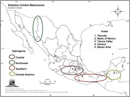
Donkin identifies three regions of agricultural terraces on the American continents: North America, Central America, and South America. In Mexico, he classifies six sub-regions (Fig. 10.1) according to the diversity of environments and the territory’s physiographic characteristics. The different terraced landscape zones in Mexico cover the north, center, and south (Table 10.1).
10 Agricultural Terraces in Mexico |
163 |
Fig. 10.1 Sub-regions and terraced areas in Mexico. Source Donkin (1979)
Although Donkin’s proposal was made about 30 years ago, it is still relevant, and several more recent studies deal with current conditions of the terraces in various areas of Mexico. In Tlaxcala, the studies are of the regions of the volcano Matlalcueye and the Tlaxcala Block (Patrick 1977). In Oaxaca, research focuses on the Mixteca Alta region (Pérez 2006, 2015), and, in the valley of Toluca, on Calixtlahuaca (Smith 2006; Pérez and Juan 2016). Though covering different sites and regions, the studies share the common perspectives of cultural geography, agroecology, cultural ecology, anthropology, history, and archeology.
10.4.1 Terraces in Tlaxcala
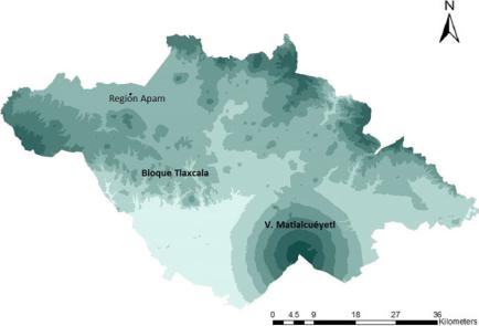
Plains, hills, ravines, and the volcano Matlalcueye characterize the landscape of Tlaxcala (Fig. 10.2). In this region, the problem of soil erosion is not recent. In pre-Hispanic times, the inhabitants knew the problem, and they had, to some extent, controlled it by modifying the surface with terraces (Cook 1986). Archeological studies show that pre-Hispanic populations had already modified the slopes of hills by 1500 BC, as the settlers in the Xochitécatl area did by building terraces on the slopes to construct their houses and cultivate the soil (Cook 1986; Heine 1975). In the Tlaxcala Block region, the construction of the pre-Hispanic terraces allowed the

164 |
|
|
|
|
J. M. Pérez Sánchez |
Table 10.1 |
Regionalization of agricultural terraces in Mexico |
||||
|
|
|
|
||
Region |
|
Sub-region |
Area |
||
A. North |
|
I. Central |
1. |
Basin of Mexico (east and south) |
|
America |
|
Mexico |
2. |
The valley of Teotihuacan |
|
|
|
|
3. |
The valley of the Rio Tula |
|
|
|
|
4. |
Basin of Toluca |
|
|
|
|
5. South of the Piedmont of the Mesa Central: Tenancingo, |
||
|
|
|
Coatepec, Tepoztlan, Ozumba-Chimalhuacan, San Miguel |
||
|
|
|
Atlauta, Tochimilco-Atlixco |
||
|
|
II. East Central |
6. |
The basin of Puebla-Tlaxcala |
|
|
|
Mexico |
7. |
East of the Piedmont of the Mesa Central |
|
|
|
III. West |
8. |
The Western Highlands and the basin of the |
|
|
|
Central |
Balsas-Tepalcatepec |
||
|
|
Mexico |
9. |
The basin of Lake Patzcuaro |
|
|
|
|
10. |
The valley of the Rio Chilchota |
|
|
|
IV. Northwest |
11. |
Southwest Chihuahua and northern Sinaloa |
|
|
|
Mexico |
12. |
Northwest Sonora and north Chihuahua |
|
B. Central |
|
V. Southern |
13. The Mixteca Alta and the basin of Tehuacan: northern, |
||
America |
|
Mexico |
western, southern, and eastern Mixteca Alta |
||
|
|
|
14. |
The Barranca Grande: basin of Tehuacan |
|
|
|
|
15. |
Oaxaca: the valley of Oaxaca-Tlacolula |
|
|
|
|
16. |
The Highlands of Oaxaca |
|
|
|
|
17. |
Chiapas: Chamula-Saklamanton, Amatenango— |
|
|
|
|
Aguacatenango, Comitan—San Francisco, Ocosingo |
||
|
|
VI. Central |
18. |
The Mayan lowlands |
|
|
|
America |
|
|
|
Source Donkin (1979) |
|
|
|
||
inhabitants to identify and use hard soils (tepetate) as a base to build both houses and canals to deflect water (González 2016).
In Tlaxcala, there are two types of farming systems: the terraces and metepantles.1 The latter is a local term used to name a specific type of terraces commonly found on slopes, hills, and canyons. Instead of having a rock wall, metepantles have walls of earth with agave plants. In the Tlaxcala Block, terraces have two distinctive features: retaining walls and ditches. The walls are defensive and anti-erosive elements; they vary in size depending on the slope of the land and cultivated area (Patrick 1977; Bilbao 1979; Mountjoy 1985; Pérez 2014; González 2016). The ditches are parallelepiped-shaped, from 0.40 to 1 m deep, with a length of 1–35 or 40 m (Bilbao 1979). The ditches capture water, sediment, and organic matter, and they are constructed according to the land’s slope and the type of soil (Bilbao 1979; Pérez 2014; González 2016).
1A term derived from the Náhuatl word mepancle: row of agaves that separate land. Me-pantli of metl: maguey [agave], and pancli, pantle, or pancle: board, row, wall. Metepantle is the name given to the set of things put in rows: plants, trees, or agave (Diccionario del Náhuatl 2007).
10 Agricultural Terraces in Mexico |
165 |
Fig. 10.2 Map of Tlaxcala, Mexico
In metepantles, ditches are subdivided into stages following the slope of the land. In the rainy season, the slope of the ditch lets water pass to the next level, capturing rainwater, mud, other plants, and insects, which, while decaying, form organic matter that the farmers deposit on the surface as fertilizer (Bilbao 1979; Pérez 2014; González 2016). The ditches are in three places: (1) along the roads,
(2) along the edges of the farmland, and (3) at the base of the retaining walls in order to catch rainwater or divert excess water toward the canyons (Pérez 2014; González 2016).
Patrick (1977) describes the metepantles system around the Matlalcueye volcano, explaining its retaining walls and row of plants, the gradient and width of the surface, the size of the slope, and the characteristics of the maguey (Agave sp.) plant (its size and the space between plants). In the metepantles terracing technique, planting area, board retention, and the row of agave are fundamental for the development of agricultural practices.
In the municipality of Ixtacuixtla, Pérez (2014) describes the metepantles system in the town of La Caridad Cuaxonacayo—a system which is associated with water deposits and characterized by its cultivation surfaces, vegetation, and containing levees, canals, or ditches. The metepantles contain walls or embankments with different types of vegetation—agave, prickly pear (Opuntia sp.), or fruit trees (pear, apple, plum)—that support the wall (Fig. 10.3). Reservoirs collect rainwater, and a network of water canals provides moisture to crops in the dry season and diverts excess water from the metepantle when necessary.