


124 |
L. Camara and M. B. de Mesquita |
not exceed 1000 inhabitants, the population decrease puts the survival of the municipalities at risk. The expansion of a modern market on the coast with technically diversified crops and the mining sector are some of the factors of the demographic imbalance that bears the area. This growing uprooting of the rural population is causing a crisis in mountain agriculture and on vast terraced areas. The scarce agricultural production only satisfies the subsistence levels, the population therefore decides to emigrate and chooses the way of no return (Camara 2015).
8.2Methodology
To identify and inventory terraced areas, AgroRural employed a methodology using satellite imagery to differentiate functioning from abandoned terraces via the following indicators: the vegetation color (green), the ground color (reflects the persistence of work), the quantity of shrubby vegetation on the walls, and the presence of irrigation infrastructures. Abandoned platforms evidence erosion problems, and the shrubs become straw-yellow in color. The soil is covered with permanent vegetation—dry, herbaceous plants and sometimes native trees. However, high-resolution images are not available in this satellite interface, and there is limited access to mediumand low-resolution images (Landsat TM and CBERS-2B images, with a resolution of 30 m on average). These conditions do not allow adequate visual interpretation to accurately identify the terracing in the images. However, this limitation was overcome through the generation of a “global mosaic” using only a panchromatic band of the high-resolution camera (HRC) sensor. This camera is one of three cameras on board the CBERS-2B satellite, producing images of a wide, 27-km band with a spatial resolution of 2.7 m. This material offers good resolution and very detailed images, excellent for observing and classifying surface terracing units. In this way, visual interpretation of the areas formerly seen in poor resolution has been completed. The images used belong to the INPE-BRAZIL (Instituto Nacional de Pesquisas Espaciais; National Institute of Space Research).3
Although satellite and cartographic information allows researchers to view and correlate variables that represent conservation, use, or abandonment, the results do not show if seemingly abandoned terraces have truly been abandoned or if they have simply been in a state of rest for a long time. Farmers leave the land to fallow according to different criteria, but it can be assumed that, if the land has been left uncultivated for 20 years, it is likely due to lack of workers. For this reason, it is difficult to establish precisely how many areas are truly abandoned.
Field work in communities of the Cusco, Apurimac, Ayacucho, and Lima regions in 2012, and the results of investigations by the non-governmental organization (NGO) Cusichaca (Kendall 2007) the Autoridad del Agua (Water Authority) (ANA 2010)
3The information referring to AgroRural’s methodology was provided to the author during the research phase. However, this information was not published.

8 Terraced Landscapes in Perù: Terraces and Social Water Management |
125 |
have observed that abandonment rates are much higher than the ratio developed by AgroRural. The AgroRural numbers substantially underestimate the real consistency of terraces due to the difficulty of recognizing those at rest and those covered with vegetation, a problem that could be partially solved by direct detection in the field (Camara 2015).
The possibilities offered by satellite and GIS analysis tools are powerful for linking different variables to understand and catalog the terraced heritage (full or partial conservation status, agricultural use, distribution of terracing, etc.). However, to assess the terraces’ qualitative state, researchers must gain the collaboration and trust of farmers, who can define and identify structures in use and those in a critical situation of abandonment. The way this process relates to other geographical variables has not been sufficiently treated from a qualitative point of view. For cataloging, the agricultural production area’s current conservation state (in use or abandoned) must be determined, and, on the basis of this evaluation, agronomic actions undertaken—inserting added value products into the market, calculating production, etc.
8.3Threats to Terraced Landscapes in Peru
As mentioned in the previous paragraphs, Peru has a long history of terrace construction. The agriculture of the sierra is mountain agriculture, and it is important for the population living there. The agriculture practiced in this area is the absolute protagonist of food quality. It uses traditional techniques and production methods to sustainably exploit and integrate natural resources, such as land, water, pastures, and various types of forage crops. Animal products are also transformed with particular qualitative characteristics because they are suitable for agricultural productions of high nutritional and variegated quality. In these areas, agriculture is often the only opportunity for self-support and, to a lesser extent, for the development of incipient tourist-recreational and artisanal activities (Camara 2015).
Agriculture in the sierra has higher costs and lower profitability. Farming in the mountains means clashing with the limits of land use and shorter vegetative cycles, resulting in higher labor costs due to the slopes that require more complicated use of machinery and higher transport and logistics costs. This is also a consequence of splitting plots into small, agricultural units. The sierra economy is one of small plots, with 85% of farmers having less than 10 ha of land.4 The wide dispersion of these plots limits production efficiency and increases production costs.
On the sierra, there is little entrepreneurship, and small family farms are always at high risk of divestment, especially since these structural “disadvantages” are added to pressures from the consequences human activities have on the natural environment, as mountain areas are particularly vulnerable to climate change and atmospheric phenomena. These territories are increasingly marginalized by
4INEI (2009)
126 |
L. Camara and M. B. de Mesquita |
socio-demographic changes, characterized by rural exodus events and the consequent reduction in agricultural employees. This accelerates the abandonment and degradation of terraced areas, at different levels of intensity.
The following paragraphs will focus on three areas of major importance to both farmers and public policies. Analyzing and identifying the critical aspects of terraced areas—including productive, economic, and social processes within the small communities investigated—reflects the realities happening in larger areas and at the national level.
(a) Climate change
Climate change is one of the most serious threats to sustainable agriculture in the Andes. Climate variables—such as temperature, precipitation, atmospheric pressure, solar radiation, and wind speed—structure and influence ecosystem development. In mountain climates, the increase in altitude is accompanied by a decrease in air temperature and humidity, as well as an increase in wind speed, turbulence, and solar radiation. These climatic factors—related to the altitude, vegetation cover, and topography—produce complex meteorological conditions that are expressed in a series of microclimates, some with only short distances between them. Climate variables are irregular in the Andes, even in years considered “normal”. This has generated various climate scenarios with their own characteristics.
The Andes are particularly vulnerable to increasing temperatures and changes in rainfall seasons, all of which destroy habitats, affect plants’ growth phases, and alter the times for sowing and harvesting—increasing the region’s vulnerability and exposing agricultural production to risk. The trends and forecasts of the IPCC (Intergovernmental Panel on Climate Change) (2007) show that extreme climatic events are adversely affecting the flow and frequency of agricultural production and altering the geographical distribution of animal and plant species. The El Niño phenomenon also causes extreme climatic events on the inter-Andean valleys and in the highlands. The consequences impact the most vulnerable and economically weaker population groups, whose very survival is at risk because they live, above all, by agriculture (IICA 2016).
The increase in temperature and humidity has led to a greater spread of infectious wildlife diseases and has altered the geographical distribution of animal and plant species. Over the past 50 years, pastures have been able to stretch almost 300 m higher, and the potato crop has reached an altitude world record of over 4500 m. Farmers have expanded into higher altitudes in an attempt to tackle climate change, but the mountains’ biodiversity and ecosystems are being compromised. Farmers are growing increasingly concerned as grazing areas are threatening to compete with high altitude farming systems (De Haan 2009; Camara 2015), and the areas for animal species adapted to the coldest climates are reducing. This displacement of production areas is altering the food cultivation patterns, the agricultural calendar (sowing, harvesting, etc.), and human settlements. Farmers in some areas also declare that climate events have become more unpredictable and severe. The rains occur in short cycles, start later than usual, and are more dense but short-lived, which does not allow the soil to adequately absorb moisture but instead

8 Terraced Landscapes in Perù: Terraces and Social Water Management |
127 |
erodes the surface. Climate change, therefore, risks making terrace agriculture impossible in the inter-Andean valleys, and even more marginal plateaus, as has already happened in several communities. These impacts to the Andes Mountain ecosystems are very worrying because of the consequences they have on people who depend on mountain resources. Josse et al. (2009 in Herzog et al. 2012) have estimated that about 40 million people find support in the Andean ecosystems.
Through a civilization process encompassing thousands of years, the Andean peoples have developed subsistence strategies to circumvent risks (Earls 2008)— converting the limits of a harsh landscape, with high variability and climatic instability, into opportunities. This process has included domesticating hundreds of species adapted to the diverse climate, terrain, and altitude. For rural Andean people, the morphological limits and the dispersion of risk are not new concepts. Most of the sierra farmers have always relied on these strategies, sowing “here and there, up there and down” a wide range of genetic products and different varieties of the same crop (Camara 2015). This dispersion of agricultural land and crops in various ecological zones and with different maturation times is a strategy developed to minimize losses caused by climatic phenomena. Irregularities in precipitation, drought, hailstorm intensity, or frost do not occur in a uniform manner or affect all soil in the same way, but rather to varying degrees and in dispersed places. Therefore, some plants resist more and are damaged less.
Diversification is maintained and enriched by farmers not resorting to a fixed plan but instead relying on a program organized locally to dissipate one area’s specific problems. This logic is based on meeting local needs and addressing climate uncertainties as well as labor, capital, land, and other economic factors. This ecological-economic reasoning is evident in the way localities use and manage lands based on social and cultural networks of reciprocity and responsibility within the home and the community as a whole.
(b) The abandonment of the terraces
The spread of terracing throughout the Andean area of Peru is very substantial, but terraces have been considered marginal for intensive agronomic activity in various historical periods and were consequently exposed to degradation and abandonment processes.
Based on observations following a survey of the territory5, it seems possible to trace the complex degradation phenomenon to two large categories of abandonment causes: natural and anthropic. The anthropic factors, which today spur terrace conservation, have recently changed sides, as they can be traced to the European raid and the ensuing socio-economic, political, and cultural transformation that hit the mountain areas and imposed upon them a system of resource exploitation. Additionally, archeological (Kendall 2005), anthropological (Treacy 1994), and geographic studies (Donkin 1979; Denevan 1988) identify abandonment of agricultural terraces with
5Field work was carried out in 2012 in various rural communities: the Chicha-Soras valleys, Andamarca, Laraos, Zurite, and Ollantaytambo.

128 |
L. Camara and M. B. de Mesquita |
changes taking place in rural societies and organization systems. Such studies have determined the decrease in available labor forces, lower crop profitability in the absence of adequate transformation companies, and (in answer to these problems) community strategies for valorizing their local products.
Agronomic studies show abandonment in response to modern technical procedures and alterations in traditional agricultural practices (Masson 1986; Tapia 1996). Mechanizing cultivation operations in mountain areas is difficult and strongly impacts the manpower able (and willing) to work. Land ownership is also gradually reducing and fragmenting, making it difficult to determine economies of scale for introducing mechanized systems, and complex social and economic cultural elements hinder organizing cooperation initiatives (Camara 2015).
Economic literature has extensively discussed the competitive advantages associated with reducing costs of agricultural activities in terraced areas. Gonzáles de Olarte and Trivelli (1999), who carried out economic research in three Peruvian regions, report abandoned terraces in areas where the level of development is inadequate. These areas are mostly characterized by high levels of poverty, lack of productive infrastructure, absence of public and private investments, and serious feeding and nutrition problems.
For Gonzáles de Olarte and Trivelli (1999), terraces do not produce positive economic externality because their very expensive construction and reconstruction is not a strategic way to stimulate rural development. The recovery of terraces is an unattractive investment unless traditional crops are exchanged for others the market demands. For example, compared to potatoes and beans, flowers would have greater export elasticity (Gonzáles de Olarte and Trivelli 1999).
Economically, abandoning terraces would result in the loss of positive effects in food production, biodiversity, the control and balance of slope stability, and hydrogeological risks. In a market economy, recovering pre-Hispanic agricultural terraces would increase the physical and natural capital of agricultural land and water (irrigation systems or rainwater exploitation), which would retain water, reduce erosion, and improve landscapes and microclimates. These changes, taken together, should improve farmers’ productivity, augment their income and, consequently, increase their well-being. It would seem a promising formula, but, according to economic studies, its feasibility depends strongly on the national and regional economic context, the institutional framework of intervention, and the level of local involvement.
The current economic climate is dominated by growth and by a series of reform packages aimed at fiscal management, liberalizing trade and the market, and exporting so-called non-traditional products.6 Because terrace recovery is considered costly, this scenario is attempting to redefine the recovery rules.
6From a technical point of view for international trade, a non-traditional product has an added value in its production process or is sufficiently important to transform its natural essence. In 1992 La Comisión Económica para América Latina y el Caribe (CEPAL) applied criteria and limitations to consider non-traditional products, these should not belong to the energy group, their export may be a new product, the product may appear in the market outside the traditional season, and the export of said product must have some importance for some sector of the country’s economy.
8 Terraced Landscapes in Perù: Terraces and Social Water Management |
129 |
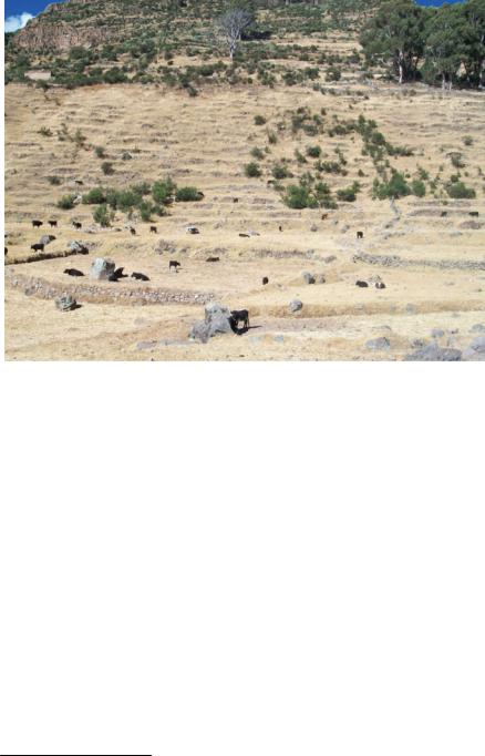
Fig. 8.3 Abandoned terraces in the Chicha-Soras valley in Apurimac. Photo L. Camara
The growing marginalization of these territories is also the result of socio-demographic changes, characterized by rural exodus events and the consequent reduction in agricultural workers. Rural social instability, which, in the 1980s, was characterized by terrorist violence, has particularly hit the rural areas of the Central Andes, especially the Apurimac and Ayacucho regions.
The presence of livestock in the terraced fields observable in Fig. 8.3 must be considered, not only as a simple breeding activity, but also as a way to keep the terraces free from unwanted sylvan vegetation. However, in many cases, the overgrazing of horses and cattle has destroyed vast terraced areas. This phenomenon is observable, not only in the elevated areas of the valleys, but also in the lower areas where the terrace systems can be the object of potential recovery.
Another pressure terraced slopes and agriculture face is both direct and indirect competition for land and water. Many production areas and pastures have been used for mining concessions, whose water demands are growing rapidly, and the pollution from mines in the soil and water sources is devastating (Del Pozo and Paucarmayta 2015).
The most important non-traditional products are asparagus (fresh and canned), grapes, avocados, artichokes, mango, etc.
130 |
L. Camara and M. B. de Mesquita |
Terrace abandonment is a clear manifestation of the transformation of traditional production methods. The progressive change in Andean agriculture is leading to social, economic, and cultural consequences and to the loss of local resources, knowledge, and agricultural landscapes. This has made evident the complex relationships that allow the whole system to function effectively.
Nevertheless, terracing has aroused great interest and calls for recovery and restoration. Two distinctly different orientations predominate: the recovery of large-scale terraces by the Peruvian State has focused on areas of monumental interest, such as the terraces around Chinchero, Pisac, Ollantaytambo, and Machu Picchu—recoveries executed by the Instituto Nacional de Cultura Cusco (National Institute of Culture, Cusco), today the “Regional Directorate of the Ministry of Culture”. The second orientation has to do with the rural development programs attempting to recover smaller terraced areas, for example DESCO SUR (Centro de Estudios y Promoción del Desarrollo Zona Sur), PRONAMACHCS (Programa Nacional de Manejo de Cuencas Hidrográficas y Conservación de Suelos), MARENASS (Proyecto de Manejo de los Recursos Naturales en la Sierra Sur); Cusichaca and others NGOs and associations recovered terraces in Arequipa, Ayacucho, Apurimac and Lima regions.
In general, this terrace recovery was almost always conditioned by an external intervention and several actors: NGOs, the State, research institutes, international cooperation agencies, private companies, development agencies, and through rural development programs. These development programs were intended to strengthen human, natural, material, financial, cultural, and social resources; combat rural poverty; improve living conditions; etc. They are implemented in the following thematic lines: environmental management and conservation of natural resources, sustainable agricultural production, orientation to agri-food for the market, management of rural tourism, rural education and technical productive training, food security, and support for strengthening institutions and local participation.
(c) Social management of water
Water management is more of a strength than a threat for the Andes peoples, who have a long tradition of managing water resources. Agriculture would not be possible without water, and various cultural, material, and religious factors were woven around these elements, consolidating a structure that would explain the importance of water in the life of Andean societies.
Terraced farming implies a great responsibility for water conservation in quantitative and qualitative terms. The careful management of water resources and the efficient use of rainwater for crops and pastures are criteria for good agricultural practices. Traditional Andean technologies are efficient in irrigation management, minimizing waste, and avoiding excessive leaching and salinization of the soil.
The hydrological cycle is constantly managed—from capturing to conserving rainwater, from infiltration processes to protecting places from which infiltrated water emerges, from domestic use to field irrigation, from ritual conception to social organization. This control is complex and integral. Each of these systems is unique
8 Terraced Landscapes in Perù: Terraces and Social Water Management |
131 |
and responds to the particular characteristics for which it was designed, but all the systems have a common root in the need to face lacking or excessive water.
Managing the natural spaces for collecting and concentrating water resources has proved to be effective for monitoring ecosystems and production activities. This approach considers the basin as the fundamental unit of territorial management and lays the foundations for a multi-sectoral production management and service provider.7
Andean companies’ need to bring water from the source to areas of use has led to technological developments combining agronomic, water, and construction knowledge adapted to the territory’s biological and topographical conditions—from the plateaus to the terraced slopes to the valley floor—as a single integrated system. The great capacity for social organization induced vast quantities of people to build and maintain large irrigation works in the inter-Andean valleys.
Currently, there is concern about the decrease in water in the valleys, which has led communities to find alternatives to rain-farming for agricultural production. Farmers say that, in the highlands, there are lagoons and springs, whose waters “do not seem to disappear.” They wonder if their ancestors faced problems related to water availability and conservation. The existence of these lagoons and springs has pushed some NGOs and government programs to re-use the technologies already present in the territory and encourage farmers to recover them. Some of these sources are as follows.
•The bofedales, ojonales or “wetlands” or “peatas” are the most important grassland ecosystems in the arid and semi-arid Peruvian highlands above 3800 m. They allow infiltration and water retention in the water table and maintain dense vegetation in the surrounding areas.
•The qochas are lakes or ponds artificially excavated or built in a natural depression. They are an ancient agricultural technique, based on the use of a dense network of channels connected to each other by a lagoon. They provide a water and soil management system used alternately for crops and grazing.
•The lagoons, tanks, or water tanks exploit a natural depression of the ground or natural ponds, or they are artificially built with the purpose of capturing and storing rainwater, allowing, through a slow infiltration, the recharge of aquifers
and the natural irrigation of prairies.
The amunas8 constitute a series of pre-Hispanic strategies for water, soil, and crop management based on the climatic-geographical challenge of the Andes. This technology works like a sponge, allowing rainwater to infiltrate inside the
7The river basin approach was used by the Ministry of Agriculture in 1974, but the program’s actions began in 1980 with the creation of the PRONAMACHS program (Programa Nacional de Manejo de Cuencas Hidrográficas y Conservación de Suelos) as a response to dialectic territorial planning policies, plans, and strategies for development.
8An initiative of the GSAAC (Gestión Social del Agua y el Ambiente en Cuencas) was to find mechanisms to recover and exploit ancient ancestral water use practices, commissioning a study about how the amunas system functions, with the objective to promote alternative actions to increase the water supply for consumption and for production activities in Andean communities.

132 |
L. Camara and M. B. de Mesquita |
cracked volcanic rocks that are found in the highland areas or in the mountain slopes (Alencastre et al. 2006). It is an artificial water supply, a recharge system for aquifers, or a way to introduce water into the subsoil, retaining and discharging it naturally. The amunas or millpu are considered “water sowing” by the rural communities, and they are carried out through community action.
•The ojos de agua or pukios (springs), streams, small streams, lagoons, and lakes
are sources that the Andean communities have used since ancient times to irrigate their terraced, flat, and hilly fields. The springs are the natural sources
where underground waters emerge from areas with fractures or faults. This water is received and, in some cases, is directed to tanks specially built to conserve and protect captured water and facilitate its distribution downstream through the so-called acequias amunadoras or channels.
•The acequias are structures that allow the transfer and distribution of water from the source of collection (rivers, streams, wetlands, etc.) to tanks or lagoons. These types of channels are not covered with any impermeable material, but are rather cuts on the ground that allow moistening of the soil and maintain a vegetative cover through the infiltration of water. These channels cross entire slopes.
Andean companies are experienced in traditional organization for water management and irrigation, which has followed similar schemes for hundreds of years. Irrigation control is often divided into a set of community institutions.9 Around traditional irrigation are interwoven various expressions of religious and cultural beliefs that are the basis of the whole social structure and explain water’s importance in the lives of farmers.
Camara (2015) found that, in almost all communities studied, water distribution is managed by a Junta de Regantes (“irrigation committee”), whose function is to distribute water to all members of the community based on membership, quantity, areas, land preparation, and other criteria determined in assembly with direct collective deliberations (Tillmann and Bueno de Mesquita 2015).
Irrigation systems in rural communities are systems of “collective action”. A family alone, or individuals, could neither (re)construct nor maintain an infrastructure necessary for the management, defense, and protection of complex irrigation structures. Within these irrigation systems, families and community members maintain the agricultural production system and participate in making collective decisions. Gerbrandy and Hoogendam (1998) believe that it is not appropriate to talk about collective rights in the internal management of an irrigation system, since the usufruct is at the individual level. Individual usufruct is not an absolute right. Instead, it starts from a context of collective decisions about the
9The studies of Guillet (1992), in the community of Lari, and of Valderrama and Escalante (1988), in the community of Yanque, both in the Colca valley, describe a complex and articulated agricultural calendar system based on a broad range of crops, with water distributed to individual fields. In both Lari and Yanque, a sort of micro-irrigation planning seems to operate under the control of the community authority.