

7 Terraced Landscapes in the Canary Islands: La Gomera … |
105 |
Digital orthophotos from 1964 and 2016 were photo-interpreted to identify the maximum surface area of terraced landscapes on La Gomera. The terraces were digitized through a GIS, obtaining polygon layers. The 1964 orthophoto allowed identification of the terraces existing at the time, when agricultural activity was at its peak. However, some of these terraces are currently in a highly deteriorated condition while others have even disappeared. Meanwhile, the 2016 orthophoto allowed identification of new terraces and it was possible to resolve some doubts which had arisen in relation to the first orthophoto due to shadows, spatial resolution limits, etc.
A digital elevation model (DEM) was subsequently used to create a digital slope model. This new raster was reclassified using the following intervals: 0°–5°, 5°–15°, 15°–25°, 25°–35°, 35°–45°, 45°–55°, 55°–65°, 65°–75°, and 75°–80.5°. The elevations from the DEM were then also reclassified according to the following intervals: 0–200, 200–400, 400–600, 600–800, 800–1000, 1000–1200, and >1200 m.
Various GIS analyses were performed to characterize the terraces and determine their current use. The terraced layer was overlaid over the following layers: slope, elevation, geology, protected areas (Protected Nature Areas and Special Areas of Conservation), and land cover.
To analyze terrace distribution in the watersheds of the island, a map was generated using the “watershed” GIS tool of the ArcGIS software. The resulting raster was converted into a layer of polygons. The smallest adjacent watersheds/basins were merged with their neighboring basins to generalize these spatial features according to the scale of the final map, thus obtaining the final layer of watersheds.
7.4Characterization of the Terraces of La Gomera
7.4.1Environmental Factors (Altitude, Slope, Lithology and Landforms)
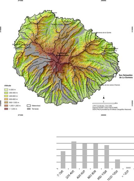
The area occupied by terraces amounts to a total of 8233.1 ha, or 22.4% of the island. They are located in almost all the watersheds of the island (Fig. 7.3), from the coast to a height above sea level of 1362.6 m.
In terms of altitudinal distribution, 78.5% of the terraced areas are concentrated between 200 and 1000 m (Fig. 7.4). At lower and upper heights, terraced landscapes represent 13.6% (1114.7 ha) and 8% (571.7 ha), respectively. An unequal altitudinal distribution was observed according to the face of the island on which they are located. In the south, leeward of the trade winds and the sea of clouds, the terraces rise above 1000 m. By contrast, in the north, the almost permanent presence of the sea of clouds between 600 and 700 m has generally limited the construction of terraces and favored the recovery of laurel forest in areas that were briefly used for farming in the 1950s and 1960s (during periods of famine and when demographic pressure was greatest) and then abandoned.
106 |
L. E. Romero Martín et al. |
Fig. 7.3 Terraces of La Gomera
Fig. 7.4 Distribution of terraced area by altitude
%
25 |
|
21.2 |
19.4 |
|
|
|
|||
20 |
|
19.6 |
18.2 |
|
|
|
|
||
15 |
|
13,6 |
|
|
10 |
|
|
|
7.0 |
|
|
|
|
|
5 |
|
|
|
1.0 |
0 |
|
|
|
|
|
|
|
|
|
|
|
|
|
Altitude (metres)
Some 39.3% (3226.7 ha) of the terraced area are located on slopes between 5° and 15°, while 30.7% (2524.1 ha) are located on slopes between 15° and 25°, where agricultural use is only recommended for terraces (Fig. 7.5). In addition, 24.3% of terraced areas have been constructed on slopes unsuitable for agricultural
7 Terraced Landscapes in the Canary Islands: La Gomera … |
107 |
Fig. 7.5 Distribution of terraced areas by slope (°)
%
45 |
|
39.3 |
|
|
|
|
|
|
|
||
40 |
|
|
|
|
|
|
|
|
|
|
|
35 |
|
30.7 |
|
|
|
30 |
|
|
|
|
|
|
|
|
|
|
|
25 |
|
|
|
|
|
20 |
|
17.7 |
|
|
|
15 |
|
|
|
|
|
10 |
5.7 |
5.8 |
|
|
|
5 |
|
|
|
||
|
0.7 |
0.1 |
0.0 |
0.0 |
|
0 |
|
||||
|
|
|
|
|
|
|
|
|
|
|
0-5 5-15 15-25 25-35 35-45 45-55 55-65 65-75 75-81
Slope (°)
use (>25°), of which 6.6% are considered highly unstable and in serious danger of collapse. The largest slope where terraces are located is 76.9° in the watershed Valle Gran Rey (Fig. 7.8). In contrast, there are also terraces on slopes <5°, representing 5.7% (469.2 ha) of the total terraced area, located in the lower part of ravines and interfluves (Figs. 7.5, 7.6, and 7.7).
From a geological point of view (Table 7.2), most of the terraces are located on the largest-sized geological deposits of the island. Some 72.0% (5929.4 ha) are
Fig. 7.6 Mouth of Hermigua ravine. Photo M. C. Iglesias López

108 |
L. E. Romero Martín et al. |
Fig. 7.7 El Cabrito ravine. Photo J. Izquierdo Valli
Table 7.2 Distribution of terraced areas by lithology
Lithology |
Area (ha) |
% |
Basaltic and trachybasaltic lava flows |
4543.0 |
55.2 |
Basaltic lava flows |
613.5 |
7.5 |
Mafic trachyte lava flows |
538.9 |
6.5 |
Basaltic lava flows and related breccias |
233.9 |
2.8 |
Subtotal |
5929.4 |
72.0 |
Basic and ultrabasic plutonic stocks |
222.5 |
2.7 |
Felsic dike swarms and associated lava flows |
184.2 |
2.2 |
Tephra cones |
312.5 |
3.8 |
Subtotal |
719.2 |
8.7 |
Colluvium and hillside deposits |
353.7 |
4.3 |
Landslide deposits, debris flows, coastal rock falls |
308.7 |
3.7 |
Alluvial deposits and ravines |
217.5 |
2.6 |
Debris avalanche of Vallehermoso |
110.9 |
1.3 |
Subtotal |
990.7 |
12.0 |
Other |
593.8 |
7.2 |
Total |
8233.1 |
100.0 |
7 Terraced Landscapes in the Canary Islands: La Gomera … |
109 |
Fig. 7.8 Ravine of Valle Gran Rey. Photo L. E. Romero Martín
located over basaltic and trachybasaltic lava flows, which constitute the remains of Miocene and Pliocene shields, while 8.7% (719.2 ha) are found over other deposits of igneous origin, such as tephra cones, intrusion of felsic dikes and basic and ultrabasic plutonic stocks. Terraces are also found over types of sedimentary deposit (12%, 990.7 ha) as the result of slope erosive activity (colluvium and landslide deposits, coastal rock falls and a debris avalanche in Vallehermoso).
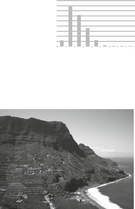
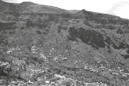
As ravines and watersheds are the dominant landforms on the island, differences are observable between the windward (N–NE) and leeward (S–SW) sides. In the S–SW, the watersheds have, on average, 30.1% terraced land, while in the N–NE side this value falls to 15.1% (Fig. 7.3). The watersheds with the highest presence of terraces are El Barranquillo (59%) in the N–NE and Barranco de Los Guirres (65.8%) in the S–SW. However, Valle Gran Rey watershed, located on the southern slope (Fig. 7.8), is the biggest contributor to the island (11.5% of the island’s terraced slopes are located here). Among those located on the northern slope, Hermigua stands out for its profuse terraces and banana cultivation (Figs. 7.9 and 7.10).
The dotted vertical line shows mean percentage value for terraced land/watershed/ island. The continuous vertical line shows mean percentage value of terraced land/ watershed.

110 |
L. E. Romero Martín et al. |
Fig. 7.9 Terraced surface area in each watershed (black) and as percentage of total terraced surface area on the island (grey).