

7 Terraced Landscapes in the Canary Islands: La Gomera … |
111 |
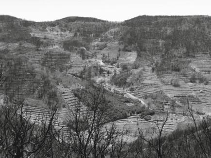
Fig. 7.10 Hermigua ravine. Photo M. C. Iglesias López
7.4.2Human Factors (Land Occupation and Protected Nature Areas)
Through an analysis of current land cover, it is possible to study the evolution of the terraced landscapes. Almost half of the terraced landscapes have been colonized by shrubby and herbaceous vegetation (48.6%), mainly by climax shrubs (Neochamaeleo pulverulentae-Euphorbietum balsamiferae, Euphorbietum berthelotii-canariensis, etc.) or natural secondary shrubs (Table 7.3). In the terraced areas that remain in cultivation today, the most notable crops are orchards (13.8%), wine grapes (8.1%) for local consumption and bananas for exportation (4.2%).
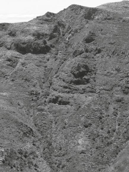
Furthermore, forests have colonized 12% of the terraced area. Evergreen forests (laurel forest and Myrica faya-Erica arborea) have colonized 8.3% of the terraced area,7 thermophilous forests 2.7%, while reforestation with foreign species represents 0.1% (Fig. 7.11).
7No terrain surface data re-colonized by evergreen forest affected by the fire of 2012 were available for this study.
112 |
|
L. E. Romero Martín et al. |
||
Table 7.3 Distribution of terraces by land cover |
|
|
|
|
|
|
|
|
|
Group |
Class |
|
Area |
% |
|
|
|
(ha) |
|
Scrub and herbaceous |
Coastal scrub |
|
1622.4 |
19.7 |
vegetation |
Secondary scrub |
|
1390.8 |
16.9 |
|
|
|||
|
Pasture |
|
983.7 |
11.9 |
|
“Escobón” shrubland |
|
4.9 |
0.1 |
Subtotal |
|
|
4001.8 |
48.6 |
Agricultural |
Herbaceous crops |
|
1138.1 |
13.8 |
|
Abandoned crops |
|
701.4 |
8.5 |
|
Vineyard |
|
667.9 |
8.1 |
|
Banana |
|
349.8 |
4.2 |
|
Greenhouse |
|
16.7 |
0.2 |
|
Tropical fruit trees |
|
13.0 |
0.2 |
|
Citrus fruit trees |
|
3.4 |
0.0 |
|
Ocean temperate fruit trees |
|
2.0 |
0.0 |
Subtotal |
|
|
2892.2 |
35.1 |
Forests and reforestation |
Laurel forest |
|
363.6 |
4.4 |
|
Myrica faya-Erica arborea |
|
321.2 |
3.9 |
|
Thermophilous forests |
|
226.2 |
2.7 |
|
Ravine vegetation |
|
49.0 |
0.6 |
|
Pinus canariensis |
|
13.7 |
0.2 |
|
Pinus halepensis |
|
7.6 |
0.1 |
|
Pinus radiata |
|
4.1 |
0.0 |
|
Eucaliptus sp. |
|
0.4 |
0.0 |
Subtotal |
|
|
985.9 |
12.0 |
BARE SOIL |
Extraction of materials, works |
|
107.6 |
1.3 |
|
Sparse vegetation |
|
71.5 |
0.9 |
|
Dumping site, graveyard |
|
2.8 |
0.0 |
|
Beach, dunes, and sandy area |
|
1.3 |
0.0 |
Subtotal |
|
|
183.2 |
2.2 |
Urbanizations and |
Dense housing developments |
|
81.0 |
1.0 |
infrastructures |
Urbanization along roads |
|
46.7 |
0.6 |
|
|
|||
|
Airports and infrastructures |
|
13.8 |
0.2 |
|
Industrial complexes |
|
6.1 |
0.1 |
|
Dispersed urbanization |
|
5.3 |
0.1 |
|
Sports, recreation, health, and education |
3.9 |
0.0 |
|
|
facilities |
|
|
|
|
Military installations |
|
2.2 |
0.0 |
Subtotal |
|
|
158.9 |
2.0 |
Water |
Dam |
|
8.9 |
0.1 |
|
Pond |
|
2.2 |
0.0 |
Subtotal |
|
|
11.1 |
0.1 |
Total |
|
|
8233.1 |
100.0 |
7 Terraced Landscapes in the Canary Islands: La Gomera … |
113 |
Fig. 7.11 Effects of the 2012 fire in Guadiana ravine. Photo J. C. Hernández Navarro
Terraces are present in 16 of the 17 Protected Nature Areas existing on the island, but only represent 8.7% (712.7 ha) of total terraced area. One of the goals of these Protected Nature Areas is the conservation of humanized landscapes. They include Valle Gran Rey Rural Park, Orone Protected Landscape (Fig. 7.12), and Barranco del Cabrito Natural Monument (Table 7.4).
Of the 25 terrestrial Special Areas of Conservation (SAC) existing in the island, 24 contain terraces, representing 20.4% (1683.3 ha) of total terraced surface area (Table 7.5). Most of the terraces are located in SAC Teselinde—Cabecera de Vallehermoso, Montaña del Cepo, Cuenca de Benchijigua—Guarimiar, Orone, Barranco del Charco Hondo, Valle Alto de Valle Gran Rey, Barranco del Cabrito, and Barranco del Cedro y Liria.
114 |
L. E. Romero Martín et al. |
Fig. 7.12 Orone Protected Landscape. Photo J. C. Hernández Navarro
7 Terraced Landscapes in the Canary Islands: La Gomera … |
115 |
|||
Table 7.4 Distribution of terraces in Protected Nature Areas |
|
|
||
|
|
|
|
|
Protected Nature Areas |
Area (ha) |
|
Terraces of the island (%) |
|
Valle de Gran Rey Rural Park |
259.3 |
3.1 |
||
Orone Protected Landscape |
163.9 |
2.0 |
||
Barranco del Cabrito Natural Monument |
118.8 |
1.4 |
||
Majona Natural Park |
44.7 |
0.5 |
||
Lomo del Carretón Natural Monument |
42.2 |
0.5 |
||
La Fortaleza Natural Monument |
16.6 |
0.2 |
||
Garajonay National Park |
14.9 |
0.2 |
||
La Caldera Natural Monument |
13.8 |
0.2 |
||
Roque Cano Natural Monument |
11.7 |
0.1 |
||
Puntallana Special Nature Reserve |
11.6 |
0.1 |
||
Charco del Conde Site of Scientific Interest |
5.7 |
0.1 |
||
Roque Blanco Natural Monument |
4.3 |
0.1 |
||
Acantilados de Alajeró Site of Scientific Interest |
4.3 |
0.1 |
||
Benchijigua Integral Nature Reserve |
0.6 |
0.0 |
||
Los Órganos Natural Monument |
0.2 |
0.0 |
||
Charco de Cieno Site of Scientific Interest |
0.0 |
0.0 |
||
Total |
712.7 |
8.7 |
||
Table 7.5 Distribution of terraces in Special Areas of Conservation |
||||
|
|
|
|
|
Special Areas of Conservation (SAC) |
|
Area (ha) |
|
Terraces of the island (%) |
Teselinde–Cabecera de Vallehermoso |
|
350.2 |
|
4.3 |
(ES7020097) |
|
|
|
|
Montaña del Cepo (ES7020098) |
|
200.2 |
|
2.4 |
Cuenca de Benchijigua–Guarimiar (ES7020107) |
|
187.4 |
|
2.3 |
Orone (ES7020039) |
|
164.0 |
|
2.0 |
Barranco del Charco Hondo (ES7020102) |
|
160.2 |
|
1.9 |
Valle Alto de Valle Gran Rey (ES7020104) |
|
131.4 |
|
1.6 |
Barranco del Cabrito (ES7020035) |
|
118.8 |
|
1.4 |
Barranco del Cedro y Liria (ES7020109) |
|
106.3 |
|
1.3 |
Majona (ES7020030) |
|
44.7 |
|
0.5 |
Laderas de Enchereda (ES7020101) |
|
43.3 |
|
0.5 |
Lomo del Carretón (ES7020037) |
|
42.2 |
|
0.5 |
Taguluche (ES7020108) |
|
37.7 |
|
0.5 |
Garajonay (ES0000044) |
|
18.9 |
|
0.2 |
La Fortaleza (ES7020034) |
|
16.6 |
|
0.2 |
Cabecera Barranco de Aguajilva (ES7020106) |
|
12.5 |
|
0.2 |
Roque Cano (ES7020032) |
|
11.7 |
|
0.1 |
Puntallana (ES7020029) |
|
11.6 |
|
0.1 |
(continued)