

losing accuracy.
To establish an arc of triangulation between two widely separated locations, a base line may be measured and longitude and latitude determined for the initial point at one end. The locations are then connected by a series of adjoining triangles forming quadrilaterals extending from each end (Figure 7). With the longitude, latitude, and azimuth of the initial points, similar data is computed for each vertex of the triangles thereby establishing triangulation stations or geodetic control stations. The coordinates of each of the stations are defined as geodetic coordinates (Figure 8).
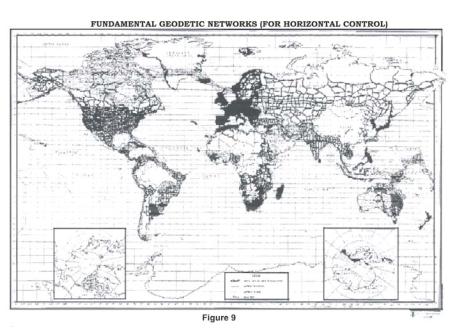
Triangulation is extended over large areas by connecting and extending series of arcs and forming a network or triangulation system. The network is adjusted in a manner which reduces
the effect of observational errors to a minimum. A denser distribution of geodetic control is achieved in a system by subdividing or filling in with other surveys. Figure 9 serves to illustrate, in a general manner, the major triangulation networks which have been established.
|
Text 10 |
at least |
по крайней мере |
to satisfy the standards |
соответствовать стандарту |
carry out |
выполнять |
either side |
каждая из сторон |
at suitable points |
в подходящих точках |
bridging wide gaps |
преодоление значительных промежутков |
13
Orders of Triangulation
There are four general orders of triangulation.
First-Order (Primary Horizontal Control) is the most accurate triangulation. It is costly and timeconsuming using the best instruments and rigorous computation methods. First-Order triangulation is usually used to provide the basic framework of horizontal control for a large area such as for a national network. It has also been used in preparation for metropolitan expansion and for scientific studies requiring exact geodetic data. Its accuracy should be at least one part in 100,000.
Second-Order, Class I (Secondary Horizontal Control) includes the area networks between the First-Order arcs and detailed surveys in very high value land areas. Surveys of this class strengthen the US National Horizontal Control Network and are adjusted as part of the network. Therefore, this class also includes the basic framework for further densification. The internal closures of Second-Order, Class I triangulation should indicate an accuracy of at least one part in 50,000. The demands for reliable horizontal control surveys in areas which are not in a high state of development or where no such development is anticipated in the near future justifies the need for a triangulation classified as Second-Order, Class II (Supplemental Horizontal Control). This class is used to establish control along the coastline, inland waterways and interstate highways. The control data contributes to the National Network and is published as part of the network. The minimum accuracy allowable in Class II of Second-Order is one part in 20,000.
Third-Order, Class I and Class II (Local Horizontal Control) is used to establish control for local improvements and developments, topographic and hydrographic surveys, or for such other projects for which they provide sufficient accuracy. This triangulation is carefully connected to the National Network. The work should be performed with sufficient accuracy to satisfy the standards of one part in 10,000 for Class I and one part in 5,000 for Class II. Spires, stacks, standpipes, flag poles and other identifiable objects located to this accuracy also have significant value for many surveying and engineering projects.
The sole accuracy requirement for Fourth-Order triangulation is that the positions be located without any appreciable errors on maps compiled on the basis of the control.
Normally, triangulation is carried out by parties of surveyors occupying preplanned locations (stations) along the arc and accomplishing all the measurements as they proceed. When distances between two points were too long for conventional methods, connections were sometimes made
14