

unknown positions to existing triangulation networks, and to relate the triangulation networks to each other. Important parameters of the earth's gravitational field and values for the earth's flattening have also been obtained.
Historical Systems
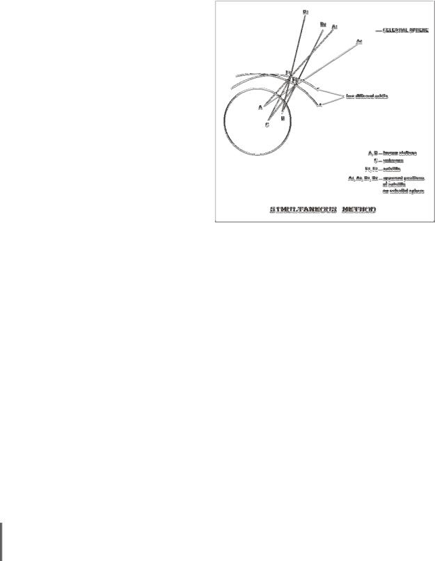
Optical tracking with the BC-4, PC-1000, MOTS, or Baker Nunn cameras consisted of photographic observations of a satellite, or flashing light on the satellite, against a background of stars. The stars, whose positions were accurately determined, provided a framework on the photographic plate or film for a determination of precise directions from camera station to satellite. Geodetic positioning work with cameras was usually performed with one camera observing simultaneously with one or more other cameras (Figure 25). Camera systems are
weather dependent and that is one major reason why they are little used today. Laser systems discussed later, are also weather dependent but their extreme accuracy justifies their use and development.
The U.S. Army developed the SECOR (Sequential Collation of Range) system and the first SECOR transponder was orbited on ANNA-1B in 1962. The SECOR system continued to be in use through 1970. The system operated on the principle that an electromagnetic wave propagated through space undergoes a phase shift proportional to the distance traveled. A ground station transmitted a phase modulated signal which was received by the satellite-borne transponder and returned to the ground. The phase shift experienced by the signal during the round trip from ground to satellite and back to ground was measured electronically at the ground station which provided as its output a digitized representation of range.
|
Text 37 |
the fact that |
то, что |
transmitter |
передатчик |
exhibit |
проявлять |
43
approach |
приближаться |
recede |
удаляться |
pitch |
высота звука |
Doppler
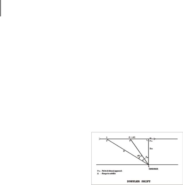
A geodetic satellite can also carry electronic signaling equipment to produce the Doppler Effect which can be used for geodetic purposes. The Doppler observational system was derived from the fact that while a satellite transmitter sends a continuous unmodulated wave at a fixed frequency, the received signal at the tracking stations exhibits a shift in frequency due to the relative velocity of the satellite and observing station. A similar phenomenon may be observed with sound waves, as the source of the sound approaches and recedes from the observer. For example, the pitch of a train whistle apparently changes as the train approaches and recedes from the observer. Although the sound waves travel at a constant rate – approximately 1080 feet per second at sea level –they become crowded together as the source approaches the observer, the wave lengths become shorter, and the pitch increases. The opposite effect takes place as the source moves away.
In Figure 26, the radio source is assumed to be moving in a straight line at a specified speed. The angle Ø is used to indicate the distance between the position of the satellite at P (time t) and the point Pm (time tm) where it will be closest to the observer. If the Doppler shift were expressed in terms of Ø, as Ø decreases, the Doppler shift decreases to zero. As the satellite recedes, the received frequency
decreases and the shift increases until the transmitter is out of range. This received frequency is actually a function of the transmitted frequency, velocity of propagation, and the rate of change of the slant range between the satellite and station. From observations at one station, the satellite period, time and distance of its closest approach, and its relative velocity can be determined. If observations are made from three or more stations, the orbital parameters may be derived.
Of all the satellite observation systems used so far, Doppler tracking has been the most fruitful. Reasons for this are: it is passive, not requiring any interrogation or directionally sensitive antennae at the receiver; the data obtained (Doppler counts) are in digital form; the radio frequencies used permit all weather day and night tracking; and accuracies achieved have
44
steadily improved. Much effort has gone into identifying and eliminating the sources of error in Doppler work. Automatic portable receiving equipment is available from several suppliers. The GEOCEIVER (geodetic receiver has played an important role in DoD observational programs. Since 1967 there have been at least four operational satellites continuously available for Doppler positioning. The National Geodetic Survey (NGS) will be using results from many Doppler stations within the United States and its possessions in support of the readjustment of the North American horizontal datum.
|
Text 38 |
lunar surface |
лунная поверхность |
outgoing |
исходящий |
appropriate |
соответствующий |
to yield range data |
сообщать данные о расстоянии |
simultaneous |
одновременный |
crustal motion |
движение земной коры |
Laser
The laser has been adapted to measuring distances over the earth's surface and for computing ranges from earth stations to satellites and the lunar surface. The laser instrument is pointed to a target and then activated by a clock at the appropriate time. The laser beam is reflected at the target by special reflectors and the returning light is detected photoelectrically, and its time of flight measured to yield range data. The laser transmitter is mounted adjacent to some type of telescope or optical device used for receiving the reflected laser beam.
In satellite laser ranging, the interval between the outgoing and returning pulse from the satellite is measured very accurately and then transformed into a range measurement which is corrected for atmospheric refraction. Laser ranging is possible even when the satellite is in the earth's shadow and during daylight hours.
Simultaneous laser ranging to a near-earth satellite from two sites is used to determine the coordinates of one laser site relative to the fixed position of the other site and simultaneously the inter-site distance. NASA has used laser tracking since 1972 to measure the distance between points in North America. They have been testing the accuracy of laser tracking in measuring the crustal motion between points on opposite sides of the San Andreas Fault and plan to make repeated measurements of baselines across the fault over a number of years. Simultaneous laser tracking has also been achieved between an east coast site and Bermuda enabling a
45
determination of the Bermuda site's relative location (North American Datum) and the baseline between the two sites.
Laser ranging data has been incorporated into the development of world geodetic systems by the Smithsonian Astrophysical Observatory (SAO) and the Department of Defense (DoD). NASA has also included laser data in their development of gravitational models. Laser data is also being used for polar motion and earth rotation studies.
Doppler Satellite Surveys
Doppler satellite surveying is a method of determining positions of points on the earth's surface by observing the Doppler shift of radio transmissions from satellites of the U.S. Navy Navigation Satellite System (NNSS. NNSS was developed for the Navy as a worldwide all-weather navigation system, and provides position fixes at time intervals of 2 hours or less. Observations of these satellites began in earnest in 1971, when portable tracking receivers became available to establish precise positions on the earth's surface. Since then, the application of Doppler satellite surveying techniques expanded, until today they are used worldwide.
|
Text 39 |
currently |
в настоящее время |
approximately |
приблизительно |
broadcast |
передавать, транслировать |
cause |
заставлять |
acquire |
получать, приобретать |
improve |
улучшать |
System Description
The NNSS satellites currently operational are in circular polar orbits approximately 1000km above the earth's surface. The time to complete an orbit (orbital period) is approximately 105 minutes. The earth's rotation causes a satellite to cross the Equator on each revolution approximately 26° in longitude west of the previous crossing. Each satellite transmits what is referred to as the "broadcast ephemeris", which describes the satellite's position in space. The ephemeris is a predicted orbit based on Doppler observations previously acquired by four tracking stations located in the United States.
Doppler satellite observations, reduced using the broadcast ephemeris, yield point positions with sufficient accuracy to satisfy the requirements of many NNSS satellite users. There exists a more
46