

is embodied in several recent moving-base instruments. The gravity gradient at a point is a tensor, since it is the derivative of each component of the gravity vector taken in each sensitive axis. Thus, the value of any component of the gravity vector can be known all along the path of the vehicle if gravity gradiometers are included in the system and their outputs are integrated by the system computer. In theory, an accurate gravity model will be computed in real-time and a continuous map of normal gravity, elevation, and anomalous gravity will be available.
|
Text 49 |
for example |
например |
as well as |
а также |
due to |
из-за |
be equal to |
равняться |
deal with |
иметь дело с |
Chapter VIII |
The World Geodetic System |
Because of the inability of the large geodetic systems such as the North American Datum (NAD), European Datum (ED), and Tokyo Datum (TD), to provide a basis for expression of intercontinental geodetic information, a unified world system became essential. The Department of Defense, in the late 1950's began to develop the needed world system to which geodetic datums could be referred and compatibility established between the coordinates of widely separated sites of interest. Efforts of the Army, Navy and Air Force were combined leading to the DoD World Geodetic System 1960 (WGS
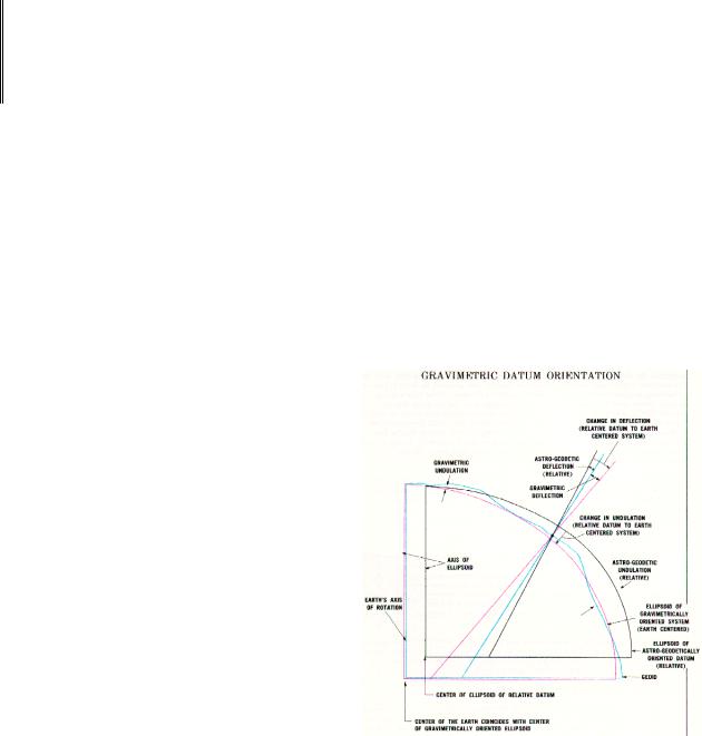
60). In accomplishing WGS 60, a combination of available surface gravity data, astrogeodetic data and results from HIRAN and Canadian SHORAN surveys were used to define a bestfitting ellipsoid and an earth-centered orientation for each of the initially selected datums (Chapter IV). (The datums are relatively oriented with respect to different portions of the geoid by the astro-geodetic methods already described,) (Figure 16). The sole contribution of satellite data to the development of WGS 60 was a value for the ellipsoid flattening which was obtained from the nodal motion of a satellite.
58