- •Text 1
- •Introduction
- •Text 2
- •Chapter 1 History of Geodesy
- •Text 3
- •Text 4
- •Text 5
- •Ellipsoid of Revolution
- •Text 6
- •Geoid
- •Text 7
- •Chapter III Geodetic Surveying Techniques
- •Text 8
- •Horizontal Positioning
- •Text 9
- •Triangulation
- •Text 10
- •Orders of Triangulation
- •Text 11
- •Trilateration
- •Text 12
- •Traverse
- •Text 13
- •Celestial Techniques
- •Text 14
- •Vertical Positioning
- •Text 15
- •Chapter IV Geodetic Systems
- •Text 16
- •Orientation of Ellipsoid to Geoid
- •Text 17
- •Text 18
- •Text 19
- •Text 20
- •Text 21
- •Text 22
- •Text 23
- •Text 24
- •Text 25
- •Text 26
- •Chapter V Physical Geodesy
- •Text 27
- •Text 28
- •Text 29
- •Text 30
- •Text 31
- •Text 32
- •Text 33
- •Text 34
- •Text 35
- •Text 36
- •Chapter VI Satellite Geodesy
- •Text 37
- •Text 38
- •Text 39
- •Text 40
- •Text 41
- •Text 42
- •Text 43
- •Text 44
- •Text 45
- •Text 46
- •Text 47
- •Text 48
- •Text 49
- •Text 50
- •Text 51
- •Text 52
- •ГЕОДЕЗИЧЕСКИЕ ТЕРМИНЫ
earth satellites.
|
Text 14 |
locked in position |
жестко закрепленный в положении |
an upright position |
вертикальное положение |
at least |
по крайней мере |
at the same time |
в то же время |
the only |
единственный |
mountainous areas |
гористая местность |
the degree of accuracy |
степень точности |
far apart |
расположенные далеко друг от друга |
Vertical Positioning
Vertical surveying is the process of determining heights – elevations above the mean sea level surface. As noted earlier, the geoid corresponds to the mean level of the open sea. In geodetic surveys executed primarily for mapping purposes, there is no problem in the fact that geodetic positions are referred to an ellipsoid and the elevations of the positions are referred to the geoid. However, geodetic data for missiles requires an adjustment in the elevation information to compensate for the undulations of the geoid above and below the regular mathematical surface of the ellipsoid. The adjustment uses complex advanced geodetic techniques. One method based on Stokes' Theorem is mentioned in the discussion of physical geodesy (Chapter V).
Precise geodetic leveling is used to establish a basic network of vertical control points. From these, the height of other positions in the survey can be determined by supplementary methods. The mean sea level surface used as a reference (vertical datum) is determined by obtaining an average of the hourly water heights for a period of several years at tidal gauges.
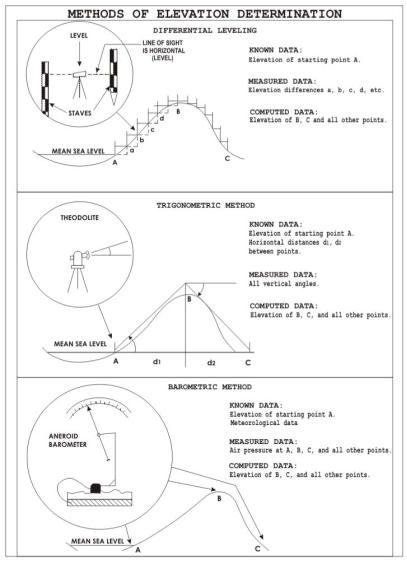
There are three leveling techniques – differential, trigonometric, and barometric – which yield information of varying accuracy (Figure 14).
Differential leveling is the most accurate of the three methods. With the instrument locked in position, readings are made on two calibrated staffs held in an upright position ahead of and behind the instrument. The difference between readings is the difference in elevation between the points
The optical instrument used for leveling contains a bubble tube to adjust it in a position parallel to the geoid. When properly "set up" at a point, the telescope is locked in a perfectly horizontal
18

(level) position so that it will rotate through a 360 arc. The exact elevation of at least one point in a leveling line must be known and the rest computed from it.
Trigonometric leveling involves measuring a vertical angle from a known distance with a theodolite and computing the elevation of the point. With this method, vertical measurements can be made at the same time horizontal angles are measured for triangulation. It is, therefore, a somewhat more economical method but less accurate than differential leveling. It is often the only practical method of establishing accurate elevation control in mountainous areas.
Figure 14.
In barometric leveling, differences in height are determined by measuring the difference in atmospheric pressure at various elevations. Air pressure is measured by mercurial or aneroid barometers, or a boiling point thermometer. Although the degree of accuracy possible with this method is not as great as either of the other two, it is a method which obtains relative heights
19
