

accurate "precise" ephemeris which is generated for selected NNSS satellites from Doppler observations acquired by a tracking network (called TRANET) composed of 15 to 20 stations. The positioning accuracies for single station observations are greatly improved when using the precise ephemeris. These ephemerides are computed by the Defense Mapping Agency (DMA to support geodetic applications requiring point positions of one-meter accuracy.
|
Text 40 |
to position |
определять координаты |
a pass |
проход |
express |
выражать |
directly |
непостредственно |
employ |
применять |
thorough |
тщательный |
data reduction |
приведение данных |
Modes of Observation
Points on the earth's surface can be positioned by various modes (point positioning, simultaneous point positioning, translocation, semi short-arc or short-arc) using either the broadcast ephemeris or the precise ephemeris.
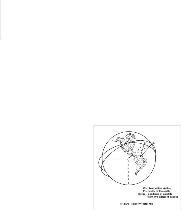
In the point-positioning mode, multiple passes collected with a single Doppler receiver are used with an ephemeris to determine an independent station position in geocentric coordinates (X, Y, Z) referenced to the Earth-centered satellite coordinate system (Figure 27). The geocentric coordinates can also be expressed in geodetic coordinates (latitude, longitude, and height above ellipsoid). Doppler positions determined with
the precise ephemeris can be directly transformed to the World Geodetic System 1972 (WGS-72) discussed in Chapter VIII.
When employing the point-positioning mode as the Doppler surveying technique, the user may wish to transform the Doppler satellitederived geocentric coordinates to the local geodetic system. The process of deriving the coordinate shifts and transforming the Doppler
position requires a thorough understanding of
Figure 27
47

datum transformation concepts and procedures. Occupation of a station with known local geodetic coordinates allows the transformation parameters to be derived for subsequent use with Doppler positions that were not established on a station tied to the local geodetic system.
In the simultaneous point-positioning mode, stations are simultaneously occupied in figures of two or more. The data are independently reduced as in the point-positioning mode and differenced to form relative positions. The simultaneous observations are performed during a common time period, but do not necessarily include common satellite passes.
In the translocation mode, observations are simultaneously collected, usually at two stations. This mode is employed to obtain very accurate relative positions, even if the precise ephemerides are not available. When the broadcast ephemeris is used, statistical correlation performed during data reduction improves the accuracy of the positioning. The principal error sources affecting an individual satellite position fix are the ephemeris errors and refraction errors. Improved compensation for these errors is possible when the same signal is received at separate sites. The maximum spacing between sites
is generally limited to approximately 500km (or less if comparability with existing control is to be maintained) so that desirable portions of satellite passes can be tracked simultaneously. During processing, enforcement of simultaneity of data points is optional. When simultaneity is enforced, it is generally referred to as rigorous translocation (Figure 28).
The short-arc and semishort-arc modes allow for small adjustments in the orbit instead of holding the satellite ephemeris fixed, as is done for the other methods. The translocation method, for example, assumes that orbit errors affect positioning of all sites in the same way, whereas the short-arc technique adjusts the reference orbit while simultaneously solving for positions. In short-arc processing, six orbital parameters are allowed to adjust. The method becomes semishort-arc processing when one to five parameters are adjustable.
48
Short-arc, semishort-arc, translocation and simultaneous point positioning are all used for relative positioning. In a survey scheme, one or more base station positions are generally held fixed. These fixed positions usually have a known position on a given geodetic datum. While data are being collected at the fixed station (s), one or more additional
receivers are circulated among the various unknown stations comprising the net. The data collected simultaneously are subjected to postprocessing to determine a position relative to the base stations (Figure 29).
Although point positioning is the least accurate mode to use when only the broadcast ephemeris is available, this technique can be performed with a single receiver and fairly simple computations. Translocation and short-arc techniques are the most accurate modes when the precise ephemeris is not available, but for these modes, field and computational procedures are more complex.
Because NNSS satellites are capable of providing the broadcast ephemeris, it may be more economical to use the broadcast ephemeris rather than the precise ephemeris to meet the survey requirements. This can reduce significantly the period of occupation for a station. Data processing can also be performed more quickly because no time is lost waiting for posttracking orbital data in order to generate the precise ephemeredes.
|
|
Text 41 |
|
а great deal |
много |
|
||
|
oblateness |
сплющенность |
|
perturb / perturbation |
возмущать / возмущение |
|
drag |
сопротивление |
|
to vary from point to point |
изменяться от точки к точке |
|
in terms of |
в виде |
Harmonic Analysis of Orbital Data |
|
|
49

A great deal of study has been done regarding the effect of the earth's gravitational attraction on satellite motion. The fact that there are a number of perturbing factors has already been mentioned – the uneven distribution of the earth's mass, the oblateness of the earth, atmospheric drag, the effects of the planets, sun and moon, and electromagnetic effects. The perturbations are measured by observing the position of the satellite in orbit around the earth. As observational data accumulates, orbital parameters become more precisely defined and reliable earth-centered positioning becomes available. An analysis of orbital data can also be used to develop an expression of the earth's external gravity field for a better interpretation of the shape of the geoidal surface through spherical harmonics. (The Appendix contains a discussion of spherical harmonics.) Although a complete analysis of orbital data requires consideration of all perturbing effects, the earth itself is the only perturbing body of major consequence in the study of nearearth satellite motion. The effects of the sun, moon, and atmosphere are removed so that only the effects of earth's shape and uneven mass distribution remain.
The uneven distribution of the earth's mass causes the force of gravity to vary from point to point on the surface and in external space. While force of gravity is measured at points on the surface with highly sensitive instruments, mathematical procedures are required to analyze orbital perturbations and to express the gravitational potential. The gravitational potential may be explained in terms of potential surfaces – surface to which the force of gravity is always perpendicular. If the earth were a perfect non-rotating
sphere with homogeneous mass distribution, the potential surface would be spherical in shape. The fact that the earth is shaped more like an ellipsoid than a sphere causes the potential surface to be shaped more like an ellipsoid. Actually, the earth is neither spherical nor ellipsoidal. The potential surface bulges where there is excessive mass and it is depressed in areas of mass deficiency. The undulating surface described earlier as the geoid is a potential surface of the real earth. The diagram in Figure 30 illustrates the three surfaces just discussed.
The most convenient way to express the gravitational potential is in terms of a series of spherical harmonics mentioned above. The coefficients of the various harmonic terms are functions of the various orbital perturbations. A few are directly related to the shape of the earth and the remainder to the uneven distribution.
50