

As military distance requirements increased, positioning information of local or even national scope became unsatisfactory. The capabilities of the various weapon systems increased until datums of at least continental limits were required.
The Major Datums Today
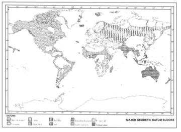
The best solution (to meeting the increased military distance requirements) was the establishment of a "single" datum for a large area and adjusting all local systems to it. The North American, European, and Tokyo Datums were (initially) selected for this purpose. (WGS 60, Chapter VIII). Other major geodetic datums of the world include the Arc and Adindan Datums in Africa, the Australian Geodetic, South American 1969, Indian and the Russian Pulkovo 1942 Datum (Figure 19).
|
Figure 19 |
|
Text 21 |
through the years |
на протяжении лет |
be officially designated |
быть официально принятым |
formally agree |
формально соответствовать |
to fit into |
вписываться, подходить |
adjust into a system |
вписывать в систему |
be in work |
использоваться |
a mean value |
среднее значение |
The North American Datum, 1927
The first official geodetic datum in the United States was the New England Datum, adopted in 1879. It was based on surveys in the eastern and northeastern states and referenced to the Clarke 1866 Ellipsoid. Through the years this datum was extended to the south and west and in 1901,
26
the extended network was officially designated the United States Standard Datum. The triangulation station Meades Ranch in Kansas was selected as the origin. In 1913, Canada and Mexico formally agreed to base their triangulation networks on the United States system. The datum was then renamed the North American Datum. Adjusting new surveys to fit into the network created many problems and, therefore, during the five-year period 1927-1932 all available first-order data were adjusted into a system now known as the North American 1927 Datum. The origin is still Meades Ranch and the datum is computed on the Clarke 1866 Ellipsoid which was oriented by a modified astro-geodetic method. The system not only incorporated Canada and Mexico but there are connections to the South American Datum 1969 through the West Indies and Central America. A new adjustment of the system is currently (1982) in work. The finished product will be called the North America Datum 1983 (NAD 83). It will be a geocentric datum, i.e. the center of the ellipsoid will be referenced to the Earth's center of mass. The minor axis of the ellipsoid will be oriented towards a universally accepted mean pole (a mean value for the Earth's axis of rotation).
Text 22
Выражения:
be located |
располагаться |
fill the gap |
заполнять промежуток |
The European Datum
The initial point of this system is located at Potsdam, Germany. Numerous European national systems have been joined into a large datum based upon the International Ellipsoid which was oriented by the astro-geodetic method. The US Map Service, now known as the Defense Mapping Agency Hydrographic/Topographic Center, connected the European and African triangulation chains and filled the gap of the African arc measurement from Cairo to Cape Town. This work related the Adindan Datum in North Africa, which roughly follows the twelfth Parallel, and the Arc Datum, extending from the Equator to the Cape, to the European Datum. Through common survey stations, a datum transformation was derived between the old Russian Pulkovo 1932 and European systems. This extended the European Datum eastward to the 84th meridian. In 1946 the Pulkovo 1932 system was united with a basic Siberian network and the new datum was designated the "1942 Pulkovo System of Survey Coordinates" (Pulkovo Datum 1942). Additional ties across the Middle East connected the European with the Indian Datum.
27
|
Text 23 |
in terms of |
относительно |
by means of |
при помощи |
be situated |
располагаться |
result in |
выражаться в чем-нибудь |
prevent from |
не позволять |
be/provide an adequate fit |
обеспечивать соответствующий подгон |
provide agreement with |
согласовывать |
The Tokyo Datum
The third of the initially selected datums has its origin in Tokyo. It is defined in terms of the Bessel Ellipsoid and oriented by means of a single astronomic station. With triangulation ties through Korea, the Tokyo Datum is connected with the Manchurian Datum. Unfortunately, Tokyo is situated on a steep geoid slope and the single-station orientation has resulted in large systematic geoid separations as the system is extended from its initial point.
For military distance and direction problems limited to continental areas or smaller, the large datums were satisfactory. However, while they are improvements over the limited national datums, they too have serious deficiencies which prevent them from providing the geodetic information required for intercontinental ballistic missiles.
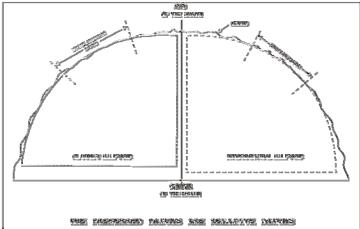
Figure 20
It is true that the North American Hiran tie permits connection of the European Datum and the North American Datum. This, however, does not completely solve the problem, for both the North American and European Datums are relative (Figure 21). While in each case the ellipsoid chosen is an adequate fit in the area of the origin, neither provides a good fit for the entire earth. Also, the process of connecting various datums by means of intervening datums or triangulation ties allows errors to accumulate which do not always provide agreement with newly observed data.
Text 24
28
as listed |
в соответствии со списком |
a vast amount |
широкое многообразие |
а traverse type |
тип теодолитного хода |
be effected by |
подвергаться влиянию |
the oldest in use |
использоваться дольше всего |
much too |
слишком |
as a result |
в результате |
for this reason |
по этой причине |
the least satisfactory |
наименее подходящий |
The South American Datum 1969 |
|
In 1965 the Working Group for the Study of the South American Datum was asked by the Committee for Geodesy of the Cartographic Commission of the Pan American Institute of Geography and History (PAIGH) to establish one consistent geodetic datum for the entire continent of South America. In June 1969, the "South American Datum 1969" was accepted by the Commission at the IX General Assembly of PAIGH in Washington, D.C. This datum is computed on the GRS 67 Ellipsoid as listed in Chapter II. CHUA, the National datum point of Brazil was taken to be the origin. A vast amount of triangulation, Hiran, astronomic, and satellite data were incorporated in the solution, and the datum now provides the basis for a homogeneous geodetic control system for the continent.
The Australian Geodetic Datum
The survey net of Australia consists of 161 sections which connect 101 junction points and form 58 loops. Virtually all the surveys are of the traverse type in which distances were determined by electronic measuring equipment. There are 2506 stations and the total length of the traverse is 33,100 miles. A complete readjustment of the geodetic network was made in 1966 using the GRS 67 Ellipsoid as listed in Chapter II. Tasmania has been connected and a tie to New Guinea and the Bismarck Archipelago was affected by a traverse up Cape York and the USAF Hiran network of 1965. This tie placed an additional 135 points on the Australian Geodetic Datum.
The Indian Datum
The Indian Datum has been used for India and several adjacent countries in Southeast Asia. It is computed on the Everest Ellipsoid with its origin at Kalianpur in Central India. Derived in 1830, the Everest Ellipsoid is the oldest of the ellipsoids in use and is much too small. As a result, the datum cannot be extended too far from the origin or very large geoid separations will occur. For this reason and the fact that the ties between local triangulation in Southeast Asia are typically weak, the Indian Datum is probably the least satisfactory of the major datums.
29