

|
Text 5 |
by convention |
обычно, условно |
designated by the letter |
обозначенный буквой |
listed below |
перечисленные ниже |
have utility in … |
использоваться в … |
be in use |
находить применение |
be named for … |
носить ч-н имя |
Ellipsoid of Revolution
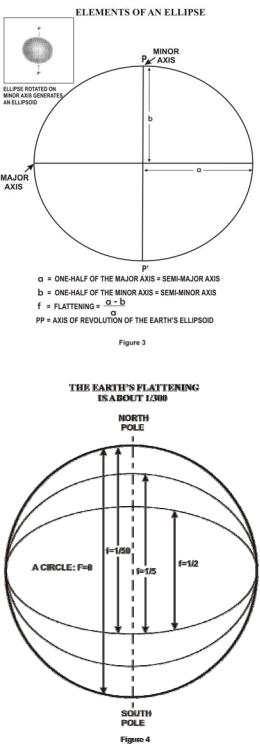
Since the earth is in fact flattened slightly at the poles and bulges somewhat at the equator, the geometrical figure used in geodesy to most nearly approximate the shape of the earth is an ellipsoid of revolution. The ellipsoid of revolution is the figure which would be obtained by rotating an ellipse about its shorter axis (Figure 3).
An ellipsoid of revolution is uniquely defined by specifying two dimensions. Geodesists, by convention, use the semimajor axis and flattening. The size is represented by the radius at the equator – the semimajor axis – and designated by the letter, a. The shape of the ellipsoid is given by the flattening, f, which indicates how closely an ellipsoid approaches a spherical shape. The difference between the ellipsoid of revolution representing the earth and a sphere is very small (Figure 4).
The ellipsoids listed below have had utility in geodetic work and many are still in use. The older ellipsoids are named for the individual who derived them and the year of development is given. The international ellipsoid was developed by Hayford in 1910 and adopted by the International Union of Geodesy and Geophysics (IUGG) which
6
recommended it for international use.
At the 1967 meeting of the IUGG held in Lucerne, Switzerland, the ellipsoid called GRS-67 in the listing was recommended for adoption. The new ellipsoid was not recommended to replace the International Ellipsoid (1924), but was advocated for use where a greater degree of accuracy is required. It became a part of the Geodetic Reference System 1967 which was approved and adopted at the 1971 meeting of the IUGG held in Moscow. It is used in Australia for the Australian Geodetic Datum and in South America for the South American Datum 1969.
The ellipsoid called GRS-80 (Geodetic Reference System 1980) was approved and adopted at the 1979 meeting of the IUGG held in Canberra, Australia. The ellipsoids used to define WGS 66 and WGS 72 are discussed below.
NAME |
EQUATORIAL RADIUS |
FLATTENING |
WHERE USED |
Krassowsky (1940) |
6,378,245m |
1/298.3 |
Russia |
International (1924) |
6,378,388 |
1/297 |
Europe |
Clarke (1880) |
6,378,249 |
1/293.46 |
France, Africa |
Clarke (1866) |
6,378,206 |
1/294.98 |
North America |
Bessel (1841) |
6,377,397 |
1/299.15 |
Japan |
Airy (1830) |
6,377,563 |
1/299.32 |
Great Britain |
Everest (1830) |
6,377,276 |
1/300.80 |
India |
WGS 66 (1966) |
6,378,145 |
1/298.25 |
USA/DoD |
GRS 67 (1967) |
6,378,160 |
1/298.25 |
Australia, South America |
WGS 72 (1972) |
6,378,135 |
1/298.26 |
USA/DoD |
GRS 80 (1979) |
6,378,137 |
1/298.26 |
|
The possibility that the earth's equator is an ellipse rather than a circle and therefore that the ellipsoid is triaxial has been a matter of scientific controversy for many years. Modern technological developments have furnished new and rapid methods for data collection and since the launching of the first Russian sputnik, orbital data has been used to investigate the theory of ellipticity.
A second theory, more complicated than triaxiality, proposed that satellite orbital variations indicate additional flattening at the South Pole accompanied by a bulge of the same degree at the North Pole. It was also contended that the northern middle latitudes were slightly flattened and the southern middle latitudes bulged in a similar amount. This concept suggested a slight pearshaped earth and was the subject of much public discussion. Modern geodesy tends to retain the ellipsoid of revolution and treat triaxiality and pear shape as a part of the geoid separation (to be discussed later).
7