


While it is possible to derive harmonic coefficients from observed gravity, the method is limited due to the lack of high quality worldwide gravity coverage. The computation of coefficients from satellite data also has its limitations. There are many coefficients that are not well defined from tracking data due to the small magnitude of the orbital perturbations at geodetic satellite altitudes. In addition, satellites orbiting at different inclinations are needed to reduce the correlation between the computed coefficients. For best results, the current practice is to combine tracking data with available surface-gravity data when solving for the spherical harmonic coefficients of the earth's gravitational field.
|
Text 42 |
pertinent |
относящийся |
deployment |
размещение |
libration |
колебание, качание, либрация |
retroreflector |
уголковый отражатель |
ranging |
дальнометрия |
enable |
позволять |
Chapter VII |
Other Developments in Geodesy |
Many pertinent developments have occurred since the last revision of this publication. This chapter provides a place for subjects of interest that are not discussed in the other chapters. Some of the areas of new geodetic developments are: satellite laser ranging (Chapter VI), lunar laser ranging, very long baseline interferometry, satellite radar altimetry, the NAVSTAR Global Positioning System, satellite-to-satellite tracking, and inertial surveying.
Lunar Laser Ranging
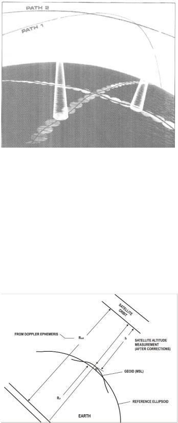
In July 1969, the first men to set foot on the moon performed a number of tasks of scientific importance. Among these tasks was the deployment of a rack structure carrying an array of 100 fused silica retroreflectors designed to return some of the light of a pulsed laser beam to the telescope to which the laser equipment is coupled. These retroreflectors are a part of an Apollo experiment called LURE (Lunar Laser Ranging Experiment. LURE was designed to obtain extremely accurate measurements of the range from known locations on the surface of the earth to the lunar based retroreflectors and enable the improvement of our knowledge of the rotation of the earth and the moon about their center of mass and the moon's librations and motion about the earth.
Text 43
51

superimposing |
наложение |
relative phase delay |
относительное фазовое смещение |
a resultant disturbance |
результирующие помехи |
radio radiation |
радиоизлучение |
atmospheric variations |
неоднородность атмосферы |
Very Long Baseline Interferometry
Observations of extragalactic radio sources such as quasars can provide the geodetic information to determine the vector separations between the antennas of two widely separated radio telescopes. The components of the vector are its length and direction. To accomplish this, it is necessary to measure very accurately the difference in the time of arrival, recorded at the two antennas, of a particular wavefront from a given (point) source of radio radiation. The phenomena called interference, in Very Long Baseline Interferometry (VLBI), are produced by electronically superimposing the recorded signals to produce a resultant disturbance or "interference" pattern. The theoretical expression for the relative phase delay shows it to be a function of the source direction, the antenna locations, the relative clock error between the two sites, the time of day, the model atmosphere employed, the earth's tidal parameters, the radio frequency at which the observation is made, etc. Proper account must also be taken of the earth's rotation. Two of the main limiting factors in the VLBI technique are clock stability and atmospheric variations. A major goal of VLBI is to reduce the uncertainty in intercontinental baselines to the centimeter level.
VLBI derived baselines have already contributed scale information to the development of the DoD World Geodetic System in 1972. Baselines accurate to the centimeter level would function as standards of comparison for future world systems. Other applications of VLBI include the determination of polar motion, variations in the earth's rotation, and the monitoring of motions of the major plates that compose the earth's crust.
|
Text 44 |
remote sensing |
дистанционное зондирование |
delay |
задержка |
one-half the product |
половина производного значения |
readily at hand |
находиться под рукой в готовом виде |
sophisticated |
сложный |
incorporate |
включать |
Satellite Radar Altimetry
52
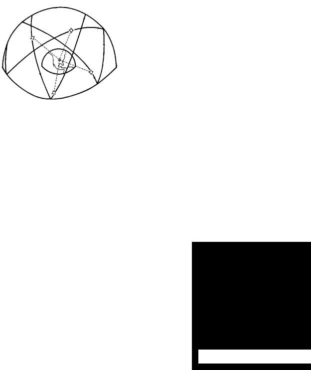
The development of orbiting space satellites from which microwave remote sensing of the earth can be achieved has provided a new instrument to the geodesist which measures directly the shape of the geoid in the ocean areas. The satellite altimeter consists of a downward ranging radar which measures the time delay from the transmission to the reception of a pulse of energy (Figure 31). The observed one-way distance from the transmitting antenna to the surface is equal to one-half the product of the time delay and the speed
of light. From this distance or height, the local surface effects such as tides, winds and currents are removed to obtain the satellite height (h) above the geoid (Figure 32). With a precise Doppler ephemeris available for the satellite, the radius (Rsat) to the satellite, determined for the time of each observation, along with the radius (RØ) to the ellipsoid are readily at hand. It is then possible to compute the geoid height (N) by subtracting the radius RØ and the satellite height h from Rsat.
The Skylab spacecraft, launched in 1973, provided the first opportunity for satellite based radar altimetry. It was basically a research mission for which data was obtained for the designing of future altimeters. The GEOS-3 altimeter which incorporates many of the design features that were tested in the Skylab altimeter was launched in 1975 and provided geoid measurements over the water areas of the earth from 65°N to
65°S. The SEASAT altimeter which was a more sophisticated instrument with greater measurement capabilities was launched in June 1978 and added data from 72°N to 72°S.
53
|
Text 45 |
comprehensive |
разносторонний |
position determination |
определение системы координат |
result in |
выражаться в |
be responsive to equirements |
отвечать за выполнение требований |
in order to |
для того, чтобы |
call for |
требовать |
as to |
относительно |
The NAVSTAR Global Positioning System
Scientists, engineers, and planners have been tasked with making comprehensive studies of currently available navigation systems as part of an effort to devise a system capable of meeting the requirements of the United States after 1980. Since the late-1950s both military and civilian agencies have actively and independently pursued the idea of position determination and navigation using satellites. This resulted in the development of several systems with a multitude of specialized equipment responsive to particular mission requirements with varying degrees of accuracy and capabilities. In order to integrate the independent efforts of the military services, the Department of Defense issued a memorandum in 1973 naming the Air Force as the Executive Service for the initial development of a future Defense Navigation Satellite System (DNSS), designated the NAVSTAR Global Positioning System (GPS).
The GPS concept calls for a precise navigation system divided into three segments: space segment, control segment and user equipment segment. The space segment will consist of six orbital planes of satellites at inclinations of 55° in circular orbits at an altitude of 20,200 km (Figure 33). Each plane is to eventually contain three satellites. Each satellite will broadcast signals containing information as to its position. This broadcast will include an orbital ephemeris referenced to the DoD World Geodetic System. The control segment
will be the ground stations necessary to track the satellites, monitor the system operation and periodically provide corrections to the navigation and time signals. The user segment will consist of the equipment necessary to convert the satellite signals into useful navigation information. By receiving signals from four satellites, the user, whether stationary or moving, can calculate his precise time, three-dimensional position and, if moving, this three-dimensional velocity. Position
54