

Reference Ellipsoid 1967, the parameters of which correspond to the Geodetic Reference System 1967. A simple formula will convert 1967 theoretical (or normal) gravity to the newer more accurate 1980 system, GRS 80 (Chapter II). A number of different procedures can be used to reduce a gravity measurement from the physical surface to sea level and, depending upon which procedure is used, different types of gravity anomalies result. The most common type of gravity anomaly used for geodetic applications is the so-called free-air gravity anomaly.
Since there are variations in the densities of the earth’s crustal materials as well as terrain variations, the observed gravity of the earth varies irregularly from point to point. As a result the surface known as the geoid is an irregular figure. As explained earlier, the distance between the mathematical ellipsoid and the actual geoid is called the undulation of the geoid. Since the geoid is so irregular, geoid undulations cannot be computed directly but must be determined point by point. Gravity measurements provide the observational data for these computations.
The word, anomaly, as used in geodesy refers to a deviation from the normal and can be used either for a single point or to describe a regional or area effect. To represent an area of the earth’s surface, the gravity measurements (anomalies) within the area are averaged by some specialized technique to produce a mean value. This may be done for areas of different size such as the one degree by one degree square. To make use of the anomalies, the observed gravity must be reduced to a common frame of reference, the geoid – mean sea level. The reductions may take into account the elevation above (or below) sea level and can account for the mass between the point and sea level, the surrounding terrain, and the assumed structure of the earth’s crust (Figure 21).
Figure 21
|
Text 34 |
in other words |
другими словами |
immediate vicinity |
непосредственная близость |
under consideration |
рассматриваться |
mass surplus |
избыточная масса |
39
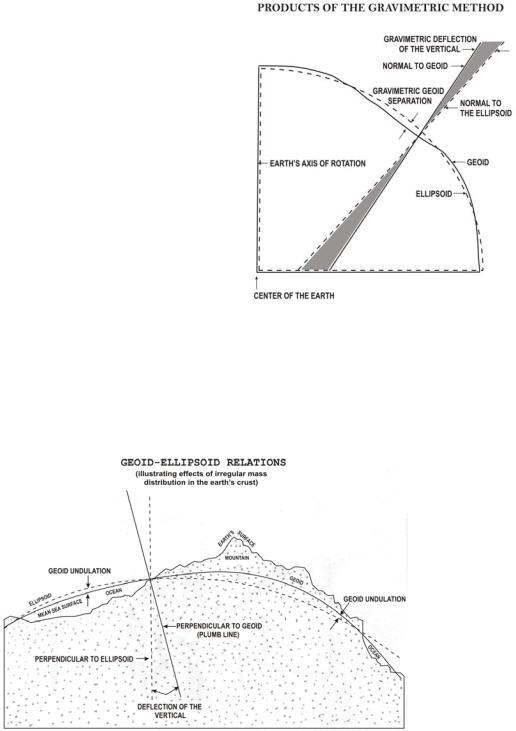
Undulation and Deflections by the Gravimetric Method
The method providing the basis from which the undulations of the geoid may be determined from gravity data was published in 1849 by a
British scientist, Sir George Gabriel Stokes. However, the lack of observed gravity data prevented its application until recent years. In 1928, the Dutch scientist, Vening Meinesz, developed the formulas by which the gravimetric deflection of the vertical (Figure 22) can be computed.
The computation of the undulations of the geoid and the deflections of the vertical require extensive gravity observations. The areas immediately surrounding the computation point require a dense coverage of gravity observations and detailed data
must be obtained out to distances of about 500 miles. A less dense network is required for the remaining portion of the earth. While the observational requirements for these computations appear enormous, the results well justify the necessary survey work.
Figure 23
Figure 23 shows how the mass surplus of the mountains and the mass deficiency of the oceans cause the deflections of the vertical and the undulations of the geoid. A mountain mass attracts the plumb line from the normal of the ellipsoid. Likewise the mass deficiency of the ocean does not attract the plumb line. These effects of the mass anomalies contribute to the deflection of the vertical. However, both deflections of the vertical and undulation values result from density
40
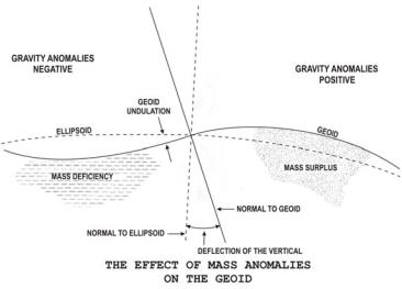
variations throughout the earth. In the area of mass surplus, the observed gravity (reduced to sea level considering only the elevation) is generally greater than the theoretical value, and the anomalies are positive. In the areas of mass deficiency, the observed (reduced in the same manner) is generally smaller than the theoretical value and the anomalies
are negative (Figure 24).
Figure 24
The deflections and undulations computed with sufficient gravity information are considered absolute values referred to an earth-centered reference ellipsoid. In other words, the axis of rotation for the ellipsoid passes through the earth's center of gravity.
Effective use of the gravimetric method is dependent only of the availability of anomalies in sufficient quantity to achieve the accuracy desired. Successful use of Stoke's integral and Vening-Meinesz formulas depends on a good knowledge of gravity anomalies in the immediate vicinity of the point under consideration and a general knowledge of anomalies for the entire earth.
Text 35
by no means |
ни в коем случае |
coverage |
охват |
Geophysical Gravity Predictions
Measured gravity coverage is by no means complete. There are many large regions on the continents where gravity measurements are lacking or available only in small quantities. Gravity data for ocean areas has always been sparse; however, Satellite Altimetry (Chapter VII) has overcome this deficiency. In regions where an insufficient number of gravity measurements exists, some other approach must be used to obtain or predict the mean gravity anomalies for the areas.
41