

Meridian is obtained. The difference between the time at the point and the time at Greenwich is used to compute the astronomic longitude of the point. Since a point of the earth rotates through 360° in 24 hours, the difference in local time between two points can be easily converted into difference in longitude.
Another astronomic observation related to horizontal positioning is the astronomic azimuth. Very accurate azimuths are used in the controlling of the orientation of first-order triangulation which is the next topic to be discussed. Referring again to Figure 4 and to point P, the astronomic azimuth of some other point Q as seen from P is defined as the angle between the meridian plane of point P and the plane containing both Q and the perpendicular to the geoid at P. This angle is reckoned from north at P clockwise from O° to 360°.
Astronomic observations are made by optical instruments – theodolite, zenith camera, and prismatic astrolabe – which all contain leveling devices. When properly adjusted, the vertical axis of the instrument coincides with the direction of gravity and is, therefore, perpendicular to the geoid. Thus, astronomic positions are referenced to the geoid. Since the geoid is an irregular, nonmathematical surface, astronomic positions are wholly independent of each other.
|
Text 9 |
either … or … |
либо … либо … |
compensate for … |
компенсировать |
so that |
так что(бы); с тем чтобы |
as carefully and accurately as |
как можно тщательнее и точнее |
possible |
|
resistant to … |
имеющий сопротивление воздействию … |
result from … |
вытекать из |
in a manner |
способом |
reduce to a minimum |
сокращать до минимума |
fill in with … |
заполнять чем-нибудь |
|
Triangulation |
The most common type of geodetic survey is known as triangulation. It differs from the plane survey mentioned earlier in that more accurate instruments are used; instrumental errors are either removed or predetermined so that they can be compensated for in the computations and more rigorous procedures are employed to reduce observational errors. Another very important difference is that all of the positions established by triangulation are mathematically related to each other.
11
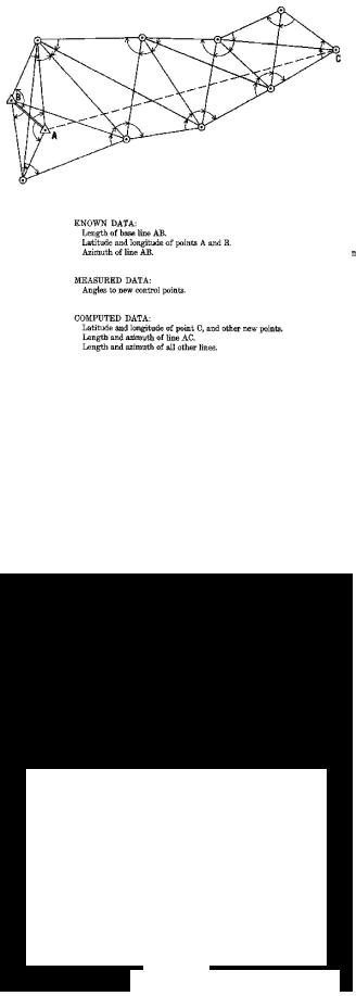
Basically, triangulation consists of the measurement of the angles of a series of triangles. The principle of triangulation is based on simple trigonometric procedures. If the distance along one side of a triangle and the angles at each end of the side are accurately measured, the other two sides and the remaining angle can be computed. Normally, all of the angles of every triangle are measured for the minimization of error and to furnish data for use in computing the precision of the measurements (Figure 7). Also, the latitude and longitude of one end of the measured side along with the length
and direction (azimuth) of the side provide sufficient data to compute the latitude and longitude of the other end of the side.
The measured side of the base triangle is called a base line. Measurements are made as carefully and accurately as possible with specially calibrated tapes or wires of invar, an alloy highly resistant to changes in length resulting from
changes in temperature. The tapes or wires are checked periodically against standard measures of length (at the Bureau of Standards in the United States and corresponding agencies in other countries). The geodimeter and tellurometer, operating on electro-optical and electronic principles respectively, have replaced the older methods of base measurement in the recent surveys. The work can be completed more rapidly and accurately than with wire or tape. The laser equipped geodimeter has proven to be the most accurate and it can measure much longer distances without
12