

A Dictionary of Archaeology
.pdfBurial Mound Period Term used in North American archaeology to refer to a chronological phase stretching from c.1000 BC to AD 700, which roughly corresponds to the WOODLAND period. The expression – rarely used now – first appeared in a synthesis of Eastern North American prehistory published by Ford and Willey in 1941. Later, Willey (1966) used the term as a period designator in An introduction to North American archaeology, subdividing it into two phases. Burial Mound I (1000 to 300 BC) included Tchefuncte, Deptford, Candy Creek and ADENA cultures, now classified as Early Woodland. Burial Mound II (300 BC–AD 700) included Marksville, HOPEWELL, and Weeden Island, now classified as Middle and/or Late Woodland. Cultural traits associated with the Burial Mound Period include pottery, burial mounds and agriculture (Stoltman 1978).
J. Stoltman: ‘Temporal models in prehistory: an example from eastern North America’, CA 19 (1978), 703–46; G. Willey: An introduction to American archaeology I: North and Middle America (Englewood Cliffs, 1966).
RJE
burin Multi-purpose blade tool, usually made of flint, which presents a gouging or chisel-like working edge formed by removing a distinctive flake or ‘burin spall’. Burins are one of the tool types that appear in the richer assemblages of the Upper Palaeolithic, helping to differentiate them from the Middle Palaeolithic.
burin spall see BURIN
burnishing Process of smoothing and polishing hardened, but not yet fired, clay vessels with a rounded tool such as a pebble or smooth bone. By compacting the clay, the permeability of the pot surface is reduced and a high shine (sometimes slightly facetted from the burnisher’s strokes) is produced. The term is distinct from ‘polish’, which should strictly be reserved for the buffing-up of pottery surfaces after firing.
RJA
Burushkhattum see AÇEMHÖYÜK
Burzahom Settlement and cemetery site in the Srinigar Valley of Kashmir, dating to the Kashmiri Neolithic of the 3rd millennium BC. Located by De Terra and Patterson in 1935, Burzahom was excavated by the Indian government from 1960 to 1971. Four chronological phases have been defined, ranging from the Neolithic (periods I–II) to the early historic period (IV: 324 BC–AD 347). The
BUSH BARROW 125
remains dating to Period I include pit-dwellings, handmade ceramics, ground stone axes and a wide array of bone and antler tools. Period II is characterized by mud-brick and wooden structures, one containing a stone slab engraved with a hunting scene, and many incorporating primary and secondary burials, some with dogs, wolves and ibex in association with human inhumations. In Period III a rough semi-circle of large standing stones was erected, and wheel-made pottery began to be used. Unfortunately, few indications of subsistence patterns have survived.
R.N. Kaw: ‘The Neolithic culture of Kashmir’, Essays in Indian protohistory, ed. D.P. Agrawal and D.K. Chakrabarti (New Delhi, 1979), 219–28; U. Sant:
Neolithic settlement pattern of northeastern and northern India (Delhi, 1991), 154–69.
CS
Bush Barrow (Wilsford G5) Bronze Age round barrow in Wiltshire, England, close to Stonehenge, which covered one of the richest burials of the WESSEX CULTURE. Dug into in 1808, the gravegoods included some of the finest and richest
Figure 9 Bush Barrow Grave goods from rich ‘Wessex’ tradition graves dating to the mid-2nd millennium BC at Bush Barrow, Wiltshire. Source:
T. Darvill: Prehistoric Britain (London, 1987), fig. 55a.
126 BUSH BARROW
examples of Bronze Age metalwork: sheet-gold ornamental lozenges finely incised with bands of lines; a gold belt-hook similarly incised; daggers (Armorico-British type) including one with a hilt decorated by hammering into it numerous tiny gold pins. The gravegoods also included a flanged axe, a polished stone macehead and ‘serrated’ bone mounts for a staff – often assumed to be a symbol of status of some kind. The staff mounts resemble grave-goods recovered from MYCENAE – though there are also parallels in gold objects found in Brittany – and have provoked continuing debate as to whether the Wessex elite responsible for Bush Barrow were in some sort of contact with the Mycenaean culture of the Mediterranean. However, while the Mycenaean material dates to around 1600 BC, the Bush barrow burial probably dates from a few centuries earlier.
S. Piggott: ‘The early Bronze Age in Wessex’, PPS 4 (1938), 52–106; J.J. Taylor: Bronze Age goldwork of the British Isles (Cambridge, 1980), 45; D.V. Clarke, et al.:
Symbols of power at the time of Stonehenge (Edinburgh, 1985); I.A. Kinnes et al.: ‘Bush Barrow gold’, Antiquity 62 (1988), 24–39.
RJA
Butmir Late Neolithic typesite, situated near Sarajevo, Bosnia, of the ‘Butmir culture’; the culture itself extends from the Middle Neolithic to Chalcolithic (5th and 4th millennium BC). Butmir culture vessels tend to be of a globular shape, elaborately decorated with the incised and painted (red and white) spiral and meander motifs; unlike the pottery of most contemporary cultures in southeast Europe paint was applied to ceramics after firing, rather than before. Butmir itself has provided a great number of figurines, the bodies of which tend to be quite crudely fashioned, while some of the heads are relatively naturalistic and full of expression. Phase II of the more recently excavated site of Obre, near Sarajevo, has provided significantly greater information about the development and settlements of the Butmir culture than the type-site itself.
M. Hoernes et al.: Die Neolithische Station von Butmir, 2 vols (Vienna, 1895, 1898); M. Gimbutas: The Goddesses and Gods of Old Europe (London, 1982).
RJA
Buto see FARAðIN, TELL EL-
Butser Ancient Farm Site of one of the first
major projects in EXPERIMENTAL ARCHAEOLOGY,
which was established in 1972 by Peter Reynolds in order to provide an experimental means of studying
the agriculture and domestic economy of the late Iron Age and early Roman period in Britain (c.400 BC–AD 300). Its overall objective was to create practical working research programmes based directly upon the archaeological evidence as interpreted from excavations. The design included the construction of a working farm, dating to c.300 BC and provided with appropriate livestock and plantstock, as well as a working Roman villa similarly fitted with all accoutrements.
During the period between 1972 and 1995 the Ancient Farm has actually occupied three locations. The first site, from which the farm draws its name, was a northerly spur of Butser Hill in the county of Hampshire; from 1976, a second site, with deeper soil cover, was developed in the valley bottom on Hillhampton Down on the southern slopes of Butser Hill. It was operated as a research site in conjunction with Little Butser, but it served primarily as an open-air museum and an educational resource for schoolchildren. On both of these sites the infrastructure comprised research fields, animal paddocks and an enclosure within which were built ‘constructs’ (see discussion in EXPERIMENTAL ARCHAEOLOGY) based upon specific archaeological data. The livestock maintained at the Ancient Farm comprised five breeds of sheep (Moufflon, Soay, Manx Loughtan, Hebridean and Shetland), Old English goats, Dexter cattle and Old English game fowl. Occasionally Tamworth pigs and European wild boars were also kept. The differing natures of the two sites allowed direct comparisons to be made between the two bioclimatic zones. However, at the beginning of 1991, both of these sites were vacated, and a new site developed at Bascomb Copse near Chalton, Hampshire, where the underlying geology (upper chalk with a loamy soil averaging 350 mm deep) offered an agricultural setting more typical of the chalk downlands of southern England.
P.J. Reynolds: Iron Age farm: the Butser experiment
(London, 1979); ––––: Ancient farming (Princes Risborough, 1987).
PRE
Byblos Syro-Palestinian coastal site (now in Lebanon), which was occupied from the Neolithic period onwards. The prosperous Bronze Age port had strong political and economic connections with pharaonic Egypt, to the extent that Egyptian hieroglyphs were sometimes employed. However, the site appears to have gone into a relative decline from the late 2nd millennium BC onwards (although the Iron Age PHOENICIAN city may lie beneath the modern town of Jubeil). The surviving remains of a nymphaeum, temple and theatre suggest that Byblos
was still of some importance during the time of the Roman empire.
P. Montet: Byblos et l’Egypte, 2 vols (Paris, 1928); M. Dunand: Fouilles de Byblos (Paris, 1939–58); J.-F. Salles:
La nécropole “k” de Byblos (Paris, 1980).
IS
Bylany One of the principal early (1953–4) excavations of a Linearbandkeramik or LBK culture
BYLANY 127
site, this early farming settlement near Prague in central Bohemia in the Czech Republic consisted of longhouses (up to 45 m in length) built of posts, with possible grain stores and pits. The economy was based upon emmer wheat and the raising of cattle. See LINEARBANDKERAMIK for further discussion and bibliography.
RJA

C
14C see RADIOCARBON DATING
Caban see CHAM
cacao The pod-like fruits of the cacao tree (Theobroma cacao) contain large oval seeds, which the pre-hispanic inhabitants of Mesoamerica ground into a powder and mixed with water and chiles – and/or honey and maize gruel – to create a beverage. Cacao seeds or beans were also used as a medium of exchange by the Aztecs and perhaps by earlier Mesoamerican societies. The pods and seeds often appear as decorative motifs on pottery and other art; residue analysis has confirmed the presence of cacao in a ceramic vessel found in an Early Classic (c.AD 200–600) burial at the LOWLAND MAYA site of Río Azul. Cacao trees were cultivated in limited areas of rich, fertile lowland soils.
J.E.S. Thompson: ‘Notes on the use of cacao in Middle America’, Notes on Middle American Archaeology and Ethnology 128 (1956), 95–116; D. Stuart: ‘The Rio-Azul cacao pot: epigraphic observations on the function of a Maya ceramic vessel’, Antiquity 62 (1988), 153–7; A. Gómez-Pompa et al.: ‘The sacred cacao groves of the Maya’, LAA 1 (1990), 247–57.
PRI
Cacaxtla Fortified site in southwest Tlaxcala, Mexico, dating to the 8th–10th centuries AD, known for its mural paintings. The style and content of the paintings are similar to those of the lowland Maya site of BONAMPAK; they depict a battle scene between elaborately attired (and vanquished) lowland Maya(?) and victorious highland (Teotihuacano?) peoples, as well as winged images of patron deities.
M. Foncerrada de Molina: ‘Mural painting in Cacaxtla and Teotihuacán cosmopolitanism’, Third Palenque Round Table, 1978, Part 2, ed. M.G. Robertson (Austin, 1980), 183–98.
PRI
Cahokia Major MISSISSIPPIAN ‘mound center’ located in the Mississippi River floodplain in
Illinois, eastern North America. The site covered 13 sq. km and consisted of residential areas, plazas and over 100 mounds, widely scattered over bottomland ridges, with the most heavily occupied areas located on high ground alongside an abandoned river channel. The central focus of the site is a large, rectangular plaza surrounded by mounds, including Monks Mound, the largest prehistoric mound in the United States. Cahokia was occupied for many hundreds of years, rising to regional prominence in about AD 1000. The site and surrounding region were virtually abandoned by 1400.
M.L. Fowler: The Cahokia atlas (Springfield 1989); G.R. Milner: ‘The late prehistoric Cahokia cultural system of the Mississippi River valley: foundations, fluorescence, and fragmentation’, JWP 4 (1990), 1–43.
GM
Cahuachi The largest known site of the Nazca culture, situated in the Nazca Valley, Peru, and dating to the Early Intermediate Period (c.400 BC–AD 500). It consists of a large number of large platforms, built on cores of existing hills, with associated walled spaces. Cahuachi was a pilgrimage centre, uninhabited for much of the time but connected by geoglyphs across the high desert with the urban ‘Site 165’. Comparisons to modern pilgrimage patterns and Andean concepts of space suggest that Cahuachi and Site 165 may have been lower and upper (hatun and hurin). Cahuachi is associated with strange-shaped hills, later modified into platforms and walled areas for temporary occupation, perennial water sources, and with an echoing phenomenon, being the sacred half of the dual organization typical of Andean sociopolitical constructs.
H. Silverman: Cahuachi in the ancient Nasca world (Ames, 1993).
KB
Caihouluan see TS’AI HOU LUAN
caitya Structure built to house a sacred Buddhist relic, such as a notable image of the Buddha.
calcite banding Layers in stalagmitic calcite giving luminescence due to humic and fulvic acids derived from soil. These layers appear to be annual and thus could provide a high resolution climatic indicator (e.g. calcite growth is rainfall-dependent and stable isotope analysis provides temperature information).
A. Baker et al.: ‘Annual growth banding in a cave stalagmite’, Nature 364 (1993), 518–20.
SB
calcium-41 dating see RADIOCALCIUM
DATING
calendars, Mesoamerican Mesoamerican peoples recorded time and history by means of several calendars that counted days and also multiples of days roughly analogous to months, years and larger units of time. Two primary calendars were in use throughout Mesoamerica and both recorded cycles of time by day or month names and numbers. One was a very ancient calendar, known to the AZTECS as Tonalpohualli, which was composed of 20 day names or signs prefixed by a number from 1 to 13 (e.g. 5 Cimi or 9 Xochitl). The same names and numbers coincided every 260 days. The other was a 365-day calendar, approximating our solar year, which consisted of 18 named ‘months’ of 20 days each, counted from 0 to 19 (as 0 Pop, 1 Pop, 2 Pop, etc.); the last five days of the year (known as Uayeb among the Maya and Nemontemi among the Aztecs) were considered unlucky. Most Mesoamerican peoples used both calendars simultaneously to record time. The Maya, for example, recorded time on their STELAE by means of the simultaneous cycling of the two calendars and also by use of the ‘long count’ (itself an absolute method of recording time from a given starting date, rather than a calendar).
The cycling of the two calendars defined another important interval of time for Mesoamerican peoples. For any particular numbered day in the 260-day calendar to coincide with any particular day and month in the 365-day calendar, the calendars had to cycle through 18,980 days, or 52 years. The beginning and ending of this 52-year cycle, known by archaeologists as the ‘Calendar Round’, was celebrated widely throughout Mesoamerica, as, for example, in the Aztec new fire ceremony.
M.S. Edmonson: The book of the year: Middle American calendrical systems (Salt Lake City, 1989); M.E. Miller and K. Taube: The gods and symbols of ancient Mexico and the Maya: an illustrated dictionary of Mesoamerican religion
(London, 1993), 48–54.
PRI
CANAANITES
Calico Hills Controversial lithic site located in an alluvial fan deposit in southeastern California. Assemblages consist of surface finds and flaked objects excavated from a depth of over 5 m. Bifaces found on the surface are part of the Manix Lake complex and are clearly artefactual. The subsurface finds consist of thousands of pieces of flaked chert, some of which resemble struck flakes and simple stone tools. These few objects are a highly selected sample sorted by archaeologists from thousands of pieces of fractured chert and are considered by many archaeologists to be GEOFACTS. This has led to investigations of how to differentiate quarry debris from early primitive industries (Glennan 1976: 43–61) and distinguish pseudoartefacts produced by natural forces from real artefacts (Haynes, 1973). Dates range from 500,000 BP, based on the geology (Haynes 1973), to about 80,000–125,000 BP for the site surface and 200,000 BP at its base, determined by uranium-thorium
assays of CaCO3 (see URANIUM-SERIES DATING).
C.V. Haynes: ‘The Calico site: artefacts or geofacts?’, Science 181 (1973), 305–10; W.S. Glennan: ‘The Manix Lake lithic industry: early lithic tradition or workshop refuse?’ Journal of New World Archaeology 1 (1976), 43–62; W.C. Schuiling, ed.: Pleistocene man at Calico (Redlands, 1979).
RC
Calima Region of southwestern Colombia with a long cultural tradition (c.1000 BC –Conquest; see AMERICA 6) beginning with the Ilama Phase (Early Calima, 1st millennium BC), whose finely incised and painted ceramics and hammered gold work show an elaborate development of shamanistic beliefs, the ritual use of coca, and an appreciation of the animal life around them. Ilama is ancestral to Yotoco (Calima, AD 100–7/1100)), known for its large hammered gold ornaments. These can now be related to distinctive modelled and organic resistpainted pottery as well as habitation sites consisting of series of artificial terraces which had rectangular houses on them. The Calima culture was also characterized by large-scale drained field and road systems, and the burial of the dead in shaft-and- chamber tombs. A terminal pre-Conquest phase, Sonso, has also been identified.
M. Cardale de Schrimpff et al.: Calima: trois cultures précolombiennes dans le sud-oueste de la Colombie (Lausanne, 1991).
KB
Canaanites Term used to describe the people occupying Palestine and southwestern Syria from at least the beginning of the Middle Bronze Age
130 CANAANITES
(c.2000 BC) onwards. The geographical term Canaan is much easier to define than the cultural or ethnic traits of its Bronze Age inhabitants. Numerous Egyptian and Mesopotamian texts refer to the Canaanites from the 15th century BC onwards and the beginning of the Iron Age (c.750 BC) is usually considered to represent the end of the Canaanite culture, but there are major problems in attempting either to assess the origins of the Canaanites or to correlate the written references with archaeological sites. Kenyon (1966) argued that the Canaanites emerged during the period of AMORITE incursions into Syria-Palestine at the end of the 3rd millennium BC, and were in fact ‘urbanized Amorites’, whereas Millard (1973: 38) suggests that the situation was much more complex: ‘Palestine received a motley array of peoples and influences. Should the amalgam be designated Canaanite? . . . If the name was used by the natives of the area, then either they survived the various invasions, retaining some sense of identity . . . or the name was assumed by their conquerors, or simply applied to any denizens or products of the region.’
If the term is taken to refer simply to the inhabitants of Palestine in the 2nd and early 1st millennia BC then the major Canaanite cities would include Hazor, BETH SHAN and MEGIDDO. Canaanite personal names in the AMARNA letters and the UGARIT archives suggest that the population was a mixture of Semites, Hurrians and Indo-Europeans. In c.1600 BC the West-Semitic speaking Canaanites began to write texts using an alphabet of 32 letters, which was perhaps derived partly from the Egyptian HIERATIC script. The Canaanite alphabet evolved into the PHOENICIAN script and was eventually to form the basis for the Greek, Hebrew and Arabian alphabets.
T. Bauer: Die Ostkanaanäer (Leipzig, 1926); J. Gray: The Canaanites (London, 1964); K. Kenyon: Amorites and Canaanites (Oxford, 1996); A.R. Millard: ‘The Canaanites’, Peoples of Old Testament times, ed. D.J. Wiseman (Oxford, 1973), 29–52.
IS
Can Hasan see ACERAMIC NEOLITHIC
canonical variates analysis see
DISCRIMINANT ANALYSIS
canopic jar Egyptian stone or ceramic funerary vessel containing the entrails extracted from a mummified body; four canopic jars were commonly placed in the tomb alongside the sarcophagus. The shapes of the lids of the four jars developed from a basic convex form in the Old Kingdom
(c.2649–2150 BC) to a human head in the Middle Kingdom (c.2040–1640 BC). From the 19th dynasty (c.1307–1196 BC) onwards the lids took the form of the heads of the mythical Sons of Horus. The last surviving set of royal canopic equipment was made for the Late Period ruler Apries (589–570 BC). The term ‘canopic’ (an Egyptological term derived from the misconception that human-headed jars were worshipped at the town of Canopus in the Egyptian Delta) was also applied to a type of Etruscan cinerary urn in the form of a sculpture of the deceased, the head serving as the lid and the arms as the handles. Many Etruscan canopics were found at the Italian site of Clusium and date to between the 6th and 3rd centuries BC.
R. Gempeler: Die Etruskischen Kanopen (Einsiedeln, 1974); C. Dolzani: Vasi Canopi (Milan, 1982); A. Dodson:
The canopic equipment of the kings of Egypt (London, 1994).
IS
Cape Gelidonya see GELIDONYA
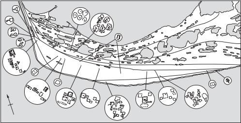
Cape Krusenstern One of the richest site localities in the North American Arctic, located on Kotzebue Sound, Alaska. Here, clearly separated by an impressive horizontal stratigraphy produced by the accumulation over thousands of years of 114 separate beach ridges (see map 19), there are remains deriving from the Denbigh Flint complex, Old Whaling, Choris, NORTON TRADITION, IPIUTAK, Birnirk, THULE and more recent occupations.
J.L. Giddings: Ancient men of the Arctic (New York, 1967);
–––– and D.D. Anderson: Beach ridge archaeology of Cape Krusenstern (Washington, 1986).
RP
Capéletti Cave at an altitude of 1580 m above sea level on the northern slopes of the Aurès mountains south of Constantine in northeastern Algeria. It was excavated by Colette Roubet in 1968, and four distinct occupation horizons attributed to the ‘Neolithic of Capsian Tradition’ have produced 7 radiocarbon dates ranging from 6530 to 4340 BP. The mammalian fauna is dominated by domestic sheep and/or goat which account for 70–90% of the identified bones and which must have been introduced into the area. Bovids are important in the uppermost horizon only, where their bones constitute 25% of the total. According to Achilles Gautier, it is not completely clear whether they were domesticated or not. In Roubert’s interpretation, the inhabitants (who also relied on seasonal collection of plant resources and land snails) practised a ‘pastoral, pre-agricultural’ transhumant
CAP MANUEL 131
Recent |
Old Whaling (summer) |
|
|
|
|
|
|
|
|
||
Recent |
Old Whaling (winter) |
Lagoon |
|
||
|
|
|
|||
|
|
|
|
||
|
|
Early Ipiutak |
|
|
|
Birnirk |
|
|
|
|
|
Recent |
|
|
|
|
|
Ipiutak |
Ipiutak |
|
|
|
|
|
|
|
|
Recent |
|
N |
|
|
|
Ipiutak |
|
|
|
|
|
||
Ipiutak |
|
|
|
Ipiutak |
|
Ipiutak |
Ipiutak |
Ipiutak |
|||
Late Western Thule |
|||||
|
|
||||
|
Early Western Thule |
|
|
Chukchi Sea |
|
Map 19 Cape Krusenstern Plan of Cape Krusenstern, showing excavated settlements from various periods (after J.L. Giddings and D.D. Anderson: Beach ridge archaeology of Cape Krusenstern (Washington, D.C., 1986), fig. 6).
economy, retreating to the lower slopes during the winter. It is suggested that the system of animal husbandry in force until recently among the Berbers of the area differed little from that of their Neolithic predecessors
C. Roubet: ‘Une économie pastorale, pré-agricole en Algérie orientale: le néolithique de tradition Capsienne’, L’Anthropologie 82 (1978), 583–6; –––– and P.L. Carter: ‘La domestication au Maghreb: état de la question’, Origin and early development of food-producing cultures in northeastern Africa, ed. L. Krzyzaniak and M. Kobusiewicz (Poznan, 1984), 437–51; A. Gautier: ‘Prehistoric men and cattle in North Africa: a dearth of data and a surfeit of models’, Prehistory of arid North Africa, ed. A.E. Close (Dallas, 1987), 163–87.
PA-J
Cap Manuel Stone workshop site at the southern extremity of the Cape Verde peninsula, on a promontory within the city of Dakar, Senegal; discovered in 1942 and excavated by C. Descamps in 1967–8. The site is on the eastern sheltered side of the promontory; the numerous finds are concentrated over an area up to 100 m from the shore at the foot of a 30 m cliff of ankaratrite, the volcanic rock of which the promontory consists. The stratigraphy and chronology of the site were established principally by means of a 6 m² trench excavated to a depth of 2.80 m starting at a point 3.50 m above sea level. Beneath recent colluvial and storm beach deposits, layer III contained traces of a shell midden
with some rolled artefacts; in situ archaeological material was found in layer II amid large ankaratrite boulders, which also constituted the basal beach deposit. The great majority of the industry is made of ankaratrite, and because of the presence of a number of bifacially worked tools it was in the past variously classified by different authors as either ‘Toumbian’ or ‘Sangoan’. Descamps eliminated many misunderstandings by his careful study of these artefacts, establishing their characteristic breakage patterns by refitting, and lumping them all together as one broad category (‘pièces allongées’). These and what he termed pushplanes (‘rabots’) made up the great majority of the retouched tools; but the context and significance of this industry were made much clearer by the other elements found in situ in layer II, including one polished stone axe and 130 fragments of potsherds, as well as a number of fishbones (some of them in anatomical connection). He therefore unambiguously defined the industry as a specialized facies of the Neolithic. A terminus ante quem was provided by two radiocarbon dates on shells from layer III of 2880 ± 80 and 2839 ± 127 BP, and by relying on the radiocarbon dates from AMEKNI to provide a maximum starting point, Descamps considered that the site most probably dated to a period between 4000 and 8000 BP. As a hypothesis he suggested that the tools were used for woodworking and that – since the use of boats is indicated not only by the fishbones but also by the presence of similar artefacts on the Ile
132 CAP MANUEL
aux Serpents, 4 km out to sea – the site served as a kind of ‘naval dockyard’. This explanation, however, could not apply to Diack, a site otherwise very similar to Cap Manuel, but lying well inland 30 km east of Thiès.
C. Descamps: Contribution à la préhistoire de l’ouest Sénégalais (Dakar, 1979).
PA-J
Capsian Palaeolithic industry, named by Jacques de Morgan in 1909 after the town of Gafsa in southern Tunisia, and with a chronological range of c.10,000–6,500 BP. Generally regarded as ‘EPIPALAEOLITHIC’, it is conventionally divided into two units: Typical and Upper Capsian; both have backed bladelets, but the Typical Capsian has a heavier component including large numbers of burins, and the Upper Capsian a lighter component including geometric microliths of various kinds.
Geographically, the Capsian is concentrated on the High Constantine Plains of northeastern Algeria and in adjacent parts of Tunisia. The technology and typology of this industry have been intensively studied since its first identification, and successive models have been proposed to chart its development: at first a unilinear scheme proposed by Raymond Vaufrey in 1935, then a binary scheme in which the Capsian was seen to develop in parallel with the IBEROMAURUSIAN proposed by Lionel Balout in 1955, and then a scheme inspired by the concept of ‘branching evolution’ espoused by Gabriel Camps in 1974. In all these schemes, the Capsian led on to a ‘Neolithic of Capsian Tradition’ as at CAPÉLETTI. All were rejected on epistemological grounds by David Lubell and his colleagues, who recognize instead two major ‘regional traditions’ in the eastern and western parts of the Maghreb, both developing from the Iberomaurusian and therefore not intrusive to the area. The Capsian is particularly well known for its open-air sites, in which land snails form a prominent part of the occupational debris, often referred to as ‘escargotières’. One such site was partially excavated by Lubell and his colleagues at Ain Misteheyia southwest of Tébessa in eastern Algeria, as a result of which he estimated that snails in fact accounted for probably no more than one sixth of the animal protein consumed. The majority was provided by large vertebrates such as horse, gazelle, aurochs, and hartebeest. A general pattern of rotating settlement was discerned, with intermittent residency at any one site, and the likely Capsian diet is described as ‘a stew containing meat, snails, and some plants, perhaps accompa-
nied by a gruel made from boiled grasses, garnished with nuts, and perhaps seasoned with wild herbs and shallots’ (Lubell et al. 1976: 919). According to Chamla, 24 individuals have so far been found in eastern Algerian Capsian contexts, of which 10 are of MECHTA-AFALOU and 14 of ‘ProtoMediterranean’ type, the latter being regarded as immigrant. This scenario is disputed by Lubell and his colleagues, who emphasize population continuity in this area and therefore development in situ from the Iberomaurusian onwards. See also
KENYA CAPSIAN.
G. Camps: Les civilizations préhistoriques de l’Afrique du Nord et du Sahara (Paris, 1974); D. Lubell et al.: ‘The Capsian escargotières’, Science 191 (1976), 910–20; M.C. Chamla: ‘Le peuplement de l’Afrique du Nord de l’épipaléolithique à l’époque actuelle’, L’Anthropologie 82 (1978), 385–430; D. Lubell et al.: ‘Continuity in the Epipaleolithic of Northern Africa with emphasis on the Maghreb’. AWA 3 (1984), 143–91.
PA-J
carbon isotope analysis Carbon exists in three isotopes of which two, 12C and 13C, are stable; the latter has a natural abundance of about 1%. Variations in the abundances of these, and other, light element stable isotopes can arise through physical and chemical factors which fractionate between lighter and heavier isotopes leading to changes in the isotopic ratio. The ratio (13C/12C) is usually measured by gas source mass spectrometry on samples converted to carbon dioxide. Results are expressed in the form δ13C, which is the difference in the ratio in ‘parts per mil’ (parts per thousand) from the carbonate reference material Pee Dee belemnite (PDB, ratio 0.0112372). The δ13C value may be positive, enriched in 13C relative to the reference, or negative, depleted in 13C.
The δ13C value of archaeological material is of interest for several reasons. It is, for example, essential to measure the 13C/12C ratio of radiocarbon samples in order to correct for the likely natural fractionation of 14C relative to 12C (see CARBON DATING). The δ13C value is also used, in conjunction with that of δ18O (OXYGEN ISOTOPE ANALYSIS), as a means of characterizing and provenancing carbonates, particularly the marble used for Classical sculpture and building construction. Carbon isotopes are also exploited in studies of ancient diet because the fractionation effects of the two plant photosynthesis pathways, C3 and C4, lead to differences in δ13C value. Herbivores take on a δ13C value related to the plant groups consumed and thus their dietary source may be deduced. This approach has been used, for example, to show the
spread in consumption of maize (a C4 plant) through parts of North America in areas where consumption of C3 plants had previously predominated.
N. Herz and M. Waelkens: Classical marble: geochemistry, technology, trade (Dordrecht, 1988); N.J. van der Merwe: ‘Light stable isotopes and the reconstruction of prehistoric diets’, New developments in archaeological science, ed. A.M. Pollard (Oxford, 1992), 247–64.
MC
Carchemish (Djerablus) City in northern Syria, 125 km northeast of Aleppo, located at a crucial crossing-point on the Euphrates. Occupied from the Neolithic period until the Roman empire, it prospered particularly during the Bronze Age, both as a major HITTITE town during the Old Kingdom and Empire (c.1680–1205) and as an important post-Hittite centre in the 1st millennium BC, with impressive fortifications similar to those at the contemporary (though slightly larger) site of ZINJIRLI. The post-Hittite phase of the site is characterized by a considerable number of sculpted basalt reliefs carved with Hittite hieroglyphs, as well as rare examples of neo-Hittite statuary, which were excavated by Leonard Woolley.
D.G. Hogarth et al.: Carchemish, 3 vols (London, 1914–52); H.G. Güterbock: ‘Carchemish’, JNES 13 (1954), 102–14; M.E.L. Mallowan: ‘Carchemish: reflections on the chronology of the sculpture’, AS 22 (1972), 63–85.
IS
cardial ware Form of impressed ware that comprises the earliest type of pottery (7th–5th millennium BC) in the coastal regions of the central and west Mediterranean. Cardial ware vessels are decorated by pressing the serrated edge of the Cardium shell into the clay. Cardial ware is found in Liguria (e.g. ARENE CANDIDE), southern France, Spain, Sardinia and Corsica. A few examples of cardial ware are now known from west-central France (Charente-Maritime), outside the Mediterranean region. Early cardial ware may have functioned as a prestige object in exchange – a suggestion supported by the fact that in many contexts the earliest cardial ware is noticeably finer than the later cardial ware (the so-called ‘epicardial ware’).
RJA
carination Term used to describe the angle formed when the surface of a pottery vessel changes direction, usually forming a shoulder or creating a distinct rim. The use, placing and angle of
CARNAC REGION 133
carination help to give many pots their distinctive profile, and it is thus an important visual identifier in pottery classification.
RJA
Carmel see MOUNT CARMEL
Carnac region Neolithic funerary and megalithic ceremonial complex, including the largest set of ALIGNMENTS in the world, situated near the town of Carnac in Morbihan, Brittany. Near the hamlet of Le Menec, 11 rows of stones lead away from a large oval ring of stones. Close by are the Kermario alignments (seven main rows of over 1000 stones), which are associated with a large earth mound originally topped with a standing stone. The nearby Kerlescan alignments (13 rows of c.540 stones) are associated with an arrangement of megaliths in a rounded square. The smaller alignments at Petit Menec, a walk away, contain about 100 stones.
Despite clumsy restoration in the 19th century, the Carnac alignments share a number of features: they seem not to have been intended as straight lines (as a whole the rows curve gently and some individual lines wander badly); the gaps between the rows tend to be wider in the middle of the lines; the heights of the megaliths become lower as one walks along them, and then may rise again at the end. It also seems likely that at least the Le Menec and Kermario alignments originally had rings of megaliths at both ends. There has been an attempt by Thom and others (Thom and Thom 1971, 1972) to prove that the alignments have an astronomical significance. While there is evidence for concern with the major solar events, and possibly some major lunar events, claims that the alignments contain sophisticated astronomical alignments and subtle geometry are not yet generally accepted by archaeologists.
The Carnac area also boasts huge, early standing stones – notably the fallen Grand Menhir Brisé at Locmariaquer (originally Europe’s tallest menhir, at over 20 m). There are also a series of distinctive long mounds known as ‘Carnac mounds’ (e.g. Er Grah, 120m long with megalithic chamber) that contain particularly rich grave goods, notably the jadeite polished stone axes found within the massive Tumulus de Saint-Michel. In terms of relative chronology, the Carnac mounds and large standing stones seem to be the earliest major monuments in the Carnac region (late 5th millennium onwards), the passage graves rather later (late 4th millennium onwards), while the major alignments seem to date from the 3rd millennium.
134 CARNAC REGION
A. Thom and A.S. Thom: Journal for History of Astronomy
II (1971), 147; III (1972), 11, 151; P.R. Giot et al.:
Préhistoire de la Bretagne (Rennes, 1979); D. Heggie: Megalithic science (London, 1981); A. Burl: From Carnac to Callanish (London, 1993).
RJA
‘cart burials’ see KISH
Carter Ranch Pueblo Pueblo of 39 rooms located in the Hay Hollow Valley, east-central Arizona, occupied between AD 1100 and 1225. Domestic rooms were built of stone masonry around a plaza containing a D-shaped kiva. A detached circular great kiva was located 10 m northwest of the PUEBLO.
The birth of processual archaeology. Carter Ranch Pueblo was excavated by Paul S. Martin and John B. Rinaldo of the Southwest Expedition of the Chicago Field Museum of Natural History, and the ceramics were analysed by W.A. Longacre, effectively marking the beginning of contemporary American archaeological research into social organization. During this critical time, Lewis R. Binford arrived at the University of Chicago to fuse additional theoretical and methodological elements, especially an ecological focus, with indigenous sociological concerns to form the initial paradigmatic
statement of PROCESSUAL ARCHAEOLOGY.
The University of Chicago had long been a bastion of social anthropology, and in the late 1940s Paul Martin and John Rinaldo were inspired by Fred Eggan’s seminar on social structures to speculate on features of prehistoric social organization in Sites of the Reserve phase, Pine Lawn Valley, western New Mexico (Martin and Rinaldo 1950). George Peter Murdock’s Social structure and Fred Eggan’s Social organization of the western pueblos, published in 1949 and 1950 respectively, provided comparative and historical support to archaeological investigations in the American Southwest. During the 1950s, Martin directed his interest in social organization into settlement pattern research, which was the prevailing analytical problem of the period (see SPATIAL ANALYSIS). Together, Paul Martin and the University of Chicago team laid the foundations for the emergence of processual archaeology.
In 1959, William Longacre was hired by Martin to conduct an archaeological survey in east-central Arizona during the summer, and that autumn he became a graduate student in the Department of Social Anthropology at the University of Chicago. In the following year he continued his survey work. During the 1960–1 academic year, Constance
Cronin, another social anthropology graduate student, analysed black-on-white ceramics from a number of sites investigated by Martin, discovering that design elements of different pottery types at a single site were more similar than the design elements on the same type at different sites. The implications for the transmission of design information – and thus for the inferring of features of social organization – were immediately apparent.
The first season of excavation at Carter Ranch, in the summer of 1961, was designed to test the proposition that analysis of ceramic decoration could provide access to prehistoric social organization. It was afterwards, in the autumn of 1961, that Lewis Binford joined the Chicago faculty. The 1962 season at Carter Ranch clearly shows Binford’s influence on fieldwork in the use of SAMPLING STRATEGIES and in the investigation of room function.
Proceeding from Cronin’s original insight, Longacre interpreted the spatial clustering of ceramic design elements in different sections of the pueblo as an indication of the localization of female potters maintained over several generations by matrilocal residence and matrilineal descent. His doctoral dissertation (Archaeology as anthropology: a case study), which was presented in 1963 and published in 1970, embodies Martin’s long-term interest in social organization and Binford’s theoretical concerns; its methodological flaws, such as the assumption that pots were locally made and Longacre’s general inattention to SITE FORMATION PROCESSES, were to characterize processual archaeology as a whole.
The component of processual archaeology relating to social organization was thus nurtured by Paul Martin in the laboratories of the University of Chicago and the Field Museum, as well as in the prehistoric sites of the American Southwest such as Carter Ranch.
G.P. Murdock: Social structure (New York, 1949); F. Eggan: Social organization of the Western Pueblos (Chicago, 1950); P.S. Martin and J.B. Rinaldo: Sites of the Reserve Phase (Chicago, 1950); L.R. Binford: ‘Archaeology as anthropology’, AA 28 (1962), 217–25; W.A. Longacre:
Archaeology as anthropology: a case study (Tucson, 1970).
JJR
Carthage see AFRICA 1
Casa Grande Late Classic period HOHOKAM site on the Gila River near Coolidge, Arizona, dating to c.AD 1300–1400, which was visited by Father Eusebio Kino in 1694. It contains the only extant Hohokam ‘big house’: a four-storey adobe