

A Dictionary of Archaeology
.pdf4.1. The Middle and Later Stone Ages. Southern African archaeologists distinguish two very generalized stone-working traditions within the last 150–200,000 years. The older of these, the Middle Stone Age (MSA), is characterized by the production of flakes and flake-blades, some of them retouched to form scrapers, knives, points or backed pieces. Prepared core technology is not as strongly developed a feature as it is of roughly contemporary Middle Palaeolithic technologies, but many flakes and flake-blades do have faceted platforms; true Levallois cores sometimes occur.
Although some regional industries have been identified (e.g. the Orangian Industry on South Africa’s central plateau) detailed classification of Middle Stone Age assemblages is generally avoided: there are few long sequence sites and chronological controls, especially for open-air locations, are poor. Instead, four broadly successive stages are recognised. Dated by reference to the global oxygen isotope stage curve, they are: MSA 1 (stage 6); MSA 2 (stages 5e–5b, the Last Interglacial); the HOWIESON’S POORT (stages 5a/4); MSA 3 (stage 3). Within these stages assemblages vary widely in artefact morphology, core types and raw material. In broad terms the MSA 1 has very few retouched pieces with points completely absent; the MSA 2 features relatively large flake-blades, as well as scrapers and both unifacial and bifacial points (including those previously known as STILLBAY); the Howieson’s Poort shows enhanced use of finegrained rocks and includes high frequencies of segments and other backed pieces, some of microlithic proportions; and the MSA 3 is highly variable, but clearly post-Howieson’s Poort in age. While MSA 1 assemblages may have been produced by archaic hominids, anatomically modern human fossils have been found with more recent MSA assemblages at several sites in South Africa. However, still at issue is the extent to which this physical modernity necessarily implies similarities in cultural behaviour and potential, with unequivocal evidence for art and jewellery, for example, only
found (e.g. at APOLLO 11 CAVE and BORDER CAVE
respectively) after 40,000 BP.
For a long time debate has persisted on the date of the transition between Middle and Later Stone Age (LSA) technologies, but an emerging consensus, based on data from sites such as BOOMPLAAS,
ROSE COTTAGE CAVE and SEHONGHONG, now
locates this for the area south of the Limpopo to around 21,000 BP. Characteristic of most LSA assemblages is an emphasis on the production of microliths, but more significant in a behavioural sense are similarities with the material culture
AFRICA 25
used by recent southern African hunter-gatherers. Examples found already in Pleistocene LSA contexts include ostrich eggshell and bone beads, bored stone digging stick weights, tortoiseshell bowls, ostrich eggshell containers (sometimes decorated with incised geometric designs) and bone (arrow?) points. Such similarities encourage archaeologists in their use of ethnographic data to interpret the archaeological record, though with a growing recognition of the value of looking beyond southern Africa for appropriate analogies.
Four or five broadly successive artefact traditions are generally recognized within the southern African Later Stone Age. Although the very earliest LSA assemblages are amorphous, quartzdominated microlithic occurrences, between 19,000 and 12,000 BP the systematic production of unretouched bladelets from highly distinctive bladelet cores distinguishes Robberg assemblages, which are found across South Africa, Lesotho and Swaziland. These bladelets were used in a diverse range of tasks as the cutting edges of composite artefacts; those formally retouched tools (scrapers, adzes, backed microliths) that do occur are always rare. Broadly contemporary with the Robberg, the Maleme Industry of southwestern Zimbabwe retains some MSA features, while macrolithic assemblages are found at sites in Namibia.
Very different assemblages are found across the Pleistocene/Holocene boundary. Dating to roughly 12–8000 BP they are grouped within the OAKHURST Complex and cover a much wider area than the Robberg, extending north of the Limpopo to include sites in Zimbabwe and Namibia. Several regional industries are recognized, largely from differences in raw material usage: Kuruman in the Northern Cape Province, Lockshoek across much of South Africa’s interior plateau, ALBANY in the Cape Fold Mountains and their adjacent coastlands, Pomongwan in Zimbabwe. The Oakhurst differs from the Robberg in that bladelets are extremely rare, coarser-grained rocks tend to be preferred and flakes and scrapers (virtually the only retouched tools) are larger. Much higher numbers of beads, other ornaments and bone tools are also found after 12,000 BP, perhaps signalling an increased role for exchange as a means of minimizing ecological risk and/or a transformation in social relations.
Zambia, Malawi and northern Zimbabwe fall into a different cultural province from the rest of the subcontinent. MSA assemblages, well documented at sites such as Mumbwa Cave, were replaced by 19,000 BP by microlithic traditions known locally as Nachikufan. Though similar to the Robberg in
26 AFRICA
having evidence of bored stones, worked bone and jewellery, the Nachikufan is typified by the production of backed (as opposed to unmodified) bladelets and points. Once established this pattern of artefact manufacture also shows more continuity than is evident further south; there is no Zambian or Malawian equivalent of the Oakhurst Complex and Nachikufan-like assemblages continued to be produced in some areas, such as western Zambia, until recent centuries.
Beginning around 9500 years ago in Namibia and Zimbabwe, but occurring only from 8000 BP south of the Limpopo, a different technological tradition is found. This WILTON complex marks a return to a microlithic technology, but is only superficially similar to the Robberg. Both made extensive use of fine-grained rocks, but the Wilton was not a bladelet technology. Instead, it was geared to the systematic manufacture of a wide range of scrapers and backed microliths (especially segments in its earlier stages) generally made on small flakes. Microwear shows that scrapers were used to work skins, but perhaps mostly in finer, decorative work, with backed microliths used in a variety of cutting tasks as knives, and perhaps also as arrow armatures.
Holocene microlithic assemblages continued to be made in many parts of southern Africa until the nineteenth century, though with changes in the details of scraper design and the kinds of backed microliths produced. A general trend in many areas is for the frequency of adzes (widely interpreted as woodworking implements) to increase during the last 4000 years, a pattern linked in the Thukela Basin of KwaZulu-Natal and elsewhere to increased use of underground plant foods, for the exploitation of which wooden digging sticks would have been needed. Comparable developments are also observable in other parts of the subcontinent and may be linked to the development of more elaborate burials (as a means of establishing claims to local landscapes) and greater use of other small-sized food resources, such as fish, shellfish and ground game. At the same time the archaeological record exhibits an increasing regionalization of material culture, although only rarely is this formally recognized in archaeological nomenclature. One of the best examples of this regionalization is the distribution of pressure-flaked stone arrowheads and backed microliths across Lesotho, the Free State and the eastern Karoo: recent studies suggest this at least partly correlates with ostrich eggshell and seashell bead exchange networks and with the distribution of rock-paintings of fish belonging to the mormyrid family.
Despite growing social and economic complexity in some parts of the subcontinent, there is no evidence that any of the plant or animal resources indigenous to southern Africa were independently domesticated. However, for much of the last 2000 years the region’s hunter-gatherers have been in close contact with food-producing societies. In the southwestern part of the sub-continent these contacts were with Khoi-speaking pastoralists, whose linguistic affiliations suggest an ultimate origin in north-central Botswana; sheep were presumably acquired here originally from Iron Age farmers. Recent accelerator dates show sheep present in the Cape Fold Belt c.1900 BP, though associations with the local introduction of pottery are not clearcut. As with recent dates suggesting that pottery appeared in southeastern southern Africa several hundred years before the oldest known Iron Age villages, this raises the possibility that ceramics were adopted ahead of, or by different means from, the local establishment of food-producing communities and encourages archaeologists to consider the active roles played by hunter-gatherers in the development of pastoralist and farming societies.
Side by side with pastoralists and Iron Age farmers, hunter-gatherer populations survived across most of southern Africa well into the colonial era, in some places (e.g. much of the eastern half of the subcontinent) gradually being assimilated into farming societies, in others (e.g. the Riet River Valley of South Africa) acquiring livestock of their own and elsewhere (e.g. the Caledon Valley) developing a range of exchange, ritual and economic ties with food-producers. Here and across much of the Karoo, hunter-gatherers made pottery of their own, with Smithfield ceramics (often associated with more macrolithic stone tool assemblages) a widespread tradition. South of the Limpopo, the nineteenth century saw the LSA end with the final displacement of hunter-gatherers and pastoralists and their incorporation into local Bantu-speaking communities or South Africa’s emerging ‘Coloured’ population. In both Namibia and Botswana, however, thriving communities of Khoi-speaking pastoralists and Bushmen survive today.
4.2. The history of Stone Age archaeological research in southern Africa. The general trends in the study of the southern African Stone Age have broadly paralleled developments in other parts of the world. Beginning with essentially antiquarian observations in the mid-nineteenth century, the 1920s saw the emergence of a concern with the description and classification of stone tools and the interpretation of their spatial distributions, notably in terms of popu-
lation movements and the effects of different raw materials on assemblage composition. The basic terminology (including the local ‘Three Age System’ of Early, Middle and Later Stone Ages) invented then by A.J.H. Goodwin and C. Van Riet Lowe continues in use today.
Beginning around 1959 when Desmond Clark argued that different environmental conditions had affected assemblage character in different parts of the subcontinent, a strongly ecological focus has prevailed in the region’s research tradition. The work of Hilary Deacon, initially at Melkhoutboom and subsequently with a focus on Boomplaas and KLASIES RIVER MOUTH, along with the research of John Parkington and his colleagues in the Western Cape are two of several projects that have emphasized the study of prehistoric subsistence economies, adaptation to local ecologies and palaeoenvironmental reconstruction. More recently, there has been a partial shift from these people-to-nature focused studies to others that emphasize people-to- people approaches, especially the study of social and ideological change. This shift derives in part from the use of San ethnography in rock art interpretation and the impact of rock art research on other archaeological studies, notably in foregrounding questions of ideology and social relations.
Recent studies that place the study of social, rather than simply ecological, change at the top of their agenda include those of Lyn Wadley in Gauteng and the Free State and of Aron Mazel in the Thukela Basin of KwaZulu-Natal; the potential of rock art for understanding social change has been explored by David Lewis-Williams, Thomas Dowson and others.
PM
4.3. The Iron Age. Environmental data indicate that significant climatic shifts took place during the Iron Age, and wetter periods facilitated Iron Age expansion. Southern Africa has a somewhat varied environment; it lies south of the equator, therefore winters are dry and most rain falls in the summer, from November to March. Hunter–gatherers still lived throughout this diverse area in the Iron Age, but archaeologists consider this period to represent a cultural break with the past, since a new way of life and a fresh set of beliefs appear. Pole- and-daga houses, raised grain-bins and sunken storage pits represent settled agricultural villages, while bones of domestic small and large livestock, furnace, forge and metal slag, and pottery decorated in a distinctive set of styles are also characteristic.
Scholars commonly place these African Iron Age remains in two main phases: Early (AD 1–1000) and
AFRICA 27
Late (AD 1000–1850). Some believe this new lifestyle emerged as the result of the diffusion of individual traits, but the archaeological evidence does not support this interpretation. As Robinson’s excavations at MABVENI in Zimbabwe first showed in the 1960s, the diagnostic features occur together. Although there are pitfalls, archaeologists use ceramic styles in Central and Southern Africa to trace the origins and movements of Iron Age people. David Phillipson’s Chifumbadze classification, somewhat modified by Thomas Huffman, identifies three principal divisions and therefore ‘streams’ of movement: (1) the UREWE Tradition, which contains firstly a KWALE Branch, including SILVER LEAVES/MATOLA in southern Africa and secondly an Nkope Branch, including Ziwa and Gokomere in Zimbabwe, and Kamnama and Kumadzulo (or the Dambwe group) in Zambia; (2) the Kalundu Tradition, which includes Benfica in Angola, KAPWIRIMBWE and Kulundu in Zambia, Sinoia in Zimbabwe and Matakoma, BROEDERSTROOM, Lydenburg and Msuluzi in South Africa. A direct cultural continuum in southern Africa from the Kalundu Tradition to modern Shona and from Kwale to Swahili in East Africa show that the Chifumbadze complex of styles was made by Eastern Bantu speakers. Other ceramic traditions are associated with Western Bantu speakers in the Congo basin. It is likely that Western Bantu speakers moved from the Nigeria/Cameroon homeland into the Congo Basin as rootcrop agriculturalists, perhaps by 1000 BC, before Eastern Bantu evolved.
A current debate concerns the movement of Eastern Bantu speakers into East, Central and Southern Africa and the nature of their society. Excavations at Broederstroom show that more cattle were herded than faunal samples indicate and that by this time (at least) settlement organization
followed the ‘CENTRAL CATTLE PATTERN’ (i.e. a
settlement pattern centred on a ‘male domain’ comprising a central cattle byre, elite burials and a ‘men’s court’). These people therefore valued hereditary leadership, a patrilineal ideology, cattle brideprice and a religion based on their ancestors.
The early presence of the central cattle pattern disproves a once commonly held theory that the Late Iron Age was heralded by the development of cattle rearing around AD 1000. The most significant event at this time was the evolution of the Zimbabwe culture at K2 and MAPUNGUBWE. The Indian Ocean trade with Swahili that was so important in this evolution began somewhat earlier, and glass beads are found throughout Zimbabwe in 9thcentury contexts. Unrelated stimuli at the same
28 AFRICA
time caused Western Bantu speakers with LUANGWA style pottery to move south across Zambia, ultimately forming the so-called ‘matrilineal belt’. As a possible consequence, speakers of the Eastern Bantu, Sotho-Tswana and Nguni languages moved into southern Africa during the 13th century. Sotho-Tswana did not occupy the open highveld of the Transvaal and Orange Free State until the climate became warmer and wetter in the 16th century. Another warm episode in the midto late-18th century permitted the widespread cultivation of maize in Natal and the Transvaal.
Population increases followed by drought and famine contributed to the great military stress of the difaqane (a Sotho term meaning literally ‘the hammering’, used to refer to the violent period in the late 18th century AD, which led to the population movements of the 1820s and 1830s). In response, Sotho-Tswana in the interior aggregated into large towns of several thousand people (such as Olifantspoort and MOLOKWANE), and some Nguni moved as far away as Tanzania, Malawi, Zambia and Zimbabwe.
TH
Stone Age bibliography
R.R. Inskeep: The peopling of southern Africa (Cape Town, 1978); R.G. Klein, ed.: Southern African prehistory and palaeoenvironments (Rotterdam, 1984); J.E. Parkington and M. Hall, ed.: Papers in the prehistory of the western Cape
(Oxford, 1987); L. Wadley: The Later Stone Age of the southern Transvaal: social and ecological interpretations
(Oxford, 1987); J.D. Lewis-Williams and T.D. Dowson: Images of power (Johannesburg, 1989); A.D. Mazel: ‘People making history: ten thousand years of huntergatherer history in the Thukela Basin’, Natal Museum Journal of Humanities 1 (1989), 1–189; A.I. Thackeray: ‘The Middle Stone Age south of the Limpopo River’, JWP 6 (1990), 385–440; L. Wadley: ‘The Pleistocene Later Stone Age south of the Limpopo River’, JWP 7 (1993), 243–96; Journals: South African Archaeological Bulletin; Southern African Field Archaeology.
PM
Iron Age bibliography
K.R. Robinson: ‘An Early Iron Age site in the Chibi District, Southern Rhodesia’, SAAB 16 (1961), 95–102; T. Maggs: Iron Age communities of the southern highveld
(Pietermaritzberg, 1976); D.W. Phillipson: The later prehistory of eastern and southern Africa (London, 1977); R.M. Gramly: ‘Expansion of Bantu-speakers versus development of Bantu language and African culture in situ: an archaeologist’s perspective’, SAAB 33 (1978), 107–12; T. Maggs: ‘Msuluzi confluence: a seventh century Early Iron Age site on the Tugela River’, Annals of the Natal Museum 24 (1980), 111–45; T.M. Evers: Excavations at the Lydenburg Heads site, eastern Transvaal, South Africa’, SAAB 37 (1982), 16–33; P.D. Tyson and J.A. Lindesay:
‘The climate of the last 2000 years in southern Africa’, Holocene 2 (1992), 271–8.
TH
5 Central Africa
Central Africa is usually defined geographically as the area lying between the Niger, Nile and Zambezi river basins, and south of the Lake Chad basin. For the purposes of this work it comprises the modern states of Zaire, Congo-Brazzaville, Gabon, Equatorial Guinea, the Central African Republic, as well as northern Angola and southern Cameroon. The most outstanding ecological feature of this zone is the presence of the Central African rainforest, filling the central depression of Africa and extending to the west African coastlands, and to the edge of the Central African lakes region. The prehistoric fluctuations of the rainforest’s geographical coverage are uncertain, but evidence would suggest that its size has fluctuated substantially in response to arid and humid phases generated by the intertropical convergence zone. As its borders are savanna–forest mosaics, giving way to typical Sudanian savannas to the north and south, and montane grasslands and forests to the east and northwest. The heart of Central Africa is traversed by the powerful Zaire (Congo) River, which is the region’s principal hydrological network.
Most of the modern inhabitants of Central Africa speak Bantu languages with some populations in the north of the region speaking other Niger–Congo languages, or languages of the Nilo–Saharan language phylum. However, it is likely that this linguistic uniformity over-printed a much greater linguistic diversity during the past few thousand years. It should be noted that the modern inhabitants of the Central African rainforest include both ‘Bantu’ and ‘pygmy’ populations, with the latter usually being in a client relationship to the former. It has been suggested that these Niger–Congo speaking pygmy populations are the acculturated remnants of the rainforest’s original inhabitants, although the time depth of both the pygmoid physical type and the initial occupation of the rainforest environment remain uncertain.
5.1. The earliest evidence for hominid occupations in Central Africa. The existence of pre-Acheulean industries in Central Africa has long been a debated topic, with most finds coming from fluvially reworked contexts near principal channels in the Zaire basin and consisting mainly of heavily rolled ‘choppers’. The most plausible preAcheulean sites are in the region of Lunda (northeast Angola), where a number of relatively
unreworked assemblages have been found which lack bifaces and consist predominantly of core choppers and sidescrapers on flakes (Clark 1966). Other such assemblages in Zaire and the Central African Republic are not universally accepted.
Acheulean sites, particularly those of the evolved Acheulean, are much more widespread and easily confirmed. One of the most extensively and systematically excavated Acheulean sites in Central Africa is that of Kamoa (Zaire), which has supplied important spatial information on the stages of the
AFRICA 29
stone knapping process represented at a main ‘workshop’ site and a ‘living area’ (Cahen 1976). The assemblages at Kamoa appear on typological grounds to belong to the Evolved Acheulean; being dominated by sidescrapers on flakes, possessing both handaxes and picks, and featuring rare examples of LEVALLOIS nuclei and flakes. Geological indications and a pollen core suggest that the locality was occupied during an arid period, when the area was open savanna. The site has not been directly dated, but on comparison with other
GABON |
|
|
|
|
|
K E N Y A |
|
|
|
|
|
|
|
||
|
|
|
|
|
Lake |
|
|
|
|
|
|
|
Victoria |
|
|
|
|
|
|
RWANDA |
|
||
CONGO |
|
|
|
BURUNDI |
|
||
|
|
|
|
|
|||
Z A I |
R |
E |
|
|
|
||
|
|
|
|
Lake |
|
||
|
|
|
|
Tanganyika |
|
||
|
|
|
|
|
T A N Z A N I A |
||
ANGOLA |
|
|
|
|
|
|
|
|
|
|
|
|
MALAWI |
Lake |
|
Z |
A |
M |
B |
I A |
Malawi |
||
|
|||||||
|
Kapwirimbwe |
Nkope |
|||||
|
|
|
|||||
Ingombe Ilede |
Lake |
|
|
||||
Kalomo |
|
|
|
||||
|
Kariba |
|
|
||||
Kumadzulo |
|
|
|
|
|
||
|
|
|
|
MOZAMBIQUE |
|||
|
|
|
|
|
|||
Divuyu |
|
Z I M B A B W E |
|
||||
|
|
|
|
|
|
||
Bambata Cave |
Mabveni |
Great |
Sofala 2 |
||||
Toteng |
Danangombe |
||||||
Zimbabwe |
|||||||
|
|||||||
Vumba |
|
|
|
Chibuene |
|||
Toutswemogala |
|
|
Manekweni |
||||
|
|
Sofala 1 |
|||||
NAMIBIA |
|
|
|
|
|||
|
|
|
|
|
|
||
BOTSWANA |
|
|
Silver Leaves |
|
|
||
|
|
Molokwane |
|
|
|||
Broederstroom |
SWAZILAND |
Maputo Matola |
|||||
|
|
|
|
N |
|||
|
|
|
|
|
|
||
ATLANTIC |
LESOTHO |
|
|
INDIAN |
|||
|
|
|
|
|
|
||
SOUTH AFRICA |
|
|
|
|
|
OCEAN |
|
O C E A N |
|
|
|
|
|
|
|
|
|
|
|
|
0 |
1000 km |
|
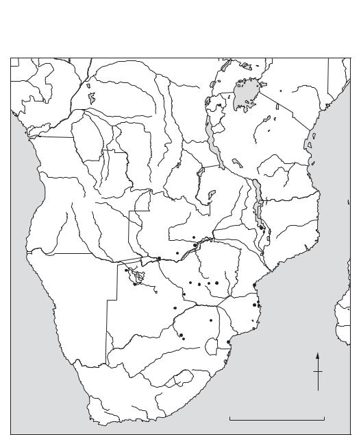
Map 5 Africa, 5: Central Some major prehistoric sites in the region.
30 AFRICA
assemblages should date to uncal c.200,000 BP. Other important Acheulean localities in Central Africa include the sites of the Sangha region in the Central African Republic, where assemblages comprising all stages of the Acheulean (lower, middle and upper) have been identified (Lanfranchi and Clist 1991). The Lunda region of Angola has likewise supplied lower and upper Acheulean industries.
SANGOAN localities are very numerous in Central Africa, although the best dated and most wellknown occurrences are on its fringes. The original sequences for the post-Acheulean stone age industries of the region were built by J. Colette at GOMBE POINT (Zaire), however the stratigraphic integrity of these sequences are now in doubt (Cahen 1976). Regardless, macrolithic ‘core tool’ industries – sometimes with and sometimes without a Levallois component – occupy the period between c.200,000 and 40,000 years ago in Central Africa. Neither palaeoclimatic studies, nor archaeological research has allowed us to view with precision the environmental context of these early occupations, and particularly whether they were within or without the rainforest.
5.2. The first microlithic industries. Some of the earliest MICROLITHIC industries in the world are found in Central Africa. These include the important sites of MATUPI CAVE (Zaire) and SHUM LAKA (southern Cameroon), where microlithic quartz industries have been shown to date at or before the ‘radiocarbon barrier’ of uncal 40,000 BP.
Matupi Cave is located in eastern Zaire, almost on the Ugandan frontier. Palynological and faunal evidence suggests that the cave was surrounded by savanna vegetation, but in proximity to gallery or rain forest throughout its ‘Late Stone Age’ occupation. The earliest stone industry at Matupi (c.<40,700 to uncal 32,000 BP) is characterized by a fully microlithic reduction technique (bipolar cores with small flakes and bladelets), but lacking true geometric microliths. Geometric microliths, presumably used in making composite tools only begin to occur at uncal c.32,000 to 21,000 BP, coupled with substantial numbers of pièces esquillées, presumably for wood-working (Van Noten 1982).
Shum Laka is one of the most recently researched rockshelter sites in Central Africa, with fieldwork only being completed there by Pierre de Maret and his team in 1994. Preliminary information from palynological, faunal and macrobotanical analyses show that it, like Matupi, was probably situated on a savanna–forest ecotone for most of its occupation (an ecotone being an area bordering two different ecological zones). The lower sediments at Shum
Laka have been dated to at least uncal 30,000 BP and contain three different quartz microlithic industries. From an Ash Member, overlying these lower sediments a group of human burials has been found dating to uncal c.7000 BP. These remains of at least 15 individuals, are associated with a microlithic quartz industry, and thus constitute the largest Late Stone Age mortuary population yet known from Central Africa. The future laboratory analyses of materials from the Shum Laka excavations have the potential to profoundly change our perception of ancient economy and populations at the edge of the rainforest.
It is interesting that all early microlithic occurrences in sub-Saharan Africa (Matupi, Shum Laka, HOWIESON’S POORT) seem to be associated with open savanna environments or savanna – forest ecotones. At their early stages at least, they are certainly not associated with deep forest environments, and indeed some authors (Ambrose and Lorenz 1990) have suggested that open environments, greater residential mobility (with greater information exchange), and the need for lighter (longer range) weapons and a more flexible toolkit may have conspired to stimulate the development of microlithic industries in Africa.
By uncal c.15,000 BP microlithic technology had become virtually universal in Central Africa. Indeed, the Central African microlithic technocomplex was to continue in Central Africa in some localities until uncal c.2000 BP.
5.3. The ‘Stone to Metal Age’ and the ‘Bantu expansion’. The advent of ceramic technology was comparatively late in Africa south of the equator, considering that the first Saharan ceramics rank amongst some of the most ancient in the world. In most of the region ceramics appear along with polished stone tools only after uncal 4000 BP, however there are a few notable exceptions.
The coastal Sablières de Libreville (Gabon) hold within them several localities where ceramics and microliths have been found within discrete ash lens dated to between uncal 6450 and 4870 BP (Clist 1995). Many scholars have asserted that these ceramics might be somehow intrusive, due to high subsurface mobility in unconsolidated sand deposits. However, as further sites in coastal Gabon, such as Nzogobeyok and Rivière Denis, have been found to have similar associations at comparable dates, the integrity of these finds is becoming more probable. If these datings are accurate, they indicate that in at least some instances pottery was appropriated or developed by Central African hunter-gatherers well before the ‘Bantu Expansion’.
The beginnings of the expansion of Niger– Congo speakers of the Bantu Super-Family into Central Africa has been placed by historical linguists at around uncal 4000 BP. The current consensus is that the core area for this expansion may be found in the Cameroon grassfields. It would seem that the first Bantu-speaking immigrants into Central Africa arrived before the beginnings of metallurgy, but with ceramics, polished stone tools and small livestock. The initial population movements could have been encouraged by the beginnings of the recent arid phase around uncal 4500 BP – opening savanna corridors into the rainforest. Additionally, it would seem that some migration was maritime (between southern Cameroon, Equatorial Guinea, and Gabon), since the island of Bioko was occupied by local seafarers around uncal 4000 BP (Vansina 1990; Clist 1995).
As research has progressed over the past few decades, it has become evident that it is no longer possible to trace a clean line in Central Africa between one period when groups were using stone tools and another in which iron implements were employed. Thus, to alleviate confusion, de Maret (1995) has suggested the use of Stone to Metal Age (or SMA) as a term for this technologically transitional period (c.4,000–2,000 uncal BP). Within the Central African SMA there would appear to be a wide diversity of local ceramic traditions and associated technologies and economies.
The sites of OBOBOGO and Nkang (Cameroon) provide us with some of our clearest economic evidence for this period. At Obobogo, ceramics, oil palm endocarps and the fruits of the tree Canarium schweinfurthii have been associated in disposal or storage pits with dates of between uncal 3625 and 2120 BP while at Nkang domesticated ovicaprines are present at around uncal 2,500 BP (de Maret 1995). These sites seem to mark the first documented occurrences of a vegecultural and small livestock management economy which appears to have slowly expanded within the Central African forests around uncal, 2000 BP potentially along river corridors.
Also in the 3rd millennium BP (uncal) interesting developments were taking place in the savanna of the Central African republic. There, in the Bouar region, numerous megalithic monuments (called locally tazunu) were being constructed. These tazunu, which number in the hundreds, consist primarily of stone aggregations of approximately 10 m in diameter and 1 to 2 m in height, with a series of monoliths placed at or around their summit. Six tazunu have been excavated and dated, providing absolutely no evidence for inhumations,
AFRICA 31
but featuring dates on associated charcoal falling between uncal 2800 and 2000 BP. Associated material culture from excavations has been rather sparse but includes some ceramics, ground stone and lithics (David 1982). In terms of function, these monuments have usually been viewed as territorial or group lineage markers.
The expansion of ceramic-using groups into the Central African forest and the Zaire Basin has been studied in recent years by the German River Reconnaissance Project (Eggert 1993). Their work established the existence of three cultural groups in the river basin on the basis of ceramic analysis. These included: the Imbonga Group (uncal 2400–2000 BP, no associated iron or stone tools), the Batalimo Group (uncal 2100–1600 BP, no associated iron, but associated polished stone axes common at the ‘type site’ of Batalimo, Central African Republic) and the Pikunda–Munda Group (uncal 2000–1700 BP, clearly associated with iron artefacts). It is unclear at this point whether or not the technological variability encountered in these groups is simply an artefact of sampling. Unfortunately no economic evidence for these groups is yet available.
The earliest indications of iron metallurgy in Central Africa come from Gabon in the Ogooué basin. There, certain localities at Otoumbi (Middle Ogooué) and Moanda (Upper Ogooué) have supplied some of the earliest dates for iron furnaces yet known in Africa (Otoumbi 2: 2640 ± 70 and 2400 ± 50 uncal BP; Moanda 1: 2350 ± 140 uncal BP and Moanda 2: 2330 ± 90 uncal BP). There is some controversy surrounding these dates since contemporary occupations in the same region are still essentially ‘Neolithic’ in material culture (Clist 1995). However, it should be remembered that the transfer to iron technology everywhere in Africa was a gradual process, with little immediate change in material culture and only a slow proliferation of metal artefacts. Indeed, by uncal 2000 BP iron technology was very widespread in central Africa.
5.4. Complex societies: the case of the Luba kingdom and its antecedents. It would seem that by the late 1st millennium AD several complex societies were in existence along the Zaire basin. Certainly by the time of European contact in the 15th century, the impressive, urbanized kingdom of Kongo already controlled the mouth of the Zaire river and the kingdom of Teke occupied much of what is now Congo-Brazzaville. However, archaeological evidence for the background to these polities is rather scarce when compared with that for the kingdom of Luba.
The historic kingdom of Luba existed during the
32 AFRICA
18th and 19th centuries in and around the riverine Upemba Depression of eastern Zaire. However, the Luba kingdom has important antecedents which are only attested by the archaeological record (de Maret 1991). Between c.AD 700 and 900, the Upemba Depression was already occupied by an apparently stratified society, featuring graves of differential status and including symbols of wealth and power (non-functional ‘ceremonial’ axes and cylindrical anvils) which would still have been recognizable as legitimation symbols at the time of the Luba Kingdom. This cultural phase, termed the Early Kisalian, was followed by a more sophisticated expression of the same cultural tradition, the Classic Kisalian (c.AD 900–1300). The graves of the Classic Kisalian reached a level of unparalleled richness, often holding in excess of 20 finely made Kisalian pots and quantities of copper bangles, necklaces, bracelets, fishhooks and spearheads, as well as objects in ivory and iron. Subsequently grave-goods decreased in quantity and diversity being replaced in the following Kabambian cultural phases (c.AD 1300–1700) by collections of copper croissettes (cross-shaped ingots which seem to have acted as a currency in parts of Central Africa at that time).
The wealth of the Kisalian period in the Upemba Depression seems to have been based upon two factors: first the abundance of freshwater fish resources in the region which allowed the formation of large sedentary settlements and even the export of dried fish, and secondly a proximity to the ‘copperbelt’ of southern Zaire and northern Zambia which allowed local elites to participate in the distribution web of copper to the coast and the interior. Interestingly, a contemporary polity at the southern end of the Upemba Depression – the Katotian – whilst featuring similar pottery and grave goods to the Kisalian, also possessed cowries, Conus shells and glass beads as tangible markers of connection with the Indian Ocean trade.
J.D. Clark: The distribution of prehistoric culture in Angola
(Diamang, 1966); D. Cahen: ‘Nouvelles fouilles à la Pointe de la Gombe (ex-Pointe de Kalina), Kinshasa, Zaire’, L’Anthropologie 80 (1976), 573–602; N. David: ‘Tazunu: megalithic monuments of Central Africa’, Azania 17 (1982), 43–8; F. Van Noten, ed.: The archaeology of Central Africa (Graz, 1982); S.H. Ambrose and K.G. Lorenz: ‘Social and Ecological Models for the Middle Stone Age in Southern Africa’, The emergence of modern humans: an archaeological perspective, ed. P. Mellars (Edinburgh, 1990), 3–33; J. Vansina: Paths in the rainforests: toward a history of political tradition in equatorial Africa (London, 1990); R. Lanfranchi and B. Clist: Aux origines de l’Afrique Centrale (Libreville, 1991); P. de Maret: ‘L’archéologie du royaume Luba’, Aux origines de
l’Afrique Centrale, ed. R. Lanfranchi and B. Clist (Libreville, 1991), 234–41; M. Eggert: ‘Central Africa and the archaeology of the equatorial rainforest: reflections on some major topics’, The archaeology of Africa: food, metals and towns, eds. T. Shaw, P. Sinclair, B. Andah and A. Okpoko (London, 1993), 289–33; B. Clist: Gabon: 1000,000 ans d’Histoire (Libreville, 1995); P. de Maret: ‘Pits, pots and far-west streams’, The growth of farming communities in Africa from the Equator southwards, ed. J.E.G. Sutton [Azania special volume 29–30] (Nairobi, 1995), 318–23.
KM
Agade see AKKADIAN
Agadez Region situated southwest of the Air massif, central Niger, which was investigated by Danilo Grébénart in 1978–81; it contains abundant remains, both above and below the Tigidit scarp, attributed to the Neolithic, Copper and Iron Ages, and the medieval period; most interest has centred on the early Copper Age, because of Grébénart’s claim that ‘an autonomous centre for the working of native copper’ developed here at that time. A total of 42 radiocarbon dates from 17 sites belonging to four phases of settlement is summarized as follows: [Phase: number of sites; number of dates; date range BP]: Neolithic (6; 8; 3390 ± 100–2795 ± 105). Copper I (3; 15; 4140 ± 90–2900 ± 100). Copper II (5; 15; 2800 ± 90–2040 ± 90). Iron I (3; 4; 2440 ± 90–2010
±90).
The scheme implies that the early Copper Age in
the Agadez region preceded and ran parallel with the Neolithic and that the late Copper Age was likewise largely contemporaneous with the early Iron Age. Some copper slag was analysed by J.R. Bourhis and R.F. Tylecote, but they did not agree in their interpretation, and a third opinion was therefore sought from N.J. van der Merwe, who with his colleagues has provided a complete reassessment of the sites attributed to the Copper Age, particularly Afunfun 175, where according to Grébénart more than 100 furnaces representative of the early period have been identified. Of the 18 structures excavated at this site, only furnace 1 produced a large quantity of fused material, and two samples of this were shown to consist of fayalitic iron-smelting slag, directly dated by accelerator mass spectrometry to 1510 ± 100 BP. The structure itself was identified as a burnt-out tree stump, and, as van der Merwe comments, ‘a span of more than two millennia’ therefore separates the formation of this structure from ‘its use as an iron-smelting furnace’. Only four of the other structures attributed to the early Copper Age are considered to be definitely furnaces
of some kind, and there are only four samples of fayalitic copper-smelting slag, most of them being no more than partially vitrified soils. Only furnace 8 has both a radiocarbon date (3660 ± 110 BP) and a residue containing 1% copper, but because of the proven use of fossil charcoal at the site, van der Merwe warns, even this date cannot be taken at face value until it is supported by a thermoluminescence date on the fired lining of the furnace. All in all, therefore, the evidence for metallurgy in Niger prior to 3000 BP ‘must remain in doubt’ (Killick et al. 1988: 390).
The same doubts do not apply to the late Copper Age, characterized by standard non-tapping shaft furnaces and distinctive red melilite slag, the product of a true smelting process. Grébénart emphasizes that only 85 m3 of slag has been recovered and that over a thousand year period the mean annual production of copper will have been no more than 8.5–17 kg. The smelters therefore were itinerant craftsmen and the manufacture of metal was only an occasional activity. The small artefacts produced were hot-hammered, and the lost-wax technique was unknown, although there were some moulded ingots, and some bronze and brass alloys were used mainly for jewellery.
Ironand copper-working continued in this region during the medieval period, at Marandet and Azelik respectively, the latter probably being equivalent to the town of Takedda visited by Ibn Battuta in AD 1354.
D. Grébénart: ‘Characteristics of the final Neolithic and Metal ages in the region of Agadez (Niger)’, Prehistory of arid North Africa, ed. A.E. Close (Dallas, 1987), 287–316; D. Killick et al.: ‘Reassessment of the evidence for early metallurgy in Niger, West Africa’, JAS, 15 (1988), 367–94; D. Grébénart: ‘L’âge du cuivre au Sahara central et occidental’, Sahara 5 (1992–3), 49–58.
PA-J
Agordat Set of four small settlement sites in western Eritrea, Ethiopia, none of which have yet been excavated or properly dated, although surface finds of ground stone tools and figurines suggest that they may have been connected with the Nubian C GROUP of the late 3rd millennium BC. This would indicate possible links between the cereal-based Neolithic cultures of northern Ethiopia and the Nile Valley.
A.J. Arkell: ‘Four occupation sites at Agordat’, Kush 2 (1954), 33–62.
IS
Agrab, Tell see DIYALA REGION
AGUA BLANCA 33
A Group, A Horizon Semi-nomadic Neolithic culture, characterized by black-polished and ‘eggshell’ handmade pottery, which flourished in Lower Nubia from the mid-4th millennium BC until at least 2800 BC (i.e. roughly contemporary with the Egyptian late predynastic period and 1st dynasty). The term ‘A Group’ was first used by George Reisner (1961). W.Y. Adams later attempted (unsuccessfully) to replace it with the term ‘A Horizon’ in order to tone down the migrationist implications of Reisner’s designation (see DIFFUSIONISM). A-Group cemeteries have been excavated at a number of sites, including Qustul and Sayala.
G. Reisner and A.J. Arkell: A history of the Sudan, 2nd edn (London, 1961), 37–45; H. Nordström: Neolithic and A-group sites (Stockholm, 1972), 17–32; W.Y. Adams: Nubia: corridor to Africa, 2nd edn (Princeton, 1984), 118–32; H.S. Smith: ‘The development of the A-Group “culture” in northern Lower Nubia’, Egypt and Africa, ed. W.V. Davies (London, 1991), 92–111.
IS
Agua Blanca Village in the Manabí province of Ecuador, which provides a prime example of a grass-roots approach to archaeological education and site preservation. An intense drought in Manabí in the 1970s led to intensified logging as an alternative to the failing agricultural system. In addition to destroying the forest, the local people looted the archaeological sites they encountered, selling the artefacts to a local dealer for muchneeded cash. In 1979 the Machalilla National Park was created to preserve the forest and fauna of the Ecuadorian coast. No provision was made for communities such as Agua Blanca which were within the park boundaries. In the same year an archaeological project was inaugurated, with the aim of surveying the valley, including a large, important Manteño-culture (AD 1300–1500) site.
The head of the project, Colin McEwan, moved into the village hall in 1980; this made the project highly visible, and interested local people were able to ask about the project and about archaeology in general. This interest led to impromptu classes in archaeology, and as the project grew to include excavation, more members of the community were incorporated and trained in archaeological methodologies by María Isabel Silva. Both the visibility of all parts of the project and the direct involvement of some community members brought the past directly into the community and it became a source of interest and community pride – something that belonged to them, as well as a source of income for some. A small exhibit organized in the town led to
34 AGUA BLANCA
an interest in building a more permanent one, and funds were obtained for a local museum and cultural hall. The entire town participated in the construction of these buildings; discussions and outside speakers were organized; and a site exhibit was installed.
The Agua Blanca project was based on respect for local people and on a recognition of their expressed needs and wishes; the project has increased community solidarity, giving members the strength and the skills to deal with outside planners who do not normally consider country peoples’ needs in their projects. Looting has ceased, as short-term gains are passed up for long-term advantages, including employment within the park, the building and maintenance of tourist facilities, and work as guides.
C. Hudson and C. McEwan: ‘Focussing pride in the past: Agua Blanca, Equador’, Museum 154/2 (1987), 125–8; M.I. Silva and C. McEwan: ‘Machalilla: el camino de integración’, Colibrí 2/5 (1989), 71–5; P. Norton, ed.:
5000 años de ocupación: Parque Nacional Machalilla
(Quito, 1992).
KB
Aguada Site in northwestern Argentina, dating to c.AD 600–1200, best known for its elaborate bronze ornaments and ceramics decorated with supernatural feline or ‘draconian’ motifs which have inspired considerable interest in the diffusion of motifs and/or mythic themes throughout the Andes.
A.R. Gonzalez: Las placas metálicas de los Andes del Sur
(Mainz am Rhein, 1992).
KB
Ahar see BANAS
ahu Sacred stone structures found in central and eastern Polynesia, but also in New Zealand. Ahu took the form of lines of stones or, more commonly, a platform. The most famous are the ahu of EASTER ISLAND, which acted as a platform on which the famous statues were placed. Thor Heyerdahl considered the Easter Island ahu to have a South American derivation, but their widespread occurrence throughout Polynesia demonstrate their Pacific origin.
P. Bellwood: Man’s conquest of the Pacific (New York, 1978), 329–30; P.V. Kirch: The evolution of Polynesian chiefdoms (Cambridge, 1984), 264–78.
CG
Aihole Town-site of the 6th–12th centuries AD (Chalukya and Rastrakuta periods), in Mysore, India, consisting of a large fortified hill in the south-
east, at the foot of which lay a walled settlement containing many elaborately sculpted Hindu and Jain stone temples. Some of the latter are free-standing structures while others are carved into the surrounding hills.
R.S. Gupte: The art and architecture of Aihole (Bombay, 1962); S. Rajasekhara: Early Chalukya art at Aihole (New Delhi, 1985).
CS
Ain Ghazal Very large Pre-Pottery Neolithic
(see ACERAMIC NEOLITHIC) and Yarmukian
(ceramic Neolithic) settlement-site adjacent to Amman in Jordan, which was occupied during the 8th, 7th and 6th millennia BC. Gary Rollefson’s excavations (from 1983 onwards) uncovered two pits containing sets of anthropomorphic statues dating to the Pre-Pottery Neolithic B period, as well as a third pit containing fragments of plaster from a plastered skull. The statues range from 35 cm to 90 cm in height and are made up of lime plaster modelled around armatures of reed and twine, the eyes being applied in the form of a bituminous substance. Similar statues, perhaps used in religious ceremonies, were also found at JERICHO and Nahal Hemar, a cave to the southwest of the Dead Sea.
G.O. Rollefson: ‘Ritual and ceremony at Neolithic Ain Ghazal’, Paleorient 9/2 (1983), 29–38; ––––: ‘Early Neolithic statuary from Ain Ghazal (Jordan)’, MDOG 116 (1984), 185–92; A.H. Simmons and G.O. Rollefson: ‘Neolithic Ain Ghazal (Jordan): interim report on the first two seasons, 1982–1983’, JFA 11 (1984), 387–95; G.O. Rollefson et al.: ‘Neolithic cultures at Ain Ghazal, Jordan’, JFA 19 (1992), 443–70.
IS
Ain Hanech |
see AFRICA 1 |
Ain Mallaha |
see NATUFIAN |
Ainu Term used to describe former fisher-hunter- gatherers who also practised some millet cultivation and occupied the islands of Hokkaido in Japan and Sakhalin in the Russian Federation. Ainu culture developed out of the SATSUMON and OKHOTSK cultures. Historically formulated ethnic groups first documented in the 16th–17th centuries AD, they have long been mistakenly identified as the direct successors to the Jomon populations of Japan (see
JAPAN 2–3).
H. Watanabe: The Ainu ecosystem: environment and group structure (Seattle, 1973); Y. Fukasawa: ‘Emishi and the Ainu: from an archaeological point of view’, Paper presented at ‘Japanese archaeology in protohistoric and early historic period: Yamato and its relations to surrounding populations’: international symposium at the University