

A Dictionary of Archaeology
.pdfpottery vessel (especially a four-handled jar), sometimes with a bronze dagger. Both groups of tumuli are large, the First Series producing most of the exceptionally sized examples; the First Series tombs are concentrated in Finestère and Morbihan near the coast, while the Second Series graves tend to occur inland. First Series tombs tend to be earlier, although the chronological relationship is complex and as yet not fully resolved. The flint arrowheads, bronze daggers and occasional stone wristguards found in the First Series can be compared to the ‘prestige item’ assemblages found with Beaker pottery elsewhere in Europe, though Beakers themselves are not present.
Armorican series and Wessex. The Armorican graves
– particularly the First Series – are comparable to the barrows in southern Britain produced by the WESSEX CULTURE. The most important differences in the material assemblages are that the Wessex graves lack the emphasis on elaborate arrowheads and the long ‘sword’ daggers found in Brittany, do not tend to show such accumulations of axes and other weaponry, and are accompanied by Beakers; the most important assemblage similarities are the shared Armorico-British daggers and, at the level of individual sites, the hilt decoration of gold pins at Kernonen and BUSH BARROW.
J. Cogné and P.-R. Giot: ‘L’âge de bronze ancien en Bretagne’, L’Anthropolgie 55 (1951), 425–44; J. Briard: Les tumulus d’Armorique (Paris, 1984); D.V. Clarke et al.:
Symbols of power at the time of Stonehenge (Edinburgh, 1985), 128–40.
RJA
Arpachiyah, Tell Prehistoric site dating to the 5th and 6th millennia BC, located 6 km northeast of the site of Nineveh in the Mosul region of northern Iraq. It was excavated by Max Mallowan in 1933, his attention having been drawn to the site by Campbell Thompson’s discovery of surface finds of HALAF pottery in 1928. Mallowan hoped that by excavating the easily accessible Halafian strata at Arpachiyah he would shed further light on the context of the Halaf pottery which he had discovered in the deepest strata at Nineveh in 1932. At Arpachiyah he identified ten building phases (TT1–10): the four uppermost of which (TT1–4) contained the distinctive painted pottery of the UBAID period (c.5000–3800 BC), while the six lower phases were Halafian in date (c.5500–4500 BC). In levels TT7–10 he discovered a large group of unusual circular (perhaps domed) structures, which he described as tholoi because their shape resembled that of a Mycenaean THOLOS tomb.
In 1976 the excavations of Ismail Hijara demon-
ARZAWA 75
strated that there were six further Halafian levels below Mallowan’s lowest stratum. Hijara distinguished three broad ceramic phases of the Halafian period at Arpachiyah, the earliest of which was built directly on the natural soil and consisted of rectangular mud-brick buildings rather than the circular tholoi of the later levels. In the latest Halafian strata (i.e. Mallowan’s TT7–10), Hijara also identified a wall separating the tholoi from the rest of the Halafian settlement, perhaps indicating that the buildings served a religious rather than domestic function.
M.E.L. Mallowan and C. Rose: ‘Prehistoric Assyria: the excavations at Tell Arpachiyah, 1933’, Iraq 2 (1935), 1–178; T.E. Davidson and H. McKerrell: ‘The neutron activation analysis of Halaf and ‘Ubaid pottery from Tell Arpachiyah and Tepe Gawra’, Iraq 42 (1980), 155–67; J. Curtis: ‘Arpachiya’, Fifty years of Mesopotamian discovery, ed. J. Curtis (London, 1982), 30–6.
IS
Arras culture Iron Age culture (4th–1st centuries BC) of eastern Yorkshire, England, known largely from its barrows with pit burials. Some burials contain elaborate cart burials, as at the type site of Arras, and at Wetwang Slack and Garton Slack (Dent 1985). At the latter site, four cart burials outside the main cemetery contained dismantled two-wheeled carts with iron tyres and hubs laid underneath a flexed skeleton; grave goods included iron swords in iron and bronze scabbards with circular open chapes characteristic of the earlier La Tène, iron horse-bits and an iron mirror and bronze container. Because the barrows and the cart burials are similar to La Tène burials found in the Seine valley and north France around the 5th century BC, the Arras culture is often cited as an example of immigration into, or invasion of, the British Isles (at least, by an aristocratic elite) during the later 1st millennium BC.
J. Dent: ‘Three cart burials from Wetwang, Yorkshire’, Antiquity 59 (1985), 85–92.
RJA
arrow straightener Prehistoric stone plaques characterized by a carved and worn groove, which are thought to have been used to smooth arrowshafts.
Arroyo Hondo see ANASAZI
Arslantepe see MALATYA
Arzawa see BEYÇESULTAN
76 ARZHAN
Arzhan Large barrow of around the 8th to 7th centuries BC located in the valley of the Uyuk river, Republic of Tuva (southern Siberia), Russia. Discovered and excavated by M.P. Gryaznov in 1971–4, the chamber contained burials of a ‘king’ and ‘queen’, the skeletons of 15 human attendants and 160 horses. Grave goods included horse gear, weapons and works of art in the SCYTHIAN tradition.
M.P. Gryaznov: Arzˇan: carskii kurgan ranne-skifskogo vremeni [Arzhan: a royal kurgan from early Scythian times] (Leningrad, 1970).
F.R. Allchin: Neolithic cattle keepers of the Deccan
(Cambridge, 1963).
CS
Asia
Sections: 1 Central Asia; 2 South Asia; 3 Southeast Asia. The archaeology of Western Asia is discussed in the following articles: ANATOLIA; ARABIA;
ISLAMIC ARCHAEOLOGY; MESOPOTAMIA; SYRIAPALESTINE.
1 Central Asia
PD
Ashdod see PHILISTINES
Ashkelon see PHILISTINES
ash-mound sites Characteristic sites of the south Indian Neolithic period in modern Karnataka (c.2800–1500 BC), consisting of low mounds of burnt cattle dung and associated faunal remains and artefacts. They have been interpreted by Allchin (1963: 162–7) as the remains of series of cattle pens which were repeatedly burnt and rebuilt over several phases. The precise reasons for burning remain unknown, whether accidental, for hygienic reasons, or for ritual purposes (Allchin 1963: 76). Associated materials include domestic cattle bones, hand-made ceramics, chipped stone blades and cores, ground stone axes and grinding stones.
The prehistory and archaeology of this vast area is to some extent dependent upon its diverse geography. The larger part of Central Asia is taken up by the Turanian Lowland: a huge trough filled with clastic deposits. An impressive belt of folded mountains separates this region from the Iranian and Indian lowlands to the south. This mountainous belt, oriented roughly northwest to southeast, comprises the Kopet Dag (or Koppeh Dagh, the northern ridge of the Khorassan Mountains), Pamir, Alai and Tien Shan. The northern fringe of the Kopet Dag forms ‘piedmont foothills’: a cluster of alluvial fans shaped by numerous streams. The climate is continental and very dry (mostly under 250 mm of rainfall annually). The wettest areas are found on the northern slopes of folded mountain belts (350–450 mm), while the foothills of the Kopet Dag are very rich in groundwater. Central Asia drains inwards: its major basins (the Caspian Sea, the Aral Sea) have no outlet to the oceans.
Sea
KAZAKHSTAN |
Aral Sea |
KAZAKHSTAN |
|
Ust-Urt
Plateau  Kyzyl Kum
Desert
Sarykamysh |
Kelteminar- |
|
|
related sites |
KYRGYZSTAN |
|
|
|
|
|
Tashkent |
|
|
UZBEKISTAN |
Caspian
N
Jebel |
|
|
|
Uzboi |
|
|
Kara Kum |
|
||
|
|
|
|
|
|
|
|
|||
|
|
|
|
|
|
|
|
|
Desert |
|
|
|
|
|
|
|
|
|
|
|
Bukhara |
|
Sumbar |
|
|
|
TURKMENISTAN |
|||||
|
|
|
|
Jeitun |
|
|||||
|
|
|
|
|
|
|
|
|
|
|
|
|
|
|
|
|
|
|
|
Ashkabadh |
|
|
|
|
e |
t |
D |
a |
g |
Kara-Depe |
Yaz |
|
|
|
p |
|
|||||||
|
o |
|
h |
|
Geoksyur |
|||||
K |
|
|
|
|
||||||
|
|
|
|
Namazga |
||||||
|
|
|
|
|
|
|||||
|
|
|
|
|
|
|
|
|||
|
|
|
|
|
|
|
|
|
|
|
|
|
|
|
|
|
|
|
|
Altyndepe |
Khapuzuz |
|
|
|
|
|
|
|
|
|
|
|
|
|
|
|
IRAN |
|
|
|
|
|
|
0 |
|
|
|
|
|
|
|
300 km |
|
|
Samarkand |
Sarazm |
|
|
|
|
Hissar- |
|
|
|
related sites |
|
|
Teshik |
|
|
|
Tash |
|
TAJIKISTAN |
|
|
|
|
Sapalli |
Termez |
|
|
Dashly |
|
|
|
Akcha |
|
|
|
Tillya |
|
AFGHANISTAN |
KASHMIR |
|
|
|
|
|
|
|
PAKISTAN |
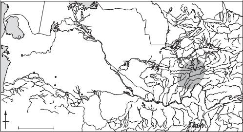
Map 15 Asia, 1: Central Major sites in the region mentioned in the main text or with individual entries in the Dictionary.
The southern part of Turanian Lowland is occupied by the two huge deserts of Kara Kum and Kyzyl Kum. The coarse clay and sand deposits found here were deposited by the Amy-Darya (Oxus) and Syr Darya rivers, which repeatedly changed their course during the Pleistocene and Holocene. The scarce desert vegetation of much of this area contrasts with rich tugai forests (poplar, willow, tamarisk etc.) restricted to river valleys. The northern part of the Turanian Lowland forms an undulating plain covered by steppe-like vegetation. Until comparatively recently, the now-barren slopes of the mountains were covered by deciduous forests offering a great variety of wild fruit trees; the foothills of Kopet Dag still support a wide variety of wild cereals.
1.1 Cultural sequence. The earliest evidence of hominids in the region comes from the long loess sequences in the Southern Tadjik depression. At one of the sites, KULDURA, archaic choppers were found in fossil soils exhibiting a reverse polarity, suggesting an age of c.800,000 years (Ranov 1993). A sequence of loess deposits in southwest Tadjikistan suggests an uninterrupted settlement of that area throughout the entire Pleistocene. Sites in other areas allegedly belong to Lower Palaeolithic: the cave of Sel Ungur in Fergana valley, and Kul’bulak, southeast of Tashkent. Several finds of bifacial tools have been reported from southern Kazakhstan.
More than 100 Mousterian sites, apparently belonging to the early stadials of the last glaciation (radiocarbon dates from the sites of Ogzi-Lichik and Khoudji suggest an age of 40–30,000 years) demonstrate a degree of cultural diversity in the Middle Palaeolithic: artefacts can be grouped into at least four typologies (Ranov 1993). The deliberate burial of a Neanderthal child at TESHIK-TASH suggests some kind of ‘religious’ beliefs.
The stratified site of Shugou was found in Tadjikistan, at an altitude of c.2000 m above sealevel. The site consists of five levels which yielded radiocarbon dates from 35,000 to 10,000 years BP. The stone industries include Mousterian and Upper Palaeolithic tools, end-scrapers and points being the most numerous. This combination of Mousterian and Upper Paleolithic artefacts is also typical of another site, found in the city of Samarkand, Uzbekistan. Judging from the location of sites and faunal remains, these were seasonal camps left by hunters procuring wild animals such as horse, camel, red deer and goat.
Mesolithic sites are found almost exclusively in the mountainous regions – notably, the cave sites Jebel and Dam-Dam-Cheshma 1 and 2 in the
ASIA 77
Greater Balkans, the northwestern off-shoot of the Kopet Dag. A third cave, Kaylyu, lies in a cliff of the Caspian Sea in the Krasnovodsk peninsula (Okladnikov 1955: 1966). A number of Mesolithic sites have also been discovered in the eastern part of Central Asia: the cave of Machai (Islamov 1975); Obishir 1 and 5 in the southern Fergana valley; TutKaul, Sai-Sayod, Oshkhona and others in the western Pamir (Ranov 1993).
Around 6000 BC, judging from a series of AMS datings for the site of Jeitun in Turkmenistan, the earliest farming settlements in Central Asia began to appear in the foothills of the Kopet Dag, and especially the northern foothills of the Khorassan Mountains. They belong to the JEITUN culture, and were predominantly agricultural (especially einkorn wheat), with stock-breeding (mostly sheep and goats) supplemented by hunting (Masson 1971; Harris et al. 1993).
The next stage in the early agricultural sequence of Central Asia is referred to as Anau IA and dates to 5200–4800 BC (Kohl 1984). Several clusters of Anau IA sites are distinguishable: the western group (west of Ashgabad), the central group (near Kaakhka), and a group in the eastern part of the ‘piedmont foothills’ (the Meana-Chaacha interfluve). Local differences in stock-breeding become apparent: pig being the most numerous in the western group, with either sheep/goat, or cattle, dominating elsewhere. Domestic architecture became technically more sophisticated: complexes of houses built of mud-bricks of a standard size and separated by narrow alleys.
In the subsequent stage in the cultural sequence, referred to as NAMAZGA I and dating from 4800 to 4000 BC (Kohl 1984), the number and size of settlements (and presumably population levels) increase particularly in the central foothills (Namazga 50 ha, and Kara-depe, 6–8 ha). The settlements usually consisted of a large number of one-roomed houses without marked social distinctions; towards the end of the period, the houses tend to form denser clusters but there are no obvious defensive walls. Smaller agricultural settlements appeared further east in the Tedjen delta. The intensification of agriculture depended upon the development of irrigation, which is clear around the settlement of Namazga and, particularly, in the Tedjen delta.
The first half of the 4th millennium BC, corresponding to the Middle Eneolithic, is known locally as Namazga II. Sites cluster around Ashgabad and in the northeast piedmont foothills, notably Namazga, Kara-depe and ALTYN-DEPE. The protourban nature of these settlements is particularly striking in the northeastern sector, where there is a
78 ASIA
marked settlement hierarchy (Masson 1989). At least two settlements, Altyn-depe and Ingynlydepe, exceeded 15 hectares; the former was encircled by a wall 1.5 m thick with rectangular towers. A network of settlements based on irrigated agriculture evolved in the Tedjen delta (Khlopin 1964).
The Namazga III stage (or Late Eneolithic) corresponds to the second half of the 4th millennium BC. There was remarkable increase in urbanization, particularly in the central and northeastern sectors of the Kopet Dag piedmont. Namazga and Altyn-depe grew to 30 ha each – while smaller sites tended to diminish or to disappear. Agricultural settlements also emerged further east in Central Asia in the Murghab delta (Margiana) (Masimov 1981).
The Namazga IV stage, or Early Bronze Age, corresponds to the first half of the third millennium BC. Settlements continued to grow: Namazga and Altyn-depe reached c.50 and 25 ha, respectively (Mason 1991). Yet the general settlement pattern changed considerably: settlements totally disappear from the Tedjen delta, although they are still present in the Murghab delta (Masimov 1981). Agricultural settlements spread into the intermontane valleys of the Kopet Dag; settlements and cemeteries appeared in the SUMBAR valley of western Kopet Dag (Khlopin 1983).
During the Middle Bronze Age, or Namazga V stage, of the second half of the 2nd millennium BC, the development of proto-urban civilization in the south of Central Asia reached a climax. The excavation of Altyn-depe (Masson 1991) revealed advanced social stratification and craft specialization: the settlement included an elite quarter, a potter’s area, a sanctuary and a priest’s house. There is clear evidence for monumental architecture in the form of a ‘ziggurat’-like structure on a high stepped platform, and for long-distance trade in prestige goods.
Agricultural settlements continued to develop in the Murghab delta, and there is evidence for agricultural expansion further east, into the area of historic Bactria. Agricultural settlements north and south of Oxus Sapalli-tepe in southern Tadjikistan and the Dashly group in northern Afghanistan (Askarov 1973; Sarianidi 1977) show a cultural development similar to that of Margiana in the Murghab delta. The agricultural communities of the intermontane valleys of the western Kopet Dag (Khlopin 1983) developed rather differently, and a particular cultural tradition of catacomb graves developed.
At the same time, a totally different line of socio-
cultural development emerged in the north of Central Asia, on the Turanian Lowland. In conditions of increased rainfall (the ‘Lyavlyakan pluvial’), a network of settlements based entirely on foraging strategies emerged along numerous waterways – and especially along the Amu Darya river, which flowed directly to the Caspian Sea, via Sarykamysh lake and Uzboi. A large cluster of sites is located in the ancient deltas of Amu-Darya, notably Akcha-Darya, and along the Zerafshan further south. Numerous sites are also situated in the Amu-Darya–Syr-Darya interfluve, in the proximity of the fresh-water lakes of that area (Vinogradov and Mamedov 1975; Vinogradov 1981).
The faunal remains at these sites consist of wild animals adapted to tugai forests, open steppes and desert mountains (red deer, fallow deer, boar, saiga, gazelle, camel etc.). Hunting waterfowl and fishing were also important. Food-gathering included a wide spectrum of plants (pomegranate, apricots, wild olives), small animals (e.g. tortoise) and molluscs (Okladnikov 1955; Vinogradov 1981). The stone inventories include grinding stones, mortars and pestles as well as blades with sickle gloss (Korobkova 1969). Vinogradov (1981: 139) describes a sophisticated technology for harvesting and processing wild plants. The remains of rectangular houses, with the roof supported by posts, were identified at a number of sites. Some of the sites, particularly in the Akcha-Darya delta, are of a considerable size and of a permanent character.
In the mountain valleys of western Tadjikistan numerous food-gathering groups, known collectively as the ‘HISSAR culture’, survived over a considerable period of time (7000 to around 2000 BC) (Amosova et al., 1993). The sites are of a considerable size (0.75–0.5 ha) and include stone floors and hearths.
The development of early metal-working communities, based on the cultural contacts with the Geojksyur and other agricultural areas and on rich local metallurgical resources, is exemplified at the site of SARAZM in the Middle Zerafshan Valley, dated to 3250–2750 BC (Isakov 1981).
The environment of Central Asia changed dramatically between 3200 BC and 2500 BC, as levels of rainfall dropped. The Sarykamysh lake, and numerous other lakes in the Kyzyl-Kum, gradually dried up; the Uzboi river ceased to exist soon after. This may be connected to a contemporary change in settlement pattern in the Kopet Dag foothills further south. Over a short time-span – c.2170–2050 BC (Dolukhanov et al. 1985) – the large proto-urban settlements (notably, Altyn-depe and
Namazga) disappeared. Numerous small villages (less than 2 ha) emerged in their place, and stockbreeding became much more important.
At the same time, in the northern part of Central Asia, there was gradual but fundamental shift to a predominantly stock-breeding economy. Yet even in areas with a semi-desert environment, large permanent settlements emerged. The economy of the site of Batai in northern Kazakhstan, dated using radiocarbon to around 2900 BC (Zaibert 1993), was entirely based on horse-breeding (99.9% of the faunal remains). However, the remains of numerous dwellings, workshops and storage pits leave no doubt that this was an established settlement.
In the same period, sites appeared in some areas of western Central Asia that exhibit marked similarities to the steppe cultures of the north
(Andronovo, TIMBER GRAVE CULTURE); the
cemetery of Kokcha-3 in the delta of Amu-Darya contained bronze objects that have analogies with those from sites in northern Kazakhstan and further to the west. Several sites in the Akcha Darya delta yielded imported Andronovo wares.
The contemporary Tazabagiab settlements present evidence of developed stock-breeding combined with irrigated agriculture (in river deltas). Andronovo-influenced local variants of a similar subsistence pattern can be identified in the Tashkent oasis, in eastern and central Kazakhstan, northern Kirghizia and Fergana Valley.
The interesting ‘Yaz I’ complex of the NamazgaAnau area of southeast Turkmenistan developed during the early 1st millennium BC (the early site of Tillya 1 has been dated using radiocarbon to 1140–940 BC). Combining stock-breeding (showing an ever-increasing amount of horse bones) with irrigated agriculture, Yaz I-type sites exhibit impressive fortifications (‘citadels’) often built on thick brick platforms. The predominance of handmade ware, and the style of certain bronze artefacts, suggest that this culture resulted from an invasion of the area by ‘steppe’ groups from the north.
The ‘Chust culture’ which emerged in the Fergana Valley during the late second to early first millennia BC may have had a more agricultural economy, although the evidence is not clear. It has been suggested (Kohl 1984), that the culture resulted from the contact of local pastoral groups with agricultural newcomers; there is also evidence of cultural contacts with Eastern Turkestan (Xinjiang). The earlier sites have been radiocarbon dated to c.1500–1100 BC, but the later sites are not yet securely dated. The largest settlements (Dalversin, Ashkal-depe) were in excess of 25 ha,
ASIA 79
while other were of a medium (Chust: 4 ha) and small (under 1 ha) size. There is no clear evidence of fortifications.
During the middle of the 1st millennium BC, the greater part of Central Asia became the eastern satrapies of the Achaemenid empire. Achaemenid sources mention several Central Asian tribes (the Bactrians, the Sacae and the Choresmians) in connection with military expeditions mounted against Egypt and Greece. By this time (the 6th to 4th centuries BC) major cities existed in all the principal regions of Central Asia: GyaurKala (Merv), Kakaly-Gir (Khorezmia), Afrosiab (Sogdiana) etc. After the conquest of Alexander (329–327 BC), and until 130 BC, a major Greco-Bactrian kingdom dominated cultural developments in Central Asia. The impressive urban centres of that time combine local cultural traditions with Hellenistic influences.
The involvement of central Asia in transcontinental trade (it occupied a central position along the ‘Great Silk Road’) further enhanced the urban economies and culture. In the first and second centuries AD, Central Asia became part of the Kushan Kingdom, the establishment of which coincided with the spread of Buddhism.
The SASSANIAN (i.e. Iranian) offensive against Kushan, combined with pressure from nomadic groups in the north, eventually destroyed the kingdom in the 4th century. Between the downfall of the Kushan Kingdom and the Arab conquest of the 8th century a number of independent cultural centres developed in various parts of the Central Asia. Perhaps the most interesting example is the urban site of Pendjikent, east of Samarkand, which has provided outstanding examples of early medieval art and architecture in Central Asia in the 5th to early 6th centuries AD (Belenitsky 1969).
1.2 Growth and decline of proto-urban cultures in Central Asia: analysis. The large land-locked area of Central Asia had limited contacts with the outer world, so that internal and external developments are relatively easy to distinguish. Agriculture can be first identified in the better watered ‘piedmont strip’ of the Turkmeno-Khorassan mountains in the late 5th to early 4th millennia BC. This area is particularly suited to early forms of agriculture: wild varieties of barley and wheat still form considerable stands on the mountain slopes. Vavilov (1926) considered this area as the ‘TurkmenoKhorassan sub-centre’ of the West Asian centre of origin of cultivated plants.
The earliest agricultural settlements here belong to the ‘Jeitun culture’, and are found on both sides of the Khorassan Mountains, in southern
80 ASIA
Turkmenistan and northern Iran. In spite of the rich local resources, early agriculture in the central Asia clearly resulted from the contacts between local Mesolithic groups and early farmers in the agricultural heartland further south in the Zagros foothills.
The further spread of agriculture during the next stage (Namazga I), east into the Tedjen delta, is seen by Khlopin (1964) as resulting from the outflow of surplus population from the Kopet Dag foothills. Subsequently, a dense network of agricultural settlements arose in these foothills and the deltaic plains, some of which reached impressive dimensions (e.g. Namazga). The settlement network was bound together by multiple trade and social links. At the same time, there is an increasing evidence of long-distance trade with the areas in the south, particularly in prestige items intended for the emerging elite e.g. lapis-lazuli and alabaster imported from Afghanistan and Iran.
Contacts with the outside world became yet more intense during the first half of the 4th millennium BC (Namazga II period). Typical Namazga II ceramics and terracottas have been identified in the Quetta assemblage in northern Baluchistan, while strong cultural parallels in pottery styles, anthropomorphic figurines, stamp steals and burial rites can be seen in distant sites such as Mundihgak (Afghanistan) and Shahr-i-Sokhta (Sistan, eastern Iran).
During the second half of the 4th millennium BC (Late Eneolithic, or Namazga III stage), when a remarkable phase of urbanization took hold in the central and northeastern sectors of the Kopet Dag, and agricultural settlements emerged in the Murghab delta (Margiana) further east (Masimov 1981), the cultural influence of Central Asia is clear throughout northern Iran. This is demonstrated in pottery assemblages from Khorassan, the Gorgan Plain and the northern fringes of the Iranian plateau (including Tepe Hissar). Again, Central Asian styles appear further south at Quetta in Baluchistan, Mundighak in Afghanistan and Shahr-i-Sokhta in Sistan. At the latter site, Namazga III-related pottery comprises 40% of the corpus of painted pottery.
During the Middle Bronze Age, or Namazga V (later 2nd millennium BC), proto-urban civilization developed strongly in the south of Central Asia. As described above, the excavation of Altyn-depe (Masson 1991) revealed a social elite and indications of the long-distance trade in prestige goods (e.g. ivory). Two seals with the signs in the Proto-Indus script prove the presence of individuals (presumably merchants) from the Indus Valley.
Eventually, the entire area north and south of the Khorassan Mountains was incorporated into a major socio-cultural network that exhibited most of the common features of ‘civilization’: a hierarchy of sedentary settlements; craft specialization and an increasingly regulated the work force; wide distribution of material goods; and emerging social stratification. This network, referred to as ‘prehistoric Turan’ by Biscone and Tosi (1979) and as ‘l’Iran exterieur’ by Amiet (1988), was linked by multiple ties with the main trade centres in the Indus Valley, eastern Iran and Elam. Kohl (1989) has even suggested a Bronze Age ‘world system’ of interconnected civilised areas which embraced the entire Middle East and included the Caucasus, Central Asia and the Indus Valley. This system consisted of localized areas bound together by trade links and by a constant movement of people, ideas and symbols.
At the same time, as described above, a different network was formed to the north, in the plains of the Turanian Plateau, by foraging communities. Thus two major socio-cultural networks are identifiable in the Central Asia during the wetter period: the agricultural network, restricted mainly to the Kopet Dag foothills and the deltaic plains in the south and linked by numerous ties with the centres of agricultural civilization in the Middle East and Indus Valley; and the foraging network, situated predominantly along the waterways of the otherwise desert-like Turanian lowland. Yet, the artefactual assemblages leave one in no doubt that the two networks were bound together by intensive social, economic and cultural contacts. The spread of pottery production may be viewed as an adoption of the southern technological innovation by the northern ‘Mesolithic’ groups, and the continuing similarity in the ornamental patterns on the pottery is proof of constant cultural contacts. Korobkova (1969: 146–8) stresses the similarity in the technique of manufacture of sickle blades in the Jeitunian and Zerafshan groups.
As described above, the environment of Central Asia dramatically changed around 3200–2500 BC. The proto-urban settlements in the south (notably, Altyn-depe and Namazga) gave way to numerous small villages leading to what has been termed a ‘crisis of urbanization’ around 2170–2050 BC (Biscone 1977; Dolukhanov et al. 1985). Spectacular changes also occurred in the semi-desert and steppe areas to the north, where the entire hydrological system of Amu-Darya-Sarykamysh-Uzboi gradually collapsed. The pastoral economy became the dominant strategy of survival throughout the entire steppe belt of Eurasia.
In the south, the small village economy was gradually absorbed into the world of ‘aggressive pastoralism’. This process manifested itself in the spread of new ideological symbols: the catacomb burial ritual is often viewed as an incursion from the steppe cultures of the north, and has suggested to many authorities the complete collapse of protourban civilization and even a barbarian occupation (Kohl 1984). However, given the aridization of the climate, the transition to a pastoral economy may instead have been a response to acute ecological crisis. Heightened competition for scarce resources can lead to a sharpened sense of group identity and the maintenance of group boundaries (Hodder 1982: 193). Perhaps this ecological crisis undermined the economic, cultural and economic system that incorporated the agricultural south into the greater network of early Middle Eastern civilization, and caused its replacement by a very different network of pastoral chiefdoms – a network that eventually dominated the greater part of the semi-desert and steppe area of Eurasia.
Two distinct processes of social integration are thus distinguishable in prehistoric Central Asia. The first consisted of a large social network consisting of the centres of early agricultural civilization and a linked, if distinctive, ‘foraging periphery’. The unity of this network was based on the circulation of goods, ideas and symbols. The second process, generated by a quite different ecology and economy, manifested itself as a multitude of localized powerbases emitting strong symbolic signals of cohesive group identity.
1.3 History of archaeology in Central Asia. Archaeological investigation of Central Asia started soon after the Russian conquest of the region in the mid to late 19th century. P.I. Lerch was one of the first to conduct excavations in the lower Amu Darya, in 1867. The excavations of Old Samarkand (Afrosiab), initiated by the Russian military in 1875, were conducted by N.I. Veselovsky later that century and still later by V.L. Vyatkin. In the 1880s, General Komarov started exploring the first prehistoric site: he opened up two mounds at ANAU, near Ashkhabad. The first archaeological museum was opened in Samarkand in 1896, where an Archaeological Society was set up soon after.
The excavations of Anau were resumed in 1904 by an American multi-disciplinary team led by R. Pumpelly. These excavations established the first cultural sequence in Central Asia, covering the Eneolithic, Bronze and Iron Ages. Important discoveries (including the site of NAMAZGA) were made in 1916–26 by D.D. Bukinich, an irrigation engineer, and the intensity of archaeological investi-
ASIA 81
gations increased in the 1930s. At first, most work was carried out by archeological institutions based in Moscow and Leningrad, but local bodies soon started to appear. Long-term projects were set up, notably the Zerafshan Expedition led by A. Yakubovsky, and the Termez Expedition headed by M.E. Masson. The Khorezmian Archaeological and Ethnographic Expedition led by S.P. Tolstov in 1937 was the most ambitious project, and remains an important milestone in archaeology of Central Asia. This project, which included Uzbekistan and Turkmenistan, pioneered sophisticated field techniques, including air reconnaissance, and concentrated on the study of the socio-economic development, irrigation and ethnoarchaeology of various prehistoric and historic groups. Perhaps the most spectacular single find was made by A.P. Okladinkov in 1937, when he discovered a Neanderthal burial at TESHIK-TASH in Uzbekistan.
In the 1940s and early 1950s local archaeological institutions were set up by the newly constituted Academies of Sciences of the Central Asian republics. The South Turkmenistan Complex Archaeological Expedition, attached to the Turkmenistan Academy of Sciences, was organized by M.E. Masson in 1946. Several important projects developed under this organizational umbrella, including the study of Mesolithic sites (including JEBEL) by A. Okladnikov in 1947–52; systematic excavations of Eneolithic and Bronze Age sites by Kuftin in the 1940s–1950s; the study of Neolithic sites including Jeitun and a large group of prehistoric sites in the GEOKSYUR oasis by V.M. Masson, I.N. Khlopin and Sarianidi in 1955–62; the excavations of Bronze Age sites including ALTYNDEPE by V.M. Masson and others since 1965; the investigations of prehistoric economies and irrigation systems by G.N. Lisitsyna; explorations in SUMBAR Valley by Khlopin in 1977–92; and many other projects.
After 1971, archaeological investigations in Uzbekistan were coordinated by the Institute of Archaeology based in Samarkand, and were attached to the Uzbek Academy of Sciences. Highlights during the 1970s and 1980s included the excavation of Mesolithic sites in the Fergana Valley by U. Islamov; the exploration of the complex Bronze Age site of Sapalli-tepe by A. Askarov; and the investigation of the 2nd millennium BC Chust culture (described below) in the eastern Fergana Valley by A. Zadneprovsky.
In Tadjikistan, the most spectacular achievements include the exploration of the Sakae kurgans by A.N. Bershtam in the 1940s and 1950s; the excavation of the early medieval city of Penjikent by
82 ASIA
A.M. Belenitsky since 1951; the investigations of Bronze Age barrows by B.A. Litvinsky in the 1960s; the discovery of early Palaeolithic sites by V.A. Ranov; and the exploration of the HISSAR culture by Ranov et al. In recent years, A.I. Isakov, in collaboration with French scholars, has excavated the Eneolithic-Bronze Age site of Sarazm in the Zerafshan valley. British archaeologists are active in several major archaeological projects in the Central Asia, including environmental and archaeological investigations on and around the site of JEITUN (Harris et al. 1993).
N.I. Vavilov: Studies on the origin of cultivated plants
(Leningrad, 1926); A.P. Okladnikov: ‘Peshchera Djebel – pamjatnik drevnei kul’tury prikaspiiskih plemjon Turkmenii’, Trudy Yutake 7 (1955), 11–219; I.N. Khlopin: Geoksjurskaja gruppa poselenii epohi eneolita
(Leningrad, 1964); G.N. Lisitzyna: Oroshaemoe zemledelie epohi neolita na juge Turkmenii (Moscow, 1965); A.P. Okladnikov: ‘Paleolit i mezolit Srednei Azii’ in V.M. Masson, ed., Srednjaja Azija v epohu kamnja i bronzy
(Moscow and Leningrad, 1966); A.M. Belenitsky: Central Asia (London, 1969); G.F. Korobkova: ‘Orudija truda i hozjaistvo neoliticheskih plemjon Srednei Azii’, Materialy i issledovaniya po arheologii SSSR 158 (Leningrad, 1969); V.M. Masson: Poselenie Djeitun (Leningrad, 1971); A. Askarov: Sapallitepa (Tashkent, 1973); U. Islamov: Peshchera Machai (Tashkent, 1975); A.V. Vinigradov and E.D. Mamedov: Pervobytnyi Ljavljakan (Moscow, 1975); R. Biscione: ‘The crisis of Central Asian urbanization in the 2nd millennium BC and villages as an alternative system’ in Le Plateau Iranien et l’Asie centrale des Origines à la Conquête Islamique (1977), Colloques Internationaux du CNRS; V.I. Sarianidi: Drevnie zemledel’cy Afganistana
(Moscow, 1977); R. Biscione and M. Tosi: ‘Protoistoria degli Stati Iuranici’, Annali dell ‘ Istituto Universitario Orientale, 1979, Supplement no. 20; A. Isakov: ‘Excavations of the Bronze Age settlement of Sarazm’ in P.L. Kohl, ed., The Bronze Age civilization of Central Asia
(Armonk, 1981), 273–86; I.S. Masimov: ‘The study of Bronze Age sites in the Lower Murhgab’ The Bronze Age civilizations of Central Asia, ed. P.L. Kohl (Armonk, 1981), 104–20; A.V. Vinogradov: Drevnie ohotniki i rybolovy Sredneaziatskogo Mezhdurech’ja (Moscow, 1981); I. Hodder: The present past (London, 1982); I.N. Khlopin:
Jugo-zapadnaja Turkmenija v epohu pozdnei bronzy
(Leningrad, 1983); P.L. Kohl: Central Asia: Palaeolithic beginnings to the Iron Age (Paris, 1984); P.M. Dolukhanov et al.: ‘Serija radiouglerodnyh datirovok poselenii epohi bronzy na Namazga-depe’, Sovetskaya arheologiya 4 (1985), 118–24; J.-F. Jarrige: ‘Les styles de Geoksyur et de Quetta et la question des rapports entre les régions au nord et au sud de l’Hindu Kush à la fin du 4e et au début du 3e millénaires’, L’Asie centrale et ses rapports avec les civilization orientales, des origines à l’âge du fer (Paris, 1985), 95–102; P. Amiet: ‘Elam et Bactrianne’, L’Asie centrale et ses rapports avec les civilization orientales, des origines à l’âge du fer (Paris, 1988), 27–30; P.L. Kohl: ‘The use and abuse of world system theory: the case of the “pristine” west
asian state’, Archaeological thought in America, ed. C.C. Lamberg-Karlovsky (Cambridge, 1989), 218–40; V.M. Masson: Pervye civilizacii (Leningrad, 1989); V.M. Masson: Altyn-depe: Raskopki goroda bronzovogo veka v Juzhnom Turkmenistane (Leningrad, 1991); A.G. Amosova et al.: ‘Les énigmes de la culture de Hissar’, DA 183 (1993), 14–21; P.M. Dolukhanov: Environment and ethnicity in the ancient Middle East (Avebury, 1993); D.R. Harris, V.M. Masson et al.: ‘Investigating early agriculture in Central Asia: new research at Jeitun, Turkmenistan’, Antiquity 67 (1993), 324–38; V.A. Ranov: ‘Tout commence au Paléolithique’, DA 185 (1993), 4–13; V.F. Zaibert: Eneolit Uralo-Irtyshskogo mezhdurech’ja
(Petropavlovsk, 1993).
PD
2 South Asia
The modern countries of Pakistan, India, Nepal, Bangladesh, and Sri Lanka incorporate significant environmental, cultural, and historic diversity. From north to south, major geographic zones include: the Himalayas, the broad alluvial plains of the Indus River and its tributaries, and the Ganges and Yamuna Rivers, and the now-extinct GhaggarHakra River located to the east of the Indus; the Vindhya and Aravalli Hills that define the northern boundary of central India and are crossed by the Narbada and Tapti rivers; and peninsular India, consisting of a central plateau and narrow coastal plains. Although some degree of interaction and
Pakistan/Northwest India |
|
|
|
|
Early agricultural communities c.6500 |
– 4000 BC |
|||
Early Indus |
4000 |
– 2600 BC |
||
Mature Indus |
2600 |
– 1900 BC |
||
Late Indus |
1900 |
– 1300 BC |
||
Ganges Valley |
|
|
|
|
Ochre coloured pottery |
1800 |
– 1400 BC |
||
Painted grey ware |
1300 |
– |
600 |
BC |
Northern black polished ware |
600 – |
50 |
BC |
|
Deccan plateau and Southern India |
|
|
|
|
Early agricultural villages |
c.3000 |
– 2000 BC |
||
Malwa |
1800 |
– 1400 BC |
||
Jorwe – early |
1400 |
– 1000 BC |
||
Jorwe – late |
1000 |
– |
700 |
BC |
Iron Age |
|
c.800 BC ? |
||
Early Historic India |
|
|
|
|
Mauryan empire |
324 – 184 BC |
|||
Sunga dynasty |
184 – |
73 |
BC |
|
Kanva dynasty |
73 – |
28 |
BC |
|
Satavahana dynasty |
50 BC – 225 AD |
|||
Gupta period |
AD 320 – 647 |
|||
|
|
|
|
|
Table 8 Asia, 2: South Chronology of the four principal regions of Southern Asia.
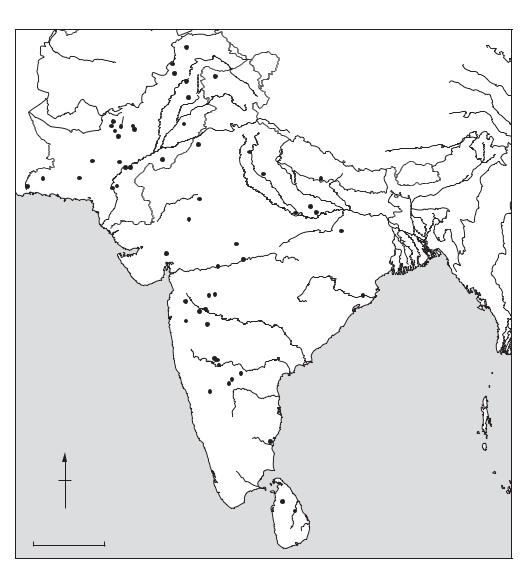
population movement occurred throughout prehistoric and historic periods, the South Asian past is best viewed as a complex mosaic, with considerable variation in ethnic groups, ways of life, and the pace and nature of cultural and technological change.
2.1 Prehistory. Knowledge of the South Asian Palaeolithic has been hampered by the paucity of primary sites and a reliance on surface finds and typological parallels to stone tool traditions in Africa and Europe to develop chronological frameworks. Recent work on important sites such as
ASIA 83
RIWAT, BHIMBETKA, SANGHAO, and sites in the
HUNSGI VALLEY of Karnataka, the Palaeolithic traditions of Rajasthan, and the Potwar Plateau of Pakistan is providing evidence for a long sequence of occupation from the Lower Palaeolithic through the Mesolithic period.
The transition to an agricultural economy occurred at widely different times in the different regions of South Asia. The earliest agricultural settlement is the site of MEHRGARH in western Pakistan, with domesticated sheep, goat, cattle, barley and wheat from the 7th millennium BC.
|
|
|
Loebanr |
|
|
|
|
|||
|
|
|
Sanghao |
|
|
|
|
|
|
|
|
|
|
Charsada |
Burzahom |
|
|
|
|||
|
PAKISTAN |
Taxila |
|
|
|
|||||
|
|
|
|
|
|
|
|
|||
|
Kili Ghul |
Rawalpindi |
|
|
|
|
||||
|
Pirak |
|
|
|
|
|
|
|
||
|
Muhmammad |
|
|
|
|
|
|
|
||
Damb Sadaat |
Sur Jangal |
Harappa |
|
|
|
|||||
|
|
|
|
|
||||||
|
Naushahro |
Dabarkot |
|
|
|
|
|
|
|
|
|
|
Mehrgarh |
|
|
Kalibangan |
Hastinapura |
|
|||
|
|
Mohenjo- |
|
|
|
|||||
Shahi |
Nal |
Daro |
Kot Diji Ganweriwala |
|
NEPAL |
|||||
Tump |
Kulli |
|
Rohri hills |
|
|
|
Atranjikhera |
Lumbini |
||
Sutkagen |
|
Amri |
Chanhu-Daro |
|
|
|
||||
|
|
|
|
|
|
|
||||
Dor |
|
|
|
|
|
|
Bagor |
|
Sarnath |
|
|
|
|
|
. |
|
|
|
|||
|
|
|
|
|
|
|
|
|
|
|
|
|
|
|
R |
|
|
|
|
|
Varanasi |
|
|
|
|
i |
|
|
|
|
|
|
|
|
|
u |
n |
|
Ahar |
|
Kausambi |
(Rajghat) |
|
|
|
|
|
|
|
|||||
|
|
|
L |
|
|
|
|
|
|
|
|
|
|
|
|
|
|
|
Bhimbbetka |
Bodhgaya |
|
|
|
|
Lothal |
|
|
|
|
|
||
|
|
|
|
|
Navdatoli |
Adamgarh |
|
|||
|
|
|
|
|
|
|
|
|
||
|
|
|
Nasik |
|
Ellora Ajanta |
|
Bhuvaneshvar |
|||
|
|
|
|
|
|
|
INDIA |
|||
|
|
|
|
Jorwe |
|
|
(Sisulpalgarh) |
|||
|
|
|
|
Daimabad |
|
|||||
|
|
|
|
|
|
|
|
|
||
|
|
|
Chandoli |
|
Inamgaon |
|
|
|||
|
|
|
|
|
|
|
|
|
||
|
|
|
|
|
|
|
Aihole |
|
|
|
|
|
|
|
|
Hunsgi |
|
|
|
||
|
|
|
|
|
|
|
Piklihal |
|
Utnur |
|
|
|
|
|
|
|
|
|
|
|
|
|
|
|
|
|
Brahmagiri |
Tekkalakota |
|
|||
|
|
|
|
|
|
|
Hallur |
|
|
|
N |
|
|
|
|
|
|
|
Arikamedu |
||
|
|
|
|
|
|
|
|
|
||
|
|
|
|
|
|
|
|
|
Anuradhapura |
|
|
|
|
|
|
|
|
|
|
Polonnaruva |
|
0 |
|
500 km |
|
|
|
|
|
|
|
|
Map 16 Asia, 2: South |
Some major archaeological sites in the region. |
|||||||||
84 ASIA
BURZAHOM in Kashmir contains domesticates from c.2900 BC; while in the southern Indian Deccan domesticated cattle are associated with the ASH MOUND sites of the 3rd millennium BC. In many areas, hunting and gathering communities persisted alongside and in interaction with agricultural and even urban settlements.
2.2. History. The recognition of the 3rd millennium urban settlements of the Indus Valley in the 1920s radically altered understandings of South Asian prehistory. Since then, more than 1000 sites of the Indus civilization have been identified, over an area of more than half a million sq km, and the Indus sequence has been refined into three main phases: the Early Indus (c.4000–2600 BC), the Mature or Urban Indus period (c.2600–1900 BC), and the Late Indus (1900–1300 BC); precise dates of these phases vary somewhat from region to region. Although the Mature Indus or Harappan period is best known for the large urban settlements of
MOHENJO-DARO, HARAPPA, and GANWERIWALA,
most sites of the Indus Civilization are small villages, towns and specialized production locales. Characteristic artefacts of the Mature Indus include standardized stone weights, copper tools, ceramic figurines and painted ceramic vessels, and steatite seals, inscribed with an, as yet, untranslated script.
The 2nd and early 1st millennia BC were characterized by the re-emergence of localized traditions in areas where Indus sites were known, and the expansion and development of copper using agricultural communities elsewhere throughout peninsular India. PIRAK in the Kachi Plain of Pakistan was a 9 ha settlement with evidence of considerable contact with Central Asia and Eastern Iran; in the Ganges Basin, the OCHRE COLOURED
POTTERY (1800–1400 BC) and PAINTED GREY
WARE (1300–600 BC) periods are the antecedents to the GANGES CIVILIZATION, the second period of South Asian state formation.
Contact with Central Asian pastoral nomads, and their movement into South Asia, significantly affected South Asian developments, especially in the north and the Ganges Basin. Although the traditional view of a massive Central Asian Aryan ‘invasion’ is not supported by archaeological data, it is also clear that developments in South Asia cannot be treated in isolation, and that population movements and broad inter-regional reaction were important to historical developments. South of the Ganges, agricultural settlements of the BANAS tradition (Rajasthan), and the Deccani MALWA (1800–1400 BC), and JORWE (1400–700 BC) are known, while in the south sites
and small agricultural settlements such as
TEKKALAKOTA are found.
In the early first millennium BC, iron appeared. In the northwest, cemetery sites of the GANDHARA are of this period, and the centres of CHARSADA and TAXILA arose; the impact of
Achaeminid, Parthian, Scythian, and Greek civilizations were also evident in this region. In southern India, the 1st millennium BC is characterized by the appearance of megalithic tombs, such as those from Brahmagiri.
In the Ganges River Basin, the GANGES CIVILIZATION emerged, first as a network of small competing city states centred at sites such as
KAUSAMBI, ATRANJIKHERA, HASTINAPURA,
RAJGHAT, Mathura and Noh. During this dynamic period the Buddha and Mahavira (the founder of JAINISM) preached and many of South Asia’s historic religious and cultural traditions emerged. In 324 BC, the Ganges region and much of India and Pakistan were united into a single polity, the MAURYAN empire, which lasted until 184 BC. Following the decline of the Mauryans, South Asian history is characterized by the rise and fall of countless historic states and empires, formed through cycles of conquest and collapse.
2.3 Archaeological research. The earliest archaeological work in south Asia was initiated by the British in the 18th century and formalized through the founding of the Asiatic Society in 1784 and the Archaeological Survey of India in 1854. In the 1920s the INDUZ CIVILIZATION was discovered and largescale excavations were conducted at HARAPPA, MOHENJO-DARO and related sites. Following independence in 1947, archaeological work in the different nation states of south Asia proceeded under the authority of national and local departments of archaeology and in university contexts. Research has been most intensive within India and Pakistan.
A considerable amount of descriptive data has been accumulated in the two centuries of archaeological research in South Asia; however, it is only within the last two to three decades that significant attempts have been made to synthesize these data into broader understandings of regional developments and cultural traditions.
D.P. Agrawal and D.K. Chakrabarti: Essays in Indian protohistory (Delhi, 1979); D.P. Agrawal: The archaeology of India (Copenhagen, 1982); B. and R. Allchin: The rise of civilization in India and Pakistan (Cambridge, 1982); G.L. Possehl, ed.: Harappan civilization (Delhi, 1982); K.A.R. Kennedy and G.L. Possehl, eds: Studies in the archaeology and palaeoanthropology of South Asia (New Delhi, 1984); B.B. Lal and S.P. Gupta, eds: Frontiers of the Indus