

A Dictionary of Archaeology
.pdfCivilization (Delhi, 1984); V.N. Misra and P. Bellwood, eds: Indo-Pacific prehistory (New Delhi, 1985); M.L. Kenoyer, ed.: Old problems and new perspectives in the archaeology of South Asia (Madison, 1989).
CS
3 Southeast Asia
The physical relief of the region of southeast Asia offers a sharp contrast between the floodplains of the Chao Phraya, Mekong and Red rivers and the intervening uplands. The climate is monsoonal, with a dry season which lasts from November to April, and rains which commence in May. The most significant environmental change in the Holocene involved the drowning of extensive continental shelves by a rising sea, and the formation of shorelines higher than the present sea level.
ASIA 85
3.1 Prehistory. The drowning of the continental shelves has prevented the consideration of maritime adaptation before 4000–5000 BC, when raised beaches with prehistoric settlements are encountered, but it is clear that the inland, forested uplands were occupied by small bands of transitory foragers. Numerous rock shelters are known, particularly in the karst uplands of northern Vietnam, and these are often ascribed to the Hoabinhian technocomplex. The material culture included flaked river cobbles and, with time, edgeground and polished adzeheads and pottery sherds. These sites have been dated from 11000 BC, and some late contexts in northern Thailand lasted into the 3rd millennium BC or even later. The material culture corresponds to that found in the lowest levels of thick coastal shell middens found on raised
Date |
Period |
Principal events and sites |
|
AD 1500 |
General |
The rise of states or mandalas in the lower Mekong valley, coastal Viet Nam, |
|
|
Northeast Thailand and Chao Phraya valley. Increased centralisation in court |
||
|
period |
centres, Indian inspired religion, statecraft and the Sanskrit language. |
|
|
D |
Angkorian Mandala founded in AD 802 and attracted widespread loyalty. Han |
|
AD 200 |
|
Chinese set up commanderies in Bac Bo. |
|
|
|
|
|
|
General |
Iron-working, centralisation and formation of chiefdoms. Initial contact with |
|
|
Indian traders and Han Chinese armies and increased exchange, social |
||
|
period |
ranking and agriculture. Specialist bronze-workers produce ceremonial |
|
|
C |
drinking vessels, decorative body plaques, bowls and great decorated drums. |
|
500 BC |
|
Chiefly burials in boat coffins. |
|
|
|
|
|
|
General |
Bronze-working spread among autonomous lowland communities. Ores |
|
|
mined in hills, ingots traded and implements cast in lowlands. Increase in |
||
2000 – |
period |
ranking within small communities. Some family groups had high rank signified |
|
B |
by jewellery and bronze implements. Subsistence wide-ranging and included |
||
500 BC |
|||
|
rice which was probably cultivated. |
||
|
|
||
|
|
|
|
|
General |
Settlement expansion into the tributary streams of the Khorat plateau, middle |
|
|
country of Bac Bo, the Tonle Sap plains, margins of the Mekong delta and |
||
|
period |
||
|
Chao Phraya valley. Settlements small, and social organisation weakly |
||
|
A |
||
|
ranked. Stone implements and shell were exchanged between communities |
||
|
|
||
3000 BC |
|
which probably cultivated rice in swamp margins. |
|
|
|
|
|
|
Coastal |
Sea level rose sharply from about 7000-4000 BC; probably drowned coastal |
|
|
settlements. At 4000 BC, sea level stabilised at a higher level than today. |
||
|
Settlement |
||
|
Evidence for rich sedentary coastal settlement involving ranking, exchange |
||
|
|
||
5000 – |
|
and elaborate mortuary ritual at Khok Phanom Di. Pollen evidence for |
|
|
settlement by 4700 BC. Marine resources important, rice consumed. Latter |
||
1500 BC |
|
||
|
may have been harvested from natural stands in freshwater swampland. |
||
|
|
||
|
|
|
|
|
Early |
Sea level began much lower than today, rose to about 3m higher than at |
|
|
present. Former coastal settlements now drowned under sea. Main surviving |
||
|
Hunter- |
||
|
sites inland rock shelters. Limited range of stone tools, wooden implements |
||
|
Gatherers |
||
|
for hunting and gathering probably important. Small, mobile groups collected |
||
|
|
||
10,000 BC |
|
wild plants and shellfish. Evidence for hunting, fishing and trapping. |
|
|
|
|
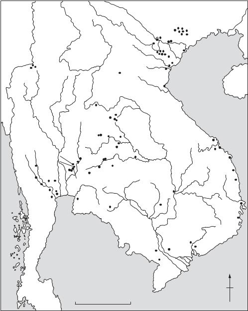
Table 9 Asia, 3: Southeast Chronology of Southeast Asia.
86 ASIA
beaches in Vietnam. These midden sites, which have been assigned to several regional cultures (Ha Van Tan 1980) can be in excess of 10 m deep, and sometimes contain inhumation cemeteries. Due to their rich material culture, which includes pottery, polished stone implements and a stone and bone
industry, they are often referred to as a coastal Neolithic, but there is as yet no biological evidence for agriculture.
The earliest evidence for rice cultivation within village communities belongs to the 3rd millennium BC, when settlements were established in the
|
|
|
|
|
|
|
|
|
Bac Son Sites |
|
|
|
|
|
|
|
|
|
|
|
Phung Nguyen Son Vi |
|
|
|
|
|
|
|
|
|
|
|
Go Mun |
Dong Dau |
|
|
|
|
|
|
|
|
|
|
Co Loa |
|
|
|
|
|
|
|
|
|
|
|
|
|
|
|
|
|
|
|
|
|
|
|
|
Viet Khe |
|
|
|
|
|
|
|
|
|
|
Hoa Binh sites |
Chau Can |
|
Spirit Cave |
Banyan Valley Cave |
|
|
|
|
|
Bim Son |
|
|||
|
Steep Cliff Cave |
|
|
|
|
|
|
Lach Truong |
|
||
|
|
|
|
|
|
Dong Son |
|
||||
|
|
|
|
|
|
|
|
Ban Ang |
|
|
|
|
|
|
|
|
|
|
|
|
|
Quynh Van |
|
|
|
|
|
|
|
Phu Lon |
|
|
|
|
|
|
|
|
|
|
|
Ban Chiang |
|
|
|
||
|
|
|
|
|
Ban Phak Top |
Ban Muang |
|
|
|||
|
|
|
|
|
|
Ban Na Di |
|
|
|||
|
|
|
|
|
|
Phruk |
|
|
|||
|
|
|
|
|
|
|
|
|
|
|
|
|
|
|
|
|
Non Nok Tha |
|
Non |
|
|
|
|
|
|
|
|
|
|
Chai |
Muang Fa Daet |
|
|
||
|
|
|
|
Non Nong Chik |
|
|
Tam My |
|
|||
|
|
|
|
|
|
|
|
||||
|
|
|
|
|
|
|
|
|
|
|
|
|
|
|
|
|
|
Ban Kho Noi |
Ban Chiang Hian |
Mi Son |
Tra Kieu |
||
|
|
|
|
|
|
|
|
||||
|
|
Sab Champa |
Si Thep |
Ban |
Phimai |
Non Dua |
Chau Xa |
||||
|
|
Tamyae |
|
||||||||
|
|
Khao Wong |
|
|
|
|
|
|
|
||
|
|
|
Khok Charoen |
|
|
|
|
||||
|
Ongbah |
Prachan |
|
|
Thamen Chai |
|
|
||||
|
Lopburi |
|
|
|
|
|
|||||
|
|
|
|
Muang Sima |
Sa Huynh |
||||||
|
|
Ban Tha Kae |
|
||||||||
|
Sai Yok |
|
Khao Chan Ngam |
|
|
||||||
|
|
|
|
|
|
|
|||||
|
Ban Don Ta Phet |
U Thong |
Chansen |
|
|
|
|
Caban |
|||
|
Ban Kao |
|
|
|
|
|
|
|
|
||
|
Nakhon Pathom |
|
|
|
|
|
|
||||
|
Pong Tuk |
|
|
|
Thala Borivat |
|
|||||
|
|
|
|
|
|
|
|
||||
|
|
Khok Phlap |
|
|
|
|
|
|
|||
|
|
|
|
|
|
|
|
|
|
||
|
|
Ku Bua |
|
|
Khok Phanom Di |
|
|
|
|||
|
|
|
|
|
|
|
|
||||
|
|
|
|
|
|
|
|
|
Isanapura |
|
Thanh Ho |
|
|
|
|
|
|
|
|
Laang Spean |
|
|
|
|
|
|
|
|
|
|
|
|
|
|
Po Nagar |
|
|
|
|
|
Gulf of |
|
|
|
|
Doc Chua |
|
|
|
|
|
|
Siam |
|
|
|
Angkor Borei |
Hang Gon |
|
|
|
|
|
|
|
|
|
|
Prasat Pram Loven |
|
|
|
|
|
|
|
|
|
|
|
|
|
|
|
|
|
|
|
|
|
|
|
Oc Eo |
|
|
|
|
|
|
|
|
|
|
|
|
|
N |
|
|
|
|
|
|
|
|
|
|
South China |
|
|
|
|
|
|
0 |
|
|
|
300 km |
Sea |
|
Map 17 |
Asia, 3: Southeast |
Major archaeological sites in the region. |
|
|
|||||||
tributary stream valleys of the major rivers. Over 50 sites of the PHUNG NGUYEN culture above the confluence of the Red and Black rivers in Vietnam have been identified. In northeast Thailand, there are such early contexts at BAN CHIANG and BAN PHAK TOP, while several sites are known in central Thailand, for example BAN KAO, Non Pa Wai and KHOK PHANOM DI. All incorporated a sophisticated ceramic industry, inhumation burials and grave goods which include pottery vessels and jewellery often exotic to the region. A widespread feature was the decoration of pottery with parallel incised lines infilled with impressions. Rice was often used as a ceramic temper, but it is not possible to deduce whether such chaff was from a wild or cultivated variety. The only firm evidence for the latter comes from Khok Phanom Di, an estuarine site with a mortuary sequence revealing about 20 successive generations of the same family groups. The associated grave offerings suggest that status was obtained through personal achievement rather than kinship.
By the mid-2nd millennium BC, copper-based metallurgy was widespread. Southeast Asia is rich in copper, tin and lead, and two mining complexes in the Khao Wong Prachan valley of central Thailand and the PHU LON hill in northeast Thailand have been examined. The earliest mining and smelting activity at both has been dated to about 1500 BC. At Khao Wong Prachan the ores contain significant quantities of arsenic, and tin was not used. The smelting sites there reveal the production of circular ingots, as well as socketed axes and projectile points. Away from the ore sources, there are several village sites within which bronze socketed axes, spearheads and arrowheads were cast in bivalve clay or sandstone moulds, while bracelets were cast using the lost-wax technique.
Until the mid-1st millennium BC, metallurgy was undertaken in small-scale enterprises, perhaps even as a dry season activity. Copper and bronze artefacts were included as grave offerings alongside stone, ivory, ceramic and shell items. But from about 500 BC, a number of major cultural changes took place. In the Khao Wong Prachan valley, there is evidence for iron smelting and forging. Use of this metal spread rapidly. Indian mercantile expansion led to a two-way exchange, particularly with strategically placed coastal or riverine communities, such as BAN DON TA PHET. Bronze bowls, ladles, decorative plaques, and above all drums, reveal the establishment of specialized workshops. The DONG SON CULTURE in northern Vietnam, which best exemplifies these changes, became increasingly exposed to Chinese expansion, and by the 1st century AD it had been incorporated into the Han empire.
ASIA 87
The rest of mainland Southeast Asia, however, saw the development of indigenous states which drew heavily on Indian religious and political notions of leadership and statehood. These influences involved Hinduism and Buddhism. The former was particularly popular in Cambodia, and the latter in central Thailand where early indications of contact with India are known from Ban Don Tha Phet and Chausen. From about 200 AD, such polities are known from the lower Mekong area, where they have been subsumed under the name FUNAN. The best-known site is OC EO, a rectangular area of about 450 ha which lies at the centre of a web of canals linking it with other sites. Subsequent polities developed in central Cambodia (Vickery 1986), and inscriptions in Sanskrit and archaic Khmer provide the names of the overlords and stress the worship of Siva. Analagous polities (Higham 1989: 297–306) are found on the coast of Vietnam, where Cham was spoken. This is an Austronesian language, probably brought from island Southeast Asia in the late prehistoric period.
In Central Thailand, the polities characterized by the DVARAVATI CULTURE developed, and here the language spoken was Mon, a close relative of Khmer. The most successful and powerful state, however, was established at ANGKOR on the northern shore of the Tonle Sap (Great Lake) of Central Cambodia in the early 9th century AD. The rulers, responsible for such monuments as Angkor Wat and the Bayon (see ANGKOR), exerted their influence over much of the mainland until the fifteenth century AD, when Angkor was sacked by an invading Thai army.
In 1983, Bayard proposed four successive cultural periods to describe the prehistoric sequence in northeast Thailand. General Period A antedated metallurgy, and saw weak social ranking. Period B involved the use of copper-based metallurgy associated with increased social ranking, but still within small, autonomous communities. The next period witnessed the use of iron as well as bronze, and the development of chiefdoms based on large, moated centres. Finally, General Period D involved the development of states. This scheme has since been more widely applied to other parts of lowland Southeast Asia. The dating of these phases is tentatively: A: 21500–1500 BC; B: 1500–600 BC; C: 600 BC–AD 200; and D: from AD 200. The scheme has been applied more widely by Charles Higham (1989).
3.2 Archaeological research. The archaeology of mainland Southeast Asia effectively began after the incorporation of Vietnam, Cambodia and Laos into the French colonial empire, and was stimulated by
88 ASIA
the foundation of the École Française d’Extrême Orient in 1898. Early excavations were undertaken under the auspices of the French colonial administration, with particular encouragement from the École Française and the Geological Service of IndoChina. Coastal shell-midden sites, inland rock shelters, and large settlements, such as Dong Son, were used to establish an archaeological sequence, although most energy was directed to the large historic sites, particularly Angkor.
Such efforts were effectively terminated by the Second World War and the Vietnamese–French conflict. From the 1960s, Western archaeologists began research in Thailand, and the Vietnamese inaugurated their own programme. The former introduced the full range of Western methodology and interpretative structures, while the latter largely remained within the pre-war French paradigm, with some Soviet influence.
O.R.T. Jause: Archaeological research in Indo-China III: The ancient dwelling site of Dong-S’on (Thanh-Hoa, Annam) (Cambridge, MA, 1958); Nguyen Phuc Long: ‘Les nouvelles recherches archéologiques au Vietnam’, Arts Asiatiques 31 (1975) [entire issue]; Ha Van Tan: ‘Nouvelles recherches préhistoriques et protohistoriques au Viet Nam’, BEFEO 68 (1980), 113–54; J.C. White: Ban Chiang (Philadelphia, 1982); D.T. Bayard: ‘Rank and wealth at Non Nok Tha’, Southeast Asian archaeology at the XV Pacific Science Congress, ed. D.T. Bayard (Otago, 1984), 87–128; ––––: ‘A tentative regional phase chronology for northeast Thailand’, Southeast Asian Archaeology at the XV Pacific Science Congress, ed. D.T. Bayard (Otago, 1984), 161–8; M. Vickery: ‘Some remarks on early state formation in Cambodia’, Southeast Asia in the 9th to 14th centuries, ed. D.G. Marr and A.C. Milner (Canberra and Singapore, 1986), 95–115; I.C. Glover: Early trade between India and Southeast Asia (Hull, 1989); C.F.W. Higham: The archaeology of mainland Southeast Asia
(Cambridge, 1989); ––––: Khok Phanom Di (Fort Worth, 1993).
CH
Askut Island Upper Nubian site at the southern tip of LAKE NASSER, primarily consisting of an Egyptian fortress of the Middle Kingdom (c.2040–1640 BC) and a Nubian settlement of the Christian period (c.AD 550–1500), both excavated by the University of California during the early 1960s. Since a high percentage of the interior of the 12th-dynasty fortress is occupied by the remains of mud-brick granaries, it has been suggested that Askut may have been an emergency supply depot for the Egyptian army rather than a straightforward garrison.
A. Badawy: ‘Preliminary report on the excavations by the University of California at Askut’, Kush 12 (1964), 47–53;
––––: ‘Archaeological problems relating to the Egyptian
fortress at Askut’, JARCE 5 (1966), 23–7; S. Tyson Smith:
Askut in Nubia: the economics and ideology of Egyptian imperialism in the second millennium BC (London, 1995).
IS
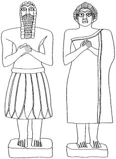
Asmar, Tell (anc. Eshnunna) Site of a SUMERIAN city-state to the north-east of modern Baghdad, Iraq. The cult-centre at the site has yielded an extraordinary series of religious statues (see figure 5). See for further discussion.
Asokrochona Site of a Stone Age lithic workshop near the coast east of Accra, Ghana. The site was located by Oliver Davies in 1958 and excavated by S.E. Nygaard and M.R. Talbot, and by B.W. Andah, in 1972–4. The principal archaeological horizon occurs on or at the top of what Nygaard and Talbot call an ironstone gravel of well-rounded laterite fragments (the Asokrochona Formation) said to have been formed under semi-arid conditions, beneath red aeolian sand (the Nungua Formation) which contains a few Middle Stone Age artefacts. The main archaeological occurrence has
Figure 5 Asmar, Tell Limestone statues of worshippers, 0.34 m high, with eyeballs of inlaid shell, found buried in the shrine of an Early Dynastic temple at Tell Asmar. Source: J. Black and A. Green: Gods, demons and symbols of ancient Mesopotamia: an illustrated dictionary (BMP, 1992), fig. 1.
commonly been regarded as SANGOAN (although local names for it have also been proposed) and it is the most extensively excavated and most fully published site representative of this entity in West Africa. There are over 20,000 artefacts, of which around 2500 are tools and cores, the remainder consisting principally of flakes, manuports, chips and chunks. The tools include a few handaxes, picks, and core-axes, as well as other heavy and light duty components, mainly of quartz and quartzite. There is no fauna, and the dating of the site remains hypothetical.
O.Davies: The Quaternary in the Coastlands of Guinea
(Glasgow, 1964); S.E. Nygaard and M.R. Talbot: ‘Interim report on excavation at Asokrochona, Ghana’, WAJA 6 (1976), 13–19; B.W. Andah: ‘The early palaeolithic in West Africa: the case of Asokrochona coastal region of Accra, Ghana’, WAJA 9 (1979), 47–85; S.E. Nygaard and M.R. Talbot: ‘Stone age archaeology and environment on the southern Accra plains, Ghana’, NAR 17 (1984), 19–38;
P.Allsworth-Jones: ‘The earliest human settlement in West Africa and the Sahara’, WAJA 17 (1987), 87–128.
PA-J
assemblage Set of artefacts, not necessarily of the same type, recovered from a specific archaeological context. Distinct groups of artefacts (for instance, flints that have been manufactured using a particular technique) from different assemblages may be categorized as an INDUSTRY. Distinctive assemblages or industries whch recur in different contexts are often taken as indicators of a specific culture; however, archaeologists have become increasingly wary of assuming that distinctive assemblages of material culture necessarily indicate wider linguistic and social groupings (see CULTURE
HISTORY).
The term ‘assemblage’ is sometimes used more loosely to describe artefacts grouped together for the purposes of argument or analysis, or in a particular collection.
RJA
Assiut see ASYUT
associated, association see CONTINGENCY
TABLE
Assur see ASSYRIA
Assyria, Assyrians Semitic state and people whose origins perhaps lay in the desert surrounding the upper Tigris; they first appeared in northern Mesopotamia in the 3rd millennium BC, and their name derives from the city of Assur which they established in northern Mesopotamia. The tell-site
ASSYRIA, ASSYRIANS 89
of Qalat Shergat (ancient Assur), located beside the Tigris, midway between modern Mosul and Baghdad, appears to date back at least to the Early Dynastic II period (c.2750–2600 BC), but it remained a relatively obscure settlement until the 19th century BC, when colonies of merchants from Assur began to establish profitable colonies beside some of the major Anatolian cities, hundreds of miles to the north of Assur itself (see KÜLTEPE). Under the successful AMORITE ruler Shamshi Adad I (c.1813–1781 BC) an Assyrian empire was established, with its capital initially at Shubat-Enlil (Tell Leilan) and later at Assur. The political machinations and administrative structure of the Old Assyrian empire are recorded in an archive of more than 20,000 cuneiform tablets excavated from the Syrian city of MARI. For over 400 years after the rise of the Babylonian ruler Hammurabi (who sacked Mari in 1757 BC), the Assyrians were overshadowed by BABYLON to the south and MITANNI to the north, but eventually – under Ashuruballit I (c.1363–1328 BC) – they regained their independence. It was, however, not until the late 10th century BC that the Assyrians regained control of northern Mesopotamia in the reign of Adad-Nirari II (c.911–891 BC). The Late Assyrian empire, which was centred on the three major cities of Kalhu (NIMRUD), NINEVEH (Tell Kuyunjik) and DurSharrukin (KHORSABAD), expanded rapidly over an area stetching from modern Iran to the Mediterranean. At Maltaï, about 60 km from Mosul, there are three rock-carved reliefs of the reign of Sennacherib (c. 704–681 BC) depicting processions of Assyrian deities (Bachmann 1927).
Although Esarhaddon (c.680–669 BC) succeeded in conquering Egypt, the Assyrian heartland was under increasing attack from the Medes and the Babylonians; ultimately, in 612 BC the whole empire crumbled and Nineveh itself was destroyed. For a few years after the sack of Nineveh the Assyrians appear to have fought a rearguard action from the Syrian city of Harran (Sultantepe), which had previously been an important commercial centre of the empire, but overall control of Mesopotamia had by then been irretrievably ceded to the neo-Babylonian rulers.
D. Oates: Studies in the ancient history of northern Iraq
(London, 1968), 19–41 [early development of Assyria]; W. Andrae: Das wiedererstandene Assur, 2nd edn (Munich, 1977) [the German excavations at Assur, 1903–14]; J. Reade: Assyrian sculpture (London, 1983); J. Curtis and J. Reade, eds: Art and empire: treasures from Assyria in the British Museum (London, 1995).
IS
90 ASTT
ASTt see ARCTIC SMALL TOOL TRADITION
Asturian Mesolithic stone and bone industry linked to the shell-midden sites or concheros of northern Spain. The Asturian lithic industry is crude and has a high proportion of heavy duty tools, including a unifacial pick; compared to the AZILIAN it exhibits a relatively high proportion of serrated artefacts and a relatively low proportion of backed bladelets. The Asturian was identified as a distinct ‘culture’ after excavations by the Count of Vega del Sella at the cave of El Penicial (Asturias) in 1914. Strauss and Clark have more recently argued against this, suggesting that the concheros should be viewed as the middens of specialized exploitation sites which operated within an integrated AzilianAsturian Mesolithic economy. However, the contemporaneity of the Azilian and Asturian is not yet quite proven, and González Morales has criticized this FUNCTIONALIST interpretation.
G.A. Clark: ‘Site functional complementarity in the Mesolithic of northern Spain’, The mesolithic in Europe, Papers presented at the Third International Symposium, Edinburgh, ed. Clive Bonsall (Edinburgh, 1985), 589–603; M.R. González Morales: ‘Asturian resource exploitation: recent perspectives’, The mesolithic in Europe; L.G. Strauss: Iberia before the Iberians (Albuquerque, 1992), 217–29.
RJA
Asuka District in Nara prefecture, Japan, which was the centre of the introduction of Buddhism from the Asian continent in the 6th–7th centuries AD. Early palace sites and temples, including the site of Asuka-dera, the first Buddhist temple in Japan and Kawahara-dera, are now protected as part of a special historical district. The Fujiwara Palace site has also been excavated. The region was the centre of the Ritsuryo state until the capital was moved to HEIJO in AD 710.
K. Tsuboi: ‘The excavation of ancient palaces and capitals’, Acta Asiatica 63 (1992), 87–98.
SK
Aswad, Tell see ACERAMIC NEOLITHIC
Aswan (anc. Swnt, Syene) Pharaonic site in Upper Egypt at the northern end of LAKE NASSER. On the eastern bank of the Nile are the town, temples and granite quarries of Aswan itself, while the Old and Middle Kingdom rock-cut tombs of Qubbet el-Hawa are situated on the opposite bank. In the centre of the Nile at Aswan are the town and temples of the island of Elephantine. Apart from two small Ptolemaic and Roman temples there are
few surviving remains of the city of Aswan itself since the area has continued to be occupied up to modern times. The tombs of Qubbet el-Hawa, which date mainly to the Old and Middle Kingdoms (c.2649–1640 BC), contain important reliefs and inscriptions, including the ‘funerary biographies’ of important officials such as the 6thdynasty provincial governor Harkhuf. Elephantine has been excavated by a German team since the 1970s (Kaiser et al. 1972–95). It has proved possible to trace the gradual enlargement of the town of Elephantine from the early Dynastic period to the Roman period (c.2900 BC–AD 395), thus contributing to the understanding of processes of urbanization in pharaonic Egypt.
E. Edel: Die Felsengräber der Qubbet el-Hawa bei Assuan
(Wiesbaden, 1967–); W. Kaiser, G. Dreyer and S. Seidlmayer: Regular preliminary reports on Elephantine excavations in MDAIK 28–51 (1972–95); E. Bresciani and S. Pernigotti: Assuan: il tempio tolemaico di Isi. I blocchi decorati e iscritti (Pisa, 1978).
IS
Aswan High Dam |
see LAKE NASSER |
Asyut (anc. Djawty) |
Site in Egypt, roughly mid- |
way between Cairo and Aswan, which was the ancient capital of the 13th Upper Egyptian nome (province), where, according to many surviving texts, the principal cult-centre of the wolf-god Wepwawet was located. The archaeological remains consist primarily of the rock tombs of the local elite, dating from the 9th dynasty to the Ramessid period (c.2134–1070 BC). The so-called ‘biographical’ inscriptions on the walls of the tombs of the 1st Intermediate Period and Middle Kingdom (c.2134–1640 BC) provide historical information on the struggle between the rulers of HERAKLEOPOLIS
MAGNA and THEBES.
F.L. Griffith: The inscriptions of Siut and Der Rifeh
(London, 1889); G.A. Reisner, ‘The tomb of Hepzefa, nomarch of Siñt’, JEA 5 (1919), 79–98; H. Thompson, A family archive from Siut (Oxford, 1934).
IS
Atchana, Tell (Açana; anc. Alalakh) Settlement mound by the River Orontes in northwestern Syria, which was the site of Alalakh, the capital of a small kingdom in the 2nd millennium BC. It appears to have particularly prospered in c.1550–1400 BC, when it was one of the westernmost vassals of the HURRIAN kingdom of MITANNI. It was excavated by Leonard Woolley in 1937–9 and 1946–9, revealing an unusual temple of the 24th century BC, and the palaces of two of its rulers, Yarim-Lim (c.1750 BC)
and Niqmepa (c.1500 BC), the former including a BIT-HILANI. Woolley also explored the neighbouring port of el-Mina, at the mouth of the Orontes, which was used primarily during the Achaemenid period (c.538–331 BC).
The site of Alalakh consisted of 17 strata in all, stretching from the Chalcolithic period (c.3500 BC) until the early 12th century BC, when it may have been destroyed by the SEA PEOPLES. Stratum VII, dating to the 18th century BC, when the city was part of the AMORITE kingdom of Yamhad, included a cache of cuneiform tablets, inscribed in Akkadian, which first enabled Woolley to identify the site as Alalakh. Another archive, discovered in stratum IV and dating to the 15th and 16th centuries BC, has shed a great deal of light on the society and administration of Mitanni and its relations with the HITTITES, providing a useful comparison with the slightly later diplomatic correspondence from EL-AMARNA (Wiseman 1953). Sidney Smith (1940) was able to use the Alalakh stratigraphy and textual evidence to construct a general chronology for the northern Levant in the 2nd millennium BC.
A group of carved ivory objects excavated from the same stratum show the same mixture of external influences as the wall-paintings at NUZI, one of the easternmost cities of Mitanni. The style of palace architecture at Alalakh, both before and after the Hurrian domination, is part of a local tradition, using stone foundations, basalt orthostats and a great deal of plaster-clad timber. The maintenance of different local architectural traditions at Alalakh and Nuzi suggests that there was no overall Mitannian palatial style.
S. Smith: Alalakh and chronology (London, 1940); D.J. Wiseman: The Alalakh tablets (London, 1953); C.L. Woolley: Alalakh: an account of the excavations at Tell Atchana in the Hatay, 1937–49 (London, 1955).
IS
Aterian Palaeolithic industrial complex, named by Maurice Reygasse in the 1920s, after the site of Bir el-Ater in the Oued Djebbana, eastern Algeria, at first on the basis of a distinctive ‘fossile directeur’, the tanged point. The industry as a whole was later defined by Jacques Tixier as a LEVALLOIS facies of the MOUSTERIAN, in which tanged tools of various kinds (not only points) constituted up to one quarter of the retouched artefacts. François Bordes observed that the many technological and typological elements common to both Mousterian and Aterian suggested that the second derived from the first. This is supported by stratigraphic superposition of these industries at Témara, northwestern Morocco, and at Taforalt and Rhafas,
ATERIAN 91
eastern Morocco. Apart from the Maghreb, the Aterian has a very wide extension in North Africa and the Sahara, as far as Cyrenaica and the Egyptian desert in the east (HAUA FTEAH and the oases of Kharga and Bir Tarfawi) and the TAOUDENNI and Northern Chad basins in the south (including
ADRAR BOUS).
J.D. Clark suggests that within the Aterian as a whole various ‘culture areas’ or ‘traditions’ may be distinguished, characterized by distinctive artefact forms, such as bifacially worked foliate points, which are particularly numerous southeast of the Hoggar mountains. Tanged points (implying hafting) in his view constitute the first unequivocal evidence for simple compound tools in the palaeolithic record. Chronologically, the Aterian in the Maghreb is commonly regarded as falling in the interval 40,000–20,000 years ago, and there are a number of finite radiocarbon dates in this range; as well as OSL (optically stimulated luminescence) and TL (thermoluminescence) dates now available from Chaperon Rouge in northwestern Morocco indicative of an occupation at 28,200 ± 3300 BP. Nevertheless, minimum or infinite radiocarbon dates for Taforalt suggest that the Aterian there may be >40,000 years old, and the finding of Aterian artefacts in or above Tyrrhenian beach deposits in the vicinity of Oran, western Algeria, would be consonant with this.
At HAUA FTEAH, Charles McBurney detected possibly tanged pieces and a ‘strong hint of Aterian affinities’ in layers XXXII–XXXI, corresponding to a period >43,400 BP, and at Bir Tarfawi the tanged pieces originally identified as Aterian are likely to date to the end of the sequence around 60,000 years ago. The Aterian in the Sahara is generally considered to be relatively late, corresponding to the Upper Ghazalian humid period c.30–20,000 years ago. An upper limit is provided by a date of 18,600 ± 400 BP from Ekouloulef in the Air mountains. At Adrar Bous and Bilma the Aterian is preceded by Middle Stone Age industries which Tillet places in the Lower Ghazalian humid period c.40–35,000 years ago; while ‘probably comparable to the Mousterian in the Maghreb’ such industries in his view might represent a local origin for the Aterian and constitute its early phase in this area. The Aterian is associated with anatomically modern man at DAR-ES-SOLTANE II and three other sites on the Moroccan coast.
J. Tixier: ‘Procédés d’analyse et questions de terminologie conçernant l’ étude des ensembles industriels du paléolithique récent et de l’epipaléolithique dans l’Afrique du Nord-ouest’, Background to evolution in Africa, ed. W.W. Bishop and J.D. Clark (Chicago, 1967), 771–820;
92 ATERIAN
C.R. Ferring: ‘The Aterian in North African prehistory’,
Problems in Prehistory: North Africa and the Levant, ed. F. Wendorf and A.E. Marks (Dallas, 1975), 113–26; F. Bordes: ‘Moustérien et Atérien’, Quaternaria 19 (1976–7), 19–34; J.D. Clark: ‘Human populations and cultural adaptations in the Sahara and Nile during prehistoric times’, The Sahara and the Nile, ed. M.A.J. Williams and H. Faure (Rotterdam, 1980), 527–82; A.E. Close: ‘Current research and recent radiocarbon dates from Northern Africa’, JAH 21 (1980), 145–67; G. Delibrias et al.: ‘Gif natural radiocarbon measurements IX’, Radiocarbon 24 (1982), 291–343; T. Tillet: ‘The palaeolithic and its environment in the northern part of the Chad basin’, AAR 3 (1985), 163–77; A. Debénath et al.: ‘Stratigraphie, habitat, typologie et devenir de l’Atérien marocain: données récentes’, L’Anthropologie 90 (1986), 233–46; L. Wengler: ‘Position géochronologique et modalités du passage Moustérien–Atérien en Afrique du Nord, L’exemple de la grotte du Rhafas au Maroc oriental’, CRASP, Série II 303 (1986), 1153–6; J.P. Tixier et al.: ‘Nouvelles données sur la situation chronologique de l’Atérien du Maroc et leurs implications’, CRASP, Série II, 307 (1988), 827–32; F. Wendorf et al.: Egypt during the Last Interglacial: the Middle Palaeolithic of Bir Tarfawi and Bir Sahara East
(New York and London, 1993).
PA-J
Atestine culture see ESTE
atomic absorption spectrophotometry (AAS) Quantitative technique of chemical analysis applicable to metals, ceramics, glass and lithics for major, minor and trace element analysis. The technique relies on the principle that electron energy level changes in atoms may be stimulated by the absorption of light at element-specific wavelengths. A small sample is required, typically 10 mg when applied to metals, and usually this must be in solution.
The basic instrument consists of a light source emitting the spectrum for the element being measured (e.g. copper), a flame through which the light is directed and sample atomized, and a monochromator measuring the intensity of light transmitted through the flame at a specific wavelength characteristic of the element. Solutions are introduced into the flame via a nebulizer with a capillary uptake tube. While the sample solution is sprayed into the flame, any atoms of the element being measured will respond by absorbing some of the light from the lamp. The absorbance recorded is proportional to the quantity of the element in the flame and hence in the solution. Standard solutions of known concentration are measured initially to calibrate for each element.
The technique is sequential for each element, although one solution is normally used to measure
all elements in a given sample. The precision and accuracy are high (1–2% for major components) and a very wide range of elements can be quantified but this does not include certain non-metals such as, for example, oxygen, carbon, nitrogen or chlorine.
The sensitivity may be increased, and detection limits lowered to the ultra-trace level, by using electrothermal instead of flame atomization. This uses a graphite tube, into which the sample is injected and through which the light is directed, that is electrically heated to about 3000°C which atomizes the sample and generates a transient absorption signal.
AAS – first applied in the early 1970s – has been used extensively to analyse a wide range of archaeological materials such as copper-based alloys of all periods, flint, slag, pottery and glass. Applications include artefact characterization, technology and provenance investigations. AAS is beginning to be challenged by
PLASMA-ATOMIC EMISSION SPECTROMETRY) as an
alternative technique for chemical analysis of sampleable inorganic materials.
M.J. Hughes et al.: ‘Atomic absorption techniques in archaeology’, Archaeometry 18 (1976), 19–37; W.J. Price:
Spectrochemical analysis by atomic absorption (Wiley, 1979).
MC
Atranjikhera Multi-period site on the Kali Nanga tributary of the Ganges in Uttar Pradesh, India, consisting of a single mound (about 40 ha in area). Excavations in the 1960s and 1970s showed that there were seven phases of the site, the first four
of which – OCHRE COLOURED POTTERY, BLACK AND RED WARE, PAINTED GREY WARE and
NORTHERN BLACK POLISHED WARE – date to late
prehistoric and early historic periods (c.1800–50 BC). Twenty-three coins of the Nanda, MAURYAN and Sunga dynasties were recovered from the levels dating to the Northern Black Polished Ware period (c.600–50 BC), when the site reached its maximum extent, with densely packed mud-brick and fired brick buildings and a massive defensive wall. See
also GANGES CIVILIZATION.
R.C. Gaur: Excavations at Atranjikhera (Delhi, 1983).
CS
Atrib, Tell (anc. Hwt-Heryib, Athribis) Egyptian settlement site located in the central Delta region near the modern town of Benha, 40 km north of Cairo. The principal surviving features of Tell Atrib are a temple dating to the time of Amasis (c.570–526 BC), the tomb of Queen Takhut (c.590 BC) and extensive urban, religious and funerary remains of the Greco-Roman period (c.332 BC–AD
395). The site as a whole has been severely damaged by the activities of sabbakhin (farmers plundering ancient mud-brick for use as fertilizer), one of whom discovered a large cache of Late Period (c.712–332 BC) jewellery in 1924. During the 1980s and 1990s a team of Polish archaeologists have concentrated on the excavation of the Greco-Roman town.
A. Rowe, ‘Short report on the excavation of the Institute of Archaeology Liverpool at Athribis (Tell Atrib)’, ASAE 38 (1938), 523–32; P. Vernus: Athribis (Cairo, 1978); K. Mysliwiec and T. Herbich: ‘Polish archaeological activities at Tell Atrib in 1985’, The Archaeology of the Nile Delta: problems and priorities, ed. E.C.M. van den Brink (Amsterdam, 1988), 177–203.
IS
attribute/attribute state see VARIABLE
auger electron spectroscopy (AES) Qualitative and quantitative non-destructive surface technique particularly suited to light-element chemical analysis. In principle, the technique is related to energy dispersive X-ray analysis using a scanning electron microscope (SEM EDX). Electron excitation causes ionization of atoms in the specimen but, instead of the re-arrangement which would cause a fluorescent X-ray photon to be emitted, there is an internal conversion which results in the release of low-energy electrons. The electron energy is specific to a particular element and is subject to small changes due to chemical effects, specifically the valance state of the element. The technique is therefore capable of detecting the presence of compounds, such as oxides, on metal surfaces and has been applied to the analysis of patinas. The surface layer analysed is of the order of 10–2 μm in depth.
M. Polak et al.: ‘Auger electron spectroscopy applied to archaeological artefacts’, Archaeometry 25 (1983), 59–67.
MC
Aurignacian Early Upper Palaeolithic industry (c.38000–28000 BC) that presents a full blade technology and a wide range of tools, including carinate (thick) scrapers, burins, endscrapers, and blades with a distinctive ‘scalar’ (or ‘Aurignacian’) retouch around their margins. The Aurignacian, named after the Aurignac shelter in the French Pyrenees, is also characterized by a rich bone industry that includes bone points and awls (see also MOBILIARY ART). It seems highly probable, if not quite certain, that Aurignacian assemblages were produced solely by Homo sapiens sapiens. In France and Spain, the
AUSTRALIAN SMALL TOOL TRADITION 93
Aurignacian is strongly associated with the early stages of CAVE ART.
The Aurignacian industry was first recognized in the Périgord region of France, where it succeeds the MOUSTERIAN rather before 35,000 BP. However, the industry seems to appear rather earlier in Central Europe, where it is associated with wellcrafted MOBILIARY ART. The oldest Aurignacian in Europe (c.40,000 BP) has been identified in the Middle Danube and the Balkans. It seems probable that the Aurignacian is intrusive in both Central and Western Europe, and that its appearance is associated with the replacement in Europe of the
NEANDERTHALS by ANATOMICALLY MODERN HUMANS. See UPPER PALAEOLITHIC for further
discussion.
Aurignacian assemblages are traditionally divided into different stages (I–V) according to the typology of their bone tools. Stages I and perhaps II may still be useful classifications, but controlled excavation at sites such as ABRI PATAUD has suggested the need for more subtle schemes defined by the comparative frequency of different kinds of tool and tool attribute.
C. Gamble: The Palaeolithic settlement of Europe
(Cambridge, 1986); J.F. Hoffecker and C.A. Wolf, eds:
The early Upper Palaeolithic, BAR IS 437 (Oxford, 1988).
RJA
Australia see OCEANIA
Australian core tool and scraper tradition
Traditionally, archaeologists have assigned to this single tradition all tools dating from before about 5000 years ago from across the Australian continent: ‘horsehoof’ cores and steep-edged scrapers are the most characteristic elements. However, the similarity of assemblages across the continent may simply be due to common functions, such as shaping wood and hides and cutting meat, rather than any sort of cultural or stylistic cohesion. The homogeneity has anyway been over-emphasized, and recently archaeologists have begun to stress that regional tool types exist (such as the thumbnail scrapers in Tasmania, and the edge-ground axes of northern Australia and Papua New Guinea). See
also OCEANIA 1.
J.P. White and J.F. O’Connell: A prehistory of Australia, New Guinea and Sahul (Sydney, 1982), 64–70.
CG
Australian small tool tradition Generic term used to describe the blade tools, delicately retouched to make a variety of points and backed blades, produced across the continent from about
94 AUSTRALIAN SMALL TOOL TRADITION
5000 years ago to the present day. The regional variations of the tradition derive from a variety of techniques: Kimberley points, for instance, are bifacially flaked, while Bondi points, a type of backed blade first found on Bondi beach, are unifacially flaked. There are geographical differences in the distributions of these types – backed blades, for example, occur less commonly in tropical Australia – but these regional variations are presently inadequately researched.
D.J. Mulvaney: The prehistory of Australia (Melbourne, 1975), 210; J.P. White and J.F. O’Connell: A prehistory of Australia, New Guinea and Sahul (Sydney, 1982), 106–25.
CG
Australopithecus Originally discovered by Raymond Dart in 1925, the inappropriately named Australopithecus – ‘Southern Ape’ – was not recognized as a human ancestor until the PILTDOWN HOAX was unmasked in the 1950s. Since the 1970s, it has become clear that Australopithecines were the progenitors of modern humans, but that there were a number of species at different times and in different parts of Africa, not all of which were ancestral to our own lineage.
The earliest known hominids belong to the species Australopithecus afarensis, discovered at
HADAR and later also represented by fossils from LAETOLI. While Afarensis was a full biped, its mode of walking was somewhat different to modern humans and its forelimbs retained adaptation for climbing. It was a relatively small-brained hominid (c.450–500 cm3), although calculated body weights range from 30 to 80 kg. These wide differences have led to controversy as to whether the large and small afarensis are sexual dimorphs of the same species, or members of different species. In all, one might view Australopithecus as a bipedal ape similar to other modern great apes.
Some time around 3 million years ago, the basal species of Australopithecines began to diverge into distinct species/subspecies. Just how these relate to the origin of genus Homo, in the shape of HOMO HABILIS, is not at all certain. But it is clear that Australopiths did diverge between the gracile
Australopithecus africanus and the more robust A. aethiopicus (represented by the WT 17 000 fossil from WEST TURKANA). This latter branch then led to other robust, small-brained species (A. robustus and A. boisei) whilst the gracile form probably led to the genus Homo. Nevertheless, it is clear that for some considerable time between 1.8 and 1.1 million years ago, robust and gracile Australopithecines coexisted with both Homo habilis and HOMO
ERECTUS.
Archaeologically, it is unclear whether Australopithecines made tools of any kind. Although some possible examples have been proposed, it is probable that the earliest OLDOWAN tools, dating to c.2.3 million years ago, were in fact made by the larger
brained HOMO HABILIS.
R. Foley: Another unique species (London, 1987); G. Richards: Human evolution: an introduction for the behavioural sciences (London, 1987); C.S. Gamble:
Timewalkers: The prehistory of global colonization (London, 1993), 47–73.
PG-B
Austrasia see KEMPEN PROJECT
Avaris see DABðA, TELL EL-
Avebury Late Neolithic ceremonial complex, including a massive HENGE and stone circles, situated in Wiltshire, England near the contemporary earthwork at Silbury Hill. Sherds of Windmill Hill,
PETERBOROUGH and GROOVED WARE were ex-
cavated from the bottom of the henge ditch; this, and comparison with other large Wessex henges (e.g. Durrington Walls), suggests that construction may have begun soon after 2600 BC. The main henge consists of a massive ditch (originally 9 m deep) with external bank, breached by four entrances, two of which were originally approached via stone processional avenues. The roughly circular great stone ring (c.330 m in diameter) is erected along the inner edge of the ditch. Inside the great ring are the remains of two precisely laid-out smaller stone circles (c.100 m in diameter). In the centre of the northern inner circle three large stones originally formed a simple open-ended enclosure (The Cove); the centre of the southern ring was marked by a very large stone (The Obelisk) and an enigmatic, roughly triangular arrangement of smaller stones. One of the (restored) stone avenues follows a curving route to a terminal ritual site, known as The Sanctuary, where excavation has revealed three successive circular arrangements of posts. Whether the posts supported roofs or formed free-standing timber circles is unclear, but they were eventually replaced by two small concentric rings of stones.
Recent surveys and excavations indicate that the area between the West Kennet Avenue and West Kennet Long Barrow once contained two roughly circular enclosures, the larger one concentric, ringed by palisades of oak timbers set in trenches about 2 m deep. The enclosures are of uncertain function, perhaps comparable to the palisade enclosure at Mount Pleasant henge in Dorset; they