

A Dictionary of Archaeology
.pdfmillennium BC. The city reached a peak of prosperity in stratum 5, dating to the Middle Bronze Age (c.2000–1500 BC), when the colonies of Old ASSYRIAN merchants were thriving at Kanesh (KÜLTEPE), Hattusas (BOGHAZKÖY ) and Burushkattum itself. It is to this phase that Özgüç dates a massive Hittite palace complex, which is still only partially excavated.
N. Özgüç: ‘Excavations at Açemhöyük’, Anadolu 10 (1966), 1–52; J. Mellink: ‘Archaeology in Asia Minor’, AJA 71 (1967), 160–1 [section by Özgüç on the excavations at Açemhöyük]; N. Özgüç: ‘An ivory box and a stone mould from Açemhöyük’, Turk Tarih Kurumu: Belleten 40 (1976), 555–60.
IS
Aceramic Neolithic Phase of the Neolithic period in the ancient Near East preceding the introduction of pottery, which corresponds to PrePottery Neolithic B and C in the Levant (c.8500–7000 BC). Some settlements during this
period, such as AIN GHAZAL, JERICHO and ABU
HUREYRA, reached a size of 10 hectares, but most were much smaller. The subsistence base combined cereal-crop cultivation and domestication of animals with a fairly high proportion of hunting and gathering. Some of the most important evidence for early food production and domestication has been excavated at Tell Aswad in Syria, but many other sites show that the transition from hunters and gatherers to settled agriculturalists was a slow and complex process. At Suberde and Çan Hasan, in southern Turkey, there has been considerable debate as to whether the many species of animals were wild or domesticated, while at Munhata in Israel there is ample evidence of cereal processing, in the form of sickles, querns and grindstones, but the botanical evidence suggests that only wild species of grain were being exploited.
Most of the earlier Aceramic communities were still living in the circular mud huts typical of the preceding NATUFIAN and Proto-Neolithic (Pre-Pottery Neolithic A) periods, but many later settlements, such as Beidha in Jordan and Bouqras in Syria, consisted of more elaborate rectilinear buildings. The stratigraphic sequence at MUREYBET, beside the Euphrates in Syria, shows the transition from the Natufian to the ProtoNeolithic and Aceramic Neolithic.
The technological advances of the period are best exemplified in the arid conditions of the Nahal Hemar cave site, where fragments of mats, basketry, wooden-handled sickles and lengths of cord have been preserved. In the absence of pottery,
ACHEULEAN 5
other vessels were carved from stone or moulded from ‘white ware’ (lime plaster). There is some evidence for metalworking, particularly at the anatolian site of ÇAYÖNÜ TEPESI, which is situated about 20 km from an abundant source of copper, but there is no evidence of smelting, suggesting that only naturally occurring copper was being used. There are already substantial indications of longdistance commerce, with obsidian trade-routes emanating from such sites as Asikli Hüyük, where abundant evidence of extraction and processing has been obtained.
At many Levantine sites of the Aceramic Neolithic, such as Jericho and Ain Ghazal, the rituals for the disposal of the dead involved burial of bodies beneath the living rooms of the houses (rather than in a separate cemetery), followed by the removal of the cranium and the burial of the scraped, painted or (more typically) plastered skulls. This behaviour has been interpreted as evidence of the veneration of dead ancestors.
O. Bar-Yosef: ‘The pre-pottery period in the Southern Levant’, Préhistoire du Levant, eds J. Cauvin and P. Sandaville (Paris, 1981); T. Watkins et al.: ‘Qermez Dere and the early Aceramic Neolithic of northern Iraq’, Paléorient 15 (1989), 19–24; H.-D. Bienert: ‘Skull cult in the prehistoric Near East’, Journal of Prehistoric Religion 5 (1991), 9–23.
IS
Achaemenid see PERSIA
Acheulean (Acheulian) Name given to a series of tool traditions of the Lower Palaeolithic linked by the presence of roughly symmetrical bifacial handaxes and cleavers. Named after the site of Saint-Acheul in France, Acheulean-type assemblages are found widely across Africa (where they first evolved, and where they follow the simple Olduwan-type industries, see AFRICA 5.1), Europe and parts of Asia (from the Near East through to the Indian subcontinent); Acheulean assemblages are not present in the Far East. Some scholars have suggested that the wide regional spread of the Acheulean industries may be associated with the appearance and dispersion of HOMO ERECTUS. However, Acheulean-type industries are also associated with later homo sapiens, and were produced over such a range of time and region that it is best to regard the term simply as shorthand for Old World assemblages that exhibit very roughly the same level of technology. Acheulean assemblages vary considerably in terms of their exact constituents and the sophistication of the lithic technology, and may also include many simple tools
6ACHEULEAN
based on flakes; in many regions, there are contemporary lithic traditions that lack handaxes and cleavers and are therefore not generally termed ‘Acheulean’. Industries which contain Acheulean tool-types but which also show evidence of the LEVALLOIS TECHNIQUE, are sometimes badged as ‘Evolved Acheulean’. See also
and PALAEOLITHIC.
actualism, actualistic studies One of the principal interpretive techniques employed in modern historical sciences. Actualism has been defined by G.G. Simpson (1970: 84) as ‘the confrontation of the [prehistoric] record with the knowledge of present processes’. Although the term is used relatively infrequently in archaeological literature, actualistic studies underlie such archaeological subdisciplines as ETHNOARCHAEOLOGY and
EXPERIMENTAL ARCHAEOLOGY, and are under-
taken particularly in association with MIDDLE
RANGE THEORY.
G.G. Simpson: ‘Uniformitarianism: an inquiry into principle, theory, and method in geohistory and biohistory’,
Essays in evolution and genetics in honor of Theodosius Dobzhansky, ed. M.K. Hecht and W.C. Steere (New York, 1970), 43–96; L.S. Binford: ‘Middle-range research and the role of actualistic studies’, Bones: ancient men and modern myths (New York, 1981), 21–30.
IS
Adamgarh Group of rock outcrops located 100 km south of the site of BHIMBETKA in the Vindhya Hills of Madhya Pradesh, India. Ramachandra V. Joshi excavated in 18 locales and identified a stratigraphic sequence spanning the Lower and Middle Palaeolithic periods, with the most significant remains being from later microlithic levels. The absolute dates of these levels are distinctly uncertain, as only two radiocarbon dates are available: a calibrated radiocarbon date of c.6410–5705 BC from a microlithic level, and an anomalous date of c.1100–805 BC from a ‘Lower Palaeolithic’ level (Possehl and Rissman 1991: 475–6). The early date for the microlithic level is comparable to dates from BAGOR in Rajasthan. In these levels, stone tools are found in association with domestic dog, sheep and goat, as well as wild cattle, buffalo, deer and pig. No evidence has been found for the cultivation of domestic plants. In higher strata, microliths are found in association with chalcolithic, Iron Age and even medieval ceramics, and may represent a technology with a very long duration.
Chronologies in Old World Archaeology I, ed. R.W. Ehrich (Chicago, 1992), 465–90; R.V. Joshi: Stone Age cultures of central India (Pune, 1978).
CS
adaptionist Term sometimes used to describe an assumption that all change in the archaeological and human evolutionary record has come about as a physiological or behavioural adjustment to contemporary (particularly environmental) conditions. An archaeological example might be the tendency to try to relate the changes in material culture during the Mesolithic to the climate change at the beginning of the Holocene, rather than to internal cultural dynamics or the classic culture-historical explanations (i.e. migration and diffusion).
RJA
Addaura (Grotta |
Addaura, Monte |
Pellegrino, Addaura II) |
Small cave on Monte |
Pellegrino near Palermo, Sicily, that houses a series of engravings of animals (bovines, deer and horses) and a very fine and rare example of figurative cave art. One lightly incised set of engravings depicts horses, cattle and a woman. A more striking, and more boldly incised, set of engravings depicts a series of largely naked dancers, who seem to wear head-dresses and sometimes beak-like masks, surrounding two figures who seem to be tied by a cord stretching from their heads to their necks. This ‘scene’, beautifully drawn in a free and essentially naturalistic style, has been variously interpreted as a ritual dance, an endurance rite of initiation, an execution, and a re-enactment of the capturing of animals. There is no substantial archaeological context within the cave; similarities with the engravings at LEVANZO, and flints found in the locality, suggest a date in the 9th or 10th millennium BC, during the Epigravettian.
I. Marconi Bovio: Bollettino di paletnologia Italiana (1953), 5.
RJA
Addi Galamo (Azbi Dera; Haouli Assarou; Makalle) Ethiopian site of the pre-Axumite and Axumite periods, located about 100 km east of AXUM. A stone figure of a seated woman, similar to two pre-Axumite statues excavated at HAOULTIMELAZO, was discovered at Addi Galamo in association with an altar dedicated to Almouqah, the moon-god worshipped both in northern Ethiopia and South Arabia.
G.L. Possehl and P. Rissman: ‘The chronology of prehistoric India: From earliest times to the Iron Age’,
A. Caquot and A.J. Drewes: ‘Les monuments receuillis à Maqalle’, AE 1 (1955), 17–51; A. Shiferacu: ‘Rapport sur
la découverte d’antiquités trouvées dans les locaux du gouvernement général de Magallé’, AE 1 (1955), 13–15.
IS
Adena Term used in North American archaeology to describe a group of sites in the middle Ohio River valley, particularly in southern Ohio and northern Kentucky, most of which date to the halfmillennium following 500 BC. The best-known sites are earthen mounds, many of which have a distinctive conical shape, and other earthworks. Many mounds were built over places where one or more large, special-purpose structures were previously located. The mounds were built gradually through the addition of graves and layers of earth. They contain different kinds of graves, including loglined tombs with skeletons and valued artefacts, such as copper bracelets. Adena mounds were often built in prominent places, presumably serving as important landmarks for nearby dispersed populations.
K.B. Farnsworth and T.E. Emerson, (eds): Early Woodland archaeology (Kampsville, 1986), 564–95.
GM
Adrar Bous One of about 25 ‘younger granite’ volcanic ring complexes characteristic of the Air massif in the northwestern part of the Ténéré desert, northeastern Niger, consisting of a central granite upland, a discontinuous peripheral depression, an outer circle of low hills, and a dry lake bed to the southeast. The region was investigated by the Mission Berliet in 1959, by J.D. Clark and his colleagues in 1970, and by J.P. Roset from 1978 onwards. On the basis of various sites located in 1970, nine main lithostratigraphic units were distinguished, with three lacustrine phases of diminishing amplitude separated by two drier periods.
J.D. Clark et al.: ‘The geomorphology and archaeology of Adrar Bous, Central Sahara: a preliminary report’, Quaternaria 17 (1973), 245–97; J.P. Roset et al.: ‘La faune de Tin Ouaffadene et d’Adrar Bous 10, deux gisements archéologiques de l’Holocène ancien au Niger nordoriental’, Géodynamique 5/1 (1990), 67–89; A.B. Smith: ‘Terminal Palaeolithic industries of Sahara: a discussion of new data’, Studies in African Archaeology IV, eds. L. Krzyzaniak et al. (Poznan, 1993), 69–75.
PA-J
Adulis (Zulla) Red Sea port, closely connected with the ancient city of AXUM. Located about 4 km inland from the Gulf of Zulla (or Annesley Bay) in the northeastern highlands of Ethiopia. In 1868 R. Holmes of the British Museum cleared a church, discovering a number of pieces of prefabricated
AERIAL ARCHAEOLOGY 7
ecclesiastical furniture imported from the eastern Mediterranean. The site was next excavated by Italian archaeologists, revealing considerable additional evidence of Axumite trade with the Mediterranean region as well as with India and Arabia (Paribeni 1907). No archaeological remains earlier than the 3rd century AD have yet been found at Adulis. There is, however, good reason to suppose that the port was in existence from a considerably earlier date, since it is mentioned by Pliny the Elder and other writers of the 1st and 2nd centuries AD. It was probably part of the same trade network as the port of HAFUN on the coast of Somalia. The port of Adulis eventually declined in the 7th century AD, when its role in international trade had diminished.
R. Paribeni: ‘Richerche sul luogo dell’antica Adulis’,
Monumenti Antichi, Reale Accademia dei Lincei 18 (1907), 437–572; F. Anfray: ‘Deux villes axoumites: Adoulis et Matara’, Atti del IV Congresso Internazionale de Studi Etiopici (Rome, 1972), 752–65; ––––: ‘The civilization of Aksum from the first to the seventh century’, General history of Africa II, ed. G. Mokhtar (Paris, Berkeley and London, 1981), 362–80; S. Munro-Hay: ‘The foreign trade of the Aksumite port of Adulis’, Azania 27 (1982), 107–25; ––––: ‘The British Museum excavations at Adulis, 1868’, AJ 69/1 (1989), 43–52.
IS
Aegean Bronze Age see CYCLADIC; MINOAN; MYCENAEAN
aerial archaeology Term covering all applications of airborne reconnaissance for the purposes of archaeology, including
SENSING. The photo-interpretation techniques used by archaeologists are closely related to those employed in geographical mapping, geological prospection and vegetation surveying (St Joseph 1977). The subject comprises two basic elements:
(1)the recovery of archaeological information from air photographs, usually vertical and not necessarily taken for archaeological purposes, and
(2)the execution of aerial reconnaissance, where the act of recognition of archaeological information is made by an airborne observer, usually flying in a normal light aircraft (preferably high-wing) using hand-held cameras to record the features recognised. The term also embraces the analysis and study of the resulting archaeological material.
Aerial photographs are used for the discovery of new sites (such as standing structures, shadow sites,
CROPMARKS, SOILMARKS and dampmarks), the
mapping of archaeological material, the illustration and comprehension of large or complex sites and landscapes, and the monitoring of the condition
8AERIAL ARCHAEOLOGY
and use of known archaeological features or landscapes. This last is a powerful tool for the management and protection of the archaeological resource. Aerial photographs can also be used for the discovery, mapping, monitoring and illustration of underwater sites (see MARITIME ARCHAEOLOGY), where conditions of visibility permit.
Techniques of photo-interpretation are also used for broader environmental work, such as the identification and mapping of wetlands, palaeochannels (see OC EO), colluvial or alluvial deposits, land-use or vegetation patterns for predictive purposes, or the provision of information on the wider setting of an area of archaeological interest.
The impact of aerial archaeology has been substantial (Maxwell 1983). Its practice has permitted extensive surveys of inhospitable terrain; the mapping of complex archaeological landscapes; and, perhaps most fundamentally, the recognition of archaeological sites and landscapes the aboveground traces of which have been totally lost through cultivation or other causes. This has frequently revolutionized the perception of past settlement patterns and densities. Examples may be found in all countries where a programme of reconnaissance has been pursued, ranging from the transformation of the understanding of Roman Britain since the first Ordnance Survey Map of Roman Britain in 1928 to the great expansion of knowledge regarding sites of the Neolithic period in much of central and western Europe on soils that have long been cultivated, and the study of great areas of the American deserts. However, data recovered from the air are always subject to a range of distorting factors, which means that they should never be used uncritically or without a full appreciation of their inherent limitations and biases.
1. The history of aerial archaeology. The earliest air photographs date from the 19th century, and the first known archaeological air photograph was of Stonehenge, taken from a captive balloon in 1906. During the First World War the possibilities of airborne archaeology were appreciated by British and German fliers operating in the Near East, where well-preserved but unknown remains, particularly Roman, were observed and photographed (Beazeley 1919). The value of aerial photographs to archaeology was recognised almost as early as their utility for general geographical mapping. After the war, work continued in North Africa and the Near East, recording remote and extensive sites and frontier works whose mapping would have been difficult by other means (Beazeley 1919; Poidebard 1934). In America, the new techniques were also being applied to the mapping of extensive sites (Judd
1931). In Britain, during the 1920s and 1930s, aerial reconnaissance and photography were used to record both the earthworks of HILLFORTS and Celtic fields (Crawford and Keiller 1928) and the traces of sites surviving below ground, recognized through CROPMARKS (Crawford and Keiller 1928; Deuel 1971: 72–83; Allen 1984). All the principal means of identifying archaeological features from the air had been classified by Allen before 1940 (Riley 1946; Allen 1984).
In the Second World War the use of vertical photography for intelligence purposes provided a stimulus for its archaeological use, particularly as a number of archaeologists were employed in photointerpretation. John Bradford examined wartime vertical photographs of the Mediterranean area and undertook his own photographic missions, achieving the identification, mapping and comprehension of very large areas of archaeological remains, notably in Tuscany and Apulia, and the identification of centuriation in a number of areas of Roman settlement (Bradford 1957; Jones 1987).
During the 1950s there was an increase in those undertaking reconnaissance for oblique photography, notably J.K.S. St Joseph in Britain and R. Agache in France, and the results of their more intensive researches greatly expanded the range of terrain to which the method was applied. More recently, numerous practitioners operate in Britain and most of western Europe, and since 1989 relaxations of airspace control over eastern Europe have permitted the beginning of civilian reconnaissance there. In some countries, such as Britain, France and Germany, work is now frequently undertaken on a regional basis, which allows both the rapid exploitation of suitable ground and meteorological conditions and the integration of aerial study with a detailed comprehension of the area’s archaeology in general (Wilson 1975; Maxwell 1983; Léva 1990; Griffith 1990). For general discussions of the history of aerial archaeology see Crawford (1954), St Joseph (1951), Deuel (1971) and Riley (1987).
2. Mapping. Both vertical photographs and rectified oblique photographs can be used in mapping, and they may cover upstanding as well as buried features. Vertical photographs are taken in regular exposures by cameras mounted in the underside of an aircraft flown in a straight path. The exposures are timed to produce overlaps between the frames, so that two adjacent frames provide a threedimensional effect (which can be scaled) when viewed through a stereoscope. Oblique photographs are taken individually using hand-held equipment, usually through the open window of a light aircraft banked toward the subject. If
taken at an appropriate interval, pairs of oblique photographs can also be used to provide a quasistereo effect.
Air photographs are used for mapping at all scales. Applications vary from extensive areas where other forms of mapping, or even site location, would be difficult, to detailed plotting of limited areas. Examples range from work to locate entire forts on the Near Eastern Roman limes (Poidebard 1934; Kennedy and Riley 1990) to the use of aerial photographs for the discovery and mapping of large numbers of defensive sites in the Rewa Delta, Fiji (Parry 1977), the use of
SENSING and multispectral imagery in the American mid-west and the detailed photogrammetric plotting of purpose-flown vertical cover of Bodmin Moor, Cornwall (Johnson 1983; RCHME, forthcoming). The Bodmin Moor photography resulted in high quality mapping of 150 km2 of a dense archaeological landscape, subsequently verified by ground survey. There have also been projects concerned with the systematic plotting of oblique photographs for one area taken over many years, such as the DANEBURY region (Palmer 1984). Aerial photography has been used in rescue-driven transcriptions of the archaeology of the English gravel terraces, as revealed by cropmarks, following the publication of A matter of time (RCHME 1960). Photography and subsequent transcription at single sites have permitted detailed study of buried features, as in the work concentrating on the Roman town of Wroxeter (Wilson 1984).
3.Techniques. Features may be transcribed from air photographs by a variety of techniques (Wilson 1982; Maxwell 1983; Riley 1987), such as photogrammetry (e.g. Lyons and Avery 1977, Avery and Lyons 1981), geometric transformation (Riley 1987: 66–72) and computer rectification. Sketch plotting is sometimes used for simple sites with good ground control. In computer rectification fixed points are identified on both photograph and map, and the detail is then plotted by transformation to map coordinates in either two or three dimensions. Image enhancement techniques can fruitfully be applied to digitized material (Becker 1990).
4.Photo-interpretation, description and classification. The archaeological interpretation of air photographs depends on the interpreter’s appreciation of the potential causation of both archaeological and non-archaeological elements. (Wilson 1982; Riley 1987: 60–89). The description and classification of recorded features is complex, since it relies on largely two-dimensional evidence, not all familiar in the excavated archaeological
AERIAL ARCHAEOLOGY 9
record, and new classificatory systems may be needed to describe the results (Edis et al. 1989; Whimster 1989). Description and analysis alone may be the initial object, but frequently the results of aerial archaeology will be directly integrated with data from many other classes of study, from ground finds to placenames and documentary sources.
5.Illustration and comprehension. Air photographs are important for illustrative purposes. They may summarize the topography or morphology of a complex site, they may demonstrate its landscape or cultural context, or the relative siting of elements of a whole (a town and its siegeworks), or they can be the only way to present some inaccessible or very extensive sites, such as the NAZCA LINES in Peru. For tracing and illustrating surviving relict landscape elements such as boundary features, an air photograph may be more subtle than a map.
6.Upstanding sites – standing structures or shadow sites. Some archaeological sites are ‘discovered’ from the air because they have never been visited on the ground. Others may be visible on the ground only as low earthworks, either from inherent slightness or as a result of decay or destruction, including the effects of cultivation. Such earthworks are frequently recognized from the air through their accompanying vegetation variations: gorse, for instance, may outline field banks on moorland. Aerial photography is used in mapping large tracts of difficult terrain or in the recognition of slight or discontinuous earthwork features. The aerial archaeologist will seek to exploit unusual conditions. The low sunlight of winter, or of sunrise and sunset (two different angles), small variations in vegetation cover, slight flooding, the effects of driven snow lodging against or in features, or marks in frost or snow due to differential melting, may allow slight earthworks to be recorded clearly. Earthworks may show as parchmarks or differential vegetation growth in summer (for further discussion of the recognition of upstanding sites see Crawford and Keiller 1928; Wilson 1975: 27–39; Lyons and Avery 1977).
7.Buried features. Archaeological features surviving solely below modern ground-level can sometimes be identified from the air, as variation between buried features and the surrounding material can produce differential markings in surface vegetation. These are often only apparent either in extremes or points of change of climatic conditions. Depending on ground, crop and weather conditions, buried features may manifest themselves to the observer as
dampmarks, CROPMARKS, SOILMARKS, or
FROSTMARKS.
For case-study see SAMARRA.
10 AERIAL ARCHAEOLOGY
G.A. Beazeley: ‘Air photography in archaeology’ Geographical Journal 55 (1919), 109–27; O.G.S. Crawford and A. Keiller: Wessex from the air (Oxford, 1928); N.M. Judd: ‘Arizona’s prehistoric canals from the air’,
Explorations and fieldwork of the Smithsonian Institution in 1930 (Washington, D.C., 1931), 157–66; A. Poidebard: La trace de Rome dans le désert de Syrie: le limes de Trajan à la conquète arabe; recherches aériennes (1925–1932) (Paris, 1934); D.N. Riley: ‘The technique of air-archaeology’ AJ 101 (1946), 1–16; J.K.S. St Joseph: ‘A survey of pioneering in air-photography past and future’, Aspects of archaeology in Britain and beyond: essays presented to O.G.S. Crawford, ed. W.F. Grimes (London, 1951), 303–15; O.G.S. Crawford: ‘A century of airphotography’, Antiquity 112 (1954) 206–10; J. Bradford:
Ancient landscapes (London, 1957); RCHME: A matter of time (London, 1960); R. Agache: Détection aérienne de vestiges protohistoriques, gallo-romaines et médiévaux (Amiens, 1970); L. Deuel: Flights into yesterday (London, 1971); R. Agache and B. Bréart: Atlas d’archéologie aérienne de Picardie (Amiens, 1975); R.J.A. Jones and R. Evans: ‘Soil and crop marks in the recognition of archaeological sites by air photography’, Aerial reconnaissance for archaeology, ed. D.R. Wilson (London, 1975), 1–11; D.R. Wilson, ed.:
Aerial reconnaissance for archaeology (London, 1975); J.K.S. St Joseph, ed.: The uses of air photography, 2nd edn (London, 1977); T.R. Lyons and T.E. Avery: Remote sensing: a handbook for archaeologists and cultural resource managers (Washington, 1977); J.T. Parry: Ring ditch fortifications in the Rewa Delta, Fiji: air photo interpretation and analysis (Suva, 1977); R. Agache: La Somme pre-Romaine et Romaine (Amiens 1978); American Society of Photogrammetry: Manual of Photographic Interpretation, 4th edn (Washington, 1981); T.E. Avery and T.R. Lyons:
Remote sensing: aerial and terrestrial photography for archaeologists (Washington, 1981); D.R. Wilson: Air photo interpretation for archaeologists (London, 1982); O. Braasch: Luftbildarchäologie in Süddeutschland (Stuttgart, 1983); N.D. Johnson: ‘The results of air and ground survey of Bodmin Moor, Cornwall’, The impact of aerial reconnaissance on archaeology, ed. G.S. Maxwell (London, 1983), 5–13; G.S. Maxwell, ed.: The impact of aerial reconnaissance on archaeology (London 1983); G.W.G. Allen: ‘Discovery from the air’, Aerial Archaeology 10 (1984) [whole issue]; R. Palmer: Danebury, an Iron Age hillfort in Hampshire: an aerial photographic interpretation of its environs (London, 1984); D.R. Wilson: ‘The plan of Viroconium Cornoviorum’, Antiquity 58 (1984), 17–20; G.D.B. Jones: Apulia I: Neolithic settlement in the Tavoliere
(London, 1987); D.N. Riley: Air photography and archaeology (London, 1987); J. Edis, D. MacLeod and R. Bewley: ‘An archaeologist’s guide to classification of cropmarks and soilmarks’, Antiquity 63 (1989), 112–26; R.P. Whimster: The emerging past: air photography and the buried landscape (London, 1989); H. Becker: ‘Combination of aerial photography with ground magnetics in digital image processing’, Aerial photography and geophysical prospection in archaeology: proceedings of the second international symposium, ed. C. Léva (Brussels, 1990), 25–36; F.M. Griffith: ‘Aerial reconnaissance in Britain in 1989’
Antiquity 64 (1990), 14–33; D. Kennedy and D. Riley:
Rome’s desert frontier from the air (London, 1990); C. Léva, ed.: Aerial photography and geophysical prospection in archaeology: proceedings of the second international symposium (Brussels, 1990); RCHME: Air and ground survey of Bodmin Moor, Cornwall (forthcoming).
FG
AES See AUGER ELECTRON SPECTROSCOPY
Africa
Sections: 1 North Africa; 2 West Africa; 3 East Africa; 4 Southern Africa; 5 Central Africa
1 North Africa
North Africa is a huge region measuring over 4000 km west to east from the Moroccan coast opposite the Canary Islands to the Egyptian border near the Nile, and over 2000 miles north to south from the Tangier/Tunis coast to the southern borders of the Sahara with the Sahel. There are three principal geographical features: the northern littoral zone, with its predominantly Mediterranean landscape and climate; the ‘Maghreb’ or northwestern uplands – the Atlas mountains in Morocco rising over 3000 m above sea level, and the extension from them of hill country across northern Algeria into Tunisia (with the outlier of the Gebel Akhdar range in Cyrenaica); and the Saharan desert, an unforgiving expanse of rock, gravel and sand interspersed occasionally with upland ‘islands’, the highest of which, like the Hoggar and Tibesti, are almost as high as the Atlas mountains.
1.1. Early prehistory. In 1995, the mandible of an early hominid (Australopithecus afarensis), was found at Koro Toro in the Bahr-el-Ghazal region, providing evidence for the first inhabitants of the region, probably about 3–3.5 million years ago (Brunet et al. 1995). Before this find, the earliest remains of human activity in the region were Oldowan-style chopper (see OLDUVAI) and flake industries, such as those from Sidi Abderrahman on the Moroccan coast and (McBurney 1960) in the Algerian uplands, as well as part of a human skull from YAYO in Chad (Coppens 1965), all of which date between about 1 and 1.5 million years BP. Sequences of ACHEULEAN industries follow, probably made by Homo erectus populations. During the arid phases of the Pleistocene, people retreated from the interior to the coastal areas, or to better-watered locations within the Sahara, whereas in cooler phases the hunter-gatherers were able to spread out across the interior as the Sahelian climate and environment spread from between 200 to as much as 500 km northwards (Van Campo 1975;
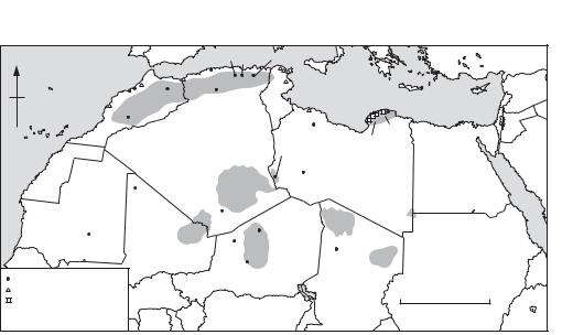
Clark 1980; Williams and Faure 1980). The period between 100,000 and 40,000 was one of the latter phases of settlement expansion, marked by Aterian industries broadly comparable with the European MOUSTERIAN; the most important stratigraphy is still that of HAUA FTEAH, a huge cave in Cyrenaica, northeast Libya (McBurney 1967).
Conditions of severe aridity returned between 40,000 and the end of the Pleistocene c.12000 years ago, forcing a major retreat from the Saharan zone. The Haua Fteah now was occupied by huntergatherers using Dabban backed-blade industries which developed in ways not dissimilar to the European Upper Palaeolithic sequence, ending with an industry characterized by numerous small backed bladelets termed the Eastern Oranian. Similar industries, termed IBEROMAURUSIAN, have been found across the rest of the North African coastal region from Tunis to Morocco (see TAFORALT). The system of subsistence included hunting animals such as Barbary sheep and cattle and collecting land and water molluscs (Saxon et al. 1974). The early Holocene brought a return to wetter conditions. On the coast, people developed more diversified systems of subsistence (Lubell 1984) and settlement expanded once more into the interior, the EPIPALAEOLITHIC people of this period with microlithic technologies (c. uncal 12,000–7000 BP) probably practising a broadly based system of subsistence involving fishing, fowling and plant gathering as well as hunting – much as in Egypt (Smith 1982). Typical sites are
AFRICA 11
the Two Caves and Torha East Caves in the Tadrart Acacus mountains (Barich 1987), AMEKNI in southern Algeria (Camps 1969) and Tamaya Mellet in Niger (Smith 1980). Pottery was being used by these hunter-fisher-gatherers by uncal 7500–6500 BC.
1.2. The transition to farming. Twenty years ago, archaeologists characterized the change from hunting to farming in North Africa as a simple process of colonization, the movement from east to west of new people from the Nile valley, one stream along the coast around uncal 4500 BC (McBurney 1967) and the other across the Sahara around uncal 3500 BC (Hugot 1968; Camps 1969). Today it seems much more likely that the process mainly involved the adoption of new resources by the indigenous population. Domestic sheep may have spread along the Mediterranean littoral as prestige items of exchange among the hunter-fisher-gatherers (Lewthwaite 1986).
The hunter-fisher-gatherers of the Sahara began to specialize more on collecting plant foods and on hunting steppic animals perhaps as early as the 6th millennium BC (uncal). By the end of the 5th millennium BC (uncal) they were herding domestic cattle (probably for meat, milk and blood) in most of the Saharan uplands, for example in the Tassili- n-ajjer in Algeria (Aumassip 1981; Aumassip and Jacob 1976), Tadrart Acacus in Libya (Barich 1987) and Air in Niger (Roset 1981; 1983, see ADRAR BOUS), and in the TAOUDENNI BASIN in Mali (PetitMaire and Riser 1983). Much of
N |
|
|
|
|
|
|
|
|
Mechta Ain |
|
Capeletti |
|
|
|
|||
|
|
|
|
|
|
|
|
el-Arbi |
Hanech |
|
|
|
|||||
|
|
|
|
|
|
|
Ternifine |
a |
i |
n |
TUNISIA |
Carthage |
|
|
|||
Sidi Abderrahman |
Taforalt |
|
o |
u n t |
|
|
|||||||||||
M |
|
|
|
|
|||||||||||||
Dar es Soltane |
|
|
|
|
s |
|
Columnata |
|
|
|
|
||||||
Mogador |
|
|
t l |
a |
|
|
Lepcis |
Haua Fteah |
|||||||||
|
|
|
|
|
|||||||||||||
|
|
|
|
|
|
|
|
|
|||||||||
|
|
|
|
|
|
|
|
|
|
||||||||
CANARY |
|
|
A |
|
|
|
|
|
|
|
|
|
|
|
|
|
|
ISLANDS |
|
|
|
|
|
|
|
|
|
|
|
|
|
|
|
|
|
|
Jebel Irhoud |
|
|
|
|
|
|
|
|
|
Gebel |
|
|||||
|
|
|
|
|
|
|
|
|
|
|
|
||||||
|
MOROCCO |
|
|
|
|
|
|
|
|
|
|
Tripolitania |
|
|
|||
|
|
|
|
|
|
|
|
|
|
|
Cyrenaica Akhdar |
|
|||||
|
|
|
|
|
ALGERIA |
|
|
|
|
|
|
||||||
|
|
|
|
|
|
|
|
|
|
Tadrart Acacus |
|
|
|||||
|
|
|
|
|
|
|
|
|
|
|
|
|
|
|
|||
|
|
|
|
|
|
|
|
|
|
|
|
|
|
Fezzan |
LIBYA |
|
EGYPT |
|
|
|
|
|
|
|
|
|
|
|
|
- |
|
Zinchecra |
|
|
|
|
|
|
|
|
|
|
|
|
|
|
-n |
|
|
|
|
|
|
|
|
|
|
|
|
|
|
|
Tassili |
|
|
|
|
|
|
||
|
|
|
Taoudenni |
|
|
|
ajjer |
|
|
|
|
|
|
||||
|
|
|
Basin |
|
|
|
|
Hoggar |
|
|
|
|
|
||||
MAURITANIA |
|
|
|
|
|
|
|
|
|
|
|
|
|||||
|
|
|
|
|
Adrar |
Amekni |
|
|
|
Tibesti |
|
Jebel Uweinat |
|||||
|
|
|
|
|
|
|
|
|
|
Adrar Bous |
|
||||||
|
|
|
|
MALI |
des |
|
|
|
|
|
|
||||||
Dhar Tichitt |
|
|
|
Iforas |
Tamaya |
Air |
|
|
Yayo |
|
|
||||||
|
|
|
|
|
|
|
|
|
|
NIGER |
|
|
Ennedi |
|
|||
|
|
|
|
|
|
|
|
|
Mellet |
|
|
|
|
SUDAN |
|||
|
|
|
|
|
|
|
|
|
Agadez |
|
|
|
CHAD |
||||
archaeological site or region |
|
|
|
|
|
|
|
|
|
|
|||||||
|
|
|
|
|
|
|
|
|
|
|
|
CHAD |
|
|
|||
Phoenician colony |
|
|
|
|
|
|
|
|
|
|
|
|
|
|
|
0 |
1000 km |
Greek colony |
|
|
|
|
|
|
|
|
|
|
|
|
|
|
|
||
|
|
|
|
|
|
|
|
|
|
|
|
|
|
|
|
|
|
(only colonies mentioned in |
|
|
|
|
|
|
|
|
|
|
|
|
|
|
|
|
|
the text are named) |
|
|
|
|
|
|
|
|
|
|
|
|
|
|
|
|
|
Map 1 Africa, 1: North |
Some major sites in the region. |
|
|
|
|
|
|||||||||||
12 AFRICA
ART may reflect the changing ideologies of Saharan societies during the transition from hunting to herding between about uncal 6000 and 3000 BC, though the precise correlations with climatic change are still unclear. It is generally agreed that significant aridity was established by about 2500 BC, but it is still debatable whether the early phase of cattle pastoralism correlated with the beginnings of the trend to aridity or, as Muzzolini, for example, argues, with an oscillation towards a moister climate, which he calls a ‘Neolithic wet phase, between 4500 and 2500 BC (Muzzolini 1993). While the climatic context of early pastoralism therefore remains unclear, the increasing importance of sheep and goats over cattle in the 4th and 3rd millennia BC (Aumassip and Delibrias 1983; Barich 1987) suggests increasingly arid conditions.
The nature of settlement over the next 2000 years is unclear. The climate and environment of the modern Sahara had developed by c.2500 BC (Shaw 1976). Neolithic-style pottery continued in use in Cyrenaica long after it went out of use in the northern Mediterranean (Bacchielli 1979; Baldassarre 1987; Tiné 1987). Egyptian sources of this period indicate occasional contacts with the pastoralist ‘Tjehenu’ and ‘Tjemehu’ peoples in Libya (Leahy 1990), and there is archaeological evidence for predominantly pastoral societies further west in Algeria (Roubet 1979), the ancestors of the modern Berbers (Camps 1982). Cereal cultivation may not have begun in the Saharan oases until the later 2nd and early 1st millennia BC on the evidence of such sites as in Mauritania (Munson 1976) and ZINCHECRA in the Libyan Fezzan (Van der Veen 1992), in both cases associated with sedentary competitive societies in fortified settlements; in the Fezzan, it may also have coincided with the construction of the first foggaras for channelling floodwaters to the fields.
1.3. From Phoenician and Greek colonization to Romanization. In the 8th and 7th centuries BC, the Phoenicians from the eastern Mediterranean established colonies on the North African coast from LEPCIS in Libya to MOGADOR in Morocco (Law 1978) and the Greeks settled in Cyrenaica soon afterwards (Boardman 1980). The colonies traded for raw materials with their hinterlands promoting the development of Berber client-kingdoms there, and several such as Carthage also became the endpoints for tans-Saharan trade: pottery, glass and metalwork went south in return for commodities such as salt, skins, ivory and slaves. The best evidence for indigenous settlement in the desert at this time is from Zinchecra in the Libyan Fezzan, the
homeland of the Garamantes described by Herodotus (Daniels 1970; 1989).
By the 3rd century BC Carthaginian supremacy over the western Mediterranean was threatened by the expanding power of Rome, the bitter Punic Wars finally ending with the destruction of Carthage in 146 BC. Under Julius Caesar and Augustus direct Roman control was concentrated in Tunisia behind Carthage, but in the 1st and 2nd centuries Roman Africa extended from the former client-states of Mauritania and Numidia (roughly the western and eastern Maghreb respectively) eastwards across northern Libya to Cyrenaica (Fentress 1979, Raven 1993). The incorporation of the North African littoral and Maghreb into the Roman world also had a profound impact on the peoples living in the frontier zone to the south.
C.B.M. McBurney: The Stone Age of northern Africa
(Harmondsworth, 1960); Y. Coppens: ‘An early hominid from Chad’, CA 7 (1965), 584–5; C.B.M. McBurney: The Haua Fteah (Cyrenaica) and the Stone Age of the south-east Mediterranean (Cambridge, 1967); H. Hugot: ‘The origins of agriculture: the Sahara’, CA 9 (1968), 483–9; G. Camps:
Amekni: Néolithique ancien du Hoggar (Paris, 1969); M.C. Chamla: Les hommes epipaléolithiques de Columnata, Algérie occidentale (Paris, 1970); C. Daniels: The Garamantes of southern Libya (Cambridge, 1970); E.T. Saxon et al.: ‘Results of recent investigations at Tamar hat’, Libyca 22 (1974), 49–91; M. Van Campo: ‘Pollen analyses in the Sahara’, Problems in prehistory – North Africa and the Levant, ed. F. Wendorf and S. Marks (Dallas, 1975), 45–64; G. Aumassip and J.P. Jacob: ‘Les grottes de Ti-n- Hanakaten au Tassili des Ajjers’, Archeologia 94 (1976), 28–37; P.J. Munson: ‘Archaeological data on the origins of cultivation in the southwestern Sahara and their implications for West Africa’, Origins of plant domestication, ed. J.R. Harlan et al. (The Hague, 1976), 187–210; B.D. Shaw: ‘Climate, environment and prehistory in the Sahara’, World Archaeology 8 (1976), 133–48; M.C. Chamla: ‘Le peuplement de l’Afrique du Nord de l’epipaléolithique à l’époque actuelle’, L’Anthropologie 82 (1978), 385–430; R.C.C. Law: ‘North Africa in the age of Phoenician and Greek colonization’, Cambridge History of Africa II, ed. J.D. Fage (Cambridge, 1978), 87–147; L. Bacchielli: ‘Contatti fra ‘Libya’ e mondo egeo nell’età del bronzo: una conferma’, Rendiconti Accademia Lincei 34 (1979), 163–8; E. Fentress: Numidia and the Roman army
(Oxford, 1979); C. Roubet: Economic pastorale préagricolé en Algérie orientale: le Néolithique de tradition Capsienne
(Paris, 1979); J. Boardman: The Greek overseas (London 1980); J.D. Clark: ‘Human populations and cultural adaptations in the Sahara and Nile during prehistoric times’, The Sahara and the Nile, ed. M.A.J. Williams and H. Faure (Rotterdam, 1980), 527–82; A.B. Smith: ‘The neolithic tradition in the Sahara’, The Sahara and the Nile, ed. M.A.J. Williams and H. Faure (Rotterdam, 1980), 451–65; M.A.J. Williams and H. Faure, eds: The Sahara and the Nile (Rotterdam, 1980); G. Aumassip: ‘Ti-n- Hanakaten (Tassili-n-Ajjers, Algérie): Bilan de 6
campagnes de fouilles’, Libyca 28–9 (1981), 115–27; J.P. Roset: ‘Les plus vieilles céramiques du Sahara’, Archéologie (1981), 43–50; G. Camps: ‘The beginnings of pastoralism and cultivation in northwest Africa and the Sahara: origins of the Berbers’, Cambridge History of Africa I (Cambridge, 1982), 548–623; P.E.L. Smith: ‘The late palaeolithic and epipalaeolithic of northern Africa’, History of West Africa I, ed. J.F.A. Ajadi and M. Crowder (Cambridge, 1982), 342–409; G. Aumassip and G. Delibrias: ‘Age des dépôts néolithiques du gisement de Ti-n-Hanakaten (Tassili-n-Ajjes, Algérie)’, Libyca 30–31 (1983), 207–11; N. Petit-Maire and J. Riser: Sahara ou Sahel? Quaternaire récent du Bassin de Taoudenni (Mali)
(Marseilles, 1983); J.P. Roset: ‘Nouvelles données sur le problème de la Néolithisation du Sahara méridional: Air et Tenéré, au Niger’, Cahiers ORSTOM 13/2 (1983), 199–42; D. Lubell: ‘The Capsian palaeoeconomy in the Maghreb’, Origins and early development of food-producing cultures in north-eastern Africa, ed. L. Krzyzaniak and M. Kobusiewica (Poznan, 1984), 453–5; J. Lewthwaite: ‘The transition to food production: a Mediterranean perspective’, Hunters in transition, ed. M. Zvelebil (Cambridge, 1986), 53–66; I. Baldassarre: ‘Tracce dell’abitato prebattiaco ad ovest dell’Agora di Cirene’, QAL 12 (1987), 17–24; B. Barich: Archaeology and environment in the Libyan Sahara (Oxford, 1987); S. Tiné: ‘Ceramica prebattiaca nell’area cirenea’, QAL 12 (1987), 15–16; C. Daniels: ‘Excavation and fieldwork among the Garamantes’, LS 20 (1989), 45–61; A. Leahy, ed.: Libya and Egypt c.1300–750 BC (London, 1990); M. Van der Veen: ‘Garamantian agriculture: the plant remains from Zincechra, Fezzan’, LS 23 (1992), 7–39; A. Muzzolini: ‘The emergence of a food-producing economy in the Sahara’, The Archaeology of Africa: food, metals and towns, ed. T. Shaw, P. Sinclair, B. Andah and A. Okpoko (London, 1993), 227–39; S. Raven: Rome in Africa, 3rd edn (London, 1993); M. Brunet et al.: ‘The first Australopithecine 2,500 km west of the Rift Valley, Chad’, Nature 378 (1995), 273–5.
GB
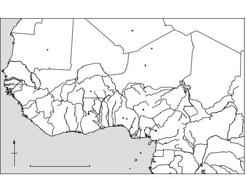
2 West Africa
Conventionally, West Africa is taken to be bounded on the north by the Tropic of Cancer and on the south and west by the Atlantic ocean; in modern political terms, its eastern boundary is often taken to coincide with the frontiers of Nigeria and Niger, but geographically and historically there are valid reasons to include Chad and Cameroun also. As Thurstan Shaw says, West Africa is a well-defined region which has its own historical ‘personality’; perhaps because, as Mabogunje and Richards put it, a gradual dessication of the Sahara in recent millennia has given it an ‘island-like character’. Contrasting vegetational zones have been recognised by both Francophone and Anglophone writers (A. Chevalier and R.W.J. Keay) trending broadly from west to east and reflecting decreasing
AFRICA 13
annual rainfall from south to north (currently <1600 mm on the coast and >5 mm in some parts of the Sahara). Mangrove swamp and rain forest are succeeded by belts of Guinea, Sudan, and Sahel savanna, and then by the desert itself. Between the forest and Guinea savanna zones there is a belt of ‘derived savanna’, thought to have been brought about by human action (farming and fire). Savanna should be understood not as a tree-less plain but as a mixture of grass and woodland, the latter moister in the south and drier in the north. Sahel, as pointed out by Connah, is the Arabic word for ‘shore’; the sea it faced was the desert, and the towns which eventually developed in this area were ‘ports’. At one area on the south coast, the ‘Dahomey Gap’, the savanna comes down to the sea, and there are also patches of montane vegetation on the Fouta Djallon and Cameroun highlands. In West Africa generally high elevations are rare, but in the central Sahara the Adrar des Iforas, Hoggar, Tassili-n-Ajjer, Air, and Tibesti mountains all rise <1000 metres. Except for the lake Chad and river Niger drainage systems, most rivers flow more or less direct to the sea.
In terms of present-day political geography, West Africa is split into a number of nation states, the boundaries of which were established in colonial times, when French and English also came into use as official languages. These boundaries are certainly important, in this context because different Francophone and Anglophone traditions have had a marked effect on the development of archaeological research in the countries concerned, but there is no correspondence between them and other divisions which have been of historic significance in West Africa. Thus the number of major ethnic groups (some the centre of historic kingdoms such as the Yoruba, the Hausa, and the Ashanti) far exceeds the number of nation states and does not coincide with them, and the same is true of the major African languages. These can however be grouped into three large language families which are represented in this region: Nilo-Saharan, AfroAsiatic, and Niger-Congo. Some tentative attempts have been made to link these language families to events in prehistory. Nilo-Saharan is the most internally diversified and the most fragmented geographically, hence it has been suggested that it is the most ancient; its speakers according to Sutton may
have created an AQUATIC CIVILIZATION at
the beginning of the Holocene. Niger-Congo is the most widespread, including many languages spoken in West Africa, as well as Bantu, and it is a popular hypothesis that the Bantu peoples spread to most of Central and Southern Africa from an original base
14 AFRICA
in the Cameroon highlands. Since no words associated with cultivation can be securely reconstructed to Proto-Niger-Congo, it is inferred that the primary divisions in the phylum may have occurred before the development of agriculture, and the same is taken to be true of Afro-Asiatic. If this reconstruction is correct, then presumably the origins of these language families also go back to the early Holocene.
2.1. Climatic change. The climate of West Africa is in large part determined by the annual movement of the InterTropical Convergence Zone (ITCZ), from about 19° N in summer to 6° N in winter, reflecting the relative strength of the humid marine southwesterly (monsoon) and dry continental northeasterly (harmattan) trade winds. Marine and lacustrine cores have provided evidence (oxygenisotope and pollen records, radiocarbon dates, and other environmental indicators such as diatoms and quartz grains) on the basis of which a succession of late Quaternary arid and humid phases has been recognised, corresponding to more southerly and more northerly positions of the ITCZ and broadly speaking to the glacials and interglacials of northern temperate latitudes.
The transition from the late Glacial to the early Holocene has been studied in particular detail. The late glacial maximum at 18,000 BP was marked by
extreme aridity; general circulation models suggest that the climatic amelioration which followed was triggered by an increase in northern summer radiation peaking at 11,000 BP leading to stronger monsoon activity with a climax at 9000 BP. At that time precipitation is estimated to have been at least 25% greater than today, and the northern movement of the isohyets meant that areas (such as the TAOUDENNI BASIN and the Oyo depression in northwest Sudan) which now have >5 mm annual rainfall then had up to 400 mm. Deglaciation proceeded in two main ‘steps’, interrupted by a dry phase between 11,000 and 10,000 BP corresponding to the Younger Dryas event in northern temperate latitudes. Initial warming started at about 13,500 BP, when deposition of terrigenous material commenced in the Niger delta, and a montane-like wooded grassland suggesting mean temperatures 2–3°C lower than today was established around lake Bosumptwi in southern Ghana. The Holocene climatic optimum lasted from about 10,000 to 4000 BP, when many lakes including ‘Megachad’ were at a high stand and the West African vegetational zones were shifted 400–500 km to the north. Mean temperatures may have been up to 2.5°C higher than today. Following a regression, there are some signs of moderate climatic amelioration at about 3000 BP, for example at Kobadi in the ‘dead delta’
WESTERN |
|
Taoudenni |
|
ALGERIA |
|
|
LIBYA |
SAHARA |
|
Basin |
|
Amekni |
|
||
|
|
|
|
|
|||
|
|
|
|
|
|
||
MAURITANIA |
|
|
|
|
|
|
|
Dhar Tichitt |
|
|
|
Adrar Bous |
|
|
|
MALI |
|
|
|
|
|
||
Sintou-Bara |
|
|
|
|
NIGER |
|
|
|
|
|
Agadez |
|
|
|
|
Cap Manuel |
|
|
|
|
|
|
CHAD |
SENEGAL |
Jenne-jeno |
|
|
|
|
|
|
|
|
|
|
|
|
||
|
|
BURKINA |
|
|
|
|
|
GUINEA- |
|
FASO |
|
|
|
|
|
BISSAU |
Upper Volta |
|
|
|
Daima |
|
|
GUINEA |
|
|
|
|
|
|
SSUDANN |
|
|
|
|
BENIN |
NIGERIA |
|
|
|
|
|
|
|
|
||
SIERRA |
|
Kintampo |
TOGO |
Nok |
|
|
|
IVORY |
|
|
CAMEROON |
|
|||
LEONE |
Begho |
Iwo Eleru |
Cross |
|
|||
|
COAST |
GHANA |
|
Ife Igbo Ukwu |
River |
|
|
LIBERIA |
|
|
|
CENTRAL AFRICAN |
|||
|
|
|
|
Monoliths |
|
||
|
|
Asokrochona Benin |
Shum Laka |
REPUBLIC |
|||
|
|
|
|||||
N |
|
|
|
|
|
|
|
|
|
|
|
Ugwuele Uturu |
|
|
|
|
|
|
|
|
Obobogo |
|
|
|
|
|
|
EQUATORIAL |
|
|
|
|
|
|
|
GUINEA |
|
ZAIRE |
|
0 |
|
1000 km |
|
|
|
CONGO |
|
|
|
|
|
|
|||
|
|
|
|
|
GABON |
|
|
Map 2 Africa, 2: West Major prehistoric sites in the region.