

A Dictionary of Archaeology
.pdfof Bonn, 1992; H. Utagawa: ‘The “sending back” rite in Ainu culture’, JJRS 19/2–3 (1992), 255–70.
SK
Air see AFRICA 1; SAHARAN ROCK ART
airborne remote sensing Term used for the aerial recording of data in wavelengths outside the visible range. The necessary equipment may be borne by satellites or by aircraft flying in systematic patterns – as in normal vertical photography.
The only form of extra-visible photography used in conventional archaeological reconnaissance is the use of infra-red photographic film, either black and white or false colour, where in some conditions the data recorded in the near infra-red waveband can enhance the information visible to the naked eye. Infra-red photography is used by some aerial archaeologists as a valuable ancillary to other films. The other forms of electromagnetic energy (of which the visible range forms a small part) recorded either through photography or digital imaging include the ultra-violet, the near, middle and thermal infra-red, and the microwave. Imaging from aircraft can provide direct evidence of archaeological features, as well as a wide range of information on geology, vegetation, climate, land-use, hydrology etc. Information from airborne remote-sensing is often enhanced by recording different wavelengths simultaneously – this is known as multispectral imaging and may be combined with conventional photography. Although the resolution of satellite material available for civilian use is not yet good enough for the recognition of most archaeological features, it is already valuable for predictive purposes.
P.J. Curran: Principles of remote sensing (New York, 1985); S.A. Drury: A guide to remote sensing: interpreting images of the earth (Oxford, 1990); J. Allsop and D. Greenbaum: ‘Airborne remote sensing of alluvial deposits in the reconnaissance of potential archaeological sites’, Proceedings of the Third National Archaeological Sciences Conference 1991, ed. J. Szymnaski.
FG
Ajanta see CAVE TEMPLE
Ajdabiya Site on the coast of Libya, which is one of several Fatimid settlements of the 10th century AD that were established during the revival of the coastal region for the first time since the Islamic conquest. A mosque and a fortress (qasr) were among the buildings constructed at Ajdabiya as a result of the ambition of the Fatimid Caliphs in Tunisia (Ifriqiya)
AKKAD, AKKADIAN 35
to expand eastwards. This ambition culminated in their seizure of Egypt and the foundation of Cairo in AD 969. Sites such as Ajdabiya mark the first important Islamic foundations in Libya after the Islamic conquest. Beyond their intrinsic interest, the Fatimid sites in Libya provide a background against which to set the subsequent ‘efflorescence regime’ after it had been subsumed by the cultural vitality of Egypt. The ceramics from Ajdabiya and other Libyan sites form a corpus that generally precedes the eclipse of north African after 1051 when the Fatimid Caliph al-Mustansir sent the Bani Hilal and the Bani Sulaym nomads to attack his former supporters in North Africa.
A. Abdussaid: ‘Early Islamic monuments at Ajdabiyah’, Libya Antiqua I (1964), 115–19; D. Whitehouse: ‘The excavations at Ajdabiyah: an interim report’, LS 3–4 (1972–3) [interim reports]; G.R.D. King: ‘Islamic archaeology in Libya, 1969–1989’, LS 20 (1989), 193–207.
GK
Akhetaten see AMARNA, (TELL) EL-
Akhmim (anc. Ipu, Khent-Mim) Egyptian site on the east bank of the Nile opposite the modern city of Sohag. Akhmim has been occupied continuously from the Early Dynastic period to the present day. The pharaonic settlement at Akhmim was the centre of the 9th nome (province) of Upper Egypt, but because of extensive quarrying of the buildings in the 14th century AD, little has survived either of the pharaonic town or of the temples of Min, the god of fertility. The Old and Middle Kingdom rock-tombs and a well-preserved 18th-dynasty rock-cut chapel were examined by Percy Newberry in 1910, and the former were re-examined by Naguib Kanawati during the 1980s. Colossal statues of Ramesses II and his wife Meritamun were excavated in the 1990s by Egyptian archaeologists.
P.E. Newberry: ‘The inscribed tombs of Ekhmim’, LAAA 4 (1912), 101–20; K.P. Kuhlmann: ‘Der Felstempel des Eje bei Akhmim’, MDAIK 35 (1979), 165–88; N. Kanawati: Rock tombs of El-Hawawish: the cemetery of Akhmim, 6 vols (Sydney, 1980–); K.P. Kuhlmann:
Materialen zur Archäologie und Geschichte des Raumes von Achmim (Mainz, 1983); E.J. Brovarski: Akhmim in the Old Kingdom and First Intermediate Period, Milanges Gamal Eddin Mokhtar I (Cairo, 1985).
IS
Akkad, Akkadian The term Akkadian was used from the early 3rd millennium BC to refer to the Semitic-speaking people who gradually supplanted the non-Semitic SUMERIANS in central Mesopotamia. Sargon the Great (sharru-kin: ‘the true king’) established the Akkadian dynasty
36 AKKAD, AKKADIAN
(c.2317–2150 BC), the first Semitic-speaking empire in Mesopotamia, which eventually disintegrated as a result of the incursions of nomads such as the AMORITES and GUTIANS. The location of Akkad (or Agade), the Akkadian capital city, remains uncertain, although various sites have been suggested; it is thought most likely to be in the region of KISH OR BABYLON. From the time of Sargon onwards the CUNEIFORM script was used to record the Akkadian language, and the Sumerian tongue was preserved only in certain names and archaisms.
H. Weiss: ‘Kish, Akkad and Agade’, JAOS 95 (1975), 434–53; J. Oates: Babylon, 2nd edn (London, 1986), 22–59; G. Roux: Ancient Iraq, 3rd edn (Harmondsworth, 1992), 146–60.
IS
Ak-Kaya (Zaskal’naya) Group of Palaeolithic shelters in the Red Ravine near the village of Vishennoye in the Crimea, 50 km east of Simferopol. The group, which includes 13 sites, was discovered in 1964 by V.F. Petrun and excavated in the 1970s and 1980s by Y.G. Kolosov. The site of Zaskal’naya 5 comprises eight MOUSTERIAN levels with abundant faunal remains, numerous hearths and a rich flint inventory similar to that of the upper level of KIIK-KOBA CAVE (also in the Crimea). A fragment of a human skull (occipital bone), found in a trench pit further down the slope beneath the main concentration of finds, may belong to a female Neanderthal. Zaskal’naya 6, 70 m uphill from Zaskal’naya 5, consists of five Mousterian levels. Level 3 contained the remains of burials of five children, aged 8–12 years old, classed as Homo sapiens neanderthalensis. The skeletal evidence is morphologically similar to that from Kiik-Koba, in Uzbekistan and some
Palestinian NEANDERTHALS (see AMUD, MOUNT
CARMEL). Sedimentation and pollen evidence suggests that the Mousterian sequence of Ak-Kaya belongs to the early stages of the Würm glacial.
Yu.G. Kolosov: ‘Akkaiskie must’erskie stoyanki i nekotorye itogi ih izucˇenija’ [The Ak-Kaya Mousterian sites and some results of their studies], Issledovanie paleolita v Krymu [Palaeolithic studies in the Crimea], ed. Yu.G. Kolosov (Kiev 1979), 33–55.
PD
Akrotiri see THERA
Aksum see AXUM
al- The prefix alis disregarded in the alphabetical sequence of this dictionary. For example, al-KUFA.
Alaca Hüyük see HITTITES
Alalakh see ATCHANA, TELL
Albany industry (Oakhurst industry) Term applied to a group of southern African Stone Age assemblages found south of the Zambezi River, but known mostly from sites south of the Limpopo River. The industry is characterized by the presence of large scrapers (L< 20 mm), but bladelets, bladelet cores and backed microliths tend to be either absent or extremely rare. Other formal tools in stone are rare. In coastal sites bone is used for points (probable fish gorges), spatulas, and beads. Rare bored stones (digging-stick weights) are recorded, and engraved stones are known from two sites. It is sometimes referred to as the Oakhurst industry after the site of OAKHURST (Sampson 1974); assemblages generally fall between uncal 12,000 and 8000 BP, and intervene stratigraphically between the Late Pleistocene microlithic Robberg Industry and the Holocene microlithic WILTON INDUSTRY. Mitchell (1988: 247) has argued that the shift from the Robberg to the Albany reflects the adoption of the bow and arrow. See also AFRICA 4.1.
R.G. Klein: ‘Environment and subsistence of prehistoric man in the southern Cape Province, South Africa’, WA 5 (1974), 249–84; C.G. Sampson: The Stone Age archaeology of southern Africa. (New York, 1974); J. Deacon: The Later Stone Age settlement of southernmost Africa (Oxford, 1984); P. Mitchell: The early microlithic industries of southern Africa (Oxford, 1988).
RI
Aleutian tradition Distinctive tradition of the Aleutian Islands and the westernmost Alaska Peninsula, which dates from 2500 BC through to historic times. The assemblages are characterized by flaked stone implements, including knives and stemmed points.
D.E. Dumond: The Eskimos and Aleuts (London, 1987).
RP
Alexandria Greco-Roman city on the Mediterranean coast of Egypt which was founded by Alexander the Great on the site of an earlier Egyptian settlement called Raqote. The latter has survived only in the form of the pre-Ptolemaic seawalls to the north and west of the island of Pharos. Alexandria was a cultural melting pot, particularly during the Ptolemaic and Roman periods (c.332 BC–AD 395), when the population gradually expanded, reaching about half a million by the middle of the 1st century BC. The major GrecoRoman monuments were the Library, the Museum,
the Serapeum (a temple of the god Sarapis, which may have incorporated part of the Alexandrian library), the Caesarium, a Roman stadium and Kom el-Shugafa (funerary catacomb dating to the first two centuries AD). On a peninsula about 1.5 km off the coast of Alexandria was the early Ptolemaic multi-storey pharos, which was the first known lighthouse in the world. It appears to have collapsed in the 12th century AD, but in 1995 French marine archaeologists, working on the sea-bed near the Qait Bey Islamic-period fortress, lifted a number of fragments of stone believed to derive from it (Empereur 1996).
P.M. Fraser: Ptolemaic Alexandria, 3 vols (Oxford, 1972); A.K. Bowman: Egypt after the pharaohs (London, 1986), 204–33; J.-Y. Empereur: ‘Alexandria: the underwater site near Qaitbay fort’, EA 8 (1996), 7–10.
IS
alignment In its strictest sense, the term ‘alignment’ refers to a class of simple prehistoric monuments that consist either of two or more stones marking a straight line, or a single marker set up to form a line in conjunction with a natural feature such as a mountain top. Alignments are often assumed to mark some astronomically or mythically significant point on the horizon.
Some of the greatest concentrations of stone alignments are found in Britain (such as the numerous small alignments found on Dartmoor) and Brittany (the most famous alignments in the world are found at CARNAC), where the majority seem to date from the 3rd or early second millennium BC. However, simple alignments are present in regions all around the world, notably India (North Karnataka), Indonesia and Malaysia. In the remoter regions of the world, alignments continue to be discovered; for example, the alignments recently surveyed at the Old Kingdom quarry site of Hatnub in the Eastern desert of Egypt, where simple rows of small monoliths seem to have been erected by the visiting quarriers as temporary shrines.
Apart from defining a specific class of monuments, the term alignment is used widely in the sub-discipline of archaeoastronomy to indicate any astronomically significant line incorporated in more complex monuments. These alignments often take the form of a selection of the very large number of possible ‘lines’ that can be drawn between the stones of complex megalithic structures such as STONE CIRCLES; the difficulty of proving that such alignments were intentional on the part of the builder is discussed in Heggie (1981). The term alignment is also used to describe the creation of astronomical
ALIS¸AR HÜYÜK 37
alignments in the architectural elements of sophisticated monumental buildings; two famous examples are the passage alignments at the main temple of ABU SIMBEL, Egypt, and the passage grave of KNOWTH, Ireland.
S. Heggie: Megalithic science (London, 1981); C.L.N. Ruggles: Megalithic astronomy, BAR BS 123 (Oxford 1984); A Ghosh, ed.: an encyclopaedia of Indian archaeology
(New Delhi, 1989).
RJA
Aligrama see GANDHARA GRAVE CULTURE
Ali Kosh, Tepe Mound in the Deh Luran valley of southwestern Iran (LURISTAN); it consists of a sequence of Epipalaeolithic occupation remains similar to those at the nearby site of TEPE SABZ, the earliest of which (the ‘Bus Mordeh phase’) date to c.8000–7000 BC. During this first phase the settlement was already made up of small mud-brick houses and the subsistence base included a combination of goat-herding and hunting. The principal strata at the site comprise the ‘Ali Kosh phase’ (c.7000–6000 BC), during which cultivated emmer and barley began to be used, and the repertoire of artefacts expanded to include a new range of butchery tools. The excavations of Hole and Flannery at Ali Kosh and other sites of similar date in the Deh Luran region have produced a great deal of information on the origins of food production in the Near East (Hole et al. 1965; 1969).
F. Hole and K.V. Flannery: ‘Excavations at Alikosh, Iran, 1961’, Iranica antiqua 2 (1962), 97–148; F. Hole, K.V. Flannery and J.A. Neely: ‘Early agriculture and animal husbandry in Deh Luran, Iran’, CA 6 (1965), 105–6; F. Hole et al.: Prehistory and human ecology in the Deh Luran plain: an early village sequence from Khuzistan, Iran (Ann Arbor, 1969).
IS
Alis¸ar Hüyük (anc. Ankuwa?) Hittite city site in Cappadocia, about 200 km from Ankara, the ceramic sequence from which forms part of the basis for the Bronze Age chronology of Anatolia from the mid-3rd millennium onwards. The site was excavated by Hans von der Osten and Erich Schmidt in 1927–32. In level II (c.2300–1900 BC) they found distinctive ‘Cappadocian’ painted pottery as well as cuneiform tablets from a karum (settlement of Old Assyrian merchants) like that at KANESH. Later levels at Alis¸ar (III–VII) corresponded to the Hittite empire and successive phases of Phrygian, Achaemenid, Seleucid, Parthian, Roman and Seljuk domination.
H. von der Osten: Alishar Hüyük, 3 vols (Chicago, 1937).
IS
38 ALLÉES COUVERTES
allées couvertes French archaeological term related to the English archaeological term ‘gallery grave’, which describes a set of Neolithic and Chalcolithic monumental tombs that lack a welldefined entrance passage (i.e. are not PASSAGE GRAVES) and which have elongated (up to 20 m long) rectangular chambers (sometimes with vestibules), and which are often constructed of parallel rows of orthostats. The classic regions in the study of allées couvertes are Britanny and, especially, the Paris Basin, where they are associated with the late Neolithic SOM CULTURE and date largely to the later 3rd millennium BC and after. In Brittany, the chambers are often above ground, and covered with an oval mound. In the Paris Basin, most chambers are cut into the earth or rock (up to 2 m deep), and were often roofed with timber at groundlevel; there may be no mound at all. The chambers usually possess ante-chambers, and the main chamber is commonly entered via a roundish opening cut through a transverse slab. Many allées couvertes are decorated with a repeated set of schematic motifs, notably reliefs of two breasts, sometimes with a necklace, and hafted axes. The SOM culture also disposed of its dead in hypogeés, typically rectangular, sometimes with an antechamber, hollowed out of solid chalk, and in pits. All of these tomb types tend to be associated with the practice of collective burial (of up to 350 individuals).
J. Howell: ‘The later Neolithic of the Paris Basin’, Ancient France 6000–2000 BC, ed. C. Scarre (Edinburgh, 1983), 64–8; C. Masset and P. Soulier: Alleés couvertes et autres monuments funéraires du néolithique dans la France (Paris, 1995).
RJA
alpha recoil dating Scientific dating technique used on the minerals in ceramics or lava flows. The process is similar to FISSION TRACK DATING, but using the much more frequent alpha decay of the naturally occurring 238U, 235U and 232Th chains. When a nucleus emits an alpha particle, it recoils and creates a damage track. If the various decay chains are present in known concentrations and each is in equilibrium (or the disequilibrium is quantified), then the number of tracks per unit of time can be calculated. Heating anneals any previous damage. In principle, the number of tracks present since the last heating of the material can be counted after suitable etching of a prepared surface, thus allowing the age of minerals to be inferred.
Although alpha recoil tracks are much more numerous than fission tracks, they are also much shorter because the recoil is less energetic than
spontaneous fission fragment emission. Alpha recoil tracks are thus more difficult to identify reliably and the technique has found little application in archaeology.
W.H. Huang and T.E.R.M. Walker: ‘Fossil alpha particle recoil tracks’, Science 155 (1967), 1103–4; E.G. Garrison et al.: ‘Alpha-recoil tracks in archaeological ceramic dating’, Archaeometry 20 (1978), 39–46.
SB
Altamira Principal example of Upper Palaeolithic (Magdelanian/Solutrean) cave art in Cantabrian Spain, near the town of Santillana del Mar, decorated from perhaps 16,000 BP onwards. Of the animals depicted, bison and red deer are the most numerous with about 50 representations of each. (The faunal remains in the Solutrean and Magdalenian stratigraphic levels associated with the art are dominated by red deer, with bison and horse second and third). The Great Hall or Hall of Bison, a chamber c.10 by 20 m, is impressively decorated with large engraved and brightly coloured polychrome images of 16–19 bison up to 2 m long, a horse and a large red deer (hind). The bison, which may have been painted as a composition by a single artist, may represent a herd in the rutting season or being driven together by hunters; the care with which the bison are depicted may reflect the prestige of the bison as hunting prey. In a terminal chamber, Altamira presents a series of enigmatic masks and signs. There are also stencilled hands and painted hands. Together with EL CASTILLO, Altamira has produced the finest series of mobiliary art plaques in Cantabria – especially scapulae engraved with red deer.
H. Breuil and H. Obermaier: The cave of Altamira at Santillana del Mar, Spain (Madrid, 1935); M.A. García Guinea: Altamira (Madrid, 1979); L.G. Freeman et al.:
Altamira revisited (Chicago, 1987).
RJA
Altyn-depe (Altintepe) Large settlement of Eneolithic/Bronze Age in Southern Turkmenistan, located in the interfluve of the Meana and Chaacha rivers. The first settlement dates to the NAMAZGA I period in the 5th millennium BC; by the end of the 4th millennium the site was a large centre, with ceramics dominated by the ‘GEOKSYUR style’ and rich burials that suggest social stratification. In the mid-3rd millennium BC, the introduction of the potter’s wheel and other social and cultural changes mark the gradual transformation of the site into a proto-urban centre – the most significant in Central Asia – with a large cult building and a number of smaller sanctuaries and temples. The highest
AMARA 39
degree of urbanization was attained during the Middle Bronze Age (end of the 3rd and early 2nd millennia BC). Social differentiation and craft specialization were marked, the site layout revealing isolated elite and craftsmen quarters as well as a cult centre in the form of a ZIGGURAT-type structure on a stepped platform. See also ASIA 1.1/1.2 for a discussion of urbanization at Altyn-depe within a regional context.
V.M. Masson: Pervye civilizacii (Leningrad, 1989);
––––: Altyn-depe: Raskopki goroda bronzovogo veka v Juzhnom Turkmenistane (Leningrad, 1991).
PD
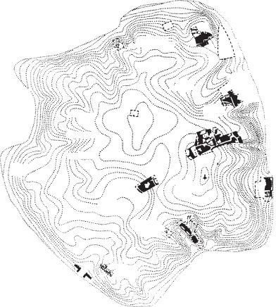
Amara Nubian site 180 km south of Wadi Halfa, consisting of two separate archaeological zones to the east and west of the Nile: Amara West and East.
Craftsman’s
quarter
In the Ramessid period (c.1307–1070 BC) Amara West probably replaced SOLEB as the seat of the Deputy of Kush (Upper Nubia), and the town may also have served as a staging post for gold-mining expeditions and a centre for trade with the Selima Oasis. There are extensive urban remains as well as cemeteries of the New Kingdom and the Ballana period (c.AD 400–543). The pharaonic walled town
–described by its excavator H.W. Fairman as one of the best preserved settlements in the Nile valley
–covered an area of about 60,000 square metres and was occupied between about 1400 and 1070 BC. It incorporated a stone-built temple of Ramesses II, a set of vaulted store-rooms and an extensive area of extra-mural house remains. Amara East is the site of a town and temple of the MEROITIC period (c.300 BC–AD 350).
Small square
|
Mound |
|
Concentration |
of the |
wall |
of domestic
architecture
Milling
tools
High mound
Central
square
Mound of
the Funeral
Chamber
Copper
mound
0 |
100 m |
||
|
|
|
|
Figure 3 Altyn-depe Plan of the mound at Altyn-depe, Southern Turkmenistan, showing the main features of the Eneolithic–Bronze Age settlement. Source: V.M. Masson: Altyn-depe: Raskopki goroda bronzovogo veka v Juzhnom Turkmenistane (Leningrad, 1991).
40 AMARA
H.W. Fairman: Preliminary excavation reports in JEA 24, 25, 34 (1938, 1939, 1948); B.J. Kemp: ‘Fortified towns in Nubia’, Man, settlement and urbanism, ed. P.J. Ucko et al. (London, 1972), 651–6; P.A. Spencer: Amara West (London, 1997).
IS
Amarna, (Tell) el- (anc. Akhetaten) Ancient Egyptian city, located about 280 km south of Cairo, founded by the pharaoh Akhenaten (c.1353–1335 BC). It is the best-preserved Egyptian settlement of the New Kingdom, including several temples, palaces and other public buildings, as well as large numbers of mud-brick private houses. The city was abandoned soon after Akhenaten’s death, having been occupied for only about 25–30 years; this unusually brief period of occupation has made the site ideal for spatial and statistical analyses (Kemp 1984–95, Shaw 1992, Kemp and Garfi 1993), providing an important body of socioeconomic data. Although much of the western side of the city has been covered by modern cultivation, enough of the ceremonial centre and surrounding residential quarters has survived to enable the site to serve as an example of town planning and social patterning in 18th-dynasty Egypt. The original population of the city has been estimated at about 20,000, most of whom would have lived in the so-called ‘south suburb’, stretching between the central city and the modern village of Hagg Qandil. There are two groups of nobles’ rock-tombs at the northern and southern ends of the semi-circular bay of cliffs to the east of the city. The remains of the tombs of Akhenaten and his family, located several kilometres to the east of the cliffs, were rediscovered in the late 1880s (Martin 1974–89), but they have suffered greatly from vandalization.
In the centre of the city a cache of cuneiform tablets was discovered in and around a building identified as the House of Correspondence; these texts, all but three of which were written in AKKADIAN, consisted of letters sent between the late 18th-dynasty pharaohs and the rulers of cities and states in Syria-Palestine, Mesopotamia and Anatolia. The ‘Amarna Letters’ have provided a great deal of evidence concerning Egypt’s political influence and foreign policy in the New Kingdom (Moran 1992).
N. de G. Davies: The rock tombs of El Amarna, 6 vols (London, 1903–8); T.E. Peet et al.: The city of Akhenaten, 3 vols (London, 1923–51); G.T. Martin: The royal tomb at el-Amarna, 2 vols (London, 1974–89); B.J. Kemp, ed.: Amarna reports I–VI (London, 1984–95); W. Moran: The Amarna letters (Baltimore, 1992); I. Shaw: ‘Ideal homes in ancient Egypt: the archaeology of social aspiration’, CAJ
2/2 (1992), 147–66; B.J. Kemp and S. Garfi: A survey of the ancient city of el-‘Amarna (London, 1993).
IS
Amarna Letters see AMARNA (TELL) EL-
Amekni Rock outcrop site 40 km west–- northwest of Tamanrasset, southern Algeria, excavated by Gabriel Camps in 1965 and 1968. Ashy deposits up to 1.65 m thick, between boulders on the eastern side of the site, produced an occupation characterized as ‘Neolithic of Sudanese Tradition’, largely on the basis of the pottery, which consisted of simple round-bottomed vessels extensively decorated with comb impressions including dotted wavy line motifs. There were no polished stone axes or bone harpoons. Three human burials (two children and one adult) were described as ‘negroid’, and there was an exclusively wild mammalian fauna dominated by dorcas gazelle, bohor reedbuck, and giant buffalo. The presence of fish (Clarias and Lates) and freshwater bivalves indicates that the climate was significantly more humid than at present, with rivers which flowed all the year round. Besides Celtis sp., the abundant pollen analysed produced 263 examples of Gramineae, of which two (at a depth of 1.4 m) were identified as cultivated bulrush millet (Pennisetum sp.), although this attribution is not now generally accepted. Four radiocarbon dates span the period from 8670 to 5500 BP. The early occurrence of pottery (with which the human burials at the site were associated) encouraged Camps to claim that pottery vessels had been independently invented in the Saharan region by at least 8050 ± 80 BP.
G. Camps: Amekni, Néolithique ancien du Hoggar (Paris, 1969); A. Gautier: ‘Prehistoric men and cattle in North Africa: a dearth of data and a surfeit of models’, Prehistory of arid North Africa, ed. A.E. Close (Dallas, 1987), 163–87.
PA-J
America
Sections: 1 Arctic North America; 2 Western North
America; 3 Southwestern North America; 4 Eastern
North America; 5 Mesoamerica and Central
America; 6 South America
1 Arctic North America
The extreme conditions in the Arctic region of the North American continent have led to some of the most fascinating adaptations of human life anywhere on earth. The region is delimited to the south by the tree line (which also marks the southernmost edge of the tundra), and extends some 11,000 km
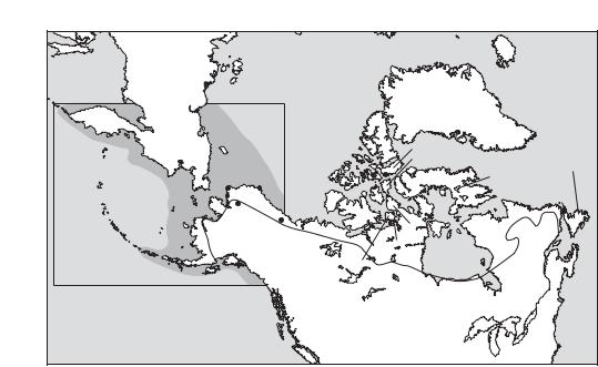
AMERICA 41
from the Aleutian Islands in the west to Greenland and Labrador in the east.
In terms of geomorphology, the Arctic includes high mountains, sedimentary plain, exposed bedrock and lowlands, most of it with little or no soil development. For humans, the winter landscape also includes the frozen sea ice. In Alaska, Greenland and Labrador this is often a wide strip of landfast ice along the coast, while in the Canadian Arctic Archipelago the channels between the islands freeze completely for much of the year. The Arctic is also characterized by the persistence of cold (long winters and short cool summers); permafrost (year-round frozen ground); large seasonal differences in the amount of sunlight; and by the paucity of plant foods suitable for humans.
Human populations in the Arctic have, of necessity, relied on animal resources to a far greater extent than foraging populations elsewhere. The most important terrestrial species are caribou, musk-ox, arctic fox and arctic hare, while the most important marine resources include seal, walrus, whale, polar bear and arctic char. Economically, most communities have made use of both terrestrial and marine resources, either through migrating through an ‘annual round’, encompassing land and sea, or through trade. Over time, the INUIT developed a complex technology to deal with their environment,
including snowhouses, toggling harpoons, large and small watercraft, drag floats and dog traction.
During the last glaciation, the westernmost part of the Arctic formed the uplands of BERINGIA, the first part of the Americas occupied by humans. However, most authorities agree that the earliest sites found in Alaska are somewhat later, and may
be assigned to the PALEO-ARCTIC TRADITION. This
is succeeded by the ARCTIC SMALL TOOL TRADITION (or ASTt), whose bearers also became the first humans to occupy the Canadian Arctic and Greenland. In Alaska, the ASTt is followed by the NORTON TRADITION, while in the Eastern Arctic it is followed by the DORSET CULTURE. The cultures of the THULE TRADITION developed in the area around the Bering Strait and subsequently spread, in part through population movement, throughout the entire Arctic region except the Aleutian Islands. The present-day Inuit peoples (i.e. the people formerly described as Eskimos) are the cultural and biological descendants of the Thule.
Despite the fact that archaeological research in the Arctic presents a number of unique challenges (including excavation into permafrost, short field seasons and immense logistical problems), it has made a number of valuable contributions to archaeology generally. The majority of Arctic research until the mid-1980s focused on filling gaps in its
A l
e
u
t i a
n
I s l a nds
|
|
ARCTIC |
|
|
|
|
|
|
OCEAN |
|
|
|
|
|
|
|
|
|
Greenland |
|
|
|
|
|
Ellesmere |
|
|
Siberia |
|
|
|
|
Devon |
|
|
|
|
|
|
|
|
|
Chukchi |
|
|
|
Somerset Island |
Newfoundland |
|
Sea |
|
Beechey Island |
|
||
|
|
Baffin |
Nettilling Lake |
|||
|
Point Hope |
Utqiagvik |
||||
|
|
|
L’Anse aux |
|||
|
Cape Krusenstern |
|
|
|
||
Bering |
Banks |
|
Meadows |
|||
Sea |
Onion |
|
|
Victoria |
|
Labrador |
|
|
|
|
|||
|
Portage |
Old Crow |
T |
|
Boothia |
|
|
|
|
|
|
||
|
|
ree l |
Peninsula |
|
||
|
Alaska |
Flats |
|
ine |
|
|
|
Adelaide |
Hudson |
|
|
Peninsula |
||
King William |
Bay |
||
|
|||
Island |
|
|
|
Kodiak Island |
|
|
The shaded area within the box shows very approximately the area of Beringia
Map 6 America, 1: Arctic North Major sites in the region with individual entries in the Dictionary.
42 AMERICA
culture history, but the extensive ethnographic literature documenting Inuit ways of life in the recent past has proved invaluable in interpreting the data recovered through archaeology, and in providing a basis for constructing models that can be tested utilizing the archaeological record. Human adaptations to the Arctic have generally employed a much more complex technology than that of foragers in lower latitudes, and at many sites the large material culture component of this technology has been preserved due to burial in permafrost. Given the rich ethnographic record, we can generally employ analogy with some confidence to understand the functions of the many artefact types and, by inference, the ecological significance of changes in technology over time. For these reasons, material culture has long been – and continues to be
– an important focus of Arctic archaeological research.
The North American Arctic has also provided an important context for ethnoarchaeology, perhaps the most influential example being Lewis Binford’s work in Alaska (e.g. MASK SITE). His studies of caribou hunting and butchering by the Nunamiut led him to develop his MIDDLE RANGE THEORY, which has the potential for linking patterns of archaeological findings with patterns of prehistoric behaviour. Specifically, Binford developed a method of analysing faunal remains based on a particular species’ ‘economic anatomy’, which is essentially a measure of the differential utility (such as nutritional value or percentage of bone to meat) of various anatomical portions of an animal carcass as determined by ‘ACTUALISTIC STUDIES’. Given that this set of relationships can be considered to have remained constant from the past into the present (as long as evolution has not significantly altered the anatomy of the species in question and basic human perceptions of these portions have not changed), the analysis of the anatomical portions represented in the faunal remains from an archaeological site can provide information concerning the economic behaviour of the people who produced the faunal assemblage.
Probably the most important contribution of Arctic archaeology derives from the nature of the Arctic environment itself and from the constraints that it imposes on human adaptations to this region. The extreme cold imposes unusually high energy requirements on humans living there, and these requirements were met almost exclusively by the consumption of meat obtained from hunting. These facts have led Moreau Maxwell (1985: 3) to argue that the archaeological data recovered from the Arctic provide ‘abundant materials for testing
hypotheses and propositions focused on the economies of ecology, that is, the way in which the energy is cycled through the food chain’. Thus, concepts like optimal FORAGING THEORY have proven particularly amenable to testing in the Arctic environment using both ethnographic and archaeological data.
L.R. Binford: Nunamiut ethnoarchaeology (New York, 1978); D. Damas, ed.: Handbook of North American Indians, V: Arctic (Washington, D.C., 1984); M.S. Maxwell: Prehistory of the Eastern Arctic (Orlando, 1985).
RP
2 Western North America
Western North America comprises an area of 2,577,000 sq. km west of the Rocky Mountains, south of the Yukon, and north of southern California. It was the home of an estimated 413,000 aboriginal peoples in the early 19th century (Kroeber 1939: table 18), by which time introduced diseases may have already reduced the size of the population. Population density per 100 sq. km varied from as little as one person in the desert regions of the Great Basin to as high as 95 in the Queen Charlotte Islands on the northern coast. Coniferous forests typify the coast from northern California to Alaska, and woodworking was highly developed. In the higher parts of the interior, pines predominated, whereas in low-lying areas vegetation varied from grass to sagebrush to desert. Seeds in the Great Basin and acorns in California were vital to subsistence. Major rivers breach the mountain ranges separating the interior from the coast and the anadromous salmon was the basic food resource on the coast and the interior plateaux.
The common feature of the aboriginal cultures in this area was that subsistence was based entirely on fishing, hunting, and gathering wild plant foods. Permanent winter villages (i.e. settlements with permanent structures serving as a home-base but normally fully occupied only during the winter months) with storage facilities and seasonal hunting or foraging camps were characteristic of those regions with large salmon runs or acorn harvests, whereas short-term seasonally occupied camp sites typified the less well endowed regions. The village was the basic socio-political unit in the former, and the band in the latter. Kinship and reciprocal obligations united people from adjacent villages and bands into social networks frequently referred to as ‘tribes’.
Technology varied, but the basic tool kit – the bow and arrow, harpoon, fish hook, nets for hunting or fishing, and the digging stick – was used everywhere. Stone-grinding tools were important in
seed-rich areas. Wood and basketry containers were widely used. The highest achievements in the arts and crafts were the monumental wood sculptures of northern coastal peoples, and the superb basketry of the central Californians. Spirit power and SHAMANISM typified the religious system. Archaeological research indicates that these ethnographic patterns extended far back into prehistory. Relative dating methods such as superposition and association and the comparative method underlie the chronologies and CULTURE HISTORY syntheses of this area. SYSTEMS THEORY, particularly cultural-environmental-demographic
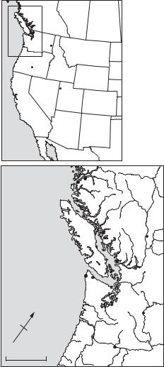
Area of main map
Lind Coulee
 Five Mile Rapids
Fort Rock Cave
 Dietz
Dietz
Danger
Cave
 Calico Hills
Pacific |
|
|
|
Ocean |
|
|
|
|
|
Namu |
Kwatna |
|
|
|
|
|
|
|
Keatley |
|
|
|
Creek |
Pacific |
|
|
Marpole |
Ocean |
|
|
|
|
|
Ozette |
Pender Canal |
|
|
|
|
|
|
|
Hoko |
N |
|
|
East |
|
|
|
|
|
|
|
Wenatchee |
0 |
200 km |
|
Five Mile |
|
Rapids |
||
|
|
|
Map 7 America, 2: Western North Major sites in the region with individual entries in the Dictionary.
AMERICA 43
interactions, has been used to guide some explanations of culture change, although models based on DIFFUSIONISM and migration are also employed. is widely used.
2.1.Cultural taxonomy. There are four culturally defined areas: the Northwest Coast, the ColumbiaFraser Plateau, the Great Basin, and Central California. A method of cultural classification based on propinquity and degree of similarity of artefact assemblages (Willey and Phillips 1958) is widely used. The concept of the ‘cultural tradition’, implying continuity of whole cultures through time, is the largest unit of synthesis and is applied both regionally and across western North America as a whole. Cultures are frequently subdivided into a number of chronological phases defined on the basis of some aspect of culture content – styles or frequencies of projectile points, burial types, houses etc. – which vary in one or more aspect from phase to phase. The term ‘component’ is widely used to refer to the expression of a phase at a particular site. For example, there are 18 components of the MARPOLE phase, which means that there are 18 spatially discrete assemblages assignable to the Marpole phase. Such components are usually from different sites, and the term ‘multiple component site’ means that there are components of more than one phase at the site.
2.2.Early period. The generally accepted chronology in all regions (except the Northwest Coast north of the Canada–United States border) places
the western FLUTED POINT TRADITION at the
beginning of the sequence. There is some debate as to whether this tradition is earlier or later than the
intermontane STEMMED POINT TRADITION. The
Fluted Point Tradition has estimated dates of 9500 to 9000 BC, based on CROSS-DATING with sites in eastern and southwestern North America. The majority of radiocarbon dates for the Stemmed Point Tradition, on the other hand, are between 8500 and 6000 BC, but there are dates from two sites, FORT ROCK CAVE (Bedwell 1973) and Smith Creek
Cave (Bryan 1988: 53–72) which if correct would place the beginning of this tradition earlier than 9500 BC. On the coast north of the United States–Canada border the PEBBLE TOOL TRADITION is the earliest, first attested at NAMU in c.7700 BC (Carlson 1991: 85–95). Further north in southeast Alaska the
radiocarbon-dated at HIDDEN FALLS to 7060 BC is the best-documented early cultural tradition (Davis 1989).
2.3. Middle period. From about 6000 BC to AD 1 was a time of cultural growth, technological exchange
44 AMERICA
among the earlier cultural traditions, increased efficiency in exploiting local environments, regional divergence, and growth of nuclear areas of cultural elaboration. During this time the atlatl remained in use, while atlatl projectile points notched for hafting superseded earlier fluted, stemmed, and foliate forms in most regions. Microblade technology spread south as far as the Columbia River by 4800 BC. The Namu data indicate that by 4000 BC salmon had become the staple item of subsistence on the Northwest Coast. The evidence from PENDER CANAL shows that by 1500 BC the Northwest Coast art style, the memorial potlatch, and advanced
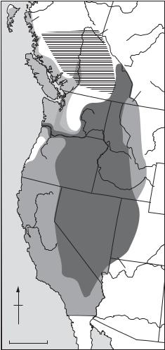
|
Pebble Tool |
|
Tradition |
|
Plateau Pithouse |
|
Tradition |
|
CANADA |
|
Fluted |
|
Point |
|
Tradition |
Pacific |
USA |
|
|
Ocean |
|
|
Stemmed |
|
Point Tradition |
N |
|
0 |
500 km |
|
MEXICO |
Map 8 America, 2: Western North Distribution of the four main cultural traditions in western North America (the Plateau Pithouse Tradition, the Pebble Tool Tradition, the Stemmed Point Tradition and the Fluted Point Tradition.
woodworking and social ranking had developed. In the Columbia-Fraser Plateau, permanent winter villages emerged by 3000 BC and by 2000 BC they became the norm with the development of the
PLATEAU PITHOUSE TRADITION. In the Great
Basin seasonal transhumance and exploitation of varied ecological niches with emphasis on seed gathering and hunting became the standard way of life. In California acorn processing with hoppermortars began, leading to the development of permanent villages and a considerable increase in population.
2.4. Late period. The late period, from AD 1 to European contact at about AD 1800, was characterized by further elaboration of the cultural patterns developed earlier, and the chief technological change was the replacement of the atlatl by the bow and arrow. Simple pottery vessels began to be made in the Great Basin, while ceramic figurines were produced both in the Great Basin and the lower Columbia River. Increased warfare and probably slavery occurred on the Northwest Coast. The cultures of the late period in western North America are typified by localized styles of artefacts such as arrow points, harpoon heads, seed-grinding tools and celts.
A.L. Kroeber: Cultural and natural areas of native North America (Berkeley, 1939); G. Willey and P. Phillips:
Method and theory in American archaeology (Chicago, 1958); S.F. Bedwell: Fort Rock Basin prehistory and environment (Eugene, 1973); M.J. Moratto, ed.: California archaeology (London, 1984); W.L. d’Azevedo, ed.:
Handbook of North American Indians II: Great Basin
(Washington, 1986); T.H. Richards and M.K. Rousseau:
Late prehistoric cultural horizons on the Canadian plateau
(Burnaby, B.C., 1987); A.L. Bryan: ‘The relationship of the stemmed point and fluted point traditions in the Great Basin’, Early human occupation in far western North America: the Colvis-Archaic interface, ed. J.A. Willig, C.M. Aitkens and J.L. Fagan (Carson City, 1988); S.D. Davis:
The Hidden Falls site, Baranof Island, Alaska, Alaska Anthropological Association Monographs Series (Fairbanks, 1989); W. Suttles, ed.: Handbook of North American Indians VII: Northwest Coast (Washington, 1990); R.L. Carlson: ‘Namu periodization and C-14 chronology’, The economic prehistory of Namu, ed. A. Cannon (Burnaby, B.C., 1991).
RC
3 Southwestern North America
The geographical ‘Greater Southwest’ region of North America lies within the area defined by 104°–115° west longitude and 29°–39° north latitude. A more informal and southern-oriented region is bounded by Las Vegas, New Mexico to Las Vegas, Nevada and Durango, Colorado to Durango, Mexico. The United States portion of