

A Dictionary of Archaeology
.pdfmay represent a relatively late ritual phase at Avebury, a few centuries after the construction of the main megalithic structures.
A. Burl: Prehistoric Avebury (London, 1979); A. Whittle: ‘A late Neolithic complex at West Kennet, Wiltshire, England’, Antiquity 65 (1991), 256–62.
RJA
Awat’ovi see ANASAZI
AXUM 95
funerary remains at Axum can contribute to the understanding of the function and symbolism of the Axumite stelae. Phillipson argues that the stelae served as grave-markers, representing a tradition which was modified after the people of Axum had adopted Christianity in the 4th century AD. He
axe-money Small bronze artefacts, apparently manufactured in northern Peru beginning c.AD 900 and traded to Ecuador for Spondylus shells.
D. Hosler et al.: Axe-monies and their relatives (Dumbarton Oaks, 1990).
KB
Axum City in the Ethiopian highlands, founded in the 3rd century AD, perhaps by migrants from southern Arabia. It was the capital and type-site of the Axumite culture. The remains include several groups of tall, narrow, stone stelae (up to 33 m in height), as well as tombs, monolithic platforms and urban material. The sites of three monumental multi-roomed buildings, known as Enda Mika’el, Enda Semon and Ta’akha Mariam, were excavated by a German expedition (Littmann et al. 1913). These massive structures, each standing on a masonry podium and consisting of up to three storeys, were identified by the excavators as the residences of the rulers of Axum. In 1966–8, a fourth structure, the ‘Dongur Mansion’, was excavated (Anfray 1972); this 40-room complex, covering an area of about 3000 square metres and dating to the 7th century AD, was interpreted as an elite ‘villa’ rather than a royal palace. Excavations elsewhere at Axum have revealed a number of smaller stone buildings, suggesting that it was an extensive urban site throughout the 1st millennium AD.
In the early 1970s a geoarchaeological study (Butzer 1981) and a settlement pattern survey (Michels 1979: 22-4) were conducted across a wide area around Axum. Both suggested that natural resources were unequally distributed in northeastern Ethiopia during the 1st millennium AD, leading to a distinct clustering of sites. Graham Connah (1987: 91) argues that population pressure brought about by differential access to resources in Axumite Ethiopia could have been a crucial influence on the course of Ethiopian history.
In the 1990s, the excavations of the British Institute of East Africa, directed by David Phillipson (1994), concentrated on the examination of the archaeological context of Stele 1, showing that the investigation of the impressive stone-built
Figure 6 Axum Granite stele, Axum, Ethiopia.
Source: G. Connah: African civilizations (Cambridge University Press, 1987), fig. 4.2.
96 AXUM
points out that, as the Axumite rulers were gradually Christianized, ‘erection of storeyed stelae was abandoned, but certain features of earlier graves and markers were retained, implying some continuity in underlying tradition’. See also ADULIS, MATARA
and YEHA.
E. Littmann et al.: Deutsche Aksum Expedition, 2 vols (Berlin, 1913); H. Monneret de Villard: Aksum: richerche di topografia generale (Rome, 1938); F. Anfray: ‘L’archéologie d’Axoum en 1972’, Paideuma 18 (1972), 60–78; J.W. Michels: ‘Axumite archaeology: an introductory essay’, Aksum, ed. Y.M. Kobishchanov (Philadelphia, 1979), 1–34; K. Butzer: ‘Rise and fall of Axum, Ethiopia: a geoarchaeological interpretation’, AA 46/3 (1981), 471–95; G. Connah: African civilizations, Precolonial cities and states in tropical Africa: an archaeological perspective
(Cambridge, 1987), 76–84; S. Munro-Hay: Aksum: an
African civilization of Late Antiquity (Edinburgh, 1991); D. Phillipson: ‘The significance and symbolism of Aksumite stelae’, CAJ 4/2 (1994), 189–210.
IS
Ayla/al-Aqaba Islamic urban site which was the port of Palestine and formed the link with the Red Sea as well as serving as a strategic point on the pilgrim road from Egypt to the Hijaz. Although urban remains had not been suspected at the site before excavations commenced in 1986, Ayla must now be regarded as comparable with such better-known foundations as al-FUSTAT, al-KUFA and al-Basra in terms of its archaeological importance for the understanding of early Islamic settlements.
The town was fortified, and such features as its
N |
|
|
|
|
|
|
|
|
|
|
|
|
|
|
|
S A U D I |
|
|
|
N |
|
i |
|
|
|
|
|
|
|
|
|
|
|
|
|
|
A R A B I A |
|
|
||||
l |
|
|
|
|
|
|
|
|
|
|
|
|
|
|
|
|
|||||
e |
S U |
D |
A |
N |
|
|
|
|
|
|
|
|
|
|
|
|
|
||||
|
|
|
|
|
|
|
|
|
|
|
|
|
|
|
|
|
|
||||
|
|
|
|
|
|
|
|
|
Red |
|
|
|
|
|
|
|
|
|
|
|
|
|
|
|
|
E R I T R E A |
|
|
|
Sea |
|
|
|
|
|
|
|
|
|
|
|
|
|
|
|
|
|
|
|
|
|
|
S |
A |
|
U |
D |
I |
|
|
|
|
|
||
|
|
|
|
|
|
|
|
|
|
|
|
|
|
|
|
|
|||||
|
|
|
|
|
|
|
|
|
|
|
Y |
E |
|
M |
E |
N |
|
|
|
|
|
Khartoum |
|
|
|
Agordat |
Adulis |
|
|
|
|
A R A B I A |
|
|
|
|
|||||||
|
|
|
|
Matara |
Kohaito |
|
|
|
|
|
|
|
|
|
|
|
|
|
|||
|
|
|
|
Yeha |
Debra Damo |
|
|
|
|
|
|
|
|
|
|
|
|
||||
|
|
|
|
Axum and Gobedra |
|
|
Addi Galamo |
|
|
|
|
|
|
|
|
|
|
|
|
||
|
|
|
|
Haoulti-Melazo |
|
|
|
|
|
|
|
|
|
|
|
|
|
|
|
|
|
|
|
|
|
Gondar |
|
|
|
|
|
|
|
|
|
|
Gulf of Aden |
|
|
|
|||
|
|
|
|
Gouzara |
Lalibela |
DJIBOUTI |
|
|
|
|
|
|
|
|
|
|
|
||||
|
|
|
|
Lalibela Cave |
|
|
|
|
|
|
|
|
|
|
|
|
|
|
|||
|
|
|
|
|
|
|
|
Hadar |
|
|
|
|
|
|
|
|
|
|
|
|
|
|
|
|
|
|
|
|
|
|
Awash |
Lago Oda |
|
|
|
|
|
S |
O M |
A |
L |
I |
A |
|
|
|
|
|
|
|
|
|
|
|
|
|
|
|
|||||||
|
|
|
|
Addis Ababa |
|
|
|
|
|
|
|
|
|
|
|
|
|
|
|||
|
|
|
|
Melka-Kunture |
|
|
|
|
|
|
|
|
|
|
|
|
|||||
|
|
|
|
|
|
|
|
|
|
|
|
|
|
|
|
|
|
|
|||
|
|
|
|
|
|
|
|
|
|
E |
T |
H |
I |
O |
P |
I |
A |
|
|
|
|
|
|
|
Omo |
|
|
|
|
|
|
|
|
|
|
|
|
|
|
|
|
|
|
|
|
|
|
Lake |
|
|
|
|
|
|
|
|
|
|
|
|
|
|
|
|
|
|
|
|
|
Turkana |
|
|
|
|
|
|
|
|
|
|
|
|
|
|
|
|
|
0 |
|
|
300 km |
K |
E |
N |
Y |
A |
|
|
|
|
|
|
|
|
|
|
|
|
|
|
|
|
|
K E N Y A |
|
|
|
|
|
|
|
|
|
|
|
|
|
||||
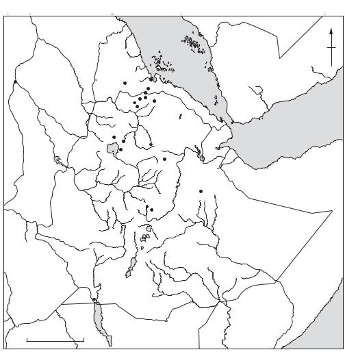
Map 18 Axum |
Prehistoric and Axumite sites in Ethiopia and Eritrea. |
|
|
|
|
|
|
|
|
|
|
|
|||||||||
towers, the organization of its gates and its central terapylon all recall Roman legionary camps in southern Jordan and Egypt. The site has been attributed to the reign of the third Caliph Uthman in about AD 650. Rising water has prevented the excavations reaching virgin soil, but there can be no doubt that the site’s discovery transforms the understanding of Umayyad and even pre-Umayyad activity in southern Palestine and Jordan. It also provides a focus for the study of the early Islamic period in the Red Sea, an area that has been neglected by archaeologists.
D. Whitcomb: ‘Excavations in Aqaba: first preliminary report’, ADAJ 31 (1987), 247–66; ––––: ‘A Fatimid residence in Aqaba, Jordan’, ADAJ 32 (1987), 207–24; ––––:
‘The Misr of Ayla: settlement of al-ðAqaba in the early Islamic period’, The Byzantine and early Islamic Near East II: land use and settlement patterns, ed. G.R.D. King and A. Cameron (Princeton, 1994), 155–70.
GK
Ayn Asil see DAKHLA OASIS
Ayutthaya Capital of the Thai kingdom, founded by King U-Thong or Ramathibodi in AD 1351, and sacked by the Burmese in 1767. Located on the Chao Phraya River, 50 km north of Bangkok, it was the centre of Thai power and culture for four centuries. It was, however, prone to attacks by the Burmese, suffering a major setback when it was destroyed and sacked in 1569. Under King Narai (1656–88), however, the Thais entered a period of strong diplomatic and trade relationships with the West. A 17th-century plan prepared by de la Loubére, a member of a French diplomatic mission, shows the location of the royal palace, the arsenal, port, market and area occupied by the populace. There were also buildings of the Dutch, Portuguese and French missions. After its final destruction in 1767, the Thai leadership retreated to the marshy delta of the Chao Phraya river in the vicinity of Bangkok.
D.K. Wyatt: Thailand, a short history (New Haven, 1984), 61–9.
CH
Azania see HAFUN; RHAPTA
Azilian Industry or ‘culture’ transitional between the Upper Palaeolithic (Magdalenian) and Mesolithic, c.10,000–7000 BC. Because the Azilian appears at the end of the last glaciation it has traditionally been regarded as marking the beginning of cultural and technological adaptions to a postglacial environment. The Azilian was first
AZILIAN PEBBLES 97
excavated in 1874 at Abri Duruthy in France (Landes), but MAS D’AZIL (Ariège) and La Tourasse (Haute-Garonne) are regarded as its type-sites. The character of an Azilian assemblage has never been strictly defined; many definitions are essentially negative, stressing the poverty of Azilian lithic industries in comparison to the Magdalenian (which may be partly due to a tendency to use lower-grade flint) and the paucity of its art. The strongest positive indicators are flat single-row Azilian harpoons (often with button-hole perforations) and curious painted AZILIAN PEBBLES. Where these indicators are absent Azilian assemblages are identified by their high proportion of backed bladelets and small end-scrapers; a low (but variable) proportion of burins; and the presence of Azilian points (double-pointed backed blades). Because the character of the Azilian is indistinct at both chronological ends, there has been a proliferation of terms such as ‘Azilian-like’ or ‘epiAzilian’. ‘Azilian’ points and even flat harpoons are found in Magdalenian contexts (Bahn), while a probable chronological overlap with ‘true’ Mesolithic entities such as the Asturian has led to suggestions of a complex relationship (see
ASTURIAN).
P. Bahn: Pyrenean prehistory (Warminster, 1984), 45; J.A. Fernández-Tresguerres Velasco: ‘Thoughts on the transition from the Magdalenian to the Azilian in Cantabria: evidence from the Cueva de Los Azules, Asturias’, The mesolithic in Europe, Papers presented at the Third International Symposium, Edinburgh, ed. Clive Bonsall (Edinburgh, 1985), 582–8; L.G. Strauss: Iberia before the Iberians (Albuquerque, 1992), 194–216, 227–9.
RJA
Azilian pebbles The AZILIAN is characterized by the replacement of the rich naturalistic mobiliary and parietal art of the preceding Magdalenian with a rather limited art of a much simpler geometric style. This art is occasionally manifested on bone tools, but most characteristically on the famous painted and occasionally engraved Azilian pebbles found in great concentrations at MAS D’AZIL and Rochdane in France; examples are also known from another 35 sites in France, Spain, Switzerland and Italy. Single and multiple dots and strokes running across the width of the pebbles are the most common motifs; more complex designs include crosses, wavy lines, and longitudinal lines hatched with short strokes. The motifs are usually painted in red, or occasionally black, but some are engraved. D’Errico’s examination of engraved pebbles has cast doubt on suggestions that the dots and strokes represent some kind of hunting tally or lunar cycle
98 AZILIAN PEBBLES
notation; however the repeated combinations of motifs does seem to some extent to be ordered, which may suggest a simple syntax.
C. Couraud and P. Bahn: ‘Azilian pebbles in British collections: a re-examination’, PPS 48 (1982), 45–52; C. Couraud: L’art Azilien: origine, survivance, XXe supplément à Gallia Préhistoire (Paris, 1985); F. D’Errico: ‘Palaeolithic lunar calendars: a case of wishful thinking?’,
CA 30/1 (1989), 117–18; ––––: L’art gravé Azilien: de la technique à la signification (Paris, 1994).
RJA
Azmak, Tell Settlement mound 6 km east of Stara Zagora in Bulgaria, formed between the 5th and 3rd millennium BC. Excavations between 1960 and 1963 by Georgi Georgiev provided a vital cultural sequence for the Neolithic and the Eneolithic of Bulgaria. Georgiev identifies the Azmak phases as equivalent to KARANOVO phases I, III, V, VI and VII. The earliest houses were rectangular and square in plan, and made of claycovered wicker supported by posts; the inner walls of houses from Azmak Neolithic II and Azmak Eneolithic IV were painted with geometric patterns. The pottery from most of the Neolithic period is polished with mainly white geometric decoration on a red ground (Karanovo I), while the sides of some of the later Neolithic vessels were enlivened with small figures in relief. Schematic figurines in bone, clay and marble were discovered in all levels, including one particularly fine marble example from Neolithic I.
G. Georgiev: ‘The Azmak mound in southern Bulgaria’, Antiquity 39 (1965), 6–8.
RJA
Aztalan Late prehistoric ‘mound center’ located on the bank of the Crawfish River in southern Wisconsin, eastern North America. An embankment and a strong wooden palisade with regularly spaced bastions once encompassed an area of about 9 ha, several earthen mounds, a plaza and living areas. Additional mounds are located on high ground near the site, but outside the palisade. At its peak, in about AD 1100–1300, Aztalan had strong ties to more southerly MISSISSIPPIAN sites, particularly CAHOKIA. It has long been regarded as an outlier in the overall geographical distribution of Mississippian sites.
L.G. Goldstein and J.D. Richards: ‘Ancient Aztalan: the cultural and ecological context of a late prehistoric site in the Midwest’, Cahokia and the hinterlands: Middle Mississippian cultures of the Midwest, ed. T.E. Emerson and R.B. Lewis (Urbana, 1991).
GM
Aztecs More properly known as the Mexica, the Aztecs were late migrants into central Mexico and came to dominate much of western Mesoamerica during the Late Postclassic period (AD 1200–1521). According to Mexica myth and history, which emphasize their humble CHICHIMEC origins, they left their home of Aztlán (whence the name Aztec) and arrived in the BASIN OF MEXICO at some time in the late 13th or early 14th century. A despised, nomadic group, led by their patron deity Huitzilopochtli and serving as mercenaries for the more powerful indigenous city-states in the basin, the Mexica finally (c.AD 1325) settled successfully on an island in the western part of Lake Texcoco and established what would become their capital, Tenochtitlán. It covered an area of approximately 12 sq. km, with a population estimated at 125,000–200,000. Likened by early European visitors to Venice, the island was criss-crossed by a system of canals that facilitated easy canoetransport on the lake and throughout the basin. There were two main ceremonial precincts on the island, the largest having some 72 buildings, including temples, priests’ quarters, ball-courts (see BALLGAME), COATEPANTLI (‘serpent-walls’) and tzompantli (‘skull-racks’). The principal temple, known today as the ‘Templo Mayor’, had twin structures dedicated to the gods Huitzilopochtli and Tlaloc; it was rediscovered by accident in 1978 during subway construction in central Mexico city. During the following five years the multidisciplinary investigations of Mexican archaeologists, biologists and geologists at the Templo Mayor (Matos Moctezuma 1988) revealed a great complex of buildings including a tzompantli, a CHACMOOL, sculptures, ceramics and several smaller temples.
During the 14th and 15th centuries the Aztecs developed political and marital ties with their more powerful neighbours. In 1430 the NAHUATL- speaking Mexica became part of and eventually dominated an alliance with two of these polities, the Acolhua of Texcoco and the Tepanecs of Tlacopan. This ‘Triple Alliance’ was the core of the ‘Aztec empire’ which expanded throughout western Mesoamerica during the following century.
The area dominated by the Triple Alliance included some 50–60 city-states in central Mexico, with an estimated total population of 1–2.5 million people. In addition, the ‘empire’ incorporated about 40 conquered tributary provinces in the hinterland, representing approximately 5–6 million people. There is considerable argument about the degree to which this can truly be considered an empire (Conrad and Demarest 1984: 11–83; Smith 1986),
for Triple Alliance control of these distant areas was weak, provincial rebellions were frequent and there was no standing imperial army. In addition, local dynasties were usually allowed to maintain their position after marriage to a member of one of the royal families of the Triple Alliance. The primary objective of imperial expansion seemed to be the incorporation of new populations from which to draw regular payments of tribute. This expansion was aided by regular reports, from pochteca, or long-distance traders, who some scholars claim acted as state agents in their travels throughout Mesoamerica and provided estimates of the tributepaying potential of distant regions. Tribute coming in from the conquered provinces was itemized in lists, such as the Codex Mendoza, which reveal that Triple Alliance demands were staggering: literally tons of corn, beans, amaranth, CACAO and countless other goods poured into Tenochtitlan as part of annual assessments.
Among the most famous – or infamous – features of Aztec society were the practices of human sacrifice and cannibalism. Although argued by some to be strategies for adding protein to an otherwise meat-deficient diet (see Harner 1977), there is broader agreement that human sacrifice and cannibalism were ritual practices. Aztec religion demanded regular offerings of blood to nourish the sun god and maintain the universe, and the sacrifice of brave warriors was the offering of choice. Warriors and other sacrificial victims were sanctified through this act and it was a special privilege for the living to consume their flesh. Although the Aztecs apparently suffered several famines, during which they consumed all the grain stored in their storehouses, there is virtually no evidence supporting protein deficiency given the ready availability of fish, game and domesticated dogs.
Hernán Cortés and his army, accompanied by the enemies of the Aztecs, the people of Tlaxcala, arrived in the Basin of Mexico in 1519. After a series of skirmishes and retreats, the Spaniards conquered the Aztecs in 1521 by attacking the island
AZYKH CAVE 99
capital from a boat and maintaining siege for 90 days.
G.C. Vaillant: Aztecs of Mexico (New York, 1966); N. Davies: The Aztecs, a history (Norman, 1973); E.E. Calnek: ‘The internal structure of Tenochtitlan’, The valley of Mexico, ed. E.R. Wolf (Albuquerque, 1976) 287–302; M. Harner: ‘The ecological basis for Aztec sacrifice’, American Ethnologist 4 (1977) 117–35; F.E. Berdan: The Aztecs of central Mexico, an imperial society (New York, 1982); G.W. Conrad and A. Demarest: Religion and empire (Cambridge, MA, 1984); M. Smith: ‘The role of social stratification in the Aztec empire: a view from the provinces’, American Anthropologist 88 (1986) 70–91; E. Matos Moctezuma: The great temple of the Aztecs: treasures of Tenochtitlan (London, 1988); S.D. Gillespie: The Aztec kings: The construction of rulership in Mexica history
(Tucson, 1989); I. Clendinnen: Aztecs (Cambridge, MA, 1991).
PRI
Azykh Cave Stratified cave site with early Palaeolithic sequence, situated on the southern slopes of the Little Caucasus, in the Nagorno– Karabakh region (Azerbaidjan/Armenia). Pebblebased industries, reminiscent of the Oldowan in Eastern Africa (see OLDUVAI), were discovered in the lower levels; these have shown the inverse magnetic polarity identified as the Matuyama palaeomagnetic epoch (before 735,000 BP). The overlaying strata contained ACHEULEAN- and MOUSTERIAN-type industries. In 1968, a fragment of a mandible of a hominid (Azykhanthropus) was found in the Acheulean layer of the Azykh Cave; it is generally viewed as belonging to a ‘PRE-
NEANDERTHAL’ species.
A.A. Velichko et al.: ‘Paleogeografija stojanki Azyh – drevneišego poselenija pervobytnogo cˇeloveka na territorii SSSR’ [‘Palaeogeography of the Azykh site – the oldest dwelling site in the territory of the USSR’], Izvestiya AN SSSR. ser. geograf., (1980/3), 20–35; V.P. Lyubin: ‘Paleolit Kavkaza’ [The Palaeolithic of the Caucasus],
Paleolit Kavkaza i Severnoi Azii [The Palaeolithic of the Caucasus and Northern Asia], ed. P.I. Boriskovsky (Leningrad, 1988), 9–142.
PD

B
Babadan A One of a series of Early Palaeolithic sites in Miyagi prefecture. The oldest well-dated site in Japan, it ended the long-standing controversy over the dating of the Japanese Early Palaeolithic (pre-30,000 BP). Circular scrapers, awls, knifeshape tools and gravers of agate and chalcedony were found on a surface overlain by a pumice layer dated by TEPHROCHRONOLOGY to c.130,000 BP.
M. Okamura: ‘Babadan A’, Ancient Japan, ed. R. Pearson (Washington, D.C., 1992).
SK
Babel, Tower of see BABYLON
Babylon (Hilla) The ancient site of Babylon (Akkadian: ‘gate of the gods’), located in southern Iraq 80 km south of Baghdad, was initially only a provincial city during the Ur III period (c.2150–2000 BC), but it flourished from the reign of Hammurabi (c.1792–50 BC) until Sasanian times (c.AD 224–651). At about 850 ha, Babylon was the largest ancient Mesopotamian city; it was first identified correctly by Claudius James Rich and then excavated by Austin Henry Layard in 1850. The most significant excavations were undertaken by Robert Koldewey in 1899–1917 and by German and Iraqi archaeologists from 1958 onwards. The height of the water-table has tended to restrict most excavation to the Neo-Babylonian (CHALDAEAN) dynasty (c.625–539 BC), when the political power of the Babylonians probably reached its greatest height.
For the First Dynasty of Babylon (c.1894–1595 BC) other sites have proved more informative, particularly MARI, Tell Shimshara and Tell el-Rimah, where both excavation of houses and temples and the translation of surviving royal archives of thousands of cuneiform tablets have provided invaluable evidence concerning the society, economy, administration and religion of the Old Babylonian period. Although the Babylonian elite arrived in Mesopotamia as late as the end of the 3rd millennium BC (probably originating in the desert to the west of Babylon), they were Semitic speaking
and readily adopted the customs of the indigenous peoples: the art, architecture and writings of Babylonia are therefore very much within the Mesopotamian tradition.
In the Neo-Babylonian period, the city of Babylon was surrounded by a large, baked-brick inner wall as well as an extremely long outer wall with a circumference of some 8 km, which is described by Herodotus. The inner city, divided into eastern and western sectors by the Euphrates, was entered via eight gates, each named after a deity, the most elaborate of which was the Ishtar Gate, with its facade of coloured glazed bricks. Immediately to the west of this gate was the southern palace, built by the neo-Babylonian ruler Nebuchadnezzar II (c.604–562 BC) and possibly the site of the Hanging Gardens. It was in this building that Belshazzar (c.550 BC) may perhaps have witnessed the Biblical ‘writing on the wall’, and where Alexander the Great is supposed to have died. The principal buildings in the city would originally have been the ziggurat and temple dedicated to Marduk, the most important Babylonian deity, although ironically the ziggurat – which was called Etemenanki but was almost certainly the original ‘Tower of Babel’ – has now been reduced to a shapeless pit.
R. Koldewey: The excavations at Babylon (London, 1914); H. Figulla and W.J. Martin: Letters and documents of the Old Babylonian period (London and Philadelphia, 1953); J. Oates: Babylon, 2nd edn, (London, 1986); H.W.F. Saggs: The Babylonians (London, 1995).
IS
Babylonia see BABYLON
backed blade Flint blade with at least one edge blunted by secondary retouch, apparently to allow the tool to be handled more comfortably. Backed blades were first produced in the early Upper Palaeolithic, and curved backed blades (Châtelperron points) are diagnostic of the CHÂTELPERRONIAN (Lower Périgordian).
RJA
Bacsonian Culture identified in the province of Bac Son in north Vietnam in the 1920s by the French archaeologist Henri Mansuy. The sites, comprising small rock shelters from which both forest and aquatic resources were exploited by mobile foragers, were located in the limestone uplands on the northern border of the Red River delta, and have been dated to c.5000–8000 BC. They were distinguished from the contemporary HOABINHIAN culture by the greater incidence of edge-ground stone artefacts – an innovation which preceded the first evidence for the use of pottery. The rock shelters contrast with the larger, permanent settlements of farmers found in coastal locations from about 4000 BC (e.g. Quynh Van), once the sea level
– which had risen rapidly in the Holocene period –
stabilized (see COASTAL NEOLITHIC).
H. Mansuy: ‘Stations préhistoriques dans les cavernes du massif calcaire de Bac-Son (Tonkin)’, BSGI 11/2 (1924).
CH
el-Badari Area of Upper Egypt stretching for about 30 km between Matmar and Qau, where numerous predynastic cemeteries are located. These include Mostagedda, Deir Tasa and the cemetery of el-Badari itself, as well as at least one early settlement at Hammamia. The region was first investigated by Guy Brunton and Gertrude CatonThompson between 1922 and 1931. Many of the finds from this region constitute the original basis for the ‘Badarian period’, the earliest phase of the Upper Egyptian predynastic sequence (c.5500–4000 BC; see EGYPT 1). The Badarian graves have yielded distinctive pottery vessels (particularly red-polished ware with blackened tops), as well as terracotta and ivory anthropomorphic figures, slate palettes, stone vases and flint tools. The assemblages of funerary equipment from the predynastic cemeteries at el-Badari have been subjected to a number of statistical analyses attempting to clarify the chronology and social history of the Badarian period (e.g. Kaiser 1985).
The Badarian settlement of Hammamia was first examined by Gertrude Caton-Thompson in the 1920s. Her pioneering approach to the site involved a wide survey area across the surrounding desert, which amounted to an early form of
(not usually supposed to have been introduced until the work of Higgs and VitaFinzi in the late 1960s). Her excavation of about half of the area of stratified predynastic settlement remains at Hammamia was unusually meticulous and systematic; she divided the site into strips of 5 × 10 m squares and excavated them in arbitrary 30 cm levels. She provided the first stratigraphic
BAGOR 101
confirmation of Petrie’s cemetery-based predynastic ‘sequence dates’ (see SERIATION).
In 1989 Diane Holmes and Renée Friedman reexamined the predynastic sites in the el-Badari region, finding that 50% of them were being affected by modern activities, some having been completely destroyed. This project, which also included a number of small test excavations, is a rare instance of the application of a CRM (cultural resource management) approach to an Egyptian site. Caton-Thompson had suggested that the small quantities of Amratian pottery found at Hammamia, deriving from strata amounting to only about 5% of the total depth of deposits, were an indication that the site had gone into temporary decline during the Amratian period (c.4000–3500 BC). Holmes and Friedman (1989), however, argue (on the basis of two test-pits in Caton-Thompson’s strip ‘H’) that the relative dearth of Amratian ceramics may actually be an indication that the Badarian ceramics were more of a regional tradition and that the Badarian period may therefore have overlapped chronologically with the Amratian.
G. Brunton et al.: Qau and Badari, 3 vols (London, 1927–30); G. Brunton and G. Caton-Thompson:
The Badarian civilization and prehistoric remains near Badari (London, 1928); ––––: Mostagedda and the Tasian culture (London, 1937); ––––: Matmar (London, 1948); G. Caton-Thompson and E.H. Whittle: ‘Thermoluminescence dating of the Badarian’, Antiquity 49 (1975), 89–97; W. Kaiser: ‘Zur südausdehnung der vorgeschi-chtlichen Deltakulturen und zur frühen Entwicklung Oberägyptens’, MDAIK 41 (1985), 61–87; D.L. Holmes and R.F. Friedman: ‘The Badari region revisited’, Nyame Akuma 31 (1989), 15–18; D.L. Holmes: ‘Archaeological cultural resources and modern land-use activities: some observations made during a recent survey in the Badari region, Egypt’, JARCE 29 (1992), 67–80.
IS
Badarian see EL-BADARI; EGYPT: PREHISTORIC
baetyls see LOS MILLARES
Baghdad see ISLAMIC ARCHAEOLOGY
Bagor Open-air site located on an ancient sand dune along the Kothari River in eastern Rajasthan, India, excavated by V.N. Misra. Three chronological phases were defined. In Phase I, radiocarbon dated to c.5300–3800 BC, chert microlithic tools were associated with domestic sheep/goat, and wild fauna, providing early evidence for animal domestication in Rajasthan. Structural remains include stone pavements and circular stone alignments, perhaps hut foundations. In Phase II, MICROLITHIC
102 BAGOR
tools continued, handmade pottery appeared, and copper arrowheads with affinities to artefacts of the contemporary INDUS CIVILIZATION have been found, perhaps implying trade or contact. Two radiocarbon dates are available from this period: c.3395–3160 BC and c.2645–2310 BC (Possehl and Rissman 1992:477). Phase III is characterized by historic pottery and iron fragments, dated (on the basis of artefact form) to c.600 BC–AD 200. Burials are found from all three phases, associated with the habitation area.
V.N. Misra: ‘Bagor: A late Mesolithic settlement in northwest India’, WA 5 (1973), 92–100; G.L. Possehl and P. Rissman: ‘The chronology of prehistoric India: from earliest times to the Iron Age’, Chronologies in Old World archaeology I, ed. R.W. Ehrich (Chicago, 1992).
CS
Bahariya Oasis Fertile depression in the Libyan Desert, located about 200 km west of the Nile, which was occupied by Egyptians from at least as early as New Kingdom until the Roman period (c.1500 BC–AD 395). One of the most significant sites in the region is a group of tombs of 26th-dynasty (c.600 BC) Egyptian governors of the oasis situated near the modern town of Bawit. The site of el-Hayz, at the southern end of the oasis, consists of a Roman garrison, a basilica and a small settlement dating to the Roman and Christian periods (c.30 BC–AD 641). In the immediate vicinity of Bawit are a number of other sites, including the 19th-dynasty tomb of the provincial governor Amenhotpe Huy (c.1250 BC), a necropolis of sacred birds associated with the worship of the gods Thoth and Horus (dating to the 26th dynasty and Ptolemaic and Roman periods), the remains of a Roman triumphal arch and two temples dating to the 6th and 4th centuries BC respectively.
A. Fakhry: Bahria oasis, 2 vols (Cairo, 1942–50); ––––: The oases of Egypt II (Cairo, 1974); L. Giddy: Egyptian oases: Bahariya, Dakhla, Farafra and Kharga during pharaonic times (Warminster, 1987).
IS
Bahia and Jama-Coaque Two closely related cultures on the central coast of Ecuador, dating to the Regional Development Period (500 BC–AD 500). They are best known from their elaborate figurines of musicians, dancers and members of the elite with exotic costumes and a wealth of jewellery. High tides at Los Esteros near Manta uncovered a pyramid with a large number of these figures arranged along the stages, looking out to sea; otherwise, little is known of the contexts of the figures or of other aspects of these cultures. They do, how-
ever, present the most detailed evidence of costume, ornament, and the gender and occupational associations of these to be found in the northern Andes. Regional surveys in the Jama Valley combined with site testing and paleobotanical investigations are slowly adding a cultural setting to the figurines.
T. Cummins: ‘La tradición en el arte prehispanico Ecuatoriano: la cerámica de Chorrera y Jama-Coaque’,
Signos Amerindios: 5000 años de arte precolombino en Ecuador, ed. F. Valdez and D. Veintimilla (Paris, 1992), 63–81; T. Zeidler and D. Pearsall, ed.: Regional archaeology in northern Manabí, Ecuador I: Environment, cultural chronology, and agricultural production (Pittsburgh, 1993).
KB
Bahrain (anc. Dilmun) Island in the Persian Gulf where remains dating from the Palaeolithic to the Islamic period have been excavated. From the late Uruk period (c.3500–3100 BC) onwards the name Dilmun was used in southern Babylonian cuneiform texts to refer to the eastern Arabian mainland, where goods from the east were obtained by trade. By the late 3rd millennium BC, however, the term was applied to Bahrain alone, since it had apparently become the most convenient entrepot for trade-goods from the Oman peninsula, Iran and the INDUS CIVILIZATION. The principal preIslamic sites on Bahrain include the temple at Barbar dating to c.2200–1500 BC; the fortified city at Rañs al-Qalñat; a ‘well-temple’ at Diraz; the burial mounds at Rifaña dating to the late 3rd millennium BC (the earliest major cemetery on the island), and a town with central temple as well as cemeteries in the region of Sar (thousands of burial mounds dating from the late 3rd millennium BC to the 3rd century AD).
T.-G. Bibby: Looking for Dilmun (New York, 1970); D.T. Potts, ed.: Dilmun: new studies in the archaeology and early history of Bahrain (Berlin, 1983); H.A. al-Khalifa Shaika and M. Rice, eds: Bahrain through the ages: the archaeology
(London, 1986); H. Crawford: ‘Dilmun reconsidered’, Antiquity 71 (1997), 701–8.
IS
Balambai see GANDHARA GRAVE CULTURE
Balat see DAKHLA OASIS
Balawat, Tell (anc. Imgur-Enlil) Assyrian city site in northern Iraq, 16 km north of TELL NIMRUD. The site is best known for the 16 embossed bronze bands surviving from the massive gates erected by the late Assyrian ruler Shalmaneser III (c.858–824 BC), each leaf of which measured 4 × 2 m; the figurative designs accompanied by cuneiform inscriptions depict Shalmaneser’s major exploits,
including a journey to the ‘source’ of the Tigris (i.e. a point where it disappears underground for several kilometres) and the campaigns against the Urartians and Chaldaeans. The first unprovenanced fragments of the gate appeared on the art market in 1876, and in 1877–8 Hormuzd Rassam excavated at Tell Balawat, discovering further fragments as well as the remains of another gate erected by Shalmaneser’s father, Ashurnasirpal II. However, doubt was unjustifiably cast on Rassam’s work, and it was not until fragments of another bronze gate, again dating to the time of Ashurnasirpal II, were excavated, that the origins of the gates of Shalmaneser were placed beyond any question (see Lloyd 1980).
H. Rassam: Asshur and the land of Nimrod (New York, 1897), 207–8; L.W. King: Bronze reliefs from the Gates of Shalmaneser (London, 1915); M. Mallowan: Twenty-five years of Mesopotamian discovery (London, 1956), 79; S. Lloyd: Foundations in the dust: the story of Mesopotamian exploration, 2nd edn (London, 1980), 150–4; J. Curtis: ‘Balawat’, Fifty years of Mesopotamian discovery, ed. J. Curtis (London, 1982), 113–19.
IS
Ballana Post-Meroitic Nubian cemetery located some 15 km south of ABU SIMBEL, Egypt. It is the type-site of the Ballana (or X-Group) period, which lasted from the decline of the MEROITIC empire in c.AD 350 to the arrival of Christianity in Nubia in c.AD 550. Both Ballana and the nearby contemporary cemetery of Qustul were excavated in the 1930s (Emery and Kirwan 1938) but they are now submerged under LAKE NASSER. Many of the distinctive tumulus burials at Ballana and Qustul, nearly 200 of which were excavated, contain evidence of human sacrifice in the form of the bodies of retainers buried alongside the pre-Christian rulers of Lower Nubia. The drift sand and low scrub covering the tumuli at Ballana has helped to preserve the graves from the widespread plundering that affected the earlier elite Kushite cemeteries
of MEROE and NAPATA.
W.B. Emery and L.P. Kirwan: The royal tombs of Ballana and Qustul (Cairo, 1938); B.G. Trigger: ‘The Ballana culture and the coming of Christianity’, Africa in Antiquity: the arts of ancient Nubia and the Sudan I, ed. S. Wenig (New York, 1978), 107–11; W.Y. Adams: Nubia: corridor to Africa, 2nd edn (Princeton, 1984), 404–13; B. Williams: Excavations between Abu Simbel and the Sudan frontier IX: Noubadian X-Group remains from royal cemeteries, (Chicago, 1991).
IS
ballgame Ritual game played with a rubber ball throughout Mesoamerica from the Preclassic
BALSA 103
period (c.2500 BC) until recent times. Variants of the game spread southward as far as Costa Rica, northward into the southwestern United States and eastward into the Caribbean. In prehispanic Mesoamerica the game was played in rectangular fields or courts with vertical or sloping walls, usually of masonry at the larger sites. In some areas the architecture was elaborated with goal-like rings on the walls and carved markers in the playing floor. Depictions of the ballgame on ceramic vessels show players wearing elaborate ornamental and/or protective paraphernalia on the head, waist and limbs. Many variants of the soccer-like game existed in terms of numbers of players, rules of play, scoring and consequences of loss or victory (which often involved human sacrifices). All of these characteristics suggest that the Mesoamerican ballgame was a ceremonial activity carried out by elites. While it is occasionally considered to have been pure sport, more common interpretations focus on such phenomena as celestial/calendrical ritual, cycles of death and renewal (especially agricultural), symbolic warfare and dynastic celebrations.
V.L. Scarborough and D.R. Wilcox, eds: The Mesoamerican ballgame (Tucson, 1991); L. Schele and Mary Ellen Miller: The blood of kings: Dynasty and ritual in Maya art (London, 1992).
PRI
Balof Cave Limestone doline (sink-hole) on northern New Ireland, Papua New Guinea, with occupation horizons from 15,000 years ago through to the present. The site probably represents a campsite, and reveals the changing range of animals that were hunted; it also provides evidence for the introduction of animals, such as the cuscus (Flannery and White 1991). The raw material for the tools may have been obtained some distance from the site: the obsidian certainly derives from TALASEA.
T.F. Flannery and J.P. White: ‘Animal translocations’,
National Geographic Research and Exploration 7 (1991), 96–113; J.P. White et al.: ‘The Balof shelters, New Ireland’, Report of the Lapita Homeland Project, ed. J. Allen and C. Gosden (Canberra, 1991), 46–58.
CG
balsa South American log raft generally made of the very light-weight wood of Ochromo piscatoria, a tree found in coastal Ecuador. Balsas were first developed for river transport, but in late prehistory became very large and were utilized in trade passing along the coast from southern Colombia to northern Peru and, perhaps, further afield.
J. Estrada: La balsa en la historia de la navegación Ecuatoriana (Guayaquil, 1990).
KB
104 BALSA
Bambandyanalo Part of a complex of Iron Age sites (Mapungubwe, Bambandyanalo, K1 and K2), which are perhaps more correctly referred to as K2, located on the farm Greefswald in the northwestern Transvaal, South Africa, just south of the confluence of the Shashi and Limpopo Rivers. K2 is the oldest of the localities, being settled by c.AD 950 and abandoned by c.1070, although K2-type occupation continued on the southern terrace of MAPUNGUBWE HILL. In its earliest stages the K2 settlement covered a very large area, surrounding a large central cattle kraal. Later, the cattle were kraaled elsewhere and an enormous ash heap accumulated over the old kraal area, to a depth of 6 m. Sanga and Afrikander cattle, sheep and goats were important, and the domestic dog was present. Agriculture was practised from the beginning. Iron and copper were smelted and ivory was both traded (to Arabs in exchange for beads) and used extensively for personal adornment. Human burials and several cattle burials were found in the ash mound. Trade beads were re-processed on the site, to make large cylindrical beads.
G.A. Gardner: Mapungubwe II (Pretoria, 1963); E.A. Voigt: ‘Iron Age herders of the northern Transvaal, South Africa, in the first millennium AD’, Animals and archaeology 3: early herders and their flocks, ed. J. Clutton-Brock and C. Grigson (Oxford, 1984).
RI
Bambata pottery Thin, extensively decorated pottery first found overlying WILTON deposits in Bambata Cave in the Matopos hills of Zimbabwe. Later excavations yielded a caprine tooth and a date of 90 BC, although the association is not secure. Archaeologists have found Bambata pottery with Late Stone Age material in open sites around the Makadikadi pans in Botswana and in rock shelters with post-classic Wilton in the Waterberg and Magliesberg mountains of the Transvaal. As a rule the stone industries remain unchanged and the style lacks local antecedents; the pottery is therefore a ‘trait intrusion’. Consequently Bambata figures in debates about moving frontiers and the origins of pastoralism in southern Africa. Huffman places it within the Kalundu Tradition (see AFRICA 4) and believes it is part of BENFICA rather than a style of its own. A village site dated at AD 150 at Toteng in Botswana yielded domestic cattle as well as small stock. Independent climatic evidence suggests it was drier at this time, and cattle may have been brought through open savanna along the Congo coast from Cameroon.
J.F. Schofield: ‘A report on the pottery from Bambata Cave’, SAJS 37 (1941), 361–72; N.J. Walker: ‘The signifi-
cance of an early date for pottery and sheep in Zimbabwe’, SAAB 38 (1983), 88–92; J. Denbow: ‘A new look at the later prehistory of the Kalahari’, JAH 27 (1986), 3–28; T.N. Huffman: Iron Age migrations: the ceramic sequence in southern Zambia ( Johannesburg, 1989).
TH
Bamboo Annals (Chu-shu-chi-nien, Zhushujinian) Chronological list of Chinese rulers with brief records of major events concerning each reign. These annals originally comprised brushwritten tablets of split bamboo found among the plunder of a tomb which, at the time (c.AD 280), was thought to have been that of Hsiang Wang of Wei, who died in 295 BC. There was no other such reign list extant apart from the dynastic list (San-tai shihpiao) in Ssu-ma Ch’ien’s Shih-chi (‘memoirs of the historian’), which was the first comprehensive history of China, compiled between 104 and 87 BC. Contemporary descriptions of the discovery of the Bamboo Annals show that the tablets had been partly destroyed, disarranged, and offered ancient scholars considerable difficulties in the transcription/interpretation of the ancient characters. The original version of the resultant form of the Annals was lost before Sung times, but has been reconstructed in part from citations (deriving from one or more of the earlier copies) which have been assembled from pre-Sung compilations (i.e. the Kupen: ‘ancient text’ reconstruction).
A version of the Annals of highly doubtful authenticity has been extant since Sung times (the Chin-pen: ‘current text’); this version has been rather uncritically used as a basis, in recent attempts by several American scholars, to establish the chronology of Shang and Western Chou (i.e. with the Chou conquest of Shang fluctuating in and around 1045 BC). In China, since the 1950s, the favoured chronological system (in which the conquest is dated to 1027 BC) has been established. Based on the Ku-pen version, it is essentially dependent upon a single sentence deriving from the text of a commentary; this interpretation was originally proposed by Ch’en Meng-chia and introduced to the West by Bernard Karlgren (1945).
B. Karlgren: ‘Some weapons and tools of the Yin Dynasty’, BMFEA 17 (1945), 101–44; Fang Shih-ming and Wang Hsiu-ling: Ku-pen Chu-shu-chi-nien chi-cheng
(Shanghai, 1981); D.N. Keightley: ‘The Bamboo Annals and Shang-Chou chronology’, HJAS 38/2 (1978), 423–38; D.S. Nivison: The dates of Western Chou (1981); E.L. Shaughnessy: ‘The “Current” Bamboo Annals and the date of the Zhou conquest of Shang’, HJAS 46/1 (1986), 149–80; N. Barnard: ‘Astronomical data from ancient Chinese records and the requirements of histori-