

A Dictionary of Archaeology
.pdffeedback see SYSTEMS THEORY
feira see PORTUGUESE TRADING FEIRAS
Fell’s Cave Site in Tierra del Fuego, Chile, dating from PALEOINDIAN times (c.12000–6000 BC) to the historic period. Fell’s Cave and Palli Aike Cave were discovered in the 1930s and were the first Paleoindian sites to be investigated in South America. They are still among the very few sites with a long stratigraphic sequence showing the transition from Paleoindian hunters of megafauna to hunters of modern animals and from prehistoric to historic (the latest occupation at the cave being the historic Ona culture).
J.B. Bird and M. Bird: Travels and archaeology in South Chile, ed. J. Hyslop (Iowa, 1988).
KB
feminist archaeology Term used to encompass the concerns of feminists in archaeology. Feminists acknowledge that structured inequalities exist between men and women, and they are committed to challenging and transforming these structures. Within archaeology, feminists seek to expose and remedy male-bias in archaeological interpretation and education, inequalities in professional employment, male-bias in the presentation of archaeology to the public, and to consider issues of female agency as part of a broader programme of GENDER
ARCHEOLOGY.
In common with the wider feminist movement, feminist archaeology consists of diverse political and theoretical interest groups. The majority of feminists in archaeology might be described as ‘empiricist’ feminists who work largely within the accepted academic standards of the discipline. More radical ‘standpoint’ feminists question the structures within which archaeological knowledge is constructed, sometimes suggesting a greater validity for explicitly feminist research. Because of its critical approach, feminist archaeology has sometimes been viewed as allied to CRITICAL
ARCHAEOLOGY or POST-PROCESSUAL ARCHAE-
OLOGY. Few feminist archaeologists support intuitive interpretations of the past based on the subjectivity of being a woman. Moreover, feminist archaeologists have largely resisted the view that an ‘essential’ category of woman can be studied in the past, proposing instead that gender is socially constructed and culturally specific.
While feminism has been influential in anthropology for some 20 years, its impact has been apparent in archaeology only from the 1980s. In its primary phase, feminist archaeology consisted
FEMINIST ARCHAEOLOGY 235
mainly of critique. The first published works exposed androcentrism, or male-bias, in archaeological interpretation (Conkey and Spector 1984).
Subsequent |
discussions included |
the problems |
of male-bias |
in the language |
of archaeology |
(e.g. ‘mankind’), the invisibility of women in the historiography of the discipline, and stereotyped images of men and women in popular books and museum presentation (e.g. Jones and Pay 1990). Like other disciplines, within archaeology the feminist critique of androcentrism was followed by ‘remedial’ research on women, predominantly concerned with identifying women in archaeological contexts, and finally by a broader reconceptualization of existing subject fields as gender archaeology (Wylie 1991).
The initial criticisms of male-bias in archaeological education and employment have been followed up with extensive surveys of the archaeological profession in America, Australia, Britain, Germany and Scandinavia, and new syllabi have been proposed for incorporating gender into archaeological teaching (Spector and Whelan 1989). A survey of the profession in Britain has shown that while women are relatively well-represented numerically in archaeology (35%), they are discriminated against in a number of ways. Despite holding equal academic qualifications they are less likely to hold management positions or to achieve professional qualifications; they are concentrated in the lower salary bands and levels of responsibility, and they specialize in particular areas of archaeological competence, especially finds, post-excavation research and environmental archaeology; they are least likely to be employed in university teaching and archaeological administration (Morris 1992).
To date, the major contribution of feminist archaeology to academic research has been its critique of the mainstream discipline and its challenge to existing methodologies and research priorities. However, the results of reinterpretations and theory-building have recently come to fruition through contributions to gender archaeology. Feminist concerns with the origins of sexual inequality that dominated early studies have been superseded by issues such as female agency, the cultural construction of the category of ‘woman’, and the role of women in cultural transformations related to technology, agriculture, religion and social formations (Gero and Conkey 1991; Seifert 1991). The feminist critique continues to unmask male-bias in the definition of academic research, but the male agenda is now replaced with new analyses and interpretations (e.g. Gilchrist 1993). Recent feminist archaeology has integrated a more
236 FEMINIST ARCHAEOLOGY
humanistic approach to the past, seeking to illuminate ‘the interpersonal and intimate aspects of social settings’ (Gero and Conkey 1991: 15) and to present more ‘inclusive’ archaeological interpretations (Spector 1991: 389) which will engage audiences of different genders, classes, ethnicities and ages.
M.W. Conkey and J.D. Spector: ‘Archaeology and the study of gender’, Advances in Archaeological Method and Theory 7 (1984), 1–38; J.D. Spector and M.K. Whelan: ‘Incorporating gender in archaeology courses’, Gender and anthropology: critical reviews for research and teaching, ed. S. Morgan (Washington D.C., 1989), 65–94; S. Jones and S. Pay: ‘The legacy of Eve’, The politics of the past, ed. P. Gathercole and D. Lowenthal (London, 1990), 160–71; D.J. Seifert, ed.: ‘Gender in historical archaeology’, HA 25/4 (1991) [whole issue]; J.M. Gero and M.W. Conkey, eds: Engendering archaeology: women in prehistory
(Oxford, 1991); J.D. Spector: ‘What this awl means: towards a feminist archaeology’, Engendering archaeology: women in prehistory, ed. J.M. Gero and M.W. Conkey (Oxford, 1991), 388–406; A. Wylie: ‘Gender theory and the archaeological record. Why is there no archaeology of gender?’, Engendering archaeology: women in prehistory, ed. J.M. Gero and M.W. Conkey (Oxford, 1991), 31–54: E. Morris, ed.: Women in British archaeology, IFA Occasional Paper 4 (London, 1992); R. Gilchrist: Gender and medieval monasticism: the archaeology of religious women (London, 1993).
RG
Ferrières Late neolithic culture of southern France, the type site of which is the dolmen of Ferrières-les-Verreries in Hérault, near Montpellier. Ferrières pottery is distinctively decorated with incised lines and motifs such as chevrons and ‘garlands’. The culture is known mainly from excavations within caves, although it is also found associated with late Neolithic dolmens (as at the type site) and open-air sites towards the east are known.
X. Gutherz: ‘Le groupe de Ferrières’, Le Groupe de Véraza et la Fin des Temps Néolithiques dans le Sud de la France et la Catalogne, ed. J. Guilane (Toulouse, 1980), 217–21.
RJA
Fertile Crescent Crescent-shaped region, the geographical extent of which was originally defined as stretching from the Levant (its ‘western horn’) to the Mesopotamian river basin (its ‘eastern horn’), although later fieldwork on the peripheries has extended the term to include Anatolia and Eastern Arabia. It is traditionally regarded as the region in which the earliest civilizations arose. There is some evidence to suggest that certain important early plants, such as emmer wheat, barley and grapes,
may have originally been cultivated in the central part of the Fertile Crescent.
H. Holbaek: ‘Domestication of food plants in the Old World’, Science 130 (1959), 365–72.
IS
fibula (pl. fibulae) Metal and metal composite clothes pins, consisting of a bow, pin and catch, which were used throughout Europe in the 1st millennium BC. Proto-type fibulae seem to have developed in the late 2nd millennium BC, and during the 1st millennium BC these evolved into such a variety of designs that they have proved a useful adjunct to pottery as chronological indicators.
J. Alexander: ‘The history of the fibula’, Archaeological theory and practice, ed. D.E. Strong (London, 1973), 217–30; J. Alexander and S. Hopkin: ‘The origins and early development of European fibulae’, PPS 48 (1982), 401–16.
RJA
field systems Substantial evidence of prehistoric land systems survives in areas of north-west Europe, and particularly in moorland and upland areas of western and northern Britain. The land systems fall into two main classes: extensive linear banks and ditches that are usually supposed to have been constructed to control livestock, and which are often called RANCH BOUNDARIES; and ‘field systems’, which delineate cultivated areas. The shape of these cultivated areas is made apparent through surviving LYNCHETS and dykes, or through low stone walls or lines of stone and boulder clearance. In Britain, extensive field systems of square, or more often rectangular, fields seems to have been laid out from the early 2nd millennium BC. They are especially well preserved in moorland and downland areas, such as Dartmoor and Shetland, since these have often not been used for intensive agriculture since the prehistoric period; in these areas field systems are often associated with hut circles and other enclosures, and the size of the fields and their proximity to the settlements often suggests a division into hoe plots, ard-ploughed fields, and livestock enclosures. Fleming (1978) provides a classic regional survey in his analysis of the parallel reaves (stone-built walls) of Dartmoor. The marking out of fields seems to represent a move toward a more organized and possibly more intensive use of viable land, and may be a symptom of pressure on existing land resources; it has also been suggested that the climate became warmer and milder in the late 2nd millennium BC, making upland regions more
agriculturally viable. (For comparison, ENGARUKA offers an example of a recently studied field system in sub-Saharan Africa.)
J.G. Evans et al., eds: The effect of man on the landscape, CBA Research Reports xi and xxi (London, 1975, 1978); A. Fleming: ‘The prehistoric landscape of Dartmoor: part 1’, PPS 44 (1978), 97–123; J.C. Barrett and R.J. Bradley, eds: Settlement and society in the British Later Bronze Age, BAR BS 83 (Oxford, 1980); G. Wainwright and K. Smith: ‘The Shaugh Moor project: second report – the enclosure’, PPS 46 (1980), 65–122; G. Barker, ed.:
Prehistoric communities in northern England (Sheffield, 1981). R. Mercer: Farming practice in British prehistory
(Edinburgh, 1981).
RJA
Fiji see OCEANIA 2
Filitosa Situated on a small hill in the Taravo Valley of southern Corsica, this Bronze Age site consists of a circuit of Cyclopean masonry – built around rocky outcrops – enclosing tower structures of the TORRE type that have been radiocarbon dated to about 1750–1500 BC. One of these was built partly of re-used statue menhirs, and other statuemenhirs have been found in the area. As well as many fragments, at least 13 complete anthropomorphic menhirs have now been located, making Filitosa the most prolific site of its kind. The statues seem to be schematic representations of the warriors of the period: most have either a dagger or a long sword, and some have holes bored in their heads that may have been used to attach horns. The statue-menhirs must predate the tower structures, but possibly not by more than a few centuries.
R. Grosjean: Filitosa, haut lieu de la Corse préhistorique
(Sartène, 1975); R. Whitehouse: ‘Megaliths of the Central Mediterranean’ in The megalithic monuments of Western Europe, ed. C. Renfrew (London, 1981), 55–9.
RJA
Fine Orange Ware Fine-textured orange-paste pottery manufactured in a variety of forms and widely traded throughout the
during the Postclassic period (c.AD 900–1521).
NEUTRON ACTIVATION ANALYSES indicate that the
vessels were manufactured in the western Maya lowlands at various still-undetermined locations in the drainage of the Usumacinta River, on the western periphery of the lowlands.
J.A. Sabloff et al.: ‘Analyses of fine paste ceramics’,
Excavations at Seibal, Department of Petén, Guatemala, Peabody Museum of Archaeology and Ethnology, Memoirs 15/2, (Cambridge, MA, 1982).
PRI
FISSION TRACK DATING 237
fire-altars see KALIBANGAN
fire altar, fire temple From at least the time of the MEDES onwards, some of the people living in the geographical area now occupied by Iran worshipped a single deity, Ahuramazda. Much later, their religion, Zoroastrianism, was to become the state religion under the Sasanians. Open-air altars on which a sacred fire was burnt formed a focus of worship. Such altars are depicted on rock carvings at Achaemenid sites such as Naqsh-i Rustam, while the earliest surviving ‘fire temple’ – containing a square mud-brick altar covered in white stucco – was constructed in the 8th century BC at Tepe Nush-i Jan. More controversial are claims that the origins of Zoroastrianism can be traced back to the late 3rd or early 2nd millennium BC in central Asia (Sarianidi 1994).
K. Schippmann: Die Iranischen Feuerheiligtumer (Berlin, 1971); R. Boucharlat: ‘Monuments religieux de la Perse achémenide, état des questions’, Temples et sanctuaires: séminaire de recherche 1981–1983 (Lyons, 1984), 119–37; V. Sarianidi: ‘Temples of Bronze Age Margiana: traditions of ritual architecture’, Antiquity 68 (1994), 388–97.
IS
First Series see ARMORICAN FIRST AND SECOND SERIES GRAVES
First Temperate Neolithic Term occasionally used to describe the first fully formed neolithic (ie farming) cultures of temperate southeast Europe. It includes cultures such as STARCˇEVO, KÖRÖS, CRIS¸
and KARANOVO I.
Firuzabad see SASANIAN
fish tail point Projectile point characteristic of the period 6000–5000 BC in much of South and Central America. It has a wide tang with a convex end which somewhat resembles a fish’s tail.
fission track dating Scientific dating technique used more in geology than archaeology. It is based on the infrequent spontaneous fission of 238U into two roughly equal nuclei, the fission fragments, which are ejected in opposite directions. These nuclei are large, charged and have high energies. As they pass through the matrix they ionize atoms along their path; in an insulating material, to neutralize the charge, these atoms displace and there is a resultant track of damage, some 10–20μm long and a few angstroms wide, which can be made visible by suitable chemical etching. Under the microscope, the number of tracks per unit area is
238 FISSION TRACK DATING
counted. The 238U content is determined by inducing fission, by exposure to thermal neutrons, in 235U, the natural abundance ratio of 235U to 238U is 1:138. The induced number of fission tracks is then counted. Heating the material to a sufficiently high temperature restores order to the matrix, so that recently formed glass, for example, has no fission tracks but they build up with time. It is assumed that the tracks, once formed, are stable. Track size is an indicator of stability and whether the material was initially heated to a sufficiently high temperature to anneal all tracks not of archaeological relevance.
The probability of 238U fission is extremely low (approximately 8 × 10–17 per year). Thus the number of tracks is small (and difficult to identify reliably) unless the uranium content is high or the material is very old. For zircon, the uranium content is typically between 100 and 1000 ppm, and ages as low as a few hundred years are measurable in theory. The random errors depend on the number of tracks counted, but systematic errors are more critical and depend on the value used for the 238U fission probability (which is not well known) and track stability. In archaeology the technique has largely been used for dating volcanic glass and minerals (usually zircon) associated with deposits containing hominid remains.
A.J. Hurford: ‘Fission track dating’, Quaternary dating methods – a user’s guide, ed. P.L. Smart and P.D. Frances (Cambridge, 1991), 84–107; G.A. Wagner and P. van der Haute: Fission-track dating (Dordrecht, Borton and London, 1992).
SB
Five Mile Rapids Locality on the Columbia River near the Dalles, Oregon, western North America, where two sites (35-WS-1, 35-WS-4) provided the first long sequence of local prehistory (dating from c.7800 BC to contact), as well as evidence of the importance of salmon fishing by 5700 BC (Cressman et al. 1960). SERIATION of assemblages from the non-contiguous excavation units was achieved by comparison of percentage frequencies of points, blades, blade fragments, end scrapers, and peripherally flaked cobbles. The cultural-historical model tested was that the Oregon Coast was first populated from the continental interior. The initial early component lacks both salmon bones and diagnostic artefacts, but is generally assigned to the Windust phase (Rice 1972: 164; Cressman 1978: 134), a local variant of the
STEMMED POINT TRADITION. The succeeding
component, characterized by foliate bifaces, pebble
tools, and salmon remains, belongs to the PEBBLE
TOOL TRADITION.
L.S. Cressman et al.: Cultural sequences at the Dalles, Oregon (Philadelphia, 1960); D.G. Rice: The Windust phase in lower Snake River region prehistory (Pullman, 1972); L.S. Cressman: Prehistory of the Far West (Salt Lake City, 1978).
RC
Florisbad Warm springs on the South African highveld, close to Bloemfontein, Orange Free State, where an important human fossil skull was discovered in 1932. The skull was assigned to the group of archaic HOMO SAPIENS and estimated to be between 100,000 and 200,000 years old. The complicated sequence of spring deposits contains various MSA (Middle Stone Age) horizons.
T.F. Dreyer: ‘The archaeology of the Florisbad deposits’,
Argeologiese Navorsing van die Nasionale Museum, Bloemfontein 1/15 (1938), 183–90; K. Kuman and R.J. Clarke: ‘Florisbad – new investigations at a Middle Stone Age hominid site in South Africa’, Geoarchaeology 1/2 (1986), 103–25.
RI
fluorine uptake Like uranium, fluorine is taken up both by the inorganic (hydroxyapatite) part of bone and by teeth post mortem and its concentration level with distance into the bone (fluorine profile) gives an indication of age. The concentration of fluorine in the bone differs depending on the burial environment and its use is limited to relative dating. It was used to expose the
forgery (see also URANIUM SERIES DATING and
NITROGEN IN BONE).
K.P. Oakley: ‘Analytical methods of dating bones’, Science and Archaeology, ed. D. Brothwell and E. Higgs (London, 1969), 35–45; G. Coote and S. Holdway: ‘Radial profiles of fluorine in archaeological bone and teeth: a review of recent developments’, Archaeometry: an Australian perspective, ed. W. Ambrose and P. Duerden (Canberra, 1982), 251–62.
SB
Fluted Point Tradition A cultural tradition found throughout North America, except in the coastal regions of Canada north of the United States border and in the far north. In the west many sites simply consist of undated surface finds of distinctive CLOVIS fluted points (Davis and Shutler 1969; Carlson 1983). The most important sites are EAST WENATCHEE, DIETZ, and China Lake (Davis 1978). There are no accepted radiocarbon dates and date estimates of 9500–9000 BC are based on cross-dating with sites in the Southwest and with associated tephra at EAST WENATCHEE. The subsistence
pattern of people associated with fluted points is usually that of the BIG
TRADITION; however, some researchers now believe that megafauna may only have been part of a more diverse subsistence strategy that is less easily discernible within the archaeological record.
E.L. Davis and R. Shutler, Jr.: Recent discoveries of fluted points in California and Nevada (Carson City, 1969), 154–69; ––––, ed.: The ancient Californians: Rancholabrean hunters of the Mojave Lakes country (Los Angeles, 1978); R.L. Carlson: ‘The far west’, Early man in the New World, ed. R.S. Shutler (Beverly Hills, 1983), 73–96; R. Bonnischsen and K.L. Turnmire, eds: Clovis origins and adaptations (Corvallis, 1991).
RC
Folsom Late PALEOINDIAN tradition (c.9000– 8500 BC) which followed the LLANO tradition on the Great Plains and in other parts of western North America. The type-site, located eight miles west of modern Folsom in New Mexico, was discovered by George McJunkin, a black cowboy. It was excavated in 1926–7 by Jesse Figgins of the Denver Museum of Natural History, revealing the first North American instance of a clear association between the undisturbed remains of human activity in the Pleistocene and the articulated bones of an extinct animal (Bison antiquus). Folsom-tradition hunters heavily exploited the large herds of bison that roamed the Great Plains at this time, using new hunting strategies, such as the cul-de-sac technique, to kill many bison at one time. Much of what is known about Folsom culture comes from the excavation of such bison-kill sites (thus probably giving undue emphasis to this aspect of the Folsom way of life). The Lindenmeier site in Colorado, however, appears to have been a Folsom campsite. Folsom projectile points are fluted like CLOVIS points, but smaller, thinner and with the flute extending almost to the tip of the point.
E. Wilmsen: Lindenmeier: a Pleistocene hunting society
(New York, 1978); –––– and F.H.H. Roberts:
Lindenmeier, 1934–1974: concluding report on investigation
(Washington D.C., 1978).
RJE/JJR
Fontbouisse culture Late Neolithic to Chalcolithic culture of southern France. Fontbouisse pottery is finely finished in a variety of forms, decorated with complicated incised motifs (‘garland’ patterns, chessboard patterns etc.). The distribution of the culture is similar to that of the FERRIÈRES culture, but is concentrated in open-air settlements (rather than cave sites). Fontbouisse settlements typically comprise small numbers of huts (5–15) built rather closely together, but with-
FORAGING THEORY 239
out much evidence of planning. Huts often show evidence of hearths and large storage vessels. There are a few more complex Fontbouisse settlements, notably the enclosed and (arguably) fortified sites of Lébous and Boussargues (Hérault), which exhibit a drystone enclosure wall, built onto which are a series of round drystone structures. The excavator (Arnal) has interpreted Lébous as a settlement defended by a bastioned wall. This would invite analogies with other Mediterranean cultures with bastioned defended enclosures of the same date (such as the LOS MILLARES culture) – however, other authorities have suggested that the circular wall structures are shepherds huts and that the walling is too insubstantial to justify calling Lébous ‘fortified’.
J. Arnal: ‘Le Lébous: un château préhistorique’,
Archéologia 58 (1973).
RJA
Font de Gaume Palaeolithic painted and engraved cave, 2 km from Les Eyzies, France. About 200 animals are depicted, often superimposed upon each other. Most of the art is thought to date to the Magdalenian (from c.15,000 to 10,000 BC); the superimposition and the various styles have inspired various schemes of relative dating. Discovered in 1901 by Denis Peyrony, analysis by Henri Breuil in 1910 identified around 80 bison, 40 horses, 23 mammoths, and 17 reindeer or deer; polychrome friezes of the bison in the Main Gallery are particularly remarkable.
L. Capitan, H. Breuil and D. Peyrony: La caverne de Font- de-Gaume aux Eyzies (Dordogne) (Monaco, 1910); P. Daubisse et al.: La grotte de Font-de-Gaume (Périgueux, 1984).
RJA
foraging theory Body of theory used to explain variability in the foraging behaviour of individuals and groups. Developed in evolutionary ecology during the 1960s, it has been used in anthropology and archaeology since the 1970s. Foraging models specifically address the issues of ‘patch choice’, diet breadth and group size. In archaeology, one of the most promising applications is to explain variability in the contents of faunal assemblages across space and time; of course, one must also take into account the many and complex effects of assemblage formation and SITE FORMATION PROCESSES. Archaeological applications of foraging theory may take the form of quantitative models, or may simply use concepts drawn from foraging theory without explicit modelling.
240 FORAGING THEORY
The underlying assumption behind foraging theory is that the decision rules used by predators have been shaped by natural selection to result in ‘efficient’ foraging, and thus reproductive success. The models and applications are not concerned with the question of whether behaviour is in any sense ‘optimal’, but with identifying the efficiency criteria (or ‘foraging goals’) of a particular forager. Goals may include: the maximization of the rate of energy gain; the minimization of time spent foraging (and hence exposure time for predation); the minimization in the variance of the food supply. Human foragers are likely to use a combination of such goals and to frequently switch goals.
Two of the most important models are the diet breadth (prey choice) model and the patch-use model. The first concerns the number and character of prey items within the diet. Assuming a random encounter with prey types, which of these should be exploited by the forager, and which ignored, if he/she is to achieve the foraging goal? Appropriate applications of this model might be with carcass scavenging in the Lower Palaeolithic (e.g. Lake 1994) or Mesolithic hunting in the forests of northern Europe (see case-study below).
The patch-use model is applicable when prey types are heterogeneously distributed and a ‘patch’ refers to a discrete resource or set of resources. It is concerned with two questions: which patch to choose and how long to remain within it. For the latter, the ‘marginal value’ theorem has been developed. This states that one should remain within a patch until its marginal rate of energetic gain falls below that of the average for the environment as a whole. The patch-use model is appropriate for studying Upper Palaeolithic economies in southwest Europe for which we can think of foragers as choosing between different patches, either in terms of biomes (e.g. coastal, mountain) or resources (e.g. red deer, salmon or ibex). Patch-use models have been used in the analysis of the foraging behaviour of modern hunter-gatherers such as the Alyawara aborigines of Australia (O’Connell and Hawkes 1984).
In building such models it is necessary to define the costs, benefits and risks acting upon a forager with a hypothesized foraging goal. Costs may be measured in time, energetic requirements or raw materials – or some combination of these. For hunting, costs are often divided between search and handling times, i.e. the time spent in locating a prey item and that spent killing, butchering and preparing it for consumption. Benefits may similarly be measured in terms of the material acquisition and
energetic gain, while the risks relate to the unpredictable fluctuations in these. The constraints acting on a forager when making decisions must also be considered. These may be various but the most important is the information with which a forager has to make his or her decisions.
The aim of foraging models which use a costbenefit analysis is to set up templates against which the observed/inferred behaviour of real foragers can be compared. By this means an attempt can be made to assess whether the correct efficiency criteria and set of constraints have been identified. Often the modelling process is one of gradual refinement as particular variables are included or excluded from the model, and as the model becomes more complex and realistic. In this respect, one of the most important benefits from the development of foraging models is derived from the modelling process itself which encourages clear, explicit thinking about past foraging behaviour.
The application of foraging theory to ecology and anthropology/archaeology has taken place in two stages. The early models tended to be rather crude and deterministic: the efficiency criterion was almost always the rate of energetic gain, and limited constraints on foragers’ behaviour were included. Foragers were often assumed to have complete information about available resources. Since the late 1970s, more sophisticated and interesting models have been developed (e.g. Winterhalder and Smith 1981). In these, greater emphasis is placed on variability within the natural environment, the role of stochastic factors during foraging activity and the minimization of risk as a foraging goal. Information flow and the lack of knowledge about the environment play a critical role in these models. The problem with such models is that they become mathematically complex.
A complementary approach has been to try to model the proximate decision-making itself, i.e. the psychological processes people actually use to make decisions (see Mithen 1989), rather than to derive optimal foraging strategies for use as templates. In this case, we become more concerned with the ‘rules of thumb’ that may lead decision makers towards optimal strategies, i.e. ones that are meliorizing.
Case Study: Mesolithic foraging in Southern Scandinavia. The later Mesolithic period of southern Scandinavia (c.7500–5000 BP) is characterized by a large series of settlements with well-preserved faunal remains. Considerable intersite variability has been identified, in terms of the frequency of different species and the season of year when they were exploited. Concepts and models
drawn from foraging theory (and DECISION THEORY) can be used to explain such patterning.
The analysis of faunal assemblages by specialists such as Peter Rowley-Conwy (1983, 1987) has resulted in sophisticated models for the Mesolithic settlement pattern involving the use of base camps, some of which may have been occupied for long periods if not on a sedentary basis, and a wide range of specialist task-specific sites. Such models are simply descriptive of Mesolithic foraging; to actually explain it we need to turn to foraging theory.
Rowley-Conwy has suggested that Danish sites such as ERTEBØLLE, Bjørnsholm and Meilgaard are likely to have been large base camps and possibly permanent settlements. These are found in ‘generalized’ locations that give access to coastal, terrestrial and freshwater resources. Often the faunal remains from these sites indicate that they were occupied at all seasons of the year. Complementing these large settlements are a range of smaller sites with smaller faunal assemblages marking locations where specialized hunting activities were undertaken in particular seasons. For instance Åggersund contains very high frequencies of Whooper swan, and the evidence indicates winter occupation, while Vaengo Sø, located on a small islet a few metres from the shore, has an assemblage of whale bones and is likely to have been a location where stranded whales were exploited.
A similar range of sites is found in southern Sweden. Here the large multi-phase settlementcemetery site of Skateholm has a remarkably diverse faunal assemblage indicating hunting in all biomes and all seasons of the year. Other sites, such as Segebro, may also have been large base camps, while sites such as Agerod 1:D and Agerod V, with assemblages dominated by red deer, appear to be small-scale hunting camps probably used in specific seasons.
Foraging theory can be drawn upon to help explain the nature of these faunal assemblages. In essence, they represent the results of choices made by Mesolithic foragers, such as the decision to hunt swans at Åggersund in the winter or to hunt red deer from Agerod V. To explain the variability in the archaeological record it is necessary to try to understand why such choices were made. In this light we might consider the different resources or biomes as ‘patches’ and use notions from the patch-use model. To do so, we would need to estimate the costs, benefits and risks of exploiting each of the alternative patches at any particular moment. For this, it would be necessary to draw on an understanding of the ecology of these species and the nature of Mesolithic technology. On the basis of these esti-
FORAGING THEORY 241
mates and an assumed foraging goal and set of constraints for the Mesolithic hunters, a foraging strategy (i.e. a series of choices made at each time of the year) could be predicted. From this strategy certain expectations for the character of the archaeological record could be established on the basis of simple mathematical equations. These, and expectations derived from the use of alternative foraging goals, could be compared against the real data to examine which provides the best fit. The ‘best-fit’ model would then supply a useful indication of the probable foraging strategy.
The prey-choice model might be used to explore the exploitation of one particular patch in more detail. For instance, a recent study (Mithen 1990: chs 4–6) has built a model for the exploitation of large terrestrial game (such as red deer, wild pig and roe deer) by Mesolithic foragers. These animals were exploited by ‘encounter foraging’ in the forests of Denmark and Sweden. By drawing on literature concerning the behaviour of these species and ethnographic studies of hunting, it was possible to estimate the probability of encounter, the utility, pursuit time, processing costs and the risk involved for each species. By using computer SIMULATION methods various different foraging goals were explored for the Mesolithic foragers and it was found that when the goal of increasing the rate of energetic gain was adopted, the resulting archaeological record had significant similarities to that from southern Sweden. The foraging patterns arising from this goal involved considerable variation in the opportunities to acquire game (i.e. they involved high risk), and the study suggested that such risk was ameliorated by the exploitation of other resources in other patches, such as plants and freshwater fish.
B. Winterhalder and E.A. Smith: Hunter-gatherer foraging strategies: ethnographic and archaeological analysis
(Chicago, 1981); P. Rowley-Conwy: ‘Sedentary hunters: the Ertebølle example’, Hunter-gatherer economy in prehistory, ed. G.N. Bailey (Cambridge, 1983), 111–26; E.A. Smith: ‘Anthropological applications of optimal foraging theory: a critical review’, CA 24 (1983), 625–51; J. O’Connell and K. Hawkes: ‘Food choice and foraging sites among the Alyawara’, Jar 40 (1984), 504–35; B. Winterhalder: ‘Diet choice, risk and food sharing in a stochastic environment’, JAA 5 (1986), 369–92; P. Rowley-Conwy: ‘Animal bones in Mesolithic studies: recent progress and hopes for the future’, Mesolithic northwest Europe: recent trends, ed. P. Rowley-Conwy, M. Zvelebil and H.-P. Blankholm (Sheffield, 1987), 74–89; S. Mithen: ‘Modelling hunter-gatherer decision making: complementing optimal foraging theory’, Journal of Human Ecology 17/1 (1989), 43–89; L. Larson: ‘The Mesolithic of southern Scandinavia’, JWP 4 (1990),
242 FORAGING THEORY
257–309; S. Mithen: Thoughtful foragers: a study of prehistoric decision making (Cambridge, 1990); M. Lake:
Simulating early hominid foraging behaviour (unpublished Ph.D. thesis, University of Cambridge, 1994).
SM
forces of production see MARXIST
ARCHAEOLOGY; MODE OF PRODUCTION
forensic archaeology Form of archaeology in which the data is examined and interpreted within a legal context, usually with the aim of assisting criminal investigations. As Hunter et al. (1996: 11) point out: ‘There is a theme common to the work of archaeologists and the work of investigating police officers; both endeavour to understand the nature, sequence, and underlying reasons for certain events in past time.’
The origins of forensic archaeology as a subdiscipline may be traced back either to the 18th-century origins of forensic science itself or to the emergence of forensic anthropology in the USA from the 19th century onwards. It has been suggested that George Dorsey, an anthropologist based in Chicago in the late 19th century, may have been the earliest genuine forensic scientist: Adolf Luetgert, a sausage manufacturer, was arrested for the murder of his wife, and Dorsey was able to identify her remains among the bones from a vat in Luetgert’s factory. In 1971, the physical anthropology section of the American Academy of Forensic Sciences was established, and five years later a course in forensic anthropology began to be taught at Florida State University (see Snow 1982). When forensic anthropologists are called in to examine a set of remains, they usually attempt to answer the following five questions: (1) Are the remains human? (2) How many individuals are represented? (3) What was the interval of time since death? (4) Can the individual(s) be identified? (5) What was the cause and manner of death?
The growth of forensic archaeology in Britain is a relatively modern phenomenon, compared with its long history in the USA. As recently as 1983, outrage was expressed by some professional archaeologists at the relatively crude nature of a police excavation of a garden in north London where a multiple murderer had buried the remains of his victims. After this event, closer co-operation between the British police and archaeologists led to a gradual adaptation of archaeological techniques to the very specific demands of forensic examination. Thus, as Hunter et al. (1996: 16) point out, forensic archaeologists have to operate within a
set of stringent legal parameters if they are to ensure that their evidence is admissable in a court of law: ‘Appropriate authority has to be received before removal or disturbance; access routes have to be defined; and the handling of the material via a defined and logged chain of custody is critical.’
T.D. Stewart: Essentials of forensic anthropology
(Springfield, 1979); C.C. Snow: ‘Forensic anthropology’, ARA 11 (1982), 97–131; D. Morse et al.: Handbook of forensic archaeology and anthropology (Tallahassee, 1983); A. Boddington et al., eds: Death, decay and reconstruction: approaches to archaeology and forensic science (Manchester, 1987); J. Hunter, C. Roberts and A. Martin: Forensic archaeology (London, 1996); W.D. Haglund and M.H. Sorg, eds: Forensic taphonomy: the postmortem fate of human remains (Boca Raton, New York and London, 1997).
IS
formal analogy see ETHNOARCHAEOLOGY
formal analysis Approach to archaeological data that concentrates on the form of the data rather than the content, the aim being to analyse patterns and to try to understand the cultural or environmental rules according to which they were constructed. Dorothy Washburn (1983), for example, focuses on the arrangement of design motifs decorating pottery vessels, rather than analysing the meaning of the individual motifs. She thus attempts to define the nature of the societies producing the pottery through their adherence to certain principles of design. Formal analysis also often places little emphasis, in the first instance, on the cultural context in which artefacts were produced. It can be applied not only to pottery decoration but also to architecture, site planning and any other arranged body of data.
Shanks and Tilley (1987: 98–9) point out that it is possible to explore the formal structure of material culture by treating the archaeological data as if it were a written text, arguing that objects in the archaeological record are connected with one another by a system of connections similar to the grammars, codes and syntax of language (see
COGNITIVE ARCHAEOLOGY for a related discus-
sion). Bill Hillier (1996) uses a similar linguistic approach as the basis for his formal analysis of the ‘syntax of space’, i.e. the way in which space is manipulated and divided up by humans as they impose themselves on their environment. See also
POST-STRUCTURALISM, STRUCTURALISM and
SYSTEMS THEORY.
B. Hillier et al.: ‘Space syntax’, Environment and Planning, Series B3 (1976), 147–85; R. Fletcher: ‘Settlement studies (micro and semi-micro)’, Spatial archaeology, ed. D.L. Clarke (New York, 1977); D. Washburn, ed.: Structure and
cognition in art (Cambridge, 1983); M. Shanks and C. Tilley: Social theory and archaeology (Oxford, 1987), 98–105; I. Hodder: Reading the past, 2nd edn (Cambridge, 1991), 37–41; B. Hillier: Space is the machine (New York, 1996).
IS
formation processes see SITE FORMATION
PROCESSES
Fort Ancient Late Prehistoric cultural tradition (c. AD 1000–1700) in North America, instances of which have been found throughout the middle Ohio River valley including portions of extreme southern Indiana, southern Ohio, central and eastern Kentucky, and western West Virginia. Important Fort Ancient sites include Madisonville, Anderson and Hardin Village. Through time, Fort Ancient communities increased in size and complexity, although never developing chiefdom-level societies like their MISSISSIPPIAN contemporaries who lived to the south and west. Fort Ancient diet was based on a combination of cultivated plants (maize, beans, squash), nuts and wild game (elk, bear, white-tailed deer, turkey).
P.S. Essenpreis: ‘Fort Ancient settlement: differential response at a Mississippian-Late Woodland interface’,
Mississippian settlement patterns, ed. B.D. Smith (New York, 1978), 141–67; D. Pollack and A.G. Henderson: ‘Toward a model of Fort Ancient society’, Fort Ancient cultural dynamics in the Middle Ohio Valley, ed. A.G. Henderson (Madison, 1992), 218–94.
RJE
Fort Rock Cave Site in the pluvial lakes region of eastern Oregon, in western North America, which was first excavated in 1938 by Luther Cressman. Finds included woven sandals of the early 7th millennium BC, which were among the first samples to be dated by RADIOCARBON analysis (Cressman 1942; 1951). It was also at Fort Rock Cave that TEPHROCHRONOLOGY was first employed in western North America, with subsequent dating of the Mount Mazama tephra at about 4800 BC. Another series of excavations took place at the site in 1966–7 (Bedwell 1973), when quantitative analyses using CHI-SQUARED TESTS and an F-test to analyse variance were employed. The earliest radiocarbon date of 11250–720 BC (Gak 1738) is from Bedwell’s excavations. This is suspect because of the large standard deviation and the associated artefact types which, at other sites, are dated about 2000 years younger. The earliest component at Fort Rock Cave belongs to the
intermontane STEMMED POINT TRADITION.
L.S. Cressman: Archaeological researches in the northern
FROSTMARKS/SNOWMARKS 243
Great Basin (Washington D.C., 1942); ––––: ‘Western prehistory in the light of carbon 14 dating’, Southwestern Journal of Anthropology 7 (1951), 289–313; D.G. Rice: The Windust phase in lower Snake River region prehistory
(Pullman, 1972); S.F. Bedwell: Fort Rock Basin prehistory and environment (Eugene, 1973).
RC
Franchthi cave Cave site northwest of Porto Kheli on the coast of the southern Argolid peninsula, Greece. Excavations at the site (1967–79) have produced a unique stratigraphic sequence from c.18,000–4000 BC that is helping to clarify the region’s transition from hunting and gathering to an economy based upon agriculture and domesticated animals. The seasonal use of Franchthi may have begun in the Upper Palaeolithic, possibly at the time of the final Würm glaciation c.18,000 BC. The faunal remains in the earlier periods are dominated by horse, giving way to red deer and bison by the early Mesolithic. Lentils, vetches, almonds, wild oats and barley were gathered in this period. The later Mesolithic, in the 8th millennium BC, is marked by the use of obsidian (apparently brought by sea 150 km from the island of Melos) and by the exploitation of large fish such as tunny. About 7000 BC, after a possible gap in occupation, domesticated sheep and goats were suddenly introduced, together with emmer wheat and two-row hulled barley. Their introduction is associated with polished stone axes, flint sickles and millstones. At about the same time pottery appears and a new occupation area was established just to the northwest of the cave (named ‘Paralia’ by the excavators). It has been suggested (e.g. Whittle 1994) – but not yet proven – that Franchti represents an example of the adoption of agriculture and animal husbandry by a native Mesolithic population that was in touch by sea with early farming communities of the eastern Mediterranean. Paralia was occupied for much of the Greek Neolithic (i.e. until c.4000BC) and its excavation has provided usefully controlled examples of Neolithic pottery, figurines and obsidian.
T.W. Jacobsen, general ed.: Excavations at Franchthi Cave, Greece, Fascicles 1– (Bloomington and Indianopolis, 1987–); A. Whittle: ‘The first farmers’, The Oxford Illustrated Prehistory of Europe, ed. B. Cunliffe (Oxford, 1994), 138.
RJA
frostmarks/snowmarks These marks are formed in the same way as dampmarks (see SOILMARKS), but may be seen in aerial photographs of bare soil or, less usually, low vegetation. They are formed by the differential melting – either positive
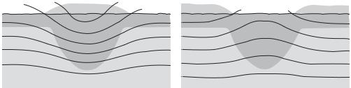
244 FROSTMARKS/SNOWMARKS
–1°
0°C
+1° 0°C
+2° +1°
+3° +2°
+4° +3°
+4°
Figure 17 frostmarks Frost and snowmarks over buried features may show either negatively (left) or positively (right). At first, a buried feature with fill of raised organic content may remain warmer than its surroundings (left), but after a prolonged cold spell it may become colder (right). Source: O. Braasch: Luftbildarchäologie in Süddeutschland (Stuttgart, 1983).
or negative – of frost or snow over buried features, caused by their different heat-retaining properties. The same feature may produce either positive or negative marks, as the cause is the variation in the coefficient of heating between the buried feature and the surrounding subsoil. These marks have been a key source of information in much Central European flying in recent years (Braasch 1983). In addition, the visibility of low earthworks may be increased in conditions of frost and snow (see AERIAL ARCHAEOLOGY for general discussion).
O. Braasch: Luftbildarchäologie in Süddeutschland
(Stuttgart, 1983).
FG
Fufeng (Fu-feng) see WESTERN CHOU
Fu-hao see AN-YANG
Fukui Cave Site in Nagasaki prefecture, Japan, which has yielded sherds from the oldest dated ceramic vessels in the world. Radiocarbon-dated to 12,700 BP, the earliest sherds were thin-walled and decorated with thin appliqué strips of clay and were associated with typical Late Palaeolithic obsidian microliths, indicating continuity between the nonceramic Palaeolithic and the Jomon period (see
JAPAN 1–2).
Y. Kamaki and C. Serizawa: ‘Nagasaki-ken Fukui doketsu’ [Fukui Cave, Nagasakai Prefecture], Nihon no Doketsu Iseki [Cave sites in Japan] (Tokyo, 1967); C.M. Aikens and T. Higuchi: The prehistory of Japan (London, 1982), 99–104.
SK
Funan The earliest known state in Southeast Asia, which dates to AD 100–550 and was centred on the flat and low-lying land west of the Bassac River
in southern Vietnam. Some scholars prefer the Sanskrit term MANDALA, meaning a circle, rather than the word ‘state’ when describing Funan; the former brings with it the notion of a polity with fluid boundaries ringed by like entities, and centred on the overlord and his ability to attract and retain followers. Inscriptions reveal the adoption of Sanskrit names for rulers, while archaeology has confirmed the presence of moated cities such as the coastal settlement of OC EO, substantial brick buildings and intensive trade contacts with both India and the Mekong hinterland.
It seems likely that the capital of the Funan polity was the site of Angkor Borei, 70 km south of Phnom Pehn. Two Chinese visitors in the mid-3rd century AD described the area as Funan, noting walled settlements, palaces, taxation and a writing system (evidently of Indian origin). Angkor Borei is a nodal centre within the canal system, lying at the northern end of a 90 km canal linking it to OC EO. Coinage of Roman and Iranian origin shows that the Funan region was itself a nodal point in a trade route connecting the Roman and Chinese empires. Centres were linked by a network of canals, which would have been used in the moving of goods and as a means of draining the flat lowlands of floodwater. By the middle of the 6th century AD, the centre of political power had moved to the middle Mekong, with the establishment of the mandalas of the
ZHENLA CULTURE (AD 550–800).
C. Jacques: ‘ “Funan”, “Zhenla”: the reality concealed by these Chinese views of Indochina’, Early South East Asia, ed. R.B. Smith and W. Watson (Oxford, 1979), 371–9; P. Wheatley: Nagara and Commandery (Chicago, 1983).
CH
functionalist argument, functionalism In its widest sense, an approach to describing and