

3.1.2 Read the text once more and fill in the chart with the necessary information. Then label the diagram and give an explanation what each item means.
THE EARTH
Part |
Division |
Volume |
Composition |
Depth |
Other terms |
|
|
|
|
|
|
3.1.3. Using this diagram, answer the following questions as briefly as possible. Use the information from the text «The Earth» and describe the diagram.( Paul Nixon & Alferdo Bezzi “English for Geologists”)
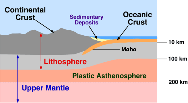
1. Does the Moho separate the mantle and the crust?
2. Is the lithosphere topped by a relatively lightweight crust?
3. Does the crust vary in thickness?
4. Where is the crust thinnest?
5. Does the lithosphere include the uppermost part of the mantle and crust?
6. Is the asthenosphere rigid?
3.2 Detailed reading - Earth’s size and shape
Read the text and then complete the task. Fill in the gaps.
Instruments including artificial satellites have helped scientists work out the Earth’s size, shape and other features. We know ours is one of the smallest, lightest planets of the solar system. Four others far exceed its mass and volume. But no planet has a greater density (5.5 times that of water).
Careful measurements prove the ball-like Earth is not in fact a sphere. It measures 24,901.5 mi. (40 074 km) around the equator, but only 24,859.7 mi. (40 008 km) around the poles. So our planet bugles slightly at the equator and is slightly flattened at the poles.
Centrifugal force created by the Earth’s spin produced this shape, an oblate spheroid. Even that description oversimplifies, for the Earth is very slightly pear-shaped.
Scientists accordingly use the term “geoid“ (earth shaped) to describe the Earth’s hypothetical, mean-sea-level surface-ignoring wrinkles formed by mountain chains and ocean floors. Geoid measurement involves taking sea-level gravity readings by gravimeter and studying “kinks” in orbits of artificial satellites. Both reveal so-called gravity anomalies reflecting local differences in mass in the Earth’s crust and mantle. Such differences account for vast but slight dips and bumps in the geoid’s surface.
Gravity anomalies also reinforce the theory of isostasy – a state of balance in the Earth’s crust where continents of light material float on a denser substance into which deep continental “roots” project like the underwater mass of floating icebergs.
(Lambert “The Field Guide to Geology” 1988, Cambridge University Press)
Fill in the gaps using the words under the line
Artificial satellites have helped scientists to work out the Earth’s (1)__________ and shape. The Earth is the (2)__________ planet of the solar system. But it has a greater (3)__________ than all the other planets. Measurements prove that the Earth is not a (4)_________. Earth’s (5)_________ produced this shape- oblate spheroid. Scientists use the term (6)_________ to describe the Earth’s surface. It involves taking sea-level (7)_________ and studying (8) __________ in orbits. These reveal so-called (9)_________. They reflect the differences in the Earth’s (10)________ and mantle. Gravity anomalies reinforce the theory of (11)________. This term means the state of balance in the Earth’s (12)____________.
size density gravity lightest spin
kinks sphere geoid anomalies crust × (2)