Change the viewing mode between 360˚ and 120˚:
1)Select the Stormscope Page.
2)Press the VIEW Softkey. The 360 andARC Softkeys are displayed. Press the 360 Softkey to display a 360˚ viewing area or press the ARC Softkey to display a 120˚ viewing area.
Press the CLEAR Softkey to remove all Stormscope lightning data from the display.
10.3 XM WEATHER (SERVICE OPTIONAL)
WARNING: XM Weather is not intended to be used for hazardous weather penetration. Weather information provided by XM Radio Service is approved only for weather avoidance, not penetration.
1)From the Navigation Map Page, press the MAP Softkey.
2)Press the NEXRAD or XM LTNG Softkey to display the desired weather. Press the applicable softkey again to remove weather data from the Navigation Map Page.
Figure 10-7 Navigation Map Page Displaying NEXRAD Weather
SECTION 10 – HAZARD
AVOIDANCE
NOTE:WeatherisnotdisplayedontheNavigation Map Page at zoom levels less than 10 nm.
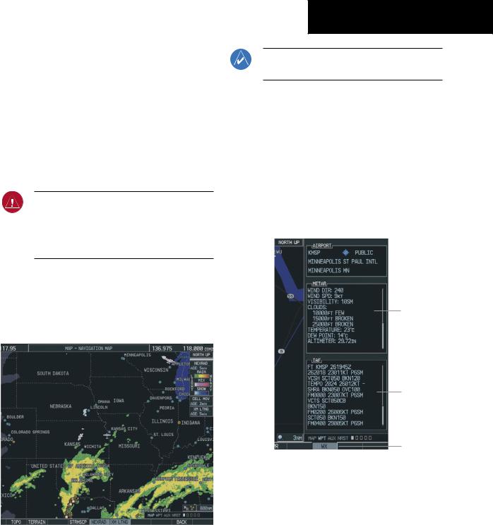
Displaying METAR and TAF information on the Airport Information Page
1)Turn the large FMS Knob to select the WPT Page Group.
2)Turn the small FMS Knob to select the Airport Information Page.
3)Press the WX Softkey to display METAR and TAF text (METAR andTAF information is updated every 12 minutes).
METAR
Text
TAF
Text
WX
Softkey
Figure 10-8 METAR and TAF Text Displayed on the
Airport (Weather) Information Page
190-00384-08 Rev.A |
Garmin G1000 Cockpit Reference Guide for the Cessna Nav III |
10-3 |
SECTION 10 – HAZARD
AVOIDANCE
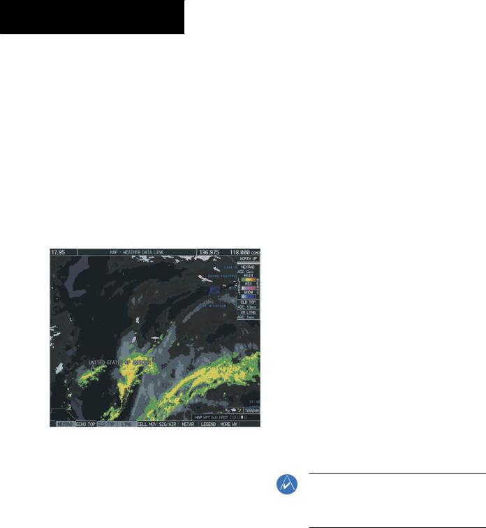
Displaying Weather on the Weather Data Link Page
Select the Weather Data Link Page:
1)Turn the large FMS Knob to select the Map Page Group.
2)Turn the small FMS Knob to select the fourth rectangular page icon.
3)Press the available softkeys to select the desired XM weather product.
4)Press the LEGEND Softkey to view the legends for the selected products. If necessary,turn either FMS Knob to scroll through the list. Press the small FMS Knob or the ENT Key to return to the map.
Figure 10-9 Weather Data Link Page
NEXRAD – Press the NEXRAD Softkey to show NEXRAD weather and radar coverage information. Areas where radar coverage is not available are shown in grayish-purple. The display is updated every five minutes.
NEXRAD Limitations
Certain limitations exist regarding the NEXRAD radar displays. Some, but not all, are listed here:
•NEXRAD base reflectivity does not provide sufficient information to determine cloud layers or precipitation characteristics (hail vs. rain, etc).
•An individual NEXRAD site cannot depict high altitude storms at close ranges, and has no information about storms directly over the site.
•TheresolutionofdisplayedNEXRADdatais4square kilometers. Therefore, when zoomed in on the display, each square block is 2 kilometers on each side. The intensity level reflected by the square is the highest level sampled within the square area.
ECHO TOP – Press the ECHO TOP Softkey to show the location, elevation, and direction the highest radar echo. This may not indicate the top of a storm or clouds, only the highest radar return echo. ECHO TOPS cannot be displayed along with NEXRAD and CLOUD TOPS. When ECHO TOPSisactivated,NEXRADandCLOUDTOPSare removed. Refer to the Legend for a description of the ECHO TOPS coding. The display is updated every 7.5 minutes.
CLD TOP – Press the CLD TOP Softkey to show the cloudtopaltitudedeterminedfromsatelliteimagery. The display is updated every 15 minutes.
LTNG–PressingtheLTNGSoftkeyshowsthelocation ofcloud-to-groundlightningstrikes. Thedisplayis updated every five minutes.
NOTE:Strikesdepictedrepresentcloudtoground strikes within a 2 kilometer radius of the actual strike location. Therefore, the exact location of the strike is not displayed.
10-4 |
Garmin G1000 Cockpit Reference Guide for the Cessna Nav III |
190-00384-08 Rev.A |

CELL MOV – Pressing the CELL MOV Softkey showsstorm cellmovementbydisplaying anarrow pointing in the direction of predicted movement. The display is updated every 12 minutes.
SIG/AIR – Pressing the SIG/AIR Softkey shows SIGMET and AIRMET information. The display is updated every 12 minutes.
METAR – Press the METAR Softkey to graphically display METARs. METARS are shown as colored flags at airports providing METAR reports. The display is updated every 12 minutes.
MORE WX – Press the MORE WX Softkey to display the following group of softkeys for additional weather control:
SFC–PressingtheSFCSoftkeyforSurfaceAnalysis shows current or forecast conditions. Forecasts are available for intervals of Current, 12, 24, 36, and 48 hours. Press the softkey corresponding to the desired forecast. The closest city forecast information is displayed in the legend. The display is updated every 12 minutes.
FRZ LVL – Press the FRZ LVL Softkey to display contour lines for freezing levels. The display is updated every 12 minutes.
WIND – Press the WIND Softkey to show wind speed and direction at a selected altitude from the ground up to 42,000 feet in 3,000 foot increments. After pressing the WIND Softkey, press the softkey corresponding to the desired windsaloftaltitude. Thedisplayisupdatedevery 12 minutes.
COUNTY–PressingtheCOUNTYSoftkeyprovides specificpublicawarenessandprotectionweather warnings for Tornado, Severe Thunderstorm, and Flood conditions provided by the National Weather Service (NWS). The display is updated every 5 minutes.
SECTION 10 – HAZARD
AVOIDANCE
CYCLONE–PressingtheCYCLONESoftkeyshows the current location of cyclones (hurricanes and tropical storms) and their projected track at various time intervals. The update rate is every 12 minutes.
Map Panning Information – Weather Data Link
Page
1)Push in the Joystick to display the panning arrow.
2)Move the Joystick to place the panning arrow on AIRMETs, TFRs, METARs, or SIGMETs. Press the ENT Key to display pertinent information for the selected product.
Note that pressing the ENT Key when panning over anAIRMET or a SIGMET displays an information box that displays the text of the report. Panning over an airport with METAR information does not display more information but allows the user to press the ENT Key and select thatAirport’s Information Page to display the text of the report. Pressing the ENT Key when panning over a TFR displays TFR specific information.
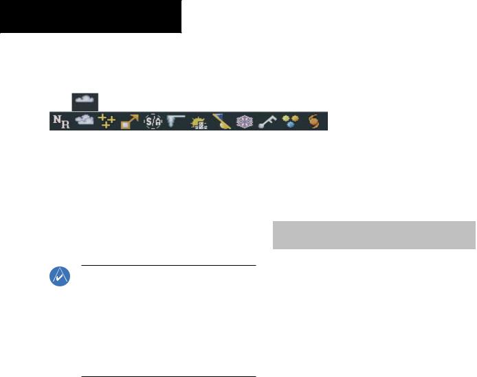
Weather Products & Symbols
Figure 10-10 depicts the symbol for each weather product (read from left to right). When aweather product is active, the product symbol is displayed in the lower right of the screen.
•NEXRAD
•Cloud Top/Echo Top
•XM Lightning
•Cell Movement
•SIGMETs/AIRMETs
•METARs
•City Forecast
•Surface Analysis
•Freezing Levels
190-00384-08 Rev.A |
Garmin G1000 Cockpit Reference Guide for the Cessna Nav III |
10-5 |