

SECTION 7: NAVIGATION
The majority of the following discussions pertain to the Multi Function Display. In discussions pertaining to the PFD, the controls are located on the PFD.
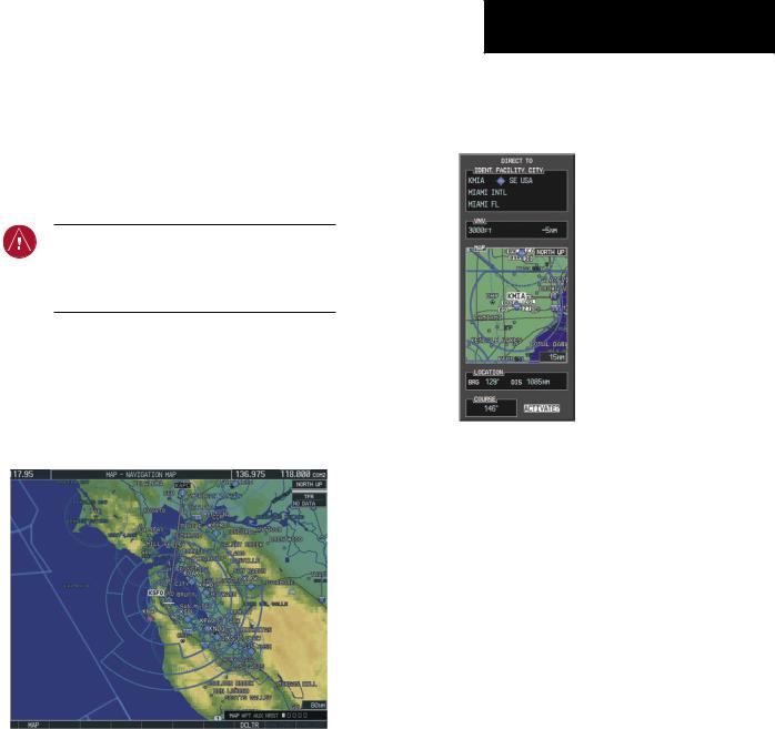
7.1NAVIGATION MAP PAGE
WARNING: The map display should only be used for situational awareness. Any map display indication should be compared with approved navigation sources.
Select the MAP Page Group
1)Turn the large FMS Knob until‘MAP’ is highlighted in the page group box in the lower right of the MFD display.
2)Turn the small FMS Knob to select the first MAP page (indicated by a solid rectangular icon).
Figure 7-1 Navigation Map Page (Enroute)
SECTION 7 – NAVIGATION
7.2DIRECT-TO NAVIGATION
Direct-to Navigation from the MFD
Identifier |
|
|
|
|
|
|
|
|
|
|
|
|
Geographic |
|||||||
|
|
|
|
|
||||||||||||||||
Facility Name |
|
|
|
|
|
|
|
|
|
|
|
|
|
|
|
|
Region |
|||
|
|
|
|
|
|
|
|
|
|
|
|
|
|
|
|
|||||
|
|
|
|
|
|
|
|
|
|
|
|
|
|
|
|
|
|
|||
|
|
|
|
|
|
|
|
|
|
|
|
|
|
|
|
|
||||
City |
|
|
|
|
|
|
|
|
|
VNAV Target Altitude |
||||||||||
|
|
|
||||||||||||||||||
VNAV |
|
|
|
|
|
|
|
|
|
|
|
|
|
|
Offset Before Selected |
|||||
|
|
|
|
|
|
|
|
|
|
|
|
|
|
|
Direct-to |
|||||
|
|
|
|
|
|
|
|
|
|
|
|
|
|
|||||||
Target Altitude |
|
|
|
|
|
|
|
|
|
|
Map Orientation |
|||||||||
Map of the |
|
|
|
|
|
|
|
|
|
|
||||||||||
|
|
|
|
|
|
|
|
|
|
|
|
|||||||||
Selected |
|
|
|
|
|
|
|
|
|
|
|
|
|
|
||||||
|
|
|
|
|
|
|
|
|
|
|
|
|
|
|||||||
Waypoint |
|
|
|
|
|
|
|
|
|
|
|
|
||||||||
Bearing |
|
|
|
|
|
|
|
|
|
|
|
Map Range |
||||||||
|
|
|
|
|
|
|
|
|
|
|
||||||||||
|
|
|
|
|
|
|
|
|
Distance |
|||||||||||
|
|
|
|
|
|
|
|
|
|
|
||||||||||
Direct-to |
|
|
|
|
|
|
|
|
|
|
Activate Field |
|||||||||
Course |
|
|
|
|
|
|
|
|
|
|||||||||||
|
|
|
|
|
|
|
|
|
|
|
|
|||||||||
Figure 7-2 MFD Direct-to Window
Enter a Direct-to Destination
1)Press the Direct-to ( ) Key.
2)Enter the destination waypoint identifier.
3)Press the ENT Key to confirm the identifier. The ‘Activate?’ field is highlighted.
4)If no altitude constraint or course is desired, press the ENT Key to activate. To enter an altitude constraint, proceed to step 5.
5)Turn the large FMS Knob to place the cursor over the ‘VNAV’ altitude field.
6)Enter the desired altitude.
7)Press the ENT Key. The option to select ‘MSL’ or ‘AGL’ is now displayed.
8)Turn the small FMS Knob to select ‘MSL’ or ‘AGL’.
190-00384-08 Rev.A |
Garmin G1000 Cockpit Reference Guide for the Cessna Nav III |
7-1 |
SECTION 7 – NAVIGATION
9)Press the ENT Key. The cursor is placed in the ‘VNV’ offset distance field.
10)Enter the desired target altitude offset from the selected Direct-to.
11)Press the ENTKey to highlight‘Activate?’ or turn the large FMS Knob to highlight the ‘COURSE’ field.
12)Enter the desired course to the waypoint.
13)Press the ENT Key to highlight ‘ACTIVATE?’.
14)Press the ENT Key again to activate the Direct-to.
Select a Direct-to Destination to a Flight Plan Waypoint
1)While navigating an active flight plan, press the
Direct-to ( ) Key.
2)Turn the small FMS Knob to the left to display a list of flight plan waypoints as shown in Figure 7-3.
Figure 7-3 Flight Plan Waypoint List (MFD)
3)Turn the large FMS Knob to select the desired waypoint.
4)Press the ENT Key. The cursor is now displayed on ‘ACTIVATE?’.
5)Press the ENT Key again to activate a Direct-to.
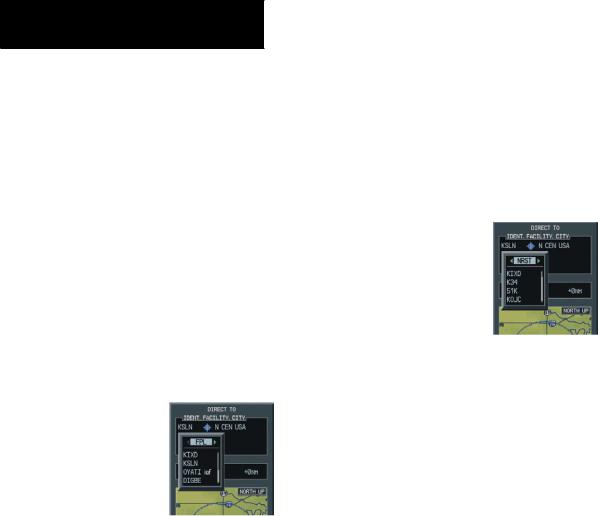
Select a Direct-to Destination to a Nearest Airport
1)Press the Direct-to ( ) Key.
2)Turn the small FMS Knob to the left. Initially, a flight plan waypoint list is displayed as in Figure 7-3. The list is populated only when navigating a flight plan.
Figure 7-4 Nearest Airport List (MFD)
3)Turn the small FMS Knob to the right to display the ‘NRST’ airports to the aircraft’s current position as shown in Figure 7-4.
4)Turn the large FMS Knob to select the desired airport.
5)Press the ENT Key. The cursor is now displayed on ‘ACTIVATE?’.
6)Press the ENT Key again to activate a Direct-to.
Select a Direct-to Destination to a Recently Entered Identifier
1)Press the Direct-to ( ) Key.
2)Turn the small FMS Knob to the left. Initially, a flight plan waypoint list is displayed as in Figure 7-3. The list is populated only when navigating a flight plan.
7-2 |
Garmin G1000 Cockpit Reference Guide for the Cessna Nav III |
190-00384-08 Rev.A |

SECTION 7 – NAVIGATION
Figure 7-5 Recently Entered Waypoints List (MFD)
3)Turn the small FMS Knob to the right to display the ‘RECENT’ waypoints as shown in Figure 7-5.
4)Turn the large FMS Knob to select the desired airport.
5)Press the ENT Key. The cursor is now displayed on ‘ACTIVATE?’.
6)Press ENT again to activate a Direct-to.
Re-center the CDI to the Destination Waypoint
Press the Direct-to ( ) Key, followed by pressing the ENT Key twice. If a missed approach point (MAP) is the current destination,the approach is canceled.
Manually Define the Active Direct-to
1)Press the Direct-to ( ) Key.
2)Turn the large FMS Knob to highlight the ‘VNAV’ altitude field.
3)Enter the desired altitude.
4)Press the ENT Key. The option to select ‘MSL’ or ‘AGL’ is now displayed.
5)Turn the small FMS Knob to select ‘MSL’ or ‘AGL’.
6)Press the ENT Key. The cursor now highlights the VNAV offset field.
7)Enter the desired offset distance.
8)Press the ENT Key.
9)Turn the large FMS Knob to place the cursor in the ‘COURSE’ field.
10)Enter the desired course.
11)Press the ENT Key. The cursor now highlights ‘ACTIVATE?’.
12)Press the ENT Key again to begin navigation using the selected destination, altitude constraint, and course.
Canceling Direct-to Navigation
1)Press the Direct-to ( ) Key.
2)Press the MENU Key to display the Direct-to options menu.
3)With ‘Cancel Direct-To NAV’ highlighted, press the ENT Key. If a flight plan is still active, the G1000 resumes navigating the flight plan along the closest leg.
Figure 7-6 |
Canceling Direct-to Navigation |
||||||||||||||
Direct-to Navigation from the PFD |
|||||||||||||||
|
|
|
|
|
|
|
|
|
|
WPT Symbol |
|||||
Identifier |
|
|
|
|
|
|
|
|
|
WPT Location |
|||||
|
|
|
|
|
|
|
|
|
|||||||
|
|
|
|
|
|
|
|
|
|||||||
|
|
|
|
|
|
|
|||||||||
Facility Name |
|
|
|
|
|
|
|
|
|
|
|
|
|
||
|
|
|
|
|
|
|
|
|
|
|
|
||||
VNAV Target Altitude |
|
|
|
|
|
|
Offset Distance |
||||||||
|
|
|
|
|
|||||||||||
Bearing to WPT |
|
|
|
|
|
|
|
|
|
|
Distance from WPT |
||||
|
|
|
|
|
|
|
|
||||||||
Course to Selected WPT |
|
|
|
|
|
|
|
|
|
|
|
|
|
||
|
|
|
|
|
|
|
|
|
|
|
|
||||
Figure 7-7 PFD Direct-to Window
190-00384-08 Rev.A |
Garmin G1000 Cockpit Reference Guide for the Cessna Nav III |
7-3 |

SECTION 7 – NAVIGATION
Enter a Direct-to Destination
1)Press the Direct-to Key ( ).
).
2)Turn the large FMS Knob to place the cursor in the desired selection field.
3)Turn the small FMS Knob to begin selecting the desired identifier, location, etc.
4)Press the ENT Key.
5)The cursor is now flashing on ‘ACTIVATE?’. If no altitude constraint or course is desired, press the ENT Key to activate. To enter an altitude constraint, proceed to step 6.
6)Turn the large FMS Knob to place the cursor over the ‘VNAV’ altitude field.
7)Turn the small FMS Knob to enter the desiredVNAV altitude.
8)Press the ENT Key. The option to select ‘MSL’ or ‘AGL’ is now displayed.
9)Turn the small FMS Knob to select ‘MSL’ or ‘AGL’.
10)Press the ENT Key. The cursor is placed in the ‘VNAV’ offset distance field.
11)Turn the small FMS Knob to enter the desired target altitude offset from the selected Direct-to.
12)Press the ENTKey to highlight‘Activate?’ or turn the large FMS Knob to highlight the ‘COURSE’ field.
13)Turn the small FMSKnob to enter the desired course to the waypoint.
14)Press the ENT Key to highlight ‘ACTIVATE?’.
15)Press the ENT Key again to activate the Direct-to.
Select a Direct-to Destination to a Flight Plan Waypoint
1)While navigating an active flight plan, press the
Direct-to ( ) Key.
2)Turn the small FMS Knob to the left to display a list of flight plan waypoints as shown in Figure 7-8.
Figure 7-8 Flight Plan Waypoint List (PFD)
3)Turn the large FMS Knob to select the desired waypoint.
4)Press the ENT Key. The cursor is now displayed on ‘ACTIVATE?’.
5)Press the ENT Key again to activate a Direct-to.
Select a Direct-to Destination to a Nearest Airport
1)Press the Direct-to ( ) Key.
2)Turn the small FMS Knob to the left. Initially, a flight plan waypoint list is displayed as in Figure 7-8. The list is only populated when navigating a flight plan.
Figure 7-9 Nearest Airport List (PFD)
3)Turn the small FMS Knob to the right to display the ‘NRST’ airports to the aircraft’s current position as shown in Figure 7-9.
7-4 |
Garmin G1000 Cockpit Reference Guide for the Cessna Nav III |
190-00384-08 Rev.A |