

ppl_03_e2
.pdfID: 3658
Customer: Oleg Ostapenko E-mail: ostapenko2002@yahoo.com Customer: Oleg Ostapenko E-mail: ostapenko2002@yahoo.com
CHAPTER 3: DIRECTION
THE DIRECTION INDICATOR.
The indication errors to which the magnetic compass is susceptible, caused by the presence of extraneous magnetic fields, and by accelerations and turning manoeuvres, make the magnetic compass difficult to interpret exactly in any flight condition other than straight and level, in the climb, or descent. Consequently, many pilots prefer to set and hold headings with reference to the direction indicator (sometimes also referred to as the directional gyro or heading indicator).
Being driven by a gyroscope and relying on the principles of gyroscopic rigidity in space, the direction indicator (DI) is free from the errors suffered by the magnetic compass, and is much easier and more accurate to use, especially for executing precise turns onto desired headings.
The construction, principle of operation, and errors of the DI are covered in detail in
Chapter 15 of the ‘Aeroplanes’ volume of this series.
In most modern aircraft, heading information is displayed by the DI in the form of the plan view of an aeroplane, whose nose indicates the direction in which the aircraft is heading, set against a rotating disc featuring a compass card graduated in degrees. (See Figure 3.19.) The aircraft image is stationary and, as the aircraft turns, the gyroscopically stabilised mechanism of the DI causes the compass card to rotate, with respect to the aircraft image, to give an accurate indication of aircraft heading.
Figure 3.19 A Direction Indicator.
As the DI possesses no north-seeking property or mechanism, the heading indicated by the DI must be synchronised with the magnetic compass. Headings read from the DI are, thus, magnetic headings.
Errors of the Direction Indicator (DI).
The gyroscope inside the DI is spun either electrically, or by air from a vacuum pump. Because the Earth rotates on its axis at approximately 15° per hour, while the DI’s gyroscope remains fixed in space, and because of small imperfections in the gyroscope, itself, the DI will drift or wander, over time, causing errors in its indications.
Consequently, the DI must be periodically resynchronised with the magnetic compass, usually about every 10 to 15 minutes, and after manoeuvres such as steep turns.
During resynchronisation, the aeroplane must be in straight and level, unaccelerated flight, or else the pilot will not obtain an accurate reading from the compass. Resynchronising the compass normally cages the DI gyro too, so this must be done in straight and level, unaccelerated flight.
47

Order: 6026
Customer: Oleg Ostapenko E-mail: ostapenko2002@yahoo.com
Customer: Oleg Ostapenko E-mail: ostapenko2002@yahoo.com
CHAPTER 3: DIRECTION
The DI must be
resynchronised against the magnetic
compass every 15 minutes. The aircraft must be in level, steady, unaccelerated flight during resynchronisation.
Pilot Serviceability Checks for the Direction Indicator.
Before take-off, but after engine start, check that the vacuum gauge is indicating sufficient suction for the gyroscope rotor to operate at the correct rotational speed. As soon as practicable, set the Direction Indicator heading to the compass magnetic heading. While taxying, check that the Direction Indicator shows an increasing reading when the aircraft is turned to the right, and a decreasing reading when the aircraft is turned to the left.
Synchronising Direction Indicator and Magnetic Compass.
Having learned about the indication errors to which the magnetic compass is susceptible, you are now in a position to appreciate why the aircraft must be flown at a constant speed, with wings level, whenever the Direction Indicator is to be synchronised with the Magnetic Compass. As we have mentioned, resynchronisation should be carried out by the pilot, every 10 to 15 minutes or so, normally as part of the FREDA checks.
THE FREDA CHECK.
Fuel |
- |
contents sufficient and correct tank selected. |
Radio |
- |
correct frequency selected, and next frequency pre-selected, |
|
|
if appropriate. |
Engine |
- |
temperatures and pressures within limits. Mixture correctly |
|
|
set. Carburettor heat, as appropriate. |
DI |
- |
synchronised with compass. |
Altimeter |
- |
correct altimeter sub-scale setting selected. |
48

ID: 3658
Customer: Oleg Ostapenko E-mail: ostapenko2002@yahoo.com
Customer: Oleg Ostapenko E-mail: ostapenko2002@yahoo.com
CHAPTER 3: DIRECTION QUESTIONS
Representative PPL - type questions to test your theoretical knowledge of Direction.
1.The angle between the horizontal and vertical components of the Earth’s magnetic field is known as:
a.Angle of Inclination
b.Magnetic angle
c.Angle of Dip
d.Angle of Incidence
2.Magnetic Variation is the angle between:
a.True North and the nearest line of Longitude
b.True North and Magnetic North
c.Magnetic North and the aircraft’s magnetic heading
d.Magnetic North and the aircraft’s true heading
3.Which of these statements is correct?
a.Variation best - magnetic west: variation least - magnetic east
b.Variation west - magnetic best: variation east - magnetic least
c.Variation west - magnetic least: variation east - magnetic best
d.Variation least - magnetic west: variation best - magnetic east
4.An Isogonal is a line joining points of:
a.Equal magnetic deviation
b.Zero magnetic variation
c.Equal magnetic variation
d.Zero magnetic deviation
5.An Agonic line joins points of:
a.Equal magnetic deviation
b.Zero magnetic deviation
c Equal magnetic variation
d.Zero magnetic variation
6.Compass Deviation is the angle between:
a.True North and the heading indicated by the compass needle
b.Magnetic heading and the heading indicated by the compass needle
c.The heading indicated by the compass needle and the Earth’s magnetic field
d.The indications of the aircraft’s main and standby compasses
7.Which of these statements is correct?
a.Deviation west – compass best: deviation east – compass least
b.Deviation west – compass least: deviation east – compass best
c.Deviation west – true heading best: deviation east – true heading least
49

Order: 6026
Customer: Oleg Ostapenko E-mail: ostapenko2002@yahoo.com
Customer: Oleg Ostapenko E-mail: ostapenko2002@yahoo.com
CHAPTER 3: DIRECTION QUESTIONS
d.Deviation best– compass west: deviation least – compass east
8.With a calculated heading of 246º True, a local magnetic variation of 5ºW and a compass deviation of 1ºE, the compass heading is:
a.252º
b.242º
c.241º
d.250º
9.With a compass heading of 110º, a compass deviation of -3º and magnetic variation of 6ºW, what is the True heading?
a.107º
b.113º
c.101º
d.119º
10.Which of the following statements is not correct?
a.Turning errors are maximum when turning through North and South
b.Acceleration errors are maximum on East/West headings
c.Turning errors are maximum when turning through East and West
d.Acceleration errors are minimum on North/South headings
11.Which of the following statements is correct?
a.During a turn through the pole which is physically nearer the aircraft the compass will be sluggish. It is therefore necessary to roll out late on the indication given by the direct reading compass
b.During a turn through the pole which is physically further from the aircraft the compass will be sluggish. It is therefore necessary to roll out early on the indication given by the direct reading compass
c.During a turn through the pole which is physically further from the aircraft the compass will be lively. It is therefore necessary to roll out early on the indication given by the direct reading compass
d.During a turn through the pole which is physically nearer the aircraft the compass will be sluggish. It is therefore necessary to roll out early on the indication given by the direct reading compass
12.A direct-reading compass in an aircraft executing a level turn, at a constant rate, in the Northern Hemisphere, will be subject to the largest turning error as the aircraft turns through:
a.East and West
b.North and South
c.Northeast and Northwest
d.Southeast and Southwest
50

ID: 3658
Customer: Oleg Ostapenko E-mail: ostapenko2002@yahoo.com
Customer: Oleg Ostapenko E-mail: ostapenko2002@yahoo.com
CHAPTER 3: DIRECTION QUESTIONS
13.When turning anti-clockwise onto a southerly heading in the Northern Hemisphere the turn should be stopped:
a.Before the required heading is indicated
b.When the compass slows down
c.After the required heading is indicated
d.Exactly on the required heading is indicated
Question |
1 |
2 |
3 |
4 |
5 |
6 |
7 |
8 |
9 |
10 |
11 |
|
Answer |
|
|
|
|
|
|
|
|
|
|
|
|
|
|
|
|
|
|
|
|
|
|
|
|
|
Question |
12 |
13 |
|
|
|
|
|
|
|
|
|
|
Answer |
|
|
|
|
|
|
|
|
|
|
|
|
The answers to these questions can be found at the end of this book.
51
Customer: Oleg Ostapenko E-mail: ostapenko2002@yahoo.com
52
Customer: Oleg Ostapenko E-mail: ostapenko2002@yahoo.com
CHAPTER 4
SPEED, DISTANCE AND TIME
53

Order: 6026
Customer: Oleg Ostapenko E-mail: ostapenko2002@yahoo.com
Customer: Oleg Ostapenko E-mail: ostapenko2002@yahoo.com
CHAPTER 4: SPEED, DISTANCE AND TIME
54
ID: 3658
Customer: Oleg Ostapenko E-mail: ostapenko2002@yahoo.com
Customer: Oleg Ostapenko E-mail: ostapenko2002@yahoo.com
CHAPTER 4: SPEED, DISTANCE AND TIME
INTRODUCTION.
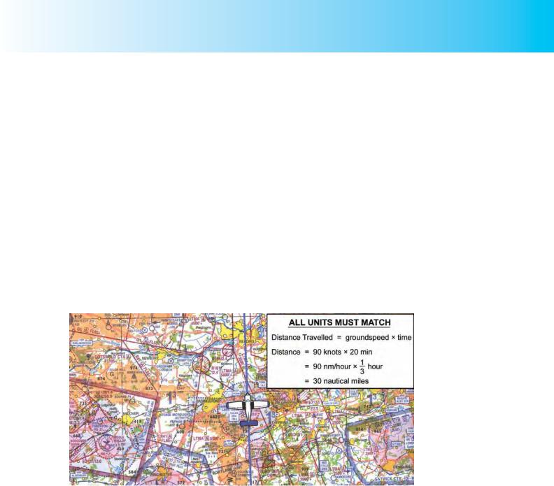
The basic method of visual navigation, which is most commonly called dead reckoning, involves the pilot determining his present position based on an accurate history (kept in the flight log) of heading, airspeed and time.
As you will learn in a later chapter, by taking into account the direction and speed of the wind (i.e. the wind velocity), the above information can be converted into groundspeed and distance travelled along a desired or observed track, and the changing position of the aircraft may be monitored relative to its starting point.
Computations involving speed, distance and time are, thus, central to dead reckoning navigation and the pilot-navigator needs to be confident that he can make such computations accurately.
One of the prime considerations in ensuring the accuracy of navigation calculations is that the units used for speed and distance are the correct ones. Speed is simply the expression of distance covered in a given amount of time. But for calculations to be accurate, the units of speed, distance and time must match one another.
Figure 4.1 The basic method of visual navigation involves the pilot determining his present position based on an accurate history of heading, speed and time. All units must match one another.
SPEED, DISTANCE AND TIME CALCULATIONS.
Mathematically, it is straight forward to prove that:
speed = |
distance |
; |
distance = speed × time ; |
time = |
distance |
time |
|
speed |
For the pilot navigator whose primary concern is to measure progress along a desired track, the speed in question is groundspeed. The above equations thus become:
|
distance = groundspeed × time; |
|
|
|||
groundspeed = |
distance |
; |
time = |
|
distance |
|
time |
|
groundspeed |
|
|||
55
Order: 6026
Customer: Oleg Ostapenko E-mail: ostapenko2002@yahoo.com
Customer: Oleg Ostapenko E-mail: ostapenko2002@yahoo.com
CHAPTER 4: SPEED, DISTANCE AND TIME
The pilot-navigator would be wise to commit these simple equations to memory and, when he uses the equations in navigation calculations, he must take great care to make sure that the units match. He should find, however, that by using the flight navigation computer (see Chapter 11), speed, distance, time calculations are not difficult.
A student who wishes to learn more about the underlying Physics of speed, distance and time calculations, as well as about the basic science which explains many of the phenomena of flight, may wish to refer to OAAmedia’s CD-ROM, ‘Essential Physics
2’ - Motion, Forces, Energy and Astronomy.
groundspeed = distance time
OAAmedia’s ‘Essential Physics 2’ - Motion, Forces, Energy and Astronomy.
SPEED.
We will begin with the equation: |
groundspeed = |
distance |
|
time |
|||
|
|
A certain number of miles covered by an aircraft, along track, in a known number of hours, will enable you to determine groundspeed in miles per hour. For instance, from the above equation, a journey of 200 miles covered in 4 hours gives a groundspeed of 50 miles per hour.
|
|
|
50 |
|
|
groundspeed = |
distance |
= |
200 miles |
= 50 miles per hour |
|
4 hours |
|||||
|
time |
|
|
||
|
|
|
1 |
|
Note, however, that if the time is given in minutes, groundspeed will be in miles per minute and will need converting into miles per hour. Thus, if 40 miles is covered in 20 minutes, the equation gives us the following information:
|
|
|
2 |
|
||
groundspeed = |
distance |
= |
|
40 miles |
= 2 miles per minute |
|
20 minutes |
||||||
|
time |
|
|
|||
|
|
|
1 |
|
||
In order to convert to miles per hour, we must multiply by 60 (there being 60 minutes
in an hour). |
distance |
|
40 |
|
40 |
|
|||
groundspeed = |
= |
miles per minute = |
× 60 miles per hour |
||||||
time |
20 |
20 |
|||||||
|
120 |
|
|
|
|
|
|
|
|
= |
240 |
= 120 miles per hour |
|
|
|
|
|||
20 |
|
|
|
|
|||||
|
1 |
|
|
|
|
|
|
|
|
56