

ppl_03_e2
.pdfID: 3658
Customer: Oleg Ostapenko E-mail: ostapenko2002@yahoo.com
Customer: Oleg Ostapenko E-mail: ostapenko2002@yahoo.com
CHAPTER 9: PRINCIPLES OF DEAD RECKONING VISUAL AIR NAVIGATION
When updating estimated elapsed times and estimated times of arrival, it is convenient to do so at checkpoints which lie halfway or a third, and two thirds, of the way along track.
If you are, say, one minute behind time at the half-track point, you will complete the leg two minutes behind time.
If you are two minutes early at a checkpoint, one third of the way along track, you will be four minutes early at a checkpoint two thirds of the way along track and 6 minutes early at your destination or turning point.
So, fly accurately, consult your chart at appropriate times, and maintain a good look out for other traffic.
Above all, you should be aware that, in visual navigation, most of the navigation is donebeforeyouevengetairborne. Ifyoucarryoutyourflightplanningthoroughly,and study your route closely, the navigational task in the air should be straightforward.
147

Order: 6026
Customer: Oleg Ostapenko E-mail: ostapenko2002@yahoo.com
Customer: Oleg Ostapenko E-mail: ostapenko2002@yahoo.com
CHAPTER 9: PRINCIPLES OF DEAD RECKONING VISUAL AIR NAVIGATION QUESTIONS
Representative PPL - type questions to test your theoretical knowledge of Principles of Dead Reckoning Visual Air Navigation.
1.You plan to fly a cross-country flight at 2 500 feet at a true airspeed of 90 knots. The forecast wind is 165°(T) / 30 knots. What will be the maximum drift your aircraft will experience?
a.30º
b.20º
c.45º
d.25º
2.You plan to fly a cross-country flight at 3 000 feet at a true airspeed of 120 knots. The forecast wind is 280°(T) / 20 knots. What will be the maximum drift your aircraft will experience?
a.10º
b.40º
c.20º
d.30º
3.You plan to fly a cross country flight at 2 000 feet at a true airspeed of 120 knots. Your track is 270° (True) and the wind is from 225° (True) at 24 knots. Using the Mental Dead Reckoning Clock Code, what true heading would you steer, and what would be your magnetic heading if the local magnetic variation is 4° West?
a. |
258° (True) |
262° (Magnetic) |
b. |
261° (True) |
265° (Magnetic) |
c. |
261° (True) |
257° (Magnetic) |
d. |
279° (True) |
283° (Magnetic) |
4.You plan a flight to another airfield, for which the true track angle is 050° (T), at a true airspeed of 120 knots, and at a cruising altitude for which the wind forecast is 020° (True) / 20 knots. Use the Mental Dead Reckoning Clock Code to estimate the required true heading and groundspeed.
a. |
045° (True) |
100 kts |
b. |
055° (True) |
100 kts |
c. |
045° (True) |
80 kts |
d. |
040° (True) |
110 kts |
5.You plan to fly a cross country flight at 2 500 feet at a true airspeed of 90 knots. Your track is 160° (True) and the wind is from 010° (True) at 15 knots. Using the Mental Dead Reckoning Clock Code, estimate your magnetic heading and groundspeed. Assume that Magnetic Variation is 3° West.
a. |
|
168° (Magnetic) |
|
105 kts |
|||
b. |
|
162° (Magnetic) |
|
98 kts |
|||
c. |
|
152° (Magnetic) |
|
98 kts |
|||
d. |
|
158° (Magnetic) |
|
105 kts |
|||
|
|
|
|
|
|
|
|
Question |
1 |
|
2 |
3 |
4 |
5 |
|
Answer |
|
|
|
|
|
|
|
The answers to these questions can be found at the end of this book.
148
Customer: Oleg Ostapenko E-mail: ostapenko2002@yahoo.com
CHAPTER 10
ALTIMETER SETTINGS
149

Order: 6026
Customer: Oleg Ostapenko E-mail: ostapenko2002@yahoo.com
Customer: Oleg Ostapenko E-mail: ostapenko2002@yahoo.com
CHAPTER 10: ALTIMETER SETTINGS
150

ID: 3658
Customer: Oleg Ostapenko E-mail: ostapenko2002@yahoo.com
Customer: Oleg Ostapenko E-mail: ostapenko2002@yahoo.com
CHAPTER 10: ALTIMETER SETTINGS
INTRODUCTION.
This Chapter deals with the subject of altimeter interpretation and altimeter settings.
It is reproduced from the ‘Air Law’ volume of this series.
When flying cross country on a visual navigation route, you will be flying in accordance with the Visual Flight Rules (VFR). Therefore, you must at all times maintain Visual Meteorological Conditions (VMC).
The definition of VMC varies according to the airspace you are flying in, the altitude or
Flight Level at which you are operating, and, in certain circumstances, your airspeed.
VMC and VFR are dealt with fully in Volume 1, ‘Air Law’.
The visual navigation routes we have considered for the purposes of this book do not involve entry into or transit of controlled airspace. However, when flying cross country, you may need to request entry into, or transit of, a control zone (CTR).
You will also often find that you fly beneath controlled airspace of which you wish to remain clear. Sometimes, that controlled airspace will be an airway which, in the United Kingdom, is Class A airspace, and which, as a VFR pilot, you are not permitted to enter.
VMC criteria are also different outside controlled airspace depending on whether you are flying above or below an altitude of 3000 feet, and, if you are above
3 000 feet, whether or not you are above or below Flight Level 100.
When you fly, you are able to move in three dimensions. Pilots, therefore, must be able to navigate in three dimensions, too. Monitoring and controlling your vertical distance above terrain or above sea-level requires you to have a sound understanding of altimetry. At the very least, as you have learned in this book, pilots have to decide the minimum altitude at which each leg of a cross country route can be safely flown, and to be able to calculate a safety altitude for each leg.
THE ALTIMETER AND ALTIMETER SUBSCALES.
This chapter deals with the subject of altimetry from the point of the pilot interpreting the altimeter in the cockpit and selecting the appropriate altimeter setting on the instrument’s subscale. The mechanical and meteorological aspects of altimetry are dealt with in other volumes in this series.
Basically, the aircraft’s altimeter is an instrument which measures atmospheric pressure and is calibrated so as to indicate the vertical separation of the aircraft from a defined pressure datum level.
In the regions of the atmosphere in which most aircraft fly (certainly all light aircraft), atmospheric pressure decreases with increasing distance from the Earth’s surface at a linear rate of approximately 1 millibar every 30 feet. So it is fairly straightforward to calibrate the altimeter to indicate to the pilot his vertical distance in feet - the standard unit of altitude in aviation - from a selected pressure datum. This pressure datum is set in the altimeter when the pilot selects what is known as an altimeter subscale setting. In analogue altimeters, the altimeter subscale setting is invariably displayed in a small rectangular window on the face of the instrument. The figures displayed in this window usually express the pressure datum in millibars or hectopascals.
The altimeter
indicates the vertical
separation of
the instrument from a defined pressure datum level.
151

Order: 6026
Customer: Oleg Ostapenko E-mail: ostapenko2002@yahoo.com
Customer: Oleg Ostapenko E-mail: ostapenko2002@yahoo.com
CHAPTER 10: ALTIMETER SETTINGS
Atmospheric
pressure changes rapidly.
Therefore, in order to have accurate information on terrain clearance, pilots must obtain frequent updates of mean sealevel pressure, either QNH or Regional Pressure Setting.
Figure 10.1 The altimeter subscale set to the Standard
Pressure Setting of 1013 mb.
In the ICAO Standard Atmosphere (ISA), the sea-level pressure is 1013.2 millibars (hectopascal). This pressure setting is known as the Standard Pressure Setting
(SPS) which pilots select on their altimeters when flying above the transition altitude by reference to Flight Level. You should note that in Europe, outside the United Kingdom, the unit of pressure used in aviation is the hectopascal. Fortunately,
1 hectopascal (hPa) = 1 millibar (mb), so the figures representing pressure in these two units are identical. In the USA and Canada, altimeter subscale pressures are give in inches (in) of Mercury (Hg), the SPS being 29.92 in Hg. You may find altimeters with two subscale windows, showing both mb and in Hg.
From day to day, of course, pressure at sea-level in the real atmosphere varies, so if a pilot wished to read his vertical separation above mean sea-level (defined as altitude) on any given day, he would have to set the mean sea-level pressure in his altimeter subscale.
Sea-level pressure has been known to vary from about 975 millibars to 1065 millibars in the United Kingdom. In fact, atmospheric pressure changes rapidly, and we cannot even assume that it will remain constant from one hour to the next. Consequently, pilots who are flying near the Earth’s surface, and for whom a primary concern is to maintain terrain clearance, will regularly need to obtain actual pressure values corrected to msl (known generally as QNH) from appropriately equipped Air Traffic
Service Units. A current pressure setting is of course, of particular importance when flying over hilly or mountainous terrain. An alternative to QNH when not in the vicinity of an airfield is the Regional Pressure Setting (see pages 155 and 157). If the subscale setting is not reset periodically during a flight of more than short duration, the altimeter may give a false indication of the altitude and hence the vertical separation between an aircraft and the terrain.
A primary purpose of altimeter subscale settings, then, is to enable pilots to ensure proper and adequate clearance from the ground. Another important function of the altimeter is to ensure that an aircraft maintains safe vertical separation from other traffic.
In order to achieve the above-mentioned aims, pressure settings are disseminated by Air Traffic Service Units to aircraft for flight below what is known as the transition altitude (explained later in this chapter).
152

ID: 3658
Customer: Oleg Ostapenko E-mail: ostapenko2002@yahoo.com
Customer: Oleg Ostapenko E-mail: ostapenko2002@yahoo.com
CHAPTER 10: ALTIMETER SETTINGS
WhenflyingunderIFRabovethetransitionaltitude,byreferencetoFlightLevels,pilots set the Standard Pressure Setting (SPS) of 1013.2 mb (hPa) on their altimeters.
For the United Kingdom, altimeter setting procedures are defined in the UK AIP Enroute Section (ENR) Chapter 1-7.
CHANGING ATMOSPHERIC PRESSURES.
As we have established, pressure at sea-level and throughout the atmosphere will vary with time and with changing weather systems. Consequently, any flight of more than a very short duration, especially a cross-country flight, will inevitably require the altimeter subscale to be reset periodically.
If the sub scale is not reset periodically, the altimeter is likely to give false indications of the vertical distance of the aircraft above the ground or water.
The two altimeter subscale settings which vary with location and time and which need to be frequently updated by the pilot are known as QFE and QNH. (These two codes are part of what is known as the “Q” code which dates back to the days when the Morse Code was the main method of communicating between aircraft and ground stations.)
QFE AND QNH.
QFE.
QFE is defined as the pressure setting for aerodrome elevation. This will normally be the pressure setting at the aerodrome reference point, usually the highest point on the landing area. Aerodrome elevation is defined as the vertical distance of the aerodrome above sea-level. So, if an aircraft is on the ground at the highest point on the landing area of an aerodrome with the aerodrome QFE set on the altimeter subscale, the altimeter will indicate zero feet.
Figure 10.2 QFE set on the altimeter subscale.
You should note that at many aerodromes the aprons are at a different elevaton from the aerodrome elevation. Thus, if a pilot asks ATC for the QFE while on the apron, the altimeter may not read precisely zero feet. For example, the apron at Oxford/ Kidlington is 240 feet above mean sea-level (amsl), whereas the general aerodrome elevation is 270 feet amsl. Therefore, if a pilot sets the QFE given to him by the Tower, while on the apron, his altimeter would read minus 30 feet.
The QFE is the pressure setting at the aerodrome reference point.
In general,
with aerodrome
QFE set on
the altimeter, the altimeter will read zero when the aircraft is on the ground at the aerodrome.
153

Order: 6026
Customer: Oleg Ostapenko E-mail: ostapenko2002@yahoo.com
Customer: Oleg Ostapenko E-mail: ostapenko2002@yahoo.com
CHAPTER 10: ALTIMETER SETTINGS
With QFE set on the
altimeter subscale, the
altimeter of an aircraft in flight will read height above the aerodrome.
With QNH set on the
altimeter subscale, the
altimeter of an aircraft in flight will read altitude - that is, the vertical distance of the aircraft above sea-level.
When an aircraft with QFE set on the altimeter subscale is in the air, its altimeter will read height above the aerodrome. You should note that the word height is, by definition, the vertical distance of an aircraft, in flight, above the pressure datum level defined by the QFE set on the altimeter subscale.
QNH.
QNH is the pressure measured at any point, corrected for temperature error and then reduced to mean sea-level under standard ISA conditions.
So, if an aircraft is on the ground at an aerodrome with the QNH set on its altimeter subscale, the altimeter will read the elevation of the ground on which it is standing.
When we speak of the elevation of ground, we are referring to its vertical distance from mean sea-level.
Figure 10.3 QNH set on the altimeter subscale gives vertical distance above sea-level.
When airborne, the altimeter, with QNH set, will read the altitude of the aircraft; that is, its vertical distance above mean sea-level.
RT Phraseology.
In order to confirm that the pilot has correctly understood the QFE or QNH passed to him by a ground station, he is required to “read back” the QFE or QNH. Note that, in the UK, when the QFE or QNH is 1000 millibars or below, the word “millibars” is included in the radio transmission, whereas for pressure settings above 1000 millibars, it is customary to omit the word “millibars”.
Aircraft request: |
“Oxford Tower, G-ABCD, request QFE” |
ATC reply: |
“G-CD, QFE 996 millibars” |
Aircraft read-back: |
“QFE 996 millibars, G-CD” |
|
or |
Aircraft request: |
“Oxford Tower, G-ABCD, request QNH” |
ATC reply: |
“G-CD, QNH 1003” |
Aircraft read-back: |
“QNH 1003, G-CD” |
154
ID: 3658
Customer: Oleg Ostapenko E-mail: ostapenko2002@yahoo.com
Customer: Oleg Ostapenko E-mail: ostapenko2002@yahoo.com
CHAPTER 10: ALTIMETER SETTINGS
Should I set QFE or QNH?
If a pilot remains in the circuit at the aerodrome, it is appropriate to use QFE so that the pilot has the height information he needs to fly the circuit pattern correctly. Be aware, though, that some aerodromes may give circuit information in QNH.
When flying locally, outside the circuit, QNH should generally be used so that a pilot has the altitude information he needs in order to compute the vertical separation between his aircraft at the terrain beneath him.
CROSS-COUNTRY FLYING AND ALTIMETER SUBSCALE
SETTINGS.
General.
When flying cross-country, it is essential that the pilot should remain aware of the vertical separation between his aircraft and the terrain and obstacles over which he is flying. When flying in the vicinity of an aerodrome, it is useful to have that aerodrome’s QNH set on the altimeter subscale. However, in the United Kingdom, when on an extended cross-country flight more than 25 nm from an airfield, it is more usual for the pilot to request the Regional Pressure Setting for the region of the country he is flying over. Regional Pressure Settings are the lowest forecast value of msl pressure for a given Altimeter Setting Region. Regional Pressure Settings are covered in detail later in this chapter.
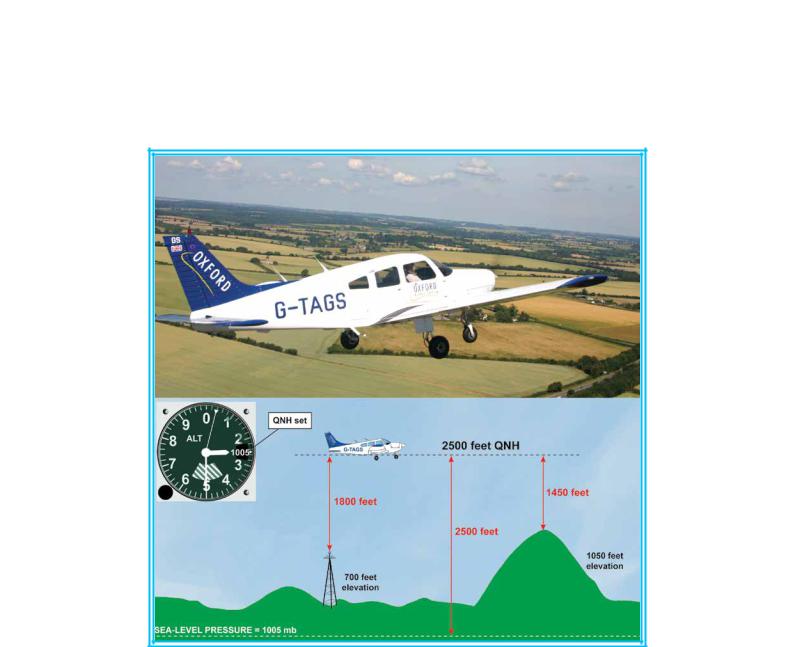
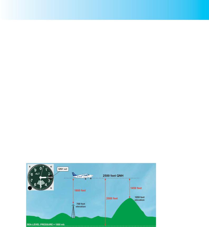
On charts, the top of all obstacles (high ground, tall buildings, radio masts etc.) is relative to mean sea-level, so, with QNH set, obstacle clearance can be assured with the help of simple arithmetic.
By subtracting the elevation of an obstacle from the altimeter reading, the pilot will know his approximate height above the obstacle.
Figure 10.4 Flying cross-country at 2500 feet with QNH set.
However, although flying on a cross-country route with QNH set will enable a pilot to compute his vertical separation from terrain and obstacles, this is not the whole story in terms of maintaining a safe altitude.
Remember, the altimeter is indicating an aircraft’s vertical separation from a pressure level; that is, the level at which the pressure prevails which is set on the altimeter
155
Order: 6026
Customer: Oleg Ostapenko E-mail: ostapenko2002@yahoo.com
Customer: Oleg Ostapenko E-mail: ostapenko2002@yahoo.com
CHAPTER 10: ALTIMETER SETTINGS
subscale. With QNH set, the pressure datum level is mean sea-level. If the pressure at sea-level changes while the aeroplane maintains level flight, the altimeter reading will change. But if the pressure changes and the aircraft flies in such a manner as to maintain a constant altimeter reading, the aircraft will either climb or descend. Let us look at an example of this latter situation.
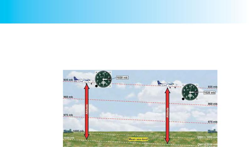
Figure 10.5 When flying into a region of falling atmospheric pressure while maintaining a constant altimeter subscale setting, the aircraft descends.
The aircraft in Figure 10.5 is leaving its departure aerodrome on a cross-country flight that the pilot intends to carry out at an altitude of 2 500 feet. The pilot has set the departure aerodrome QNH of 1020 millibars on his altimeter and elects, unwisely, to remain on that QNH for the duration of the flight. Let us assume that, unbeknown to the pilot, as he flies towards his destination aerodrome he is flying into an area of falling pressure. As we have established, because the pilot elects not to update the altimeter setting and maintains 2 500 feet as indicated by the altimeter, the changing pressure situation means that he will either climb or descend. But why should this be?
For the departure aerodrome, we know that the calculated sea-level pressure is 1020 millibars, and the pilot has set this on his altimeter subscale as the QNH. As he leaves the aerodrome at his cruising altitude of 2 500 feet indicated, the aircraft is actually flying along an invisible pressure datum line of about 935 millibars. (We can calculate the pressure at 2 500 feet fairly easily, as pressure falls at an approximate rate of 1 millibar for every 30 feet gain of height. The actual rate is 27ft/mb, but for ease of calculation, (particularly if airborne), it is easier to use 30).
If we assume that the pressure reduced to sea-level at the destination airfield is
1000 mb (this will be the destination aerodrome’s QNH), you can see from Figure 10.5 that the isobars are sloping downwards. The aircraft that we are considering, then, as it is following the 935 millibar pressure surface, will be descending along its route, even though the pilot is unaware of this because of his poor flight planning and because he is maintaining a constant altimeter reading of 2 500 feet. It is not difficult to work out that, if the destination QNH is 1000 millibars, by following the 935 millibar pressure surface, the aircraft will be only 1950 feet above sea-level when it arrives at its destination, even though the altimeter still indicates 2 500 feet. Of course, had the pilot reset the QNH to 1000 mb, the indicated 2 500 feet altitude would have reflected his true altitude. So, in the situation we have described, the aircraft’s
156