

ppl_03_e2
.pdfID: 3658
Customer: Oleg Ostapenko E-mail: ostapenko2002@yahoo.com
Customer: Oleg Ostapenko E-mail: ostapenko2002@yahoo.com
CHAPTER 13: PRACTICAL NAVIGATION
Using the en-route departure technique, the angle at which you intercept the outbound track should not be too great; an angle of between 30º and 45º is normally appropriate. Intercept the outbound track visually by looking back to your departure airfield, carry out first HAT check and then turn on to your first heading when you estimate you are on track. After turning on track, carry out your second HAT check. Your stopwatch will need to be started at an appropriate position, as you leave the aerodrome circuit. If your cruise altitude is more than a few thousand feet AGL, it might be worth a cruise climb to ensure your speed is more closely matched with your cruise speed.
Figure 13.1b En Route Departure.
EN-ROUTE.
Once en-route, and on-track, it is vitally important that you fly your pre-planned heading, altitude and speed as accurately as you can.
By flying an accurate heading and airspeed, you will stand a very good chance of arriving at your next checkpoint, turning point, or destination, on time and on track, provided the wind forecast is accurate.
If your heading and airspeed are not accurately maintained, no matter how carefully you have planned, you will soon get off track, your timing will become inaccurate and you may well end up getting lost. Your priorities on your flight must be: Aviate, Navigate, Communicate, in that order.
The key to accurate navigation
is holding your heading and airspeed accurately.
Carry out airborne taskswith
the following priorities
1.AVIATE
2.NAVIGATE
3.COMMUNICATE
237
Order: 6026
Customer: Oleg Ostapenko E-mail: ostapenko2002@yahoo.com
Customer: Oleg Ostapenko E-mail: ostapenko2002@yahoo.com
CHAPTER 13: PRACTICAL NAVIGATION
The normal work cycle in all phases of flight is:
L - Lookout
A - Attitude
I - Instruments
Regular en-route checks.
F - Fuel
R - Radio
E - Engine
D - DI
A - Altimeter Setting
Once you have settled down on track, look at your chart to remind yourself of the next event en-route, such as radio frequency change, radio calls, time at next checkpoint, then put your chart away and concentrate on flying accurately.
While continuing to fly accurately, the normal work cycle is given by the acronym LAI - Lookout - Attitude - Instruments. During the instrument scan, include the aircraft’s clock or stopwatch so that you are aware of when the next checkpoint is due. You will need to look at your chart again about 2 minutes before the checkpoint is due to appear. Another thing to consider while maintaining your heading, speed and altitude is the necessity to carry out regular FREDA checks. FREDA checks are covered in Chapter 3.
The R part of the FREDA check reminds you to confirm that you have the correct radio frequency. Once established en-route, you should consider changing to the London Information frequency, or perhaps to the Birmingham frequency, to request a Basic Service. Either of these stations will give
you the Regional Pressure Setting which you will select on the altimeter sub-scale. That should take care of the A part of the FREDA check, too.
Other actions to carry out at this early stage on the first leg are:
•Having noted the time of departure from overhead Oxford Kidlington, enter your ETA at Ludlow in the flight log.
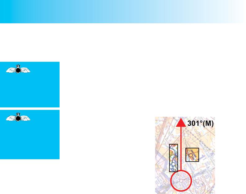
•Carry out a gross error check to confirm that you are on track. There should be a railway line lying to port, and you might expect to see the airfield at Enstone, to starboard. (See Figure 13.2.)
Figure 13.2. Check that you are on track.
Your chart should be put away at this point. You will be aware of the positions of the railway line and Enstone Airfield, from the study of the route that you made, during flight planning:
First Check Point.
According to your plan, it should take you 9 minutes to get to your first check point at
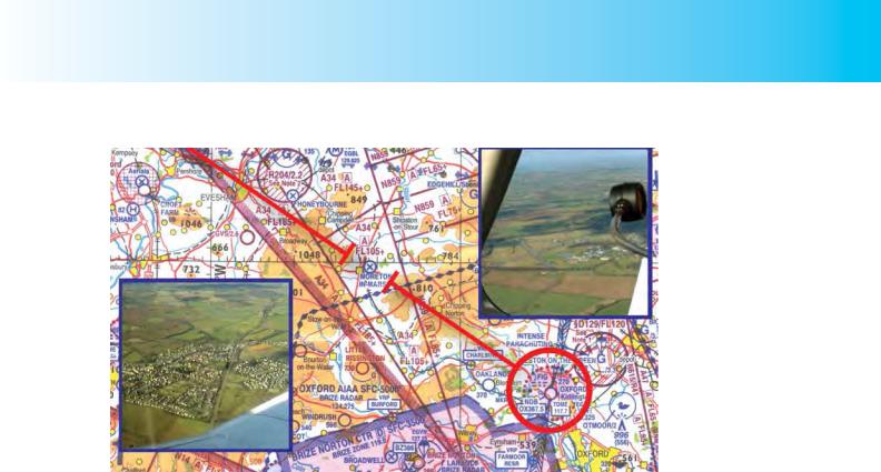
Moreton-in-Marsh, so, after 7 minutes, take out your chart and look for the checkpoint. Map read from chart to ground and from “big picture” to “little picture”. From the chart, you can see that there are two major features to look for – the disused airfield to the
North East of the town, and the railway line running roughly North to South (See Figure 13.3). These two features together will positively confirm the checkpoint.
If On Or Nearly On Track.
If you see the town of Moreton-in-Marsh directly ahead of you, then you are on track, the calculated heading is good and the wind forecast will have been fairly accurate.
However, you must note the elapsed time at which you over-fly Moreton, and if the elapsed time is not as calculated, you will need to update your estimated time of arrival (ETA) at the next checkpoint at Worcester, and at Ludlow, the turning point.
238
ID: 3658
Customer: Oleg Ostapenko E-mail: ostapenko2002@yahoo.com
Customer: Oleg Ostapenko E-mail: ostapenko2002@yahoo.com
CHAPTER 13: PRACTICAL NAVIGATION
Figure 13.3. The first checkpoint: the disused airfield at Moreton-in-Marsh, and the railway line passing through the town.
If Moreton-in-Marsh is ahead but very slightly to the left or right of your track made good, then there is a small track error which could have been caused either by inaccurate flying or because of a slightly different wind than that forecast. If you suspectthatyourflyinghasnotbeenasaccurateasitcould havebeen,flytowardsthe fix and, when over it, note the time, revise ETAs, and resume the originally calculated heading of 301° Magnetic. If, however, you feel that your flying has been accurate, estimate from your drift lines the drift which must have caused the small track error, fly towards Moreton and, when over the town, adjust your heading appropriately. If your estimated drift is, say, 2° to port, when overhead Moreton, you would adjust heading 2° starboard to 303°(M) and continue en-route. Of course, when overhead Moreton-in-Marsh you would check the elapsed time and, if necessary, revise your ETAs.
As you continue en-route, do not forget your FREDA checks at the appropriate intervals. The Direction Indicator (DI) needs resynchronising with the compass every 15 minutes or so. You should note well that, in visual navigation, headings are not maintained by sole reference to the DI or compass. Having confirmed that you have the desired heading, and are on track, look well ahead and select an appropriately prominent feature towards the horizon as a heading reference point and fly towards that feature.
If there is Significant Track Error.
If, when you get to Moreton-in-Marsh, you find that there is a significant track error, it would not be sensible to make a large change in heading to overfly the town. Such an action would compound the timing errors. If this situation arises, there are two methods of determining a new heading in order to regain track or to fly directly to your turning point or destination: These standard track-correction methods are known as the double track error method and the closing angle method. The double track error method is a suitable method to use when you are still less than half way along the leg, so we will look at the double track error method first. Let us assume that when you positively identify Moreton-in-Marsh, you see that you are to the North of the disused airfield. (See Figure 13.4.)
239
Order: 6026
Customer: Oleg Ostapenko E-mail: ostapenko2002@yahoo.com
Customer: Oleg Ostapenko E-mail: ostapenko2002@yahoo.com
CHAPTER 13: PRACTICAL NAVIGATION
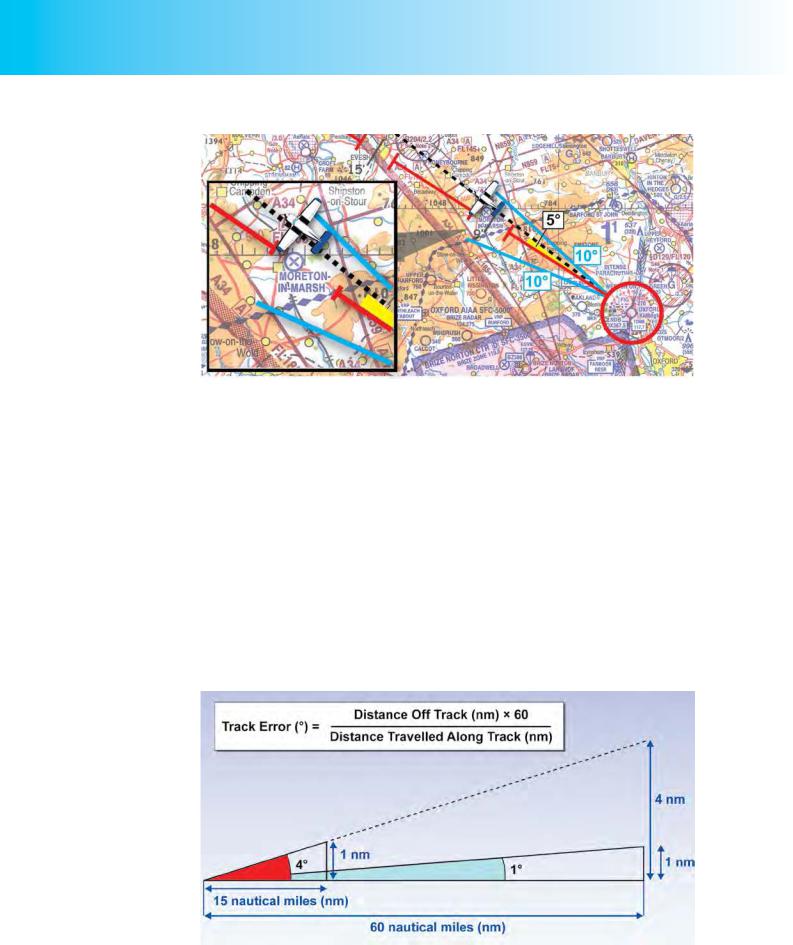
Figure 13.4 Use the Drift Lines to determine Track Error. Here the Track Error is about 5°.
You observe that the calculated elapsed time is correct and that, therefore, there is no need at present to revise your ETA for Ludlow. Having decided that you will use the double track error method to regain track, you set about estimating your track error. There are two ways of doing this. You can either refer to the drift lines on your chart or use the 1 in 60 Rule which is taught on the CD-ROM.
•Use of Drift Lines. The drift lines which you drew on your map during flight planning will help you estimate your track error. This has the advantage of not requiring any mental arithmetic; you estimate the angle by observation. In this case the drift lines indicate that you are 5° right of track.
•The 1-in-60 Rule. The 1-in-60 Rule is taught on the CD-ROM. This rule provides you with a simple mental arithmetic method of estimating angles in order to correct your heading. As Figure 13.5 shows, for a distance of 60 miles, each mile off track subtends an angle of 1º. For example, if you are one mile off track after travelling 15 miles this is the same as being 4 miles off, at 60 miles, so the track error is 4º.
Figure 13.5 The 1-in-60 Rule.
240
ID: 3658
Customer: Oleg Ostapenko E-mail: ostapenko2002@yahoo.com
Customer: Oleg Ostapenko E-mail: ostapenko2002@yahoo.com
CHAPTER 13: PRACTICAL NAVIGATION
Looking again at the chart, we will assume that you estimate your position as 1½ miles right of track and that you have flown 17 miles. The 1-in-60 Rule, taught on the
CD-ROM and summarised in Figure 13.5, indicates that you are about 5º off track.
1½ × 60
Track Error = _______ = 5° approximately 17
Double Track Error Method.
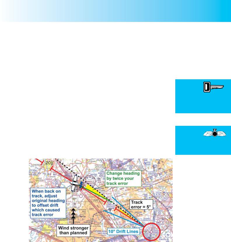
Having estimated your track error, you now have to determine by how much and for how long you need to alter heading, to regain track. If you were to alter your heading by 5°, you would be flying parallel to your desired track. However, doubling the track error and turning left by 10° will take you back towards your desired track. Let us examine how this works out.
Alter heading left from 301º to 291º, Note the time at which you make the heading change. You notice from your stopwatch that 10 minutes have elapsed since you set heading from overhead Oxford Kidlington.
Maintain the new heading of 291º for a further 10 minutes. Doing this will bring you back onto your desired track. Assuming that the original track error was the result of an innacurate wind forecast, you will not wish simply to resume your original heading of 301°(M). If the drift at your current airspeed is 5° to starboard, your original track error, you must lay off this drift, now that you are back on track, by altering your original heading 5° to port. Consequently, once back on your desired track, you steer 296°(M) in order to stay on track.
The double
track error method is
suitable for regaining
track up to the half way point on a route or leg.
When back on track,
adjust your
original heading to offset the drift which caused the track error, in order to stay on track.
Figure 13.6 Using the Double Track Error Method to Regain Track. Change heading by twice the value of the track error and fly that heading for a time equal to the time lapse at which the error was discovered.
The double track error method of regaining track is a suitable method to use to regain track up to the halfway point. Beyond that point, you should use an adaption of the double track method which we will examine shortly.
It should be easy to see that if a track-error correction using the double track error method were made exactly at the halfway point on a cross-country leg, the doubletrack error correction should take you directly to your turning point or destination.
241
Order: 6026
Customer: Oleg Ostapenko E-mail: ostapenko2002@yahoo.com
Customer: Oleg Ostapenko E-mail: ostapenko2002@yahoo.com
CHAPTER 13: PRACTICAL NAVIGATION
Revision of ETA.
If the actual wind is different from the forecast wind, it is reasonable to assume that your achieved groundspeed will be different from your calculated groundspeed. Therefore, you should pay particular attention to the elapsed time at the next checkpoint to see if this is so.
We will continue to assume that you may have ended up 5° right of track at Moreton- in-Marsh because the wind velocity was greater than forecast. If the wind was stronger, but its direction of 180°(T) was as forecast, you will also have a greater tailwind component than the one you have calculated, making your groundspeed higher than calculated, too.
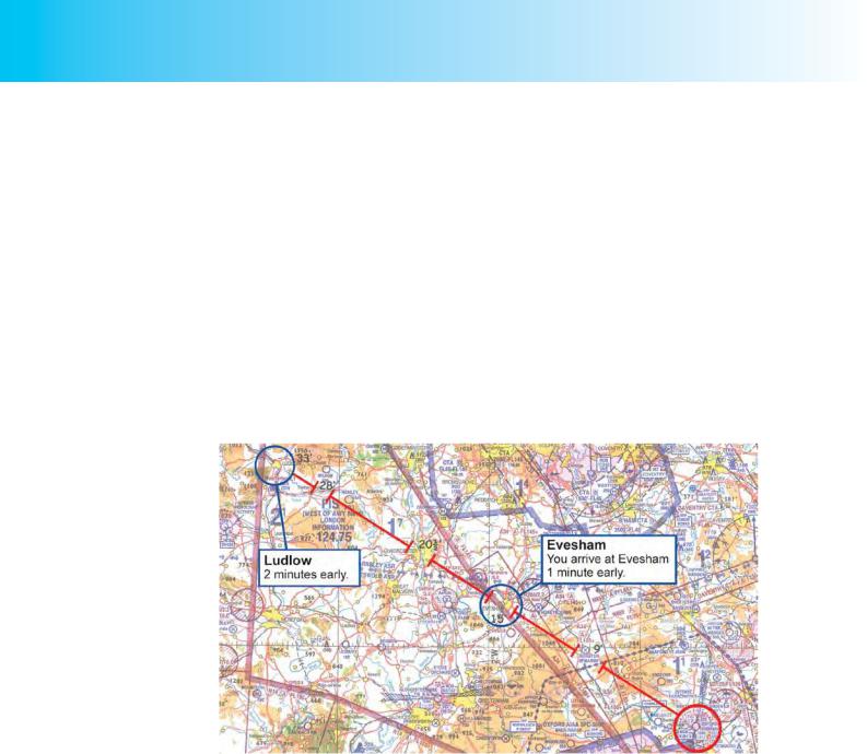
We will assume then that instead of arriving at Evesham (your second checkpoint) after 15 min, as planned, you arrive there after an elapsed time of 14 minutes. Now, Evesham is 28 miles along a track of 60 miles which is close to half way to your turning point at Ludlow. Therefore, if you are 1 minute early at the halfway point you will be 2 mins early at Ludlow.
Figure 13.7 Revision of ETA at Ludlow. If you arrive at Evesham (approximately ½ track length) one minute early, you will be two minutes early at Ludlow.
Track Error Correction after Halfway Point.
We will now examine how you would calculate an appropriate heading alteration if you were to find yourself off-track after the halfway point on your leg to Ludlow, assuming no corrections have been made since departure.
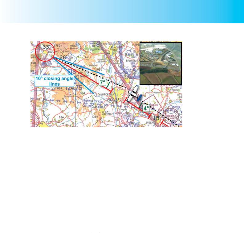
Let us assume that as you approach Worcester you find that you pass over the motorway junction to the North-East of the city rather than the junction to the SouthEast which lies on your planned track. (See Figure 13.8.) The two motorway junctions look very similar from the air so you take particular care to confirm that you are in fact approaching the junction to the North-East of Worcester.
Being only 12nm from your turning point at Ludlow, you are well beyond half way on your first leg. You cannot sensibly, therefore, use the double track error method to regain track. You need a method of track error correction which will take you directly to Ludlow. In your current situation, then, you need to estimate your track
242
ID: 3658
Customer: Oleg Ostapenko E-mail: ostapenko2002@yahoo.com
Customer: Oleg Ostapenko E-mail: ostapenko2002@yahoo.com
CHAPTER 13: PRACTICAL NAVIGATION
Figure 13.8 Calculating Track Error and Heading Correction to fly directly to Ludlow from a position North of track, at Worcester.
error with respect both to your starting point at Oxford Kidlington and to your turning point at Ludlow, and add both errors together in order to obtain the required heading correction.
This is how you proceed:
•From your chart and by direct observation you estimate your distance offtrack to be 3 nautical miles(nm).
•From your chart, with the help of the drift lines originating from Ludlow, you estimate the track error with respect to Ludlow to be 7°.
•From the 1 in 60 rule (See CD-ROM), either using your navigation computer or carrying out a mental calculation, you estimate your track error with respect to Oxford Kidlington to be 4°.
You know that Worcester is about 40 nm from Oxford Kidlington, so if you are 3 miles off track after 40 miles:
Track Error = 3 × |
60 |
= 4.5°, which we will call 4°. |
|
40 |
|
Changing heading by 4° to port would cause you to parallel your original planned track. Changing heading by a further 7° to port will take you direct to Ludlow.
You elect, therefore, to change heading 11° to port and to head directly to Ludlow. If you were still on your original heading of 301°(M), your revised heading for Ludlow would be 290°(M).
Do not forget to check the actual elapsed time at Worcester and, if it is different from the calculated elapsed time, update your ETA at Ludlow.
Carry out HAT and FREDA checks.
243

Order: 6026
Customer: Oleg Ostapenko E-mail: ostapenko2002@yahoo.com
Customer: Oleg Ostapenko E-mail: ostapenko2002@yahoo.com
CHAPTER 13: PRACTICAL NAVIGATION
When map
reading, read from
chart to ground, and from “big picture” to “little picture”.
At the start of each leg, and at checkpoints, carry out the HAT checks.
H - On Heading?
A - On Airspeed?
- At Altitude?
T - On Time?
Approaching Ludlow.
For the approach to your turning point at Ludlow, we will assume that there have been no track or timing errors and that you are approaching the turning point on track and on time. At 28 minutes, then, over Tenbury Wells, you take out your chart. Remember, you map read from chart to ground, and from big picture to little picture.
Ludlow should be easy to spot as it is a sizeable town, on its own, surrounded by high ground. That is the big picture.
The chart shows a ring road to the East of Ludlow which looks quite distinctive. Also there is a spot height of 1750 feet to the North-East and a 585 foot mast to the South. However, masts are notoriously difficult to see even in good visibility. A river skirts the town around its South-West edge and a railway line passes through the town. These latter features constitute the little picture.
Arriving at the turning point, Ludlow.
When you are overhead the town, the curve of the ring road, the path of the river and the general layout of the town should confirm that it is Ludlow.
Now, carry out the pre-HAT checks, turn and start the stopwatch, and carry out the post-HAT checks as described earlier.
Note on the flight log the actual time of arrival (ATA) at Ludlow, and work out the ETA at Hawarden.
COMMUNICATIONS.
Radio communications on a visual navigation flight which remains outside controlled airspace are normally straightforward and uncomplicated.
For this particular route, you would probably stay on the Oxford approach frequency until you were, say, 10 miles from Oxford, then change to the London Information Frequency of 124.75 MHz for a Basic Service. Note that the London Information Frequency is printed on your chart in various positions, one of which is just to the South-East of Ludlow.
Basic information on the Basic Service is at Annex 1 to this book . You will learn about the Traffic Service in Chapter 19.
You might choose to continue receiving a Basic Service from London Information until you were established on the second leg, when it might be prudent to call Shawbury for a Traffic Service or a Basic Service.
Finally, when you are about 15 nm from Hawarden, you would change to the Hawarden approach frequency to advise them of your arrival and to obtain the relevant airfield information.
244
ID: 3658
Customer: Oleg Ostapenko E-mail: ostapenko2002@yahoo.com
Customer: Oleg Ostapenko E-mail: ostapenko2002@yahoo.com
CHAPTER 13: PRACTICAL NAVIGATION
THE SECOND LEG: LUDLOW TO HAWARDEN.
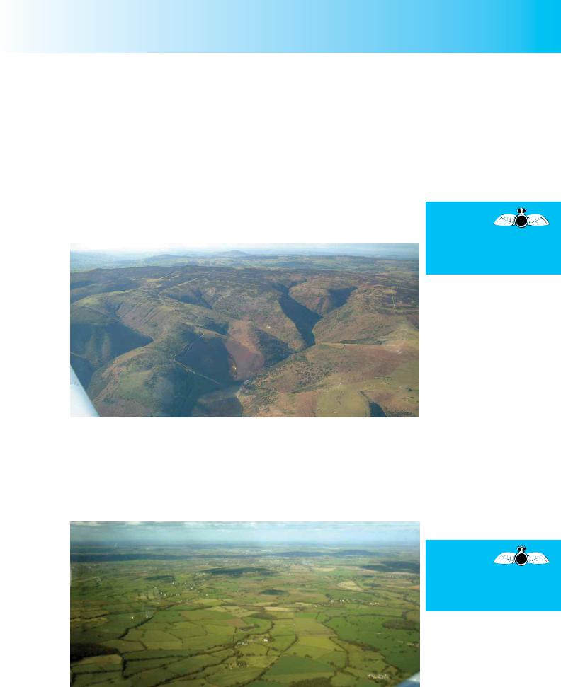
Once established on the second leg of the flight to Hawarden, with HAT checks complete, and having also carried out a further, regular FREDAcheck, you concentrate on flying an accurate heading and airspeed. Having carefully studied your route during the flight planning stage, and just having put your chart away following your arrival at Ludlow, you do not need to consult your chart to confirm that you have high ground around the Long Mynd on your port side (see Figure 13.9), and that you will soon be approaching the town of Church Stretton, also on your left. These observations constitute the big picture confirmation, or gross error check, that you should make as you begin each new leg. You should arrive at Church Stretton about 2 minutes before your first checkpoint at the road-bridge over the railway line, SouthWest of the disused airfield at Condover.
At the start of each new leg, carry out a
gross error (big picture) check to confirm that you are heading in the planned direction.
Figure 13.9. Early on the second leg, you note the high ground around the Long Mynd to the left of track.
A Missed Checkpoint.
You realise that the road bridge over the railway line is going to be a difficult ground feature to spot, and you suspect that, for that reason, you may have been mistaken in choosing it. Nevertheless, you are expecting to over-fly it, 8 minutes out from Ludlow. So, after 6 minutes you take out your chart to remind yourself of the ground features running up to the checkpoint, and begin looking for it.
Do not choose
as checkpoints ground
features which are not distinctive enough to spot easily.
Figure 13.10. Checkpoints which are not distinctive or prominent enough may be very difficult to spot.
245
Order: 6026
Customer: Oleg Ostapenko E-mail: ostapenko2002@yahoo.com
Customer: Oleg Ostapenko E-mail: ostapenko2002@yahoo.com
CHAPTER 13: PRACTICAL NAVIGATION
If you fail
to spot a checkpoint
but have no reason to doubt your flying accuracy, maintain heading, speed and altitude, and note the time at which the next checkpoint is due to appear.
To be able
accurately to maintain
heading and airspeed is an essential skill of the pilot-navigator.
The 8 minutes elapsed time interval approaches and passes, but there is no sign of the bridge. You feel sure it is there somewhere, but you just cannot see it. Perhaps you are slightly to the right of track and it is underneath you. You look out to the right to try to spot Condover airfield but you do not see that either.
You have no reason to doubt your flying accuracy, or the forecast wind, and so, quite correctly, you decide to ignore that checkpoint and continue to fly the aircraft accurately towards the next checkpoint, maintaining heading and airspeed. For the time being you must assume that you are on track.
Re-establishing Your Position.
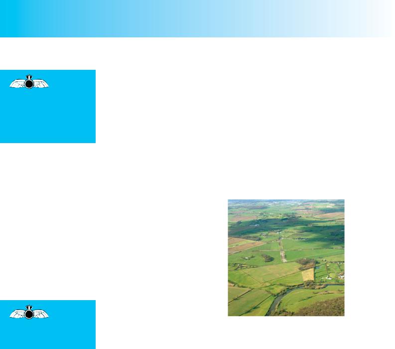
Almost immediately, you see Shrewsbury in front of you just to the right of the track you are making, so you know that you are very close to your planned track. With your next checkpoint of the disused airfield at Montford Bridge only 3 minutes away, you continue concentrating on accurate flying and, after a further minute, take out your chart and begin looking ahead for Montford Bridge airfield which, you see, lies just beyond a loop in a river.
After a very short period of looking, you see the distinctive runway pattern of the disused airfield of Montford Bridge ahead of you, beyond a river. (See Figure 13.11.)
So, despite having missed a checkpoint, you have continued to hold your heading and airspeed and have been able to confirm that you are, in fact, exactly on track.
To be able accurately to maintain heading and airspeed is an essential skill of the pilot-navigator. If you can master that skill, and if your pre-flight planning is thorough and comprehensive, following the teaching of the previous chapters, you will find that mental dead reckoning (MDR) visual navigation techniques can
be very accurate. Using MDR techniques you should, given a good wind forecast, be able to maintain track, or be able quickly to determine your track error and take appropriate remedial action to put yourself back on track, or to fly directly to your next turning point, or your destination.
If you were early or late at Montford Bridge, you could easily revise your ETA at Hawarden. At 23 nautical miles from Ludlow, Montford Bridge is just about half way to Hawarden, so any elapsed time error at Montford Bridge merely needs to be doubled to obtain a revised ETA for Hawarden. If you were one minute late at Montford Bridge, you would be 2 minutes late at Hawarden. If you were 2 minutes early at Montford Bridge, you would be 4 minutes early at Hawarden, and so on.
Furthermore, because Montford Bridge is half way between Ludlow and Hawarden, any track error you observe at Montford Bridge just needs to be doubled to obtain a heading which should take you directly to Hawarden. For Instance, if you were 2 miles to the left of track at Montford Bridge airfield, you can easily estimate your track error using the 1 in 60 rule.
246