

ppl_03_e2
.pdfID: 3658
Customer: Oleg Ostapenko E-mail: ostapenko2002@yahoo.com
Customer: Oleg Ostapenko E-mail: ostapenko2002@yahoo.com
CHAPTER 10: ALTIMETER SETTINGS
true altitude is reducing while its indicated altitude remains the same. This is a potentially hazardous situation, especially in poor visibility. However, the situation is hazardous in good visibility, too, because an ATZ, Control Zone, or Danger Area could be penetrated when a pilot thinks he is passing above the Zone or Area.
Therefore, a pilot must exercise particular caution when flying into an area of falling atmospheric pressure.
In the opposite situation, flying towards a high pressure area, an aircraft which maintained a constant indicated altitude, without the pilot updating the QNH, would actually be climbing. Though this situation is not hazardous from the terrain clearance point of view, a pilot may unwittingly enter an airway and cause danger to himself and others as a result.
Consequently, it is of the utmost importance that the pilot should update the QNH regularly. This updating of QNH along a cross-country route may be effected by requesting QNH from aerodromes along the route, or, if in the United Kingdom, by requesting the Regional Pressure Setting.
Regional Pressure Setting.
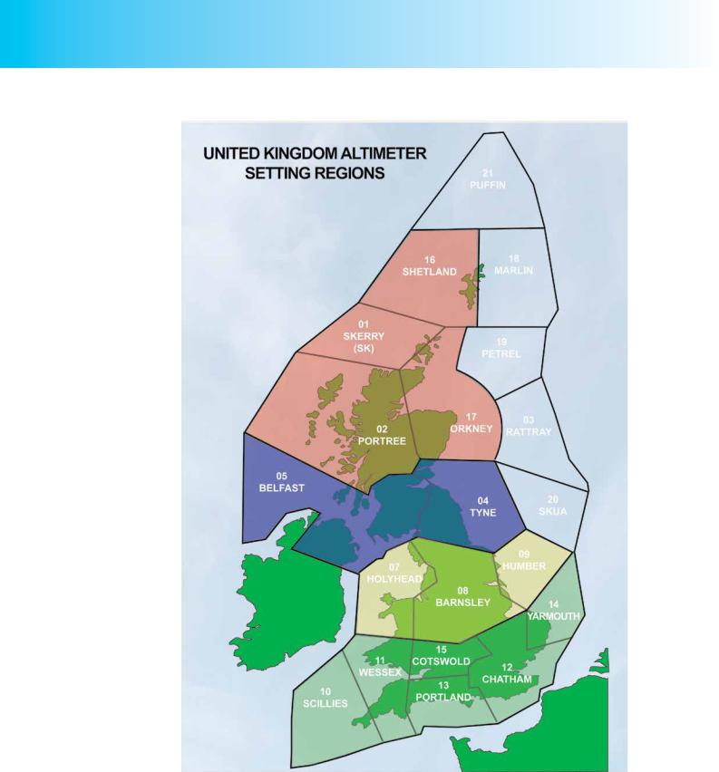
The United Kingdom is divided into a number of Altimeter Setting Regions (See Figure 10.6) for each of which the Met Office calculates the lowest forecast pressure, for the next two hours. These pressure settings are known as Regional Pressure Settings. Regional Pressure Settings are updated every hour.
The Regional Pressure Setting (RPS) may be obtained from all aerodromes providing an Air Traffic Service, or on the London, Manchester or Scottish Flight Information
Service frequencies. The purpose of RPS is to enable pilots to maintain safe terrain clearance when a local aerodrome QNH is not available. Because of the nature of the RPS, and its purpose, an altimeter with RPS set on it will always indicate lower than the actual altitude. RPS must not be used as the vertical reference in the vicinity of controlled airspace.
When approaching the destination airfield, the pilot will be given the QNH of the aerodrome, and possibly also its QFE.
Update
aerodrome QNH at
appropriate
intervals and, when on a cross-country flight, make sure that you have the correct Regional Pressure Setting on your altimeter.
157
Order: 6026
Customer: Oleg Ostapenko E-mail: ostapenko2002@yahoo.com
Customer: Oleg Ostapenko E-mail: ostapenko2002@yahoo.com
CHAPTER 10: ALTIMETER SETTINGS
Figure 10.6 United Kingdom Altimeter Setting Regions.
Remaining Clear of the Base of Controlled Airspace.
Control Zones (CTRs) and Control Areas (CTAs), with certain exceptions, are not part of the Altimeter Setting Region network. Therefore, when flying near to the base of a
CTA (or TMA), pilots must obtain a QNH from a nearby aerodrome in order that they may avoid, unwittingly, entering the CTA/TMA from beneath. When flying beneath
158
ID: 3658
Customer: Oleg Ostapenko E-mail: ostapenko2002@yahoo.com
Customer: Oleg Ostapenko E-mail: ostapenko2002@yahoo.com
CHAPTER 10: ALTIMETER SETTINGS
an airway whose base is expressed as an altitude, pilots are likewise recommended to obtain a QNH from an adjacent aerodrome, in order to avoid entering the base of the airway.
THE STANDARD PRESSURE SETTING OF 1013.2 MILLIBARS.
During flights well above terrain, changes in atmospheric pressure along a route, and over time, are not so critical to terrain clearance considerations. At these higher altitudes, the fact that a pilot may fly over long distances without updating the altimeter subscale pressure setting will not endanger the aircraft. In fact, having all aircraft use the same altimeter subscale setting, above a defined altitude, will actually help an Air Traffic Control Unit (ATCU) maintain vertical separation between the aircraft that the
ATCU is controlling or in communication with.
So, by international agreement, above a certain defined altitude, called the transition altitude, which varies from country to country and even, in some cases, from aerodrome to aerodrome, the Standard Pressure Setting (SPS) of 1013.2 mb (or hPa) is used. The use of the SPS is obligatory in controlled airspace above the transition altitude, and strongly recommended for VFR flights conducted above the transition altitude, outside controlled airspace. For IFR flights, the use of the SPS is obligatory above the transition altitude, both inside and outside controlled airspace.
THE TRANSITION ALTITUDE.
Transition altitudes are established by national aviation authorities to meet the air traffic and flight safety requirements of local conditions. Obviously, over countries with lots of mountainous areas, the transition altitude will be higher than over lowlands. The transition altitude in the United Kingdom is 3000 feet over most of the country and at all aerodromes, unless otherwise notified. There are exceptions, however. For example, the London TMA, Cardiff and Bristol have a transition altitude of 6000 feet; Manchester has a transition altitude of 5000 feet, and East Midlands and Birmingham 4000 feet. Wherever possible, there is a common transition altitude for all aerodromes within a Control Zone.
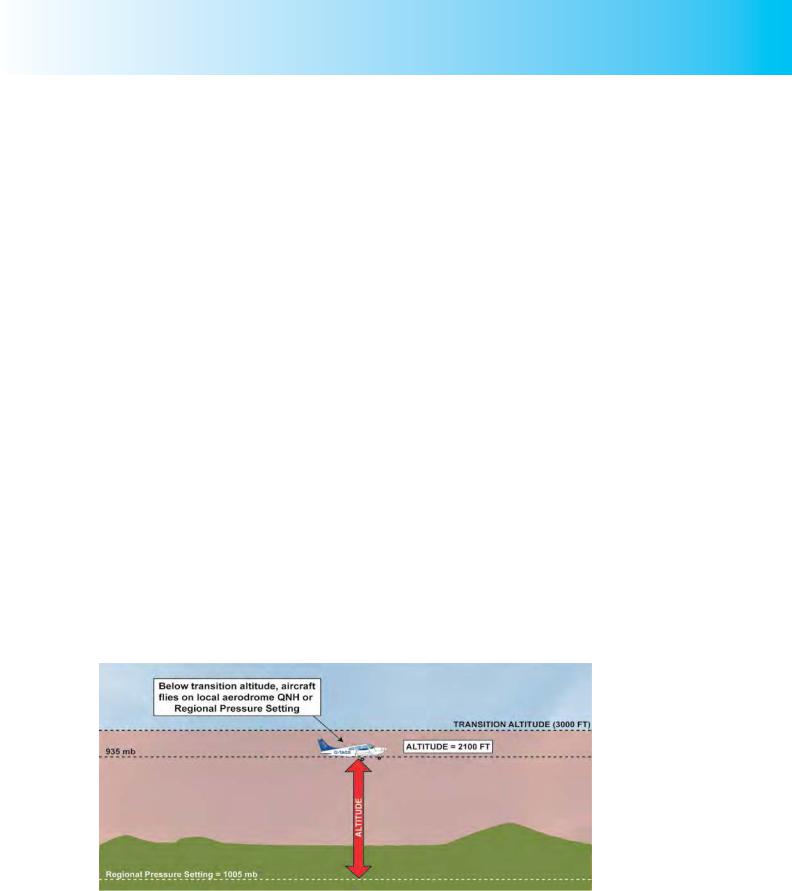
Figure 10.7 Cruising below a transition altitude of 3000 feet with Regional Pressure Setting or local Aerodrome QNH set on the altimeter subscale.
159
Order: 6026
Customer: Oleg Ostapenko E-mail: ostapenko2002@yahoo.com
Customer: Oleg Ostapenko E-mail: ostapenko2002@yahoo.com
CHAPTER 10: ALTIMETER SETTINGS
Maximum Elevation Figures are not Safety Altitudes.
Above the transition
altitude, with the SPS of
1013 mb set on the altimeter, altimeter indications are referred to as Flight Levels.
In the United States, the transition altitude over the whole country is 18 000 feet. In New Zealand, the transition altitude is generally 13 000 feet.
Whenflyingbelow thetransition altitude,pilotssetanaerodromeQNHortheRegional
Pressure Setting (RPS) on the altimeter in order that they can maintain separation with terrain and obstacles. (See Figure 10.7.)
Typically, on a cross-country flight, a VFR pilot will have studied the ICAO 1:500 000 topographical chart closely. The elevation of all high ground and obstacles will be given on the chart so the pilot will know the vertical distance of hill tops and obstacle summits from sea-level. By subtracting known elevations from his altimeter reading, with QNH or RPS set, he will know how high he is above the terrain.
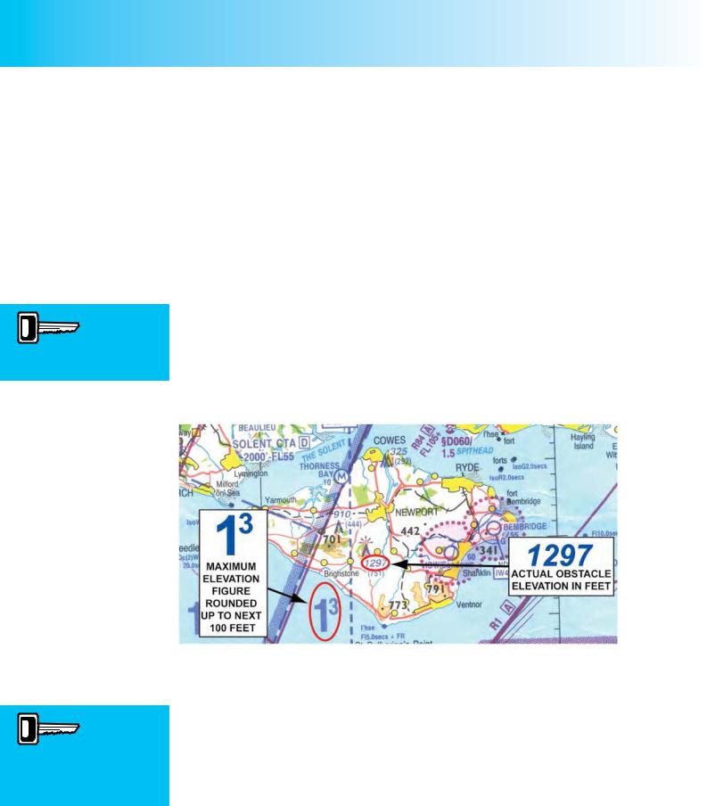
1:500 000 charts also show Maximum Elevation Figures (MEF) in quadrants marked on the chart. The MEFs, as the name suggests, show the elevation of the highest known features in each quadrant, expressed in thousands and hundreds of feet above mean sea-level. Natural obstacles (hills, etc.), will have 300ft added to allow for possible undeclared small structures such as masts. Elevations are rounded UP to the next whole hundred feet. Figure 10.8 highlights an MEF of 1 300 feet for the Isle of Wight which indicates a tower whose actual elevation is 1297 feet above mean sea-level. Note that an MEF is not a Safety Altitude.
Figure 10.8 Maximum Elevation Figures on the Isle of Wight. With the altimeter set to QNH or RPS, the pilot can compute the vertical separation between his aircraft and terrain or obstacles.
Above the transition altitude the SPS of 1013 mb is set. When an aircraft is equipped with two or more altimeters, it is standard practice when flying above the transition altitude, that one altimeter should remain set to QNH so that the pilot may still know his clearance from terrain. Above the transition altitude, with 1013.2 mb (hPa) set on the altimeter subscale (the pilot can only dial up the digits 1013, of course), the indications on the altimeter are referred to as Flight Levels.
When air traffic controllers and pilots transmit Flight Levels over the radio, or when
Flight Levels are written down, the last two zeros of the altimeter reading are omitted.
So, when flying by reference to Flight Levels above the transition altitude, with 1013 mb (hPa) on the altimeter, an altimeter indication of 5000 feet would be referred to as
160

ID: 3658
Customer: Oleg Ostapenko E-mail: ostapenko2002@yahoo.com
Customer: Oleg Ostapenko E-mail: ostapenko2002@yahoo.com
CHAPTER 10: ALTIMETER SETTINGS
Flight Level 50; an indicated 6500 feet would be referred to as Flight Level 65, and an altimeter reading of 15 000 feet would be referred to as Flight Level 150.
Under IFR, Flight Levels are not established for every altimeter reading with the SPS set on the subscale. Flight Levels (FL) are given for intervals of 500 feet between transition altitude and FL 250 and at intervals of 1000 feet above FL 250; e.g. FL 35, FL 40, FL 45 and so on up to FL 245; then FL 250, FL 260, FL
270 and so on. Under VFR, any FL can be flown.
Flight Levels are used principally to maintain adequate separation between aircraft flying in accordance with Instrument Flight Rules (IFR). Under VFR, any FL can be flown. But pilots flying in accordance with the Visual Flight Rules (VFR) in controlled airspace must also use SPS and fly by reference to Flight Levels when instructed to do so by the ATCU.
With all aircraft flying at Flight Levels, invariably during the en-route phase of flight, Air Traffic Controllers know that all aircraft are flying at vertical distances from the same pressure datum level of 1013.2 mb (hPa). In these circumstances, with altimeter indications referenced to the same standard pressure datum level, Air
Traffic Controllers can safely allocate Flight Levels to the aircraft under their control and be confident that vertical separation will be maintained if pilots keep to their assigned levels.
At this point, it is pertinent to give a formal definition of the transition altitude.
The ‘transition altitude’ is the altitude at or below which the vertical position of an aircraft is normally monitored by reference to altitude.
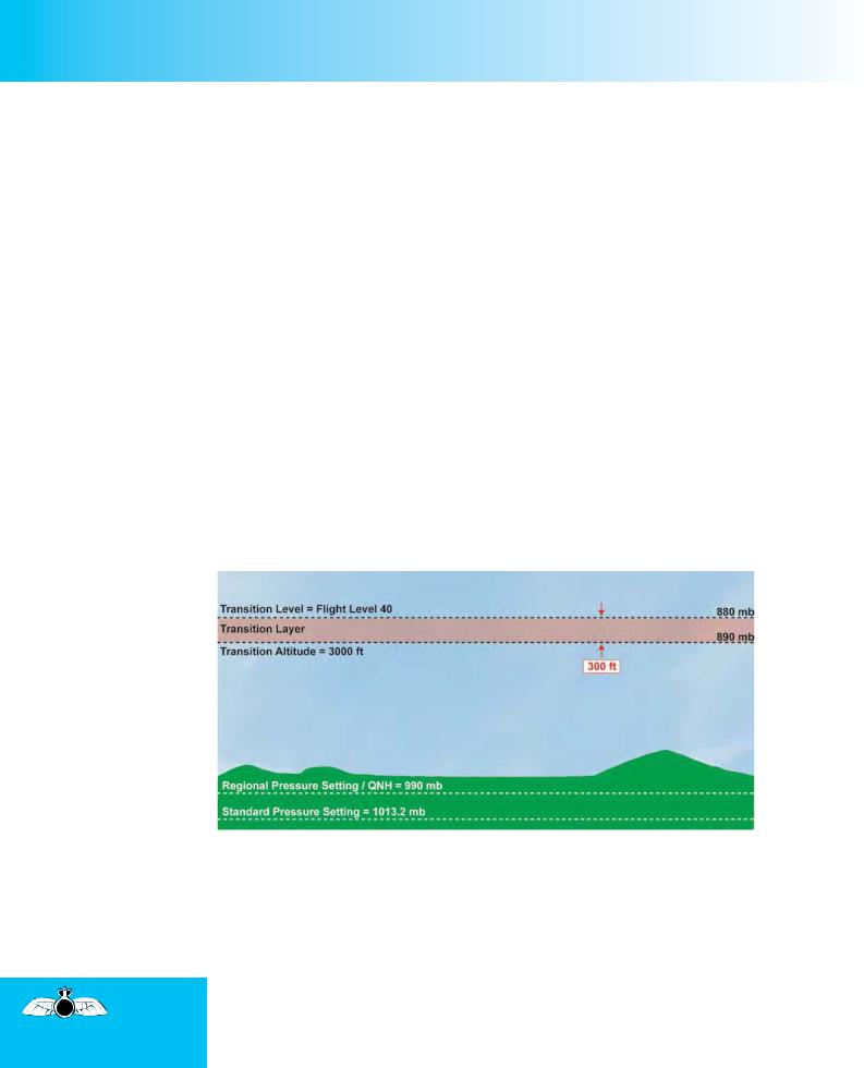
Fig 10.9 Cruising above and below the Transition Altitude.
The transition level is always above the transition altitude.
Below the transition altitude, an aircraft flying cross-country, in the United Kingdom, will normally have the Regional Pressure Setting (RPS) on the subscale of its altimeter (though it may have a local aerodrome QNH set), and will refer to its vertical position as altitude. Above the transition altitude, the aircraft will normally have the SPS of 1013.2 mb set on the altimeter, and will refer to its vertical position as a Flight Level.
The transition
altitude is the altitude at or
below which
the vertical position of an aircraft is normally monitored by reference to altitude.
161
Order: 6026
Customer: Oleg Ostapenko E-mail: ostapenko2002@yahoo.com
Customer: Oleg Ostapenko E-mail: ostapenko2002@yahoo.com
CHAPTER 10: ALTIMETER SETTINGS
For example, in Figure 10.9 previous page, the RPS is 1005 mb, and the transition altitude is 3000 feet, as is standard outside controlled airspace in the United Kingdom. For an RPS of 1005 mb, 3000 feet represents a pressure level of about 905 mb. (Remember, atmospheric pressure falls by 1 mb for every 30 feet gain of height. So, 3000 feet represents approximately 1005 mb – (3000/30) mb = 1005 mb – 100 mb = 905 mb.) The lower aircraft, cruising below the transition altitude, is at an altitude of 2000 feet. In other words, the aircraft is flying at 2000 feet above mean sea-level, along the 938 mb isobar.
The higher aircraft, flying above the transition altitude, and so has 1013 mb set on its altimeter subscale. The pilot has elected to fly at 4500 feet indicated, and will report his vertical position as Flight Level 45. The aircraft is, of course, flying at 4500 feet above the pressure datum of 1013.2 mb, and will be flying along the 863 mb pressure surface.
NB: The above pressure calculations are for illustration purposes only; you do not need to know the actual pressure at your cruising level, only the required altimeter subscale setting (QNH/RPS/SPS).
THE TRANSITION LEVEL.
The lowest Flight Level above the transition altitude which is available for use is called the transition level (TL). The airspace between the transition level and the transition altitude is called the transition layer. (See Figure 10.10.)
The transition level always lies above the transition altitude.
Fig 10.10 The Transition Level is the lowest available Flight Level above the Transition Altitude. Here, the Transition Level is FL 40, and the Transition Layer is 300 feet deep.
The transition altitude is, as you have learnt, an altimeter indication established by the national aviation authority. Above the United Kingdom it is 3000 feet, unless otherwise notified. The transition altitude, like any other altitude, is measured against a constantly changing value of sea-level pressure which is passed to the pilot as an aerodrome QNH or Regional Pressure Setting (RPS).
The transition level, however, is not set at a level identified by a given altimeter indication, but is measured against the constant pressure datum for Flight
Levels of 1013 mb (hPa). So the Flight Level which identifies the transition level (i.e. the lowest useable Flight Level above the transition altitude) will change with changing QNH or RPS , but TL cannot be physically below TA.
162
ID: 3658
Customer: Oleg Ostapenko E-mail: ostapenko2002@yahoo.com
Customer: Oleg Ostapenko E-mail: ostapenko2002@yahoo.com
CHAPTER 10: ALTIMETER SETTINGS
This is not an easy concept to grasp, so let us examine the issue using an actual example.
Take a look again at Figure 10.10. In the diagram, the QNH (or RPS) is 990 millibars.
The transition altitude is shown as being 3000 feet above that pressure datum. The
Standard Pressure Setting (SPS), of 1013.2 mb will, in this situation, lie below the
QNH datum.
A Flight Level is, as you have learnt, measured as a vertical position measured with reference to the SPS. Furthermore, the transition level, which is the lowest useable Flight Level on any given day, must lie above the transition altitude.
So what Flight Level represents the transition level in the circumstances depicted in
Figure 10.10?
We know that the transition altitude of 3000 feet is 3000 feet above the RPS of 990 mb, so it will, necessarily, be at a greater vertical distance above the 1013.2 mb. This SPS datum is, in fact, 23.2 mb “lower” than the RPS datum. At 30 feet per millibar, that makes the SPS datum almost 700 feet lower (696 feet, to be exact), and puts the transition altitude of 3000 feet at 3700 feet above the SPS datum. Consequently, the lowest available Flight Level above the transition altitude is Flight Level 40; i.e., 4000 feet above the SPS datum of 1013.2 mb at a pressure level of 880 mb. Naturally, in these conditions, the transition layer will be 300 feet in depth. Note, too, that at Flight Level 40, in the prevailing conditions illustrated in Figure 10.10, an aircraft will be only 3 300 feet above sea-level, not the 4 000 feet indicated on the altimeter.
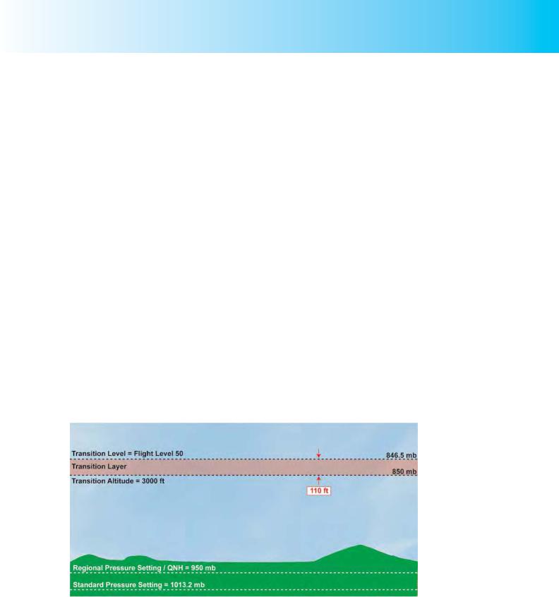
By a similar calculation process, if the QNH/RPS were 950 mb, the lowest available
Flight Level, the transition level would be Flight Level 50. (See Figure 10.11.)
Fig 10.11 In the atmospheric pressure conditions depicted here, the Transition Level is
FL 50, and the Transition Layer is 110 feet deep.
The SPS datum level would be 63 mb or approximately 1890 feet (63 x 30) lower than the RPS datum, making the transition altitude of 3000 feet, 4890 feet above the SPS datum, and giving a lowest available Flight Level of Flight Level 50. An aircraft would, of course, have to climb 110 feet to get from the transition altitude to the transition level of Flight Level 50. The transition layer would be, in this case,
163

Order: 6026
Customer: Oleg Ostapenko E-mail: ostapenko2002@yahoo.com
Customer: Oleg Ostapenko E-mail: ostapenko2002@yahoo.com
CHAPTER 10: ALTIMETER SETTINGS
Outside controlled
airspace, when flying
above the transition level, IFR traffic must, and VFR traffic should, follow the Quadrantal Rule
therefore, about 110 feet deep, and at Flight Level 50, the aircraft is only 3110 feet above sea level.
Looking at this situation from a slightly different perspective, let us imagine that, with a QNH of 950 mb set, a pilot has just approached the transition altitude of 3000 feet. He now resets 1013 mb on his altimeter subscale, winding on 63 mb to change the subscale setting from 950 to 1013. At 30 feet per millibar, the pilot sees his altimeter indication rise from 3000 feet to 4890 feet. The pilot knows, therefore, that he must climb a further 110 feet to give an altimeter reading of 5000 feet. As he now has the SPS in his altimeter subscale, that puts him at Flight level 50. But the aircraft remains only 3110 feet above sea-level. Hence the importance of flying with QNH or
RPS in the altimeter subscale when descending below the transition level.
Care should be taken in conditions of abnormally low atmospheric pressure when an altimeter set to SPS may indicate an apparently safe altitude while the actual altitude is much lower. Note that,if ambient pressure is sufficiently above Standard, (by about 20mb), the Transition Level may be numerically lower than TA (e.g. FL25), but can never be physically below it.
FLIGHT AT OR ABOVE THE TRANSITION LEVEL.
Inside Controlled Airspace.
If a pilot is flying inside controlled airspace, above the transition altitude, he must set the Standard Pressure Setting (SPS), 1013 mb (hPa), on his altimeter, and report his level to the responsible Air Traffic Control Unit (ATCU) as a Flight Level. If a second altimeter if fitted to the aircraft, the pilot should set the Regional Pressure
Setting (RPS) or appropriate aerodrome QNH on that altimeter in order that he may compute his vertical distance from terrain and obstacles. When descending below the transition level in controlled airspace, the ATCU will pass the appropriate RPS/ QNH to the pilot.
Outside Controlled Airspace.
Outside controlled airspace, when above the transition altitude, in level flight, an aircraft flying in accordance with the Instrument Flight Rules (IFR) must set the SPS on his altimeter (1013 mb) and, if below Flight Level 195, fly at a Flight Level determined by the aircraft’s magnetic track, as stipulated by the Quadrantal Rule. The Quadrantal Rule is based on magnetic track, and effectively, divides all possible magnetic tracks into four sectors, confining aircraft to specific Flight Levels within each sector. Magnetic tracks are used as the reference instead of magnetic heading because slow moving aircraft are affected much more by drift than high-speed aircraft. Consequently, aircraft may well be on converging tracks even when steering the same compass heading. The Quadrantal Rule is summarized in Figure 10.12.
The simple procedure for flying in accordance with the Quadrantal Rule is:
1.The pilot determines the magnetic track he needs. This is normally done on the ground during the flight planning stage.
2.The pilot chooses a cruising level appropriate to his magnetic track and compliant with the Quadrantal Rule.
164

ID: 3658
Customer: Oleg Ostapenko E-mail: ostapenko2002@yahoo.com
Customer: Oleg Ostapenko E-mail: ostapenko2002@yahoo.com
CHAPTER 10: ALTIMETER SETTINGS
The
Quadrantal Rule is
based on an
aircraft’s magnetic track.
Fig 10.12 The Quadrantal Rule - to be followed when flying IFR or VFR outside controlled airspace, above the transition altitude but below FL 195.
Pilots flying in accordance with the Visual Flight Rules (VFR) above TA, while not obliged to fly Flight Levels, are strongly advised to set their altimeters to the SPS and to fly at a Flight Level compliant with the Quadrantal Rule.
Following the Quadrantal Rule may often be the only systematic way to ensure separation from other aircraft when flying VFR in marginal visual conditions above the transition level.
ALTIMETER SETTING PROCEDURES.
The following general altimeter setting procedures should be used by VFR flights.
Take-off, Climb and Cruise.
Outside controlled airspace, there is no stipulated altimeter subscale setting. However, the following considerations should be borne in mind:
•If departing on a cross-country flight, aerodrome QNH will be an appropriate altimeter setting for the take-off, climb out and cruise within 25nm of the aerodrome (being more accurate than an RPS, which is a lowest forecast value). At the selected cruising level, if below the transition altitude, obtain the RPS through a Flight Information Service or Lower Airspace Radar Service and set as required, adjusting altitude to the chosen cruising level.
•If passing below a Control Area (CTA) or Terminal Control Area (TMA), the QNH of an aerodrome situated beneath the CTA/TMA should be used.
•Above the transition altitude, VFR pilots are strongly advised to set the
Standard Pressure Setting (SPS) of 1013 mb on their altimeter and to fly at a Flight Level appropriate to their magnetic track in accordance with the Quadrantal Rule.
At a controlled airfield, a VFR pilot will often be given both the aerodrome QNH and QFE from the Air Traffic Control Unit (ATCU), before take-off. Within a Military Aerodrome Traffic Zone (MATZ), pilots will normally be given the airfield QFE.
When Flying
beneath a CTA or TMA,
the QNH of
an aerodrome located beneath the CTA/TMA should be set on the altimeter subscale.
165

Order: 6026
Customer: Oleg Ostapenko E-mail: ostapenko2002@yahoo.com
Customer: Oleg Ostapenko E-mail: ostapenko2002@yahoo.com
CHAPTER 10: ALTIMETER SETTINGS
•On leaving the CTR, Aerodrome Traffic Zone (ATZ) or MATZ, the ATCU controller will normally pass the Regional Pressure Setting to the pilot. If the pilot remains underneath a CTA or TMA on leaving the CTR, ATZ or MATZ, he should remain on aerodrome QNH.
•At and above the transition altitude, if the pilot remains in controlled airspace, he should set the SPS of 1013 mb on his altimeter and report all levels as Flight Levels.
•If, in controlled airspace, the aircraft is below the transition altitude, the pilot will be passed the appropriate QNH, or QFE from a military airfield, by the responsible ATCU.
Approach and Landing.
Approaching an aerodrome with a CTR or ATZ.
•When descending from above the transition level, where the aircraft will have been flying at a Flight Level, the aerodrome QNH will be passed by the CTR controller or Aerodrome Flight information Service Officer (AFISO). On vacating his Flight Level to commence the descent, the pilot will replace the SPS on his altimeter by the aerodrome QNH, unless a CTR controller wishes him to continue reporting Flight Levels in the descent.
•When descending from below the transition altitude with the RPS set, the CTR controller or AFISO will pass the aerodrome QNH to the pilot, who should select it immediately, in place of the RPS. If the aircraft has been cruising below a TMA or CTA immediately prior to the descent, it will have the aerodrome QNH set on the altimeter already.
•A clearance will be required to enter a CTR around a destination aerodrome.
•Normally the aerodrome QNH will be kept on the altimeter for the circuit and approach to land. If a circuit altitude is not published, add the airfield elevation to the circuit height (standard is 1 000 ft) to obtain circuit altitude. However, the pilot may be passed the QFE. He may also, of course, request the QFE.
Approaching an aerodrome with only an Air-Ground Radio Service.
•When descending from a Flight Level above the transition altitude, obtain the
RPS from an Air Traffic Service Unit providing a Flight Information Service or
Lower Airspace Radar Service. On making contact with the air-ground radar service, an advisory QNH or QFE may be given. If not, the pilot will have to retain the RPS on his altimeter for the circuit and approach to land, making sure to add the aerodrome elevation to all altimeter readings in the circuit in order to maintain the correct height above airfield level at all times.
•When descending from below the transition altitude the RPS or an aerodrome QNH from a nearby ATSU will normally already be set. On making contact with the air-ground radar service, the pilot may have to retain the RPS or QNH on his altimeter for the circuit and approach to land. If so, the pilot must
166