

ppl_03_e2
.pdfID: 3658
Customer: Oleg Ostapenko E-mail: ostapenko2002@yahoo.com Customer: Oleg Ostapenko E-mail: ostapenko2002@yahoo.com
This situation changed in 1878 when, by international agreement, the Earth was divided into time zones, see Figure 2.3, within which all localities had the same local time, which was designated the standard time for that zone, thus enabling large regions of the world, most often including complete nations, to work to the same standard time. There are 24 time zones each centred on meridians of longitude spaced at 15° intervals, 15° being the angle which subtends the longitudinal arc that
the Sun appears to trace out in one hour.
A few years later, in 1884, again by international agreement, the meridian of longitude passing through the Royal Observatory in Greenwich, London, was designated the prime or zero meridian. (The red numbers in Figure 2.3 are corrections to apply to local time to obtain GMT/UTC).
Seven and a half degrees either side of the Greenwich Meridian (7½° West to 7½° East) was designated as a given time zone, and the other 23 time zones were set out after that pattern. The standard time in the time zones to the East of Greenwich is ahead of Greenwich by one hour for every 15° of longitude, and standard time in zones to the West of Greenwich is behind Greenwich by one hour for every 15° of longitude.
The time difference between the various time zones is, therefore, a whole number of hours. Minutes and seconds within all zones are the same. For instance, when the standard time is 6:45 in the afternoon in Sofia, Bulgaria, the standard time in
London, England is 4:45 in the afternoon.However, as you can see from the map of European Time Zones at Figure 2.4, below, the exact boundaries of time zones are set by governments to make allowance for national borders and physical geography. The boundary lines of time zones, therefore, sometimes deviate considerably from the line of the meridian of longitude on which the time zone is based.
Figure 2.4 European Time Zones
CHAPTER 2: TIME
All localities
within a given time
zone have the same local time which is designated “standard time”.
The Earth’s
24 time zones are centred
on meridians of longitude spaced at 15º intervals, 15º being the angle which subtends the longitudinal arc through which the Sun
appears to move in one hour.
Time zones
to the East of Greenwich
are ahead if Greenwich by one hour for every 15º of longitude. Time Zones, to the West of Greenwich are
behind Greenwich by one hour for every 15º of longitude.
17

Order: 6026
Customer: Oleg Ostapenko E-mail: ostapenko2002@yahoo.com CHAPTER 2: TIMECustomer: Oleg Ostapenko E-mail: ostapenko2002@yahoo.com
In the United Kingdom, the standard time throughout the year is Greenwich Mean Time (GMT), though the UK does also shift to British Summer Time from March to October. GMT has now been superseded by Coordinated, Universal Time (UTC), which, however, is, as near as makes no difference, the same as GMT.
The borders of nations whose territory covers extensive areas of the Earth’s surface encompass several time zones. The continental United States of America cover four time zones, each having its own standard time: Eastern Time, Central Time,
Mountain Time and Pacific Time. (See Figure 2.5.)
The International
Date Line in the mid-Pacific Ocean separates two consecutive calendar days in a practical way.
Figure 2.5 Time Zones of the Continental U.S.A.
The International Date Line.
The 180° East meridian, in the mid-Pacific Ocean, is the same meridian as 180° West. This is the meridian across which one day changes to another. In order that the Earth’s inhabitants may live with this change-over of days, an imaginary line called the International Date Line is
considered as existing on and around the 180° meridian. The International Date Line, then, is a crooked line (so that it does not cut through inhabited areas) in the mid-Pacific Ocean which separates two consecutive calendar days (see Figure 2.6).
Immediately to the West of the International Date Line, the date is always one day ahead of the date (or day) immediately to the East of the International Date Line. So at 1000 hours local mean time, exactly on the date line, the local mean time of a
location 1° to the East would be 1004 Figure 2.6 The International Date Line.
18

ID: 3658
Customer: Oleg Ostapenko E-mail: ostapenko2002@yahoo.com Customer: Oleg Ostapenko E-mail: ostapenko2002@yahoo.com
CHAPTER 2: TIME
on say, Monday 22nd April, while at a location 1° to the West of the date line, the local mean time would be 0956 on Tuesday 23rd April.
In the above situation, for a traveller moving westwards across the International Date Line a day is lost, in the sense that he moves immediately from 1000 hours Monday 22nd April to 1000 hours Tuesday 23rd April (so he apparently loses a day in time), while a traveller moving eastwards across the the date line moves immediately from 1000 hours, Tuesday 23rd April to 1000 hours, Monday 22nd April, thereby gaining a day (that is, he apparently “wins” a day by apparently moving backwards in time).
This phenomenon was very important to the story ‘Around the World in Eighty Days.’
In Jules Verne’s, book the travellers journeyed in an easterly direction without realising its significance. Thus, they thought at the end of their journey that they had missed the eighty-day deadline by one day, and had lost their bet. But they had not taken into account the fact that they had experienced one sunrise more than the people who had stayed at home, and, eventually, realising their mistake, they were able to claim their winnings, after all.
Greenwich Mean Time (Zulu Time).
In the 19th Century, local mean time at Greenwich was chosen as the world’s standard time, referred to as Greenwich Mean Time (GMT), and GMT became the standard by which the clocks were set to local mean time in all other time zones.
In the mid 20th Centuryeachtimezonecametobeidentifiedbyaletterofthealphabet.
Z (Zulu) was allocated to the zone containing the prime meridian; the letters A to M (with the exception of J) were allocated to time zones running East of the prime meridian to the 180° meridian, and the letters N to Y to the zones running West, M & Y sharing the zone straddling the International Date Line. (See Figure 2.3.)
The allocation of identifying letters to the time zones led to local time in the respective zones being identified by the appropriate letter of the Phonetic Alphabet. Hence the use of “Zulu” to refer to GMT.
The 24-hour Clock and the 12-hour Clock.
By internationally agreed convention, the day begins at midnight and is of 24 hours duration. There are two basic systems for measuring time by the clock: the 24-hour system and the 12-hour system.
In the 24-hour system, hours and minutes are given as a four-digit number. Thus 0018 means eighteen minutes past midnight, and 1218 means eighteen minutes past noon. 2400 hours on 22 April is the same as 0000 hours on 23 April. 0750 is ten minutes to eight in the morning and 1950 is ten minutes to eight in the evening.
In the 12-hour system, the day is divided into two sets of 12 hours, those from midnight to noon, designated am (ante meridiem = before noon), and those from noon to midnight designated pm (post meridiem = after noon). To designate midnight, either the word midnight is used alone, or the expression 12 midnight (12 o’clock midnight). To designate midday, the expressions midday, noon, 12 noon may be used. The 12hour system is the system which tends to be more popular for everyday use, but the 24 hour system is used in aviation.
In travelling
westwards across the
International Date Line, a day is lost. In travelling eastwards, a day is gained.
19

Order: 6026
Customer: Oleg Ostapenko E-mail: ostapenko2002@yahoo.com CHAPTER 2: TIMECustomer: Oleg Ostapenko E-mail: ostapenko2002@yahoo.com
The atomic time scale
by which Coordinated Universal Time (UTC) is measured, is approximately that of the
former Greenwich Mean Time. UTC is still often referred to as GMT, or Zulu time, because of the Phonetic Alphabet letter used to label the time zone referenced to Greenwich.
Coordinated Universal Time.
Greenwich Mean Time (GMT), the local mean time at the prime meridian, Greenwich, and referenced to the rotation of the Earth, was the world’s standard time until 1928. In 1929, the term Universal Time was adopted to refer to GMT. Until the 1950s, broadcast time signals throughout the world were based on Universal Time.
By the 1960s, the system of Universal Time (UT) had evolved by rather a tortuous route into a world-wide system known as Coordinated Universal Time (UTC). UTC is an atomic time standard with uniform seconds and so-called leap seconds incorporated at irregular intervals into the length of the UTC year to compensate for the slowing rotation of the Earth.
UTC couples GMT, which is based solely on the Earth’s inconsistent rotation rate, with high-precision atomic time, UTC, like GMT, being set at the prime meridian. When the difference between Earth time and atomic time approaches one second, a leap second is calculated into UTC.
UTC’s atomic time scale, then, is approximately that of the former GMT, and, UTC is still often popularly referred to as GMT. The local mean times of time zones around the world are expressed as being in front of or behind UTC in the same way as they used to be expressed with reference to GMT.
Like GMT before it, UTC is often also referred to as Zulu time.
In aviation, all communications refer to UTC, and, consequently, it is important for a pilot to be able to convert from UTC to the local mean time or standard time of wherever he happens to be flying.
Date-Time Groups.
Meteorological services and civil aviation authorities often disseminate time information for flight planning purposes in the form of a six-figure date-time group, e.g.
270650. In this date-time group, 27 refers to the day of the month, in this instance, the 27th of the month, and the following four figures, 0650, represent the time in UTC, in this instance six-fifty or ten to seven, am. Notice that, in the six-figure date-time group, the month and the year are not mentioned.
A pilot consulting a METAR issued on 8th February 2007 at a quarter past four, pm, for Birmingham Airport, Elmdon, England might see the first few codes expressed as:
METAR EGBB 081615Z 03014G20KT.......
081615Z is the six-figure date-time group for the date and time just cited. The Z confirms that the time is expressed in UTC; (see above). As GMT is used in the
United Kingdom in February, British Standard Time and UTC are the same.
If, however, the METAR had been for Birmingham, Alabama, USA, and had read: METAR KBHM 152353Z 20009KT, the local standard time in Alabama (Central Standard Time) would have been six hours behind the UTC time of 2353, at 1753 local, 17: 53 pm , or seven minutes to six in the afternoon.
Sometimes, the date-time group may include the month, in which case eight figures would be used, for example: 02081615Z.
20

ID: 3658
Customer: Oleg Ostapenko E-mail: ostapenko2002@yahoo.com Customer: Oleg Ostapenko E-mail: ostapenko2002@yahoo.com
Sunset and Sunrise.
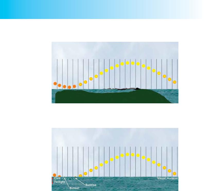
Sunrise and sunset at a particular location on Earth are generally defined as the times when the upper edge of the disc of the Sun is on the unobstructed horizon. Atmospheric conditions are assumed to be average, and the location assumed to be a level region on the Earth’s surface.
As you learnt earlier in the chapter, the tilt of the Earth’s axis relative to its orbital plane about the sun is not only the cause of seasonal change through the course of a year, but also the reason why there is continual change from day to day in the length of the periods of daylight and darkness. In other words, the tilt of the Earth’s axis is the reason why sunrise and sunset occur not only at different times each day for a given location on Earth, but also at different points on the horizon.
The nature and the timing of the variation in sunrise and sunset constitute crucial knowledge for a general aviation pilot, most especially for a pilot who does not possess either an Instrument Rating or a Night Qualification. When planning a flight, a basically qualified general aviation pilot must not, in the United Kingdom, get airborne until half an hour before sunrise, and he must be on the ground by half an hour after sunset.
Figure 2.7 Summer and Winter in the Northern and Southern hemispheres.
The left hand globe in Figure 2.7, above, illustrates that in Summer in the Northern Hemisphere, when the North Pole is tilted towards the Sun, the days are longer in the Northern Hemisphere than in the Southern Hemisphere, which is experiencing Winter, the South Pole being tilted away from the Sun.
In Figure 2.7, the days can be seen to be longer in the Northern Hemisphere during the northern summer by the fact that a smaller area of the Earth, North of the Equator, is in shadow. It should also be clear, that in the northern summer, at the very high latitudes, the Sun is always visible above the horizon, and that there is no night in those latitudes.
CHAPTER 2: TIME
In the United
Kingdom, night is
defined as lasting from half an hour after sunset to half an hour before sunrise.
21
Order: 6026
Customer: Oleg Ostapenko E-mail: ostapenko2002@yahoo.com CHAPTER 2: TIMECustomer: Oleg Ostapenko E-mail: ostapenko2002@yahoo.com
In the northern summer, around 21 June, near the North Pole, the passage of the
Sun across the horizon would appear something like the illustration in Figure 2.8.
Figure 2.8 Mid-summer near the North Pole. The passage of the Sun across the sky in a 24 hour period.
At a slightly lower latitudes than the North Pole, the passage of the Sun across the horizon, at the height of the northern summer, might look like that shown in Figure 2.9, where night lasts for a very short period.
Figure 2.9 Mid-summer at slightly lower latitudes, but still in the far North. Night lasts for only a very short period.
You should note that, exactly at the geographical poles, the Sun sets once a year only.
In the northern summer, it is, of course, winter in the Southern Hemisphere and, as you can see from the left-hand globe in Figure 2.7, the South Pole is experiencing darkness which will last for 6 months.
Six months later, the situation is reversed with the South Pole experiencing a sixmonth long period of daylight, in the southern summer, and the North Pole plunged into a six month night, as depicted in the right hand globe in Figure 2.7.
22

ID: 3658
Customer: Oleg Ostapenko E-mail: ostapenko2002@yahoo.com Customer: Oleg Ostapenko E-mail: ostapenko2002@yahoo.com
How the Time of Sunrise and Sunset Varies.
In contrast to the situation at the geographical poles, daylight and darkness are always of approximately the same duration at the Equator, lasting about 12 hours each. The further one moves from the Equator towards the poles, the greater is the difference between the duration of daylight and darkness. At the poles, as you have already learned, the difference between the length of day and night is the greatest. At the poles, in summer, the Sun does not set, and there is no night, and, in winter, the Sun does not rise, and there is no daylight; daylight and darkness may be said to last 6 months each.
When it is summer in the Northern Hemisphere, then, moving southwards from the North Pole we see that, considering periods of 24 hours, we are passing from 24 hours of continuous daylight, where the Sun does not set, into regions where the Sun rises ever later and sets ever earlier with the period of daylight became shorter and shorter until at the South Pole the Sun does not rise at all and we have 24 hours of continuous darkness. As you have already learnt, this phenomenon of varying lengths of daylight and darkness is explained by the tilt of the Earth’s axis. If the Earth’s axis were perpendicular to its orbital plane about the Sun, the Sun would always rise at 0600 Local Mean Time (LMT) and always set at 1800 LMT.
But because the Earth’s axis is tilted at 66½° to its orbital plane, the length of daylight and darkness varies with latitude. At any given moment, a meridian of longitude has the same local mean time along its whole length, from pole to pole, but, on a given day along that meridian, sunrise and sunset will occur at different times in any given location, depending on the latitude of that location. In other words, local mean time is the same at all locations situated on a given meridian of longitude, but the Sun rises and sets at different local mean times along that meridian depending on the parallel of latitude.
On any specified day of the year, the Sun will, however, rise and set at the same local mean time at all locations of the same elevation on a given parallel of latitude, the duration of daylight being tied to the maximum elevation that the Sun achieves in the sky.
Figure 2.10 On any given date, the relative duration of daylight and darkness depends on the latitude.
Figure 2.10 depicts the Earth in a Northern Hemisphere summer and shows three locations: A, B and C, situated on different parallels of latitude along a given meridian of longitude, about 20° East.
CHAPTER 2: TIME
Local Mean
Time is the same at
all locations situated on a given meridian of longitude, but the Sun rises and sets at different Local Mean Times along that meridian, depending on latitude.
On any given
parallel of latitude, and
on any specified day of the year, the Sun will always rise and set at the same Local Mean Time at locations
of the same elevation.
23

Order: 6026
Customer: Oleg Ostapenko E-mail: ostapenko2002@yahoo.com CHAPTER 2: TIMECustomer: Oleg Ostapenko E-mail: ostapenko2002@yahoo.com
The ICAO definition of
night is: “the period between the end of evening civil twilight and the beginning of morning civil twilight, or such other period between sunset and sunrise as may be described by the appropriate authority. Note that the UK CAA definition of night is different from ICAO’s.
VFR Flight in the United
Kingdom is not permitted at night.
All three locations will have the same local mean time. As Figure 2.10 shows, as the Sun rises at location B, on the Equator, at location A, at approximately 30° North, the Sun has already risen and A has been in daylight for over an hour, while at location C, at about 30° South, the Sun has not yet risen, that location still lying in the darkness of the Earth’s shadow.
On a given day, then, the times of sunrise and sunset at a particular spot on Earth are a function of that location’s latitude.
And, as you have already learnt, at a given latitude, the hours of sunrise and sunset vary with seasonal change. The position of the sunrise and sunset on the horizon will also vary with the seasons. For instance, as the seasons progress, because of the Earth’s axial tilt, sunrise in the Northern Hemisphere occurs in the northeast quadrant from the March (vernal) equinox to the September (autumn) equinox, and in the southeast quadrant from the September equinox to the March equinox. In the southern counties of the United Kingdom, around 52° North, the elevation of the Sun changes by about 50° between midwinter and midsummer.
Twilight.
Before sunrise, there is a short period lasting about half an hour during which it becomes light, and, after sunset, there is a short period of similar duration during which it remains light before darkness sets in. These two periods are called, respectively, morning and evening twilight. Although the Sun is below the horizon, the refraction of the Sun’s rays by the atmosphere gives rise to twilight.
The period of twilight between sunset, and the moment when the centre of the Sun’s disc is 6° below the horizon is called evening civil twilight, and the period, in the morning, from the moment when the centre of the Sun’s disc is 6° below the horizon to sunrise, is called morning civil twilight.
The International Civil Aviation Organisation’s (ICAO) definition of night is the period from the end of evening civil twilight to the beginning of morning civil twilight. During civil twilight, if the sky is not too cloudy and there is no high ground to the East or West, natural illumination is good enough for daylight tasks to be carried out without artificial lighting. For instance, it should be possible to fly a safe visual approach to an unlit runway during civil twilight.
You should note that the actual wording of the ICAO definition of night is: “the period between the end of evening civil twilight and the beginning of morning civil twilight, or such other period between sunset and sunrise as may be described by the appropriate authority”. The United Kingdom has registered a difference with ICAO over the definition of night and, in the United Kingdom, the Air Navigation Order defines night lasting from half an hour after sunset to half an hour before sunrise. VFR flight in the United Kingdom is not permitted during those hours.
When planning a flight, it would be very unwise for a pilot without an Instrument Rating or Night Qualification to plan to land at sunset + 30 minutes, as there would exist absolutely no margin for error in the timing of the flight. And if the sky were overcast, or visibility otherwise poor, darkness may have descended before the onset of “official” night. Planning for this possibility, especially on long navigation flights, is good airmanship.
24

ID: 3658
Customer: Oleg Ostapenko E-mail: ostapenko2002@yahoo.com
Customer: Oleg Ostapenko E-mail: ostapenko2002@yahoo.com
CHAPTER 2: TIME
Standard Time and Daylight Saving Time.
In mid latitudes, or temperate regions, both north and south of the equator, there is great variation in the amount of daylight and darkness as the seasons progress. In order, therefore, that the most effective use can be made of the hours of daylight in summer time, nations in the mid latitudes often adjust the local standard time forwards by one hour during the spring, summer and early autumn months. By doing this, there are fewer hours of darkness in the period when most inhabitants are awake.
The adjustment of the local standard time forwards by one hour is called summer time, or daylight saving time. As we mention above, British Summer Time lasts from March to October. Central European Summer Time is of similar duration.
Natural and Man-made Divisions of Time.
The year, the lunar month, and the day are natural divisions of time, though, as you have learnt, the year does not consist of whole days. Therefore, synchronising the days, and, thus, our calendar, with the seasons, was only really effectively solved by the introduction of the Gregorian Calendar in the 16th Century.
The calendar months, the week, the hour, the minute and the second are artificial man-made divisions of time. A chronometer measuring hours, minutes and seconds is, however, one of the most essential tools of the pilot navigator. So, where do hours, minutes and seconds come from?
The Egyptians are thought to be the first people to have divided the day up into subunits which they marked onto shadow clocks as early as 1300 BC. The day was divided up by the Egyptians into ten divisions of daylight, from sunrise to sunset, two divisions of twilight and twelve divisions of night. This, then, was the origin of the 24hour day. No one knows why this division was based on twelve, but twelve is about the number of cycles of the Moon in a year (a year contains 12.4 lunar months), so twelve may have been a number of special significance to the ancients.
Between about 300 and 100 BC, the Babylonians were carrying out astronomical calculations using the sexagesimal (base-60) system. The sexagesimal system was extremely convenient for simplifying division, because 60 is divisible by 2, 3, 4, 5, 6, and 10.
The first-level sexagesimal division of the hour was what, in English, is now called a minute, and the second-level sexagesimal division was what we now call a second.
25
Order: 6026
Customer: Oleg Ostapenko E-mail: ostapenko2002@yahoo.com CHAPTER 2: TIMECustomer: Oleg Ostapenko E-mail: ostapenko2002@yahoo.com
Time and Dead Reckoning Navigation.
As we defined at the beginning of this book, the pilot-navigator is concerned with finding his way to a destination or turning point by determining the heading to fly in order follow a desired track. The pilot-navigator determines his progress along that track by assessing groundspeed, and, after flying for a given time, using the calculated distance flown to update his position.
In dead reckoning navigation, a pilot determines his present position from an accurately logged history of heading, speed and time. If, after the passage of a given amount of time, at the assumed ground speed, the calculated position is not confirmed by a ground feature, groundspeed, and estimated times
of arrival (ETAs) at future checkpoints and the eventual destination, have to be updated.
Time and timing, therefore, are of crucial importance in navigation. Once a pilot has drawn the desired track on a chart and assessed the probable heading and groundspeed of his aircraft from the wind forecast, he will identify suitable ground features along the track and calculate the time required to reach those features.
Once airborne, by referring to his chart and stop watch, the pilot will either confirm his position along track or update his groundspeed and ETAs.
In light aircraft navigation, the most important of the divisions of time about which you have learned in this chapter is the minute. Confirming the aircraft’s position along track by taking a fix from a planned ground feature is typically made every 5 to 10 minutes, at light aircraft speeds.
In the navigation part of the PPL skills test, a pilot is required to arrive at his destination or declared turning points, within 3 minutes of his ETA. ETAs may, however, be updated along track if an en-route fix (against a planned ground feature) is either early or late.
26