

- •Section 1: System Overview
- •1.1 PFD/MFD Controls
- •1.2 PFD Softkeys
- •1.3 MFD Softkeys
- •1.4 MFD Page Groups
- •1.5 Vertical Navigation
- •1.6 Backlighting
- •1.7 XM Radio - Automatic Muting
- •1.8 Database Updates
- •Jeppesen Aviation Database
- •Garmin Databases
- •Section 2: Flight Instruments
- •2.1 Airspeed Indicator
- •Speed Indication
- •Speed Ranges
- •Airspeed Trend Vector
- •Vspeed References
- •2.2 Attitude Indicator
- •2.3 Altimeter
- •Altitude Reference Bug
- •Altitude Trend Vector
- •Barometric Setting Box
- •Altitude Alerting
- •Metric Display
- •2.5 Marker Beacon Annunciations
- •2.6 Vertical Speed Indicator
- •2.7 Barometric Altitude Minimums
- •2.8 Horizontal Situation Indicator (HSI)
- •Course Pointer
- •Course Deviation Indicator (CDI)
- •Bearing Pointers and Information Windows
- •DME (optional)
- •Navigation Source
- •2.9 Wind Data
- •3.1 Engine Display
- •3.2 Lean Display
- •Normally-aspirated Aircraft
- •Turbocharged Aircraft
- •3.3 System Display
- •4.1 Radio Status Indications
- •4.2 Volume
- •4.3 Automatic Squelch
- •4.4 Quickly Activating 121.500 MHz
- •4.5 Optional NAV Radios
- •DME Radio (optional)
- •ADF Radio (optional)
- •Auto-tuning on the PFD
- •Auto-tuning on the MFD
- •4.7 Transponder
- •Mode Selection
- •Ground Mode (Automatic)
- •Reply Status
- •Code Selection
- •Flight ID Reporting
- •5.1 COM Radio Selection
- •5.2 Marker Beacon Receiver
- •Marker Beacon Signal Sensitivity
- •5.3 Nav Radio Audio Selection
- •5.4 Intercom System (ICS) Isolation
- •5.5 Intercom Squelch Control
- •5.6 Digital Clearance Recorder and Player
- •6.1 AFCS Controls
- •6.2 Flight Director Operation
- •Activating the Flight Director
- •Command Bars
- •AFCS Status Box
- •6.3 Flight Director Modes
- •Pitch Modes
- •Pitch Hold Mode (PIT)
- •Selected Altitude Capture Mode (ALTS)
- •Altitude Hold Mode (ALT)
- •Vertical Speed Mode (VS)
- •Flight Level Change Mode (FLC)
- •Vertical Navigation Modes (VPTH, ALTV)
- •Glidepath Mode (GP)
- •Glideslope Mode (GS)
- •Go Around (GA) Mode
- •Roll Modes
- •Roll Hold Mode (ROL)
- •Heading Select Mode (HDG)
- •Navigation Mode (GPS, VOR, LOC)
- •Approach Mode (GPSa, VAPP, LOC)
- •Backcourse Mode (BC)
- •6.4 Autopilot Operation
- •Flight Control
- •Pitch Axis and Pitch Trim
- •Roll Axis
- •Engaging the Autopilot
- •Control Wheel Steering
- •Disengaging the Autopilot
- •6.5 Example Procedures
- •Departure
- •Intercepting a VOR
- •Flying a Flight Plan/GPS Course
- •Descent
- •Approach
- •Go Around/Missed Approach
- •6.6 AFCS Annunciations and Alerts
- •AFCS Status Alerts
- •Overspeed Protection
- •Section 7: Navigation
- •7.1 Navigation Map Page
- •Select the MAP Page Group
- •Direct-to Navigation from the MFD
- •Enter a Direct-to Destination
- •Select a Direct-to Destination to a Flight Plan Waypoint
- •Select a Direct-to Destination to a Nearest Airport
- •Re-center the CDI to the Destination Waypoint
- •Canceling Direct-to Navigation
- •Direct-to Navigation from the PFD
- •Enter a Direct-to Destination
- •Select a Direct-to Destination to a Flight Plan Waypoint
- •Select a Direct-to Destination to a Nearest Airport
- •Cancelling Direct-to Navigation
- •7.3 Navigating a Flight Plan
- •7.4 Airport Information
- •Select the Airport Information Page
- •Select an Airport from the Database
- •Select an Airport from the Active Flight Plan
- •Select a Nearest Airport
- •Select an Airport by Facility Name or City Location
- •Access Runway Information
- •Access Frequency Information
- •7.5 Intersection Information
- •Select the Intersection Information Page
- •Access Information on an Intersection
- •7.6 NDB Information
- •Select the NDB Information Page
- •7.7 VOR Information
- •Select the VOR Information Page
- •Access Information on a VOR
- •7.8 User Waypoint Information Page
- •7.9 Nearest Airports
- •Nearest Airport Information on the MFD
- •Select the Nearest Airports Page
- •Access Runway Information for the Selected Airport
- •Nearest Airports Information on the PFD
- •7.10 Nearest Intersections
- •Select the Nearest Intersections Page
- •View Information on the Nearest Intersection
- •7.11 Nearest NDB
- •Select the Nearest NDB Page
- •7.12 Nearest VOR
- •Select the Nearest VOR Page
- •View Information on the Nearest VOR
- •Select and Load a VOR Frequency
- •7.13 Nearest User Waypoint
- •Select the Nearest User Waypoint Page
- •Select a Nearest User Waypoint
- •7.14 Nearest Frequencies
- •Select the Nearest Frequencies Page
- •Select and Load the Nearest ARTCC, FSS, or Weather Frequency
- •7.15 Nearest Airspaces
- •Select the Nearest Airspaces Page
- •Airspace Alerts Box
- •View Additional Details for a Listed Airspace
- •View and Quickly Load the Frequency for a Controlling Agency
- •Section 8: Flight Planning
- •8.1 User Defined Waypoints
- •Select the User WPT Information Page
- •Create a New User Waypoint
- •Modify a User Waypoint
- •Delete a User Waypoint
- •Create User Waypoints from the Navigation Map Page
- •8.2 Viewing the Active Flight Plan
- •8.3 Activate a Stored Flight Plan
- •8.4 Activate a Flight Plan Leg
- •8.5 Stop Navigating a Flight Plan
- •8.6 Invert Active Flight Plan
- •8.7 Create a New Flight Plan
- •Create a New Flight Plan Using the MFD
- •Create a New Flight Plan Using the PFD
- •8.8 Load a Departure
- •8.9 Load an Arrival
- •8.10 Load an Approach
- •8.12 Store a Flight Plan
- •8.13 Edit a Stored Flight Plan
- •8.14 Delete a Waypoint from the Flight Plan
- •8.15 Invert and Activate a Stored Flight Plan
- •8.16 Copy a Flight Plan
- •8.17 Delete a Flight Plan
- •8.18 Graphical Flight Plan Creation
- •8.19 Trip Planning
- •Section 9: Procedures
- •9.1 Arrivals and Departures
- •Load and Activate a Departure Procedure
- •Load and Activate An Arrival Procedure
- •9.2 Approaches
- •Load and/or Activate an Approach Procedure
- •Activate An Approach in the Active Flight Plan
- •Section 10: Hazard Avoidance
- •10.1 Customizing the Hazard Displays on the Navigation Map
- •10.2 STORMSCOPE® (Optional)
- •Displaying Stormscope Lightning Data on the Navigation Map Page
- •Stormscope Page
- •10.3 XM Weather (Service Optional)
- •Displaying METAR and TAF information on the Airport Information Page
- •Displaying Weather on the Weather Data Link Page
- •NEXRAD Limitations
- •Weather Products & Symbols
- •Weather Product Age
- •10.4 Traffic Information Service (TIS)
- •TIS Voice Alert
- •10.5 Traffic Advisory System (TAS) (Optional)
- •System Self Test
- •10.6 Terrain and Obstacle Proximity
- •Displaying Terrain and Obstacles on the Terrain Proximity Page
- •Displaying Terrain and Obstacles on the Navigation Map
- •10.7 Terrain Awareness & Warning System (TAWs) Display (Optional)
- •Displaying Terrain on the TAWS Page
- •Enable/Disable Aviation Data
- •TAWS Inhibit
- •Manual System Test
- •Forward Looking Terrain Avoidance (FLTA)
- •Reduced Required Terrain Clearance (RTC) and Reduced Required Obstacle Clearance (ROC)
- •Imminent Terrain Impact (ITI) and Imminent Obstacle Impact (IOI)
- •Premature Descent Alert (PDA)
- •Excessive Descent Rate Alert (EDR)
- •Displaying Terrain and Obstacles on the Navigation Map
- •Pop-up Alerts
- •TAWS Alerts Summary
- •Alert Annunciations
- •11.1 Reversionary Mode
- •11.2 Abnormal COM Operation
- •11.3 Unusual Attitudes
- •11.4 Stormscope operation with loss of Heading Input
- •11.5 Hazard Displays with Loss of GPS Position
- •11.6 Dead Reckoning
- •12.1 Alert Level Definitions
- •12.2 NAV III Aircraft Alerts
- •WARNING Alerts
- •CAUTION Alerts
- •12.3 CO Guardian Messages
- •12.4 AFCS Alerts (182 & 206 Only)
- •System Status Annunciation
- •12.5 TAWS Alerts
- •12.6 G1000 System Annunciations
- •12.7 G1000 System Message Advisories
- •MFD & PFD Message Advisories
- •Database Message Advisories
- •GMA 1347 Message Advisories
- •GIA 63 Message Advisories
- •GIA 63W Message Advisories
- •GEA 71 Message Advisories
- •GTX 33 Message Advisories
- •GRS 77 Message Advisories
- •GMU 44 Message Advisories
- •GDL 69A Message Advisories
- •GDC 74A Message Advisories
- •Miscellaneous Message Advisories
- •Index
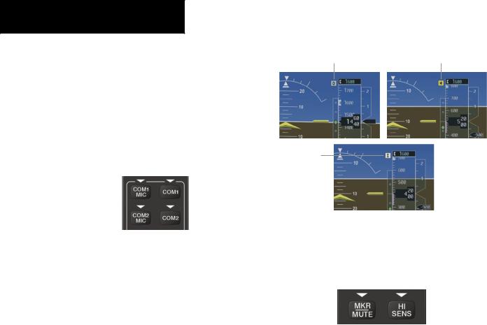
SECTION 5 – AUDIO PANEL
5.1COM RADIO SELECTION
Pressing the COM1 MIC or COM2 MIC Key selects the active transmitter (i.e., microphone). The associated receiver audio (COM1 or COM2) also becomes selected when the COM MIC Key is pressed.
To prevent deselecting the desired received audio when pressing another COM MIC Key, press the already selected COM1 or COM2 Key before pressing the other COM MIC Key.
Figure 5-2 Transceivers
5.2MARKER BEACON RECEIVER
The marker beacon receiver is always on. Only the marker beacon audio can be turned off. Figure 5-3 shows the marker beacon annunciators on the PFD.
When the MKR/MUTE Key is pressed, the key annunciator is lit and the audio tone can be heard over the speaker or headsets during marker beacon reception.
When the tone is active, pressing the MKR/MUTE Key once mutes the audio but does not affect the marker annunciator. The audio returns when the next marker signal is received.
To turn off the marker beacon audio, press the MKR/ MUTE Key once when there is no marker indication present, or press twice when an indication is present. The key annunciator will be extinguished when the marker beacon audio is turned off.
Outer Marker |
Middle Marker |
Annunciator |
Annunciator |
Inner Marker
Annunciator
Figure 5-3 Marker Beacon Annunciators on the PFD
Marker Beacon Signal Sensitivity
The HI SENSKey can be pressed for increased marker beacon signal sensitivity.
Figure 5-4 Marker Beacon
5-2 |
Garmin G1000 Cockpit Reference Guide for the Cessna Nav III |