![](/user_photo/2706_HbeT2.jpg)
- •Contents at a Glance
- •Contents
- •Hardware Hacks
- •GPS Secrets
- •Hidden Secrets
- •Garmin Secret Screens
- •Hard Resets
- •Soft Resets
- •Warm Resets
- •Full GPS Resets
- •Diagnostic Screens
- •Autolocating
- •Magellan Secret Screens
- •Magellan Meridian Series
- •After a Hard or Soft Reset
- •Summary
- •Cables Demystified
- •The Data Cable
- •Power Cords
- •Combo Cables
- •Combining Cable Types
- •Multi-GPS Cables
- •Multi-Data Cables
- •Multi-Data/Power Cables
- •Multi-Data/Power/GPS Cables
- •Making Your Own Data Cables
- •Materials You Will Need
- •Don’t Want to Buy a Connector?
- •Making Power Cords
- •Power Cord Assembly
- •Testing
- •Precautions
- •GPS/iPAQ Connections
- •Cradle Modification
- •Testing the Connection
- •Making Combo Cables
- •Making Multi Cables
- •Summary
- •Power Hacks
- •GPS Power Needs
- •Alkaline Batteries
- •Lithium Batteries
- •Rechargeable (NiMH) Batteries
- •Battery Do’s and Don’ts
- •Power Hacks
- •Carrying Your Own 12-Volt Power Supply
- •Battery Packs
- •A Different Kind of Battery Pack
- •Alternative Power Supplies
- •Summary
- •Antenna Hacks
- •The GPS Antenna
- •Quad-Helix Orientation
- •Patch Antenna Orientation
- •Best Performance Summary
- •External Antennas
- •Antenna Placement
- •Other Things to Avoid
- •Reradiating Antennas
- •Personal Reradiating Antenna
- •Communal Reradiating Antenna
- •Reradiating Antenna Considerations
- •Setting Up a Reradiating Antenna in a Car
- •Testing the System
- •Making the System Permanent
- •Carrying a GPS Signal via Cable
- •How Much Signal Do You Need?
- •Cable Losses
- •Connector Losses
- •Using a Signal Repeater
- •Building Your Own Mega GPS Antenna
- •Materials
- •Building the Antenna
- •Summary
- •Screen Damage
- •Screen Protectors
- •More Screen Armoring
- •Commercial Protection for GPS and PDAs
- •Mounting GPS
- •Car Mounting
- •Mounting a GPS for Biking, Hiking, and Skiing
- •Making a Personalized Case
- •Summary
- •Software Hacks
- •Hacking the Firmware
- •Firmware
- •Updating Warnings
- •Updating the Firmware
- •Hacking GPS Firmware
- •Bypassing the Garmin eTrex Vista Startup Screen
- •Bypassing the Garmin eTrex Legend Startup Screen
- •Bypassing the Garmin eTrex Venture Startup Screen
- •MeMap Personalization
- •Manual Firmware Editing
- •Magellan GPS Firmware Modifications
- •Recovering from a Failed Firmware Load
- •Garmin
- •Magellan
- •Summary
- •Connection Types
- •Which Connection Is Best?
- •Troubleshooting Problems
- •PC Connection Trouble
- •General PDA Connection Trouble
- •General Bluetooth Connection Trouble
- •Software-Specific Issues
- •Erratic Mouse Pointer after Connecting a GPS
- •Windows XP Problem: Microsoft Ball Point
- •Microsoft MapPoint Troubleshooting
- •USB-to-Serial Converters
- •Summary
- •GPS Data Collection
- •Position, Velocity, Time
- •Waypoints
- •Working with the Data
- •EasyGPS
- •G7toWin
- •Creative Uses of GPS Data
- •Sharing Waypoints
- •Adding GPS Information to Digital Photos
- •Lightning Detector and Plotter
- •Wardriving
- •GPS in Programming
- •Summary
- •Examining the Data
- •NMEA
- •NMEA Sentences
- •NMEA Sentence Structure
- •A Closer Look at NMEA Sentences
- •Examining NMEA Sentences
- •NMEA Checksum
- •SiRF
- •Using NMEA Sentences
- •GPS NMEA LOG
- •GPS Diagnostic
- •RECSIM III
- •Using NMEA
- •GpsGate
- •Recording Actual NMEA Sentences with GpsGate
- •Recording Simulated NMEA Using GpsGate
- •Data Playback
- •Why Bother with NMEA?
- •Ensuring That Your GPS Works
- •Avoiding Data Corruption
- •Summary
- •More Data Tricks
- •Screenshots
- •G7toWin
- •G7toCE
- •Turning Your PC into a High-Precision Atomic Clock
- •Setting Up the Software
- •Setting Up the Hardware
- •Hooking Up Hardware to Software
- •Bringing a GPS Signal Indoors
- •Other Uses for GPS Data
- •Azimuth and Elevation Graphs
- •Surveying
- •Navigation
- •Signal Quality/SNR Window
- •NMEA Command Monitor
- •Experiment for Yourself
- •Summary
- •Playtime
- •Hacking Geocaching
- •GPS Accuracy
- •The Birth of Geocaching
- •Geocaching Made Simple
- •What Is Geocaching?
- •Geocaching from Beginning to End
- •The Final 20 Yards
- •Geocaching Hacks
- •Go Paper-free
- •Plan Before You Leave
- •Sort Out Cabling
- •Power for the Trip
- •Better Antennas
- •Protecting the GPS
- •Summary
- •GPS Games
- •The Dawn of GPS Games
- •Points of Confluence
- •Benchmarking/Trigpointing
- •GPS Drawing
- •Hide-and-Seek
- •Foxhunt
- •Other Games
- •Summary
- •GPS Primer
- •The GPS Network
- •How GPS Works
- •GPS Signal Errors
- •Summary
- •Glossary
- •Index
![](/html/2706/250/html_1VIl6o50AN.c8Rr/htmlconvd-XwbVzv188x1.jpg)
Chapter 8 — GPS Data 171
FIGURE 8-8: Time zone information
FIGURE 8-9: Daylight saving information
Some GPS receivers, either when you buy them or when they have had exhausted batteries in them for some period of time, will ask you to input the time and date manually — this helps the receiver get a lock on the satellites, and the time will be corrected when the almanac has been downloaded.
Waypoints
A waypoint is a spot on the surface of the Earth as defined by coordinates that are inputted into the GPS and stored, usually along with an icon, a descriptive name, and some text.
There are two types of waypoint:
Manual waypoints
On-the-spot waypoints
![](/html/2706/250/html_1VIl6o50AN.c8Rr/htmlconvd-XwbVzv189x1.jpg)
172 Part III — Data Hacking
Manual Waypointing
A manual waypoint is one that you enter into the GPS for a location that you are not currently at. For example, before you leave home, you might enter the waypoint of the parking lot at your destination or perhaps the geocache that you are looking for (see Figure 8-10).
FIGURE 8-10: Manual waypointing
To enter a manual waypoint, you need to know the coordinates of the location to which you are heading. For this you need a map of some kind or some other repository of coordinates (a map, geocache listing, points of interest, etc.).
Be very careful when manually entering waypoint information into your GPS because a small numerical error can translate into a massive error on the ground! In addition, make sure that you’re using the appropriate datum for the coordinate system being used (for degrees/minutes/ seconds, degrees/minutes, and decimal degrees, use WGS84). Using the incorrect datum can cause inaccuracies of several hundred meters.
Coordinates form the fundamental aspect of navigating with a GPS other than using dead reckoning (where you follow a path and a bearing for a certain distance over a certain amount of time), and getting comfortable with using them is the first step to really using GPS properly.
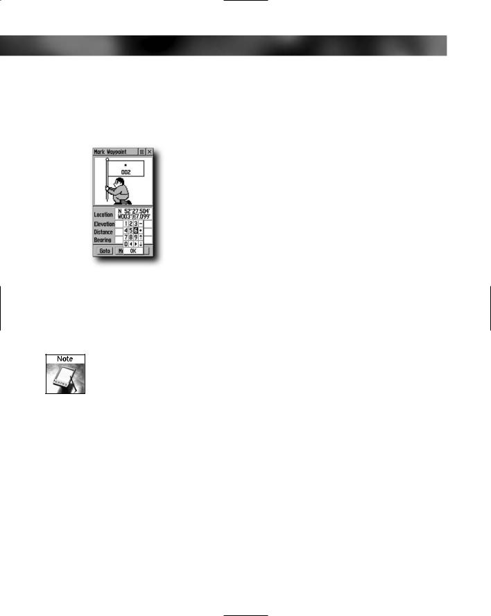
On-the-Spot Waypointing
With on-the-spot waypointing, you travel to a place and waypoint that particular location, storing the waypoint in your GPS. This stores the location that is displayed by the GPS into the memory of the device. You can then navigate back to this spot later. For example, you could waypoint the location of your car before going off in search of a geocache so that you are sure to find it on the way back).
Routes
Routes are path data that is stored in the GPS. A route is a series of waypoints contained in the GPS that form a path of travel, similar to the connect-the-dots activity found in children’s activity and puzzle books.