

NP 286(1) United Kingdom and Europe
.pdfContents Index
UNITED KINGDOM
Reporting Point
Solent East Approach
On an arc IOn miles from the Nab Tower Lt
(50 0 40'·OSNOO57'·15W)
500 36'·40NO·5S'·IOW (Vessels constrained by draught)
50°3S'·09N0°57'-29W (Vessels constrained by draught)
Nab Tower (or when Pilot boarded) specify distance Eor Wof tower
Nab Tower (or when Pitot boarded, and include ETA Outer Spit Lt buoy)
Warner Lt buoy
Gas tankers; before navigating between Warner and NSturbridge Lt buoys
Approaching No Man's
Land Fort
Saddle Lt buoy
Before entering the Swashway Channels
Southampton VTS (VHF
Ch 12)
"
"
..J
"
..J
..J
S. Ryde Middle Lt buoy |
|
|
Solent West Approach |
|
|
Needles Channel |
..J |
|
Fairway Lt buoy |
||
|
||
Yarmouth, Isle of Wight |
..J |
|
Between West and East |
" |
|
Lepe Lt Buoys |
||
|
||
Prince Consort Lt buoy, |
|
|
Cowes Roads (include |
|
|
ETA Outer Spit Lt buoy) |
|
OHM Portsmouth (VHF I Ch 11 or 13)
i
..J
..J
..J
"
"
..;
NSturbridge Lt buoy |
|
|
Before entering the |
|
|
Swashway Channels |
|
|
Saddle Lt buoy |
|
|
Southampton Water |
|
|
Calshot Castle/Hoo" |
" |
|
Lt buoy |
||
|
(5) Outward-bound vessels:
I"
"
..J
Reporting Point |
Southampton VTS on |
OHM Portsmouth on |
|
VHFCh 12 |
VHF Ch 11 or 13 |
|
|
|
|
||
Southampton Water |
|
|
|
Pier Head, Southampton |
" |
|
|
Crosshouse Bn, R. lichen |
|
|
|
Hythe Pier |
·v" |
|
|
Calshot Castle/Hook Lt |
" |
|
|
buoy |
|
|
|
Gas tankers: before |
|
I |
|
navigating between |
|
-J |
|
Warner and NSturbridge |
|
|
I |
Lt buoys |
|
|
i |
|
|
|
401

Contents |
Index |
|
|
UNITED KINGDOM |
|
||
Reporting Point |
|
Southampton VTS on |
OHM Portsmouth on |
|
VHFCh 12 |
VHFCh 11 or 13 |
|
|
|
||
Portsmouth |
|
|
|
Southsea War Memorial |
..J |
|
|
SadcIe Lt buoy |
|
" |
|
Solen! (Eastward) |
|
- |
|
No Man'Sland Fori |
|
..J |
|
|
|
||
5Oo42'·73N OOSS'·74W |
|
|
|
(Vessels constrained by |
" |
|
|
draught) |
|
|
|
Nab Tower. specily |
|
|
|
cistance Eor W01 tower |
" |
|
|
The Solen! (Westward) |
|
||
Yarmouth. Isle of Wight |
" |
|
|
RADAR SERVICE AREA:
Radar coverage is available throughout the area monitored by Southampton VTS (see diagram THE SOlENT. SOUTHAMPTON AND PORTSMOUTH VESSEL TRAFFIC SERVICES).
RADAR ASSISTANCE:
Available on request to Southampton Vessel Traffic Service (VTS). Vessels can be supplied with continuous inlormation abOut their progress relative to navigational marks. other vessels. channel margins and West Bramble and CalshOlturns.
INCIDENT REPORTS:
(1) Any incident that reflects on sale port operation is to be reported immediately to the Southampton Hr Mr on VHF Ch 12 or 14. or by telephone to Southampton VTS ~ within the limits 01 the PorI 01 Southampton. or to the Queen's Harbour Master (OHM) Portsmouth on VHF Ch 11 or 13 when within the limits 01 the Dockyard Port 01 Portsmouth. Alternatively. contact can be made by telephone and lollowed by awritten report il requested. Apro lorma lor the 'PilotageIncident Report (PIR1), is ava~able to download from the port webSite (www.southamptonvts.co.uk). or it may be completed and lorwarded electronically.
(2)Such incidents are considered to be those that involve:
(a)Damage to vessels
(b)Movement 01 or damage to navigational marks
(e) Damage to shore facilities whether or not affecting the use of such facilities
(d)Close quarters situations between two or more vessels. which resuH in emergency action on the part 01 the vessels involved
(e)Other 'near miss'incidents with the potentia/to have caused injury or damage
(3)Vessels are additionally requested to report any potential risks encountered in harbour or pilotage waters by use 01 \he 'PotentialRisk Report'pro lorma available on the port website.
(4)In cases when damage is caused to commercial installations the Hr Mr. Southampton or Port Manager. Portsmouth is also to be informed.
(5)Vessels which have sustained damage outside the limits of the Pori of
Southampton or the Dockyard Port 01 Portsmouth which allects. or is likely to allect. the seaworthiness of Ihe vessel, or noil or dangerous or inllammable substances are escaping or are likely to escape from the vessel. must inlorm the Hr Mr belore entering
the Pori 01 Southampton or the OHM Portsmouth belore entering the Dockyard Pori 01 Portsmouth. Such vessels are to wait outside the port limits until permission to enter is given by the Hr Mr or OHM as releVant.
(6)Advice to the Hr Mr may be sent to Southampton VTS on VHF Ch 12 or by lax. Advice to the OHM may be sent on VHF Ch 11.
(7)In order thai oil poUUlion may be effectively deall with. vessels and recreatiOnal cralt sighting signifICant patches 01 oil in the sea in the Pori of Southampton, Southampton Water, The Solent and Portsmouth Harbour are inv~ed to report the sighting stating:
(a)Position
(b)Extent
(c)Description (e.g. lightlilm, slick, heavy black. crude etc.)
(d)Direction 01 movement npossible
(8)Reporis should be made by VHF or telephone to the following:
(a)Hr Mr Southampton
(b)OHM Portsmouth
(c)In the case of recreational craft: HM Solent Coastguard
(9)These reports will be forwarded to the appropriate authorities who will then put into operation all the necessary action to deal with the pollution.
402


Contents Index
UNITED KINGDOM
SERVICE:
This is a UK designated port VTS and provides the following types of service:
(1) Information Service
(2) Traffic Organisation Service
CONTACT DETAILS:
Call: Sullom Voe VTS
VHF Frequency: Ch 16; 0910 (Emergency, lire or oil pollution) 121420
Telephone: +44(0)1806242344 (H24)
Fax: +44(0)1806 242118
E-mail: sullomvoevtS@sheliand.gov.uk
HOURS:H24
PROCEDURE:
(1) Notice of ETA: Vessels bound for Sullom Voe are required to provide the Harbour Authority with an ETA 24h before arrival, or on leaving the last port (whichever is later), Vessels should contact Sullom Voe VTS bye-mail, fax or telex, stating the following information:
(a) All vessels:
(i) |
Vessel'sname, call sign and MMSI |
(ii) |
Port of registry |
(iii) |
Name of Master |
(iv) |
GT |
(v) |
Summer deadweight (MT) |
(vi) |
LOA and moulded depth (in metres) |
(vii) |
Draught (fore and aft) |
(viii) |
Maximum departure draught |
(ix) |
Bunl\erslfresh water/stores quantity |
(x) |
Whether loaded or in ballast. If loaded, nature and quantity of cargo |
(xi) |
Whether vessel is carrying segregated ballast |
(xii) |
If so, quantity and at which port it was taken on board |
(xiii) |
Dirty ballast quantity |
(xiv) |
Berthing deadweight as a percentage of the summer DWT (minimum |
|
acceptable 35%) |
(xv) |
The Pilot Station identified for arrival |
(xvi) |
Pilot boarding arrangements |
(xvii) |
Vessels with freeboard in excess of 18m are instructed to confirm |
|
whether the accommodation ladder can be secured to the vessel's |
|
side by means of acleal or sucker pad to prevent excessive movement |
|
of the lower end of the accommodation ladder In adverse swell |
|
conditions |
(xviii) |
Number of crew |
(xix) |
Last port of call |
(xx) |
Berthing displacement (lonnes) |
(xxi) |
Pand f Club name |
(xxii) |
Previous cargo type |
(xxiii) |
Is all navigation, safety, anchoring and mooring equipment fully |
operational and ready for use? If not, specify. All anchors to be cleared away on arrival at the Pilot station
(xxiv) SWL of after towing billS and fairlead (for connecting escort tug) (XXV) Whether the vessel complies with the Merchant Shipping (Vessel
Traffic Monitoring and Reporting Requirements) Regulations 2004 (EG Directive 2002l59/EEC)
(xxvi) Confirm the engines will be tested to come astern before the Pilot comes on board
(xxvii) Vessel'sInmarsat number and telex number
(xxviii) Confirm whether vessel arriving from Eor Wof Shetland
(xxix) Confirm that all segregated ballast tanks will be accessible for sampling by terminal'sstaff on arrival
(xxx) Confirm that there is a valid Safety Management Certificate onboard (xxxi) Confirm that there is a copy of a valid Document of Compliance
onboard
(xxxii) Confirm that there is a valid International Ship Security Certificate (ISSC) onboard
(xxxiii) Confirm vessel'ssecurity level ib) Crude Oil Tankers:
(xxxiv) Confirm whether vessel has a fully operational inert gas system and whether all cargo/dirty ballasttan~s are under positive pressure and inerted to a maximum of 8% oxygen content
(xxxv) Confirm that tanks to be vented to atmosphere have gases less than 5ppm hydrogen sulphide
(xxxvi) Confirm vessel has afully operational closed loading and tank gauging
system
(xxxvii) Confirm vessel'slast two cargoes prior 10 arrival at Sullor;" Voe h3\'o? been wet cargoes (OBOs only;
409

Contents Index
UNITED KINGDOM
(c)Gas Tankers:
(xxxviii)Conlirm vesset has a valid IMO Certificate lor cargo equipment
(xxxix)Confirm the inert gas plant is fully operational
(xl) |
Confirm compressors and reliquification plant are fully operational |
|
(Note: a vapour return line is filled for emergency use only. The |
|
terminal does not receive vapours back to shore) |
(xti) |
Conlirm cargo alarm system is lully operational |
(xlii) |
The valve closing line lor emergency shut down should not exceed 30 |
|
seconds. Conlirm valve closing time |
(xliii) |
Conlirm the vessel can present suitable 1501300 ASA manilold |
|
presentation llanges (terminal has two 12 inch and one 8 inch |
|
connection lor liquid or vapour service). Reducers are not supplied. |
(xliv) |
Advise manilold conliguration Irom lorward (e.g. L-V-V-L) |
(2)Vessels should confinn ETA 6h in advance and subseQuently report any amendments to ETA 01 more than 1h.
(3)Vessels should send ETA when within VHF range on VHF Ch 14.
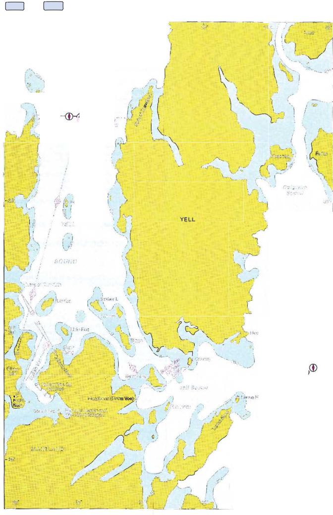
(4)Vessels entering or teaving the Sullom Vee harbour area or transiting Yeti Sound are requested to contact Sullom Vee VTS on VHF Ch 14.
(5)listening watch: Vessels in Shetland waters should keep watch on VHF Chs 14 and 16.
(6)Fishing vessels should report their intentions to SulJom Vee VTS and update every 2h when operating in the deep water channel marked by:
(a)The GIuss Isle Ldg Lts
(b)The while sector 01 OueyIirth Lt (600 31'·50N 1°19'·50W)
(c)The white sector 01 Skaw Taing Lt (60°29'·10N°16'·70W)
(d)Fugla Ness or Sella Ness Ldg Lts
(7)"Areas to be Avoided" and ·PrecautionaryAreas·have been established around the Shetland Istands. Vessels should comply with all regulations relevant to traffic movements. both within and outside these areas. If unable because 01 emergency to comply. or if a breakdown and drifting occurs within 20 n miles 01 the coastline. Sullom Vee VTS should be contacted on VHF Ch 14 or by lax. telex or e-mail.
(8)Prior to sailing Irom Sullorn Vee. all vessels are requested by the Harbour Authority to indicate whether eastbound or westbound from Pilot Station.
(9)During transits 01 Yell Sound and approaches to Sullom Voe. all vessels should report to VTS when passing the REPORTING POINTS.
REPORTING POINTS:
(1) Vessels using N entrance:
Name
A
B
C
D
...IUG. |
~ |
600 38'·19N1°14'·95W(1 ·8n miles E01 Point 01 Fethaland ~_I)_
60·3S'·03N1°16'-62W(0·35 n miles Wol Muckle Holm Lt)
600 31''30N°18'·60W(0·5n miles Eof Queyfirth Lt)
--
60°29'·47N1°17'77W. (0·4n miles WNW 01 S~aw Taing Lt)
(2) Vessels using SE entrance:
Name |
Position |
X |
600 28'·4SN1°10'·9SW(1·25n miles N01 Mossbank Lt) |
_ . |
600 29'·47N1°17'·77W(0·4 n miles WNW 01 Skaw Taing Ltl |
D |
COLGRAVE SOUND ANCHORAGE:
(1)Belore using this anchorage vessels should ask VTS which designated anchorages are unoccupied.
(2)They should subsequently repor1their actual anchored position.
(3)This anchorage is only suitable during the summer months.
INFORMATION BROADCASTS:
(1)Trafiie information is available on request by contacting Sullom Vee VTS on VHF Ch 14.
(2)Local weather forecasts will be broadcast on request. Call Sullom Vee VTS on VHF
Ch 14.
(3) Details of conditions prevailing in the harbour are available on request.
RADAR SURVEILLANCE:
Maintained in Yell Sound and Sullom Vee.
RADAR ASSISTANCE:
Available on request.
410